
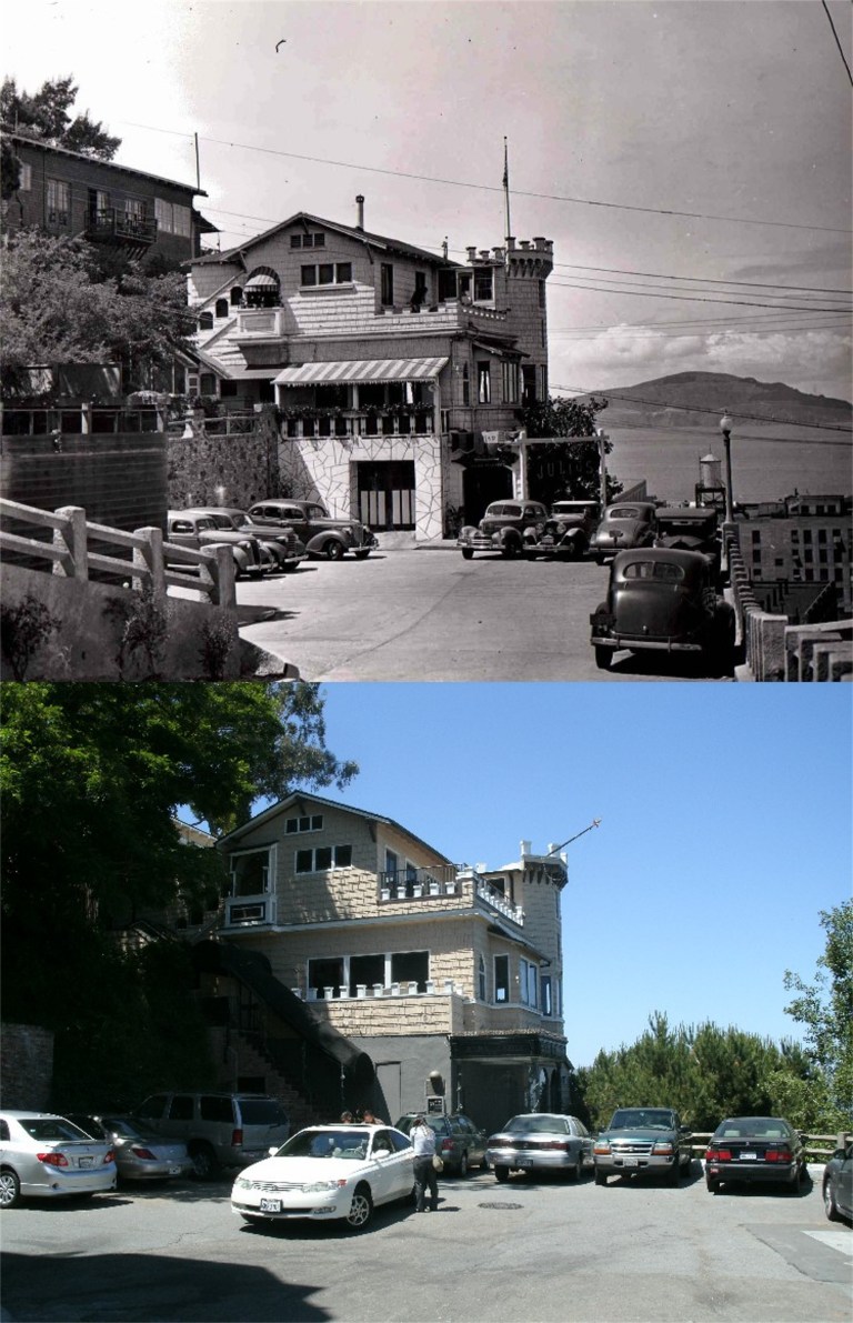
 Julius Castle on Telegraph Hill in the 1940’s: A favorite hangout Dashiell Hammett’s private detective Sam Spade, this building was also the setting for the 1951 film ‘The House on Telegraph Hill’. The restaurant closed in 2007.
 The Trans Bay Terminal Building on Mission Street in the 1940’s: It was because of bus trips from the East Bay as a teenager to this building that I first discovered the world of San Francisco. The bottom picture was taken in August of 2010 on the day the Trans Bay Terminal Building closed forever.
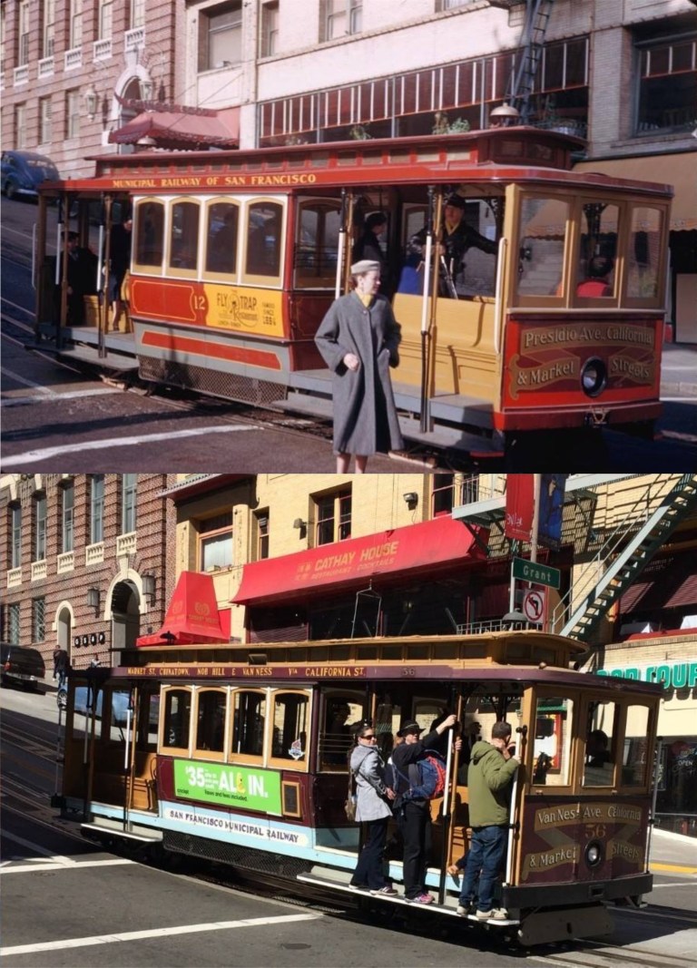
 Yes, I’m very proud of myself with this one. By a careful study of Google Maps, countless trips to Chinatown, and a reliance on my own knowledge of San Francisco, I was able to determine that the vintage photo here was taken at Clay Street and Grant Avenue!
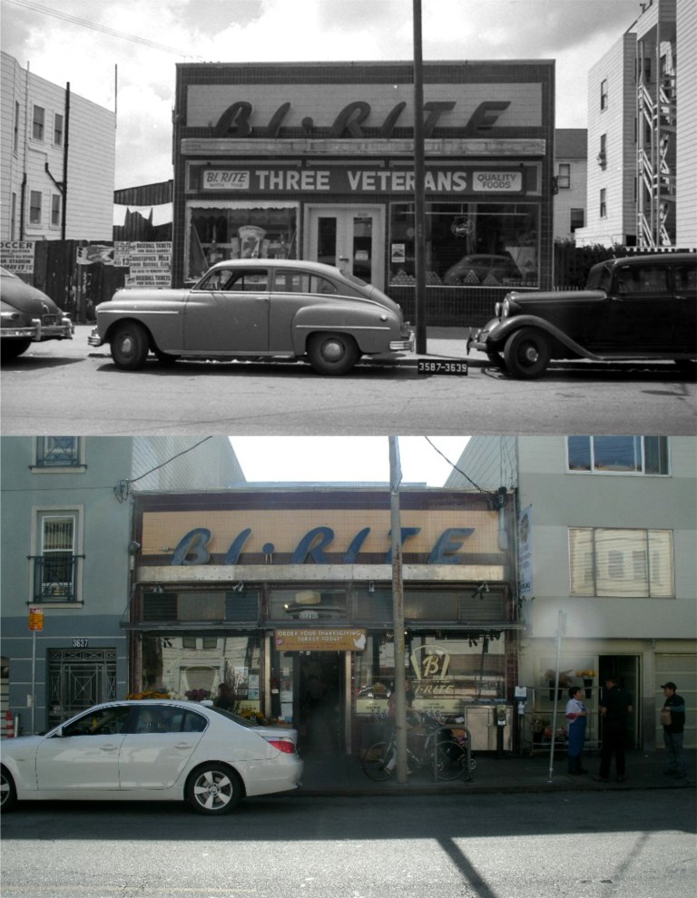 The Bi-Rite Grocery Store on 18th Street in the Mission District has been around since, at least, World War Two, and was still in business as of last Thanksgiving
 The Vaillancourt Fountain is, easily, the most controversial fountain in San Francisco. It looks like the entrails of a giant robot! Here Poppa Cop and Buddy Boy pass by the fountain in a 1972 episode of ‘The Streets of San Francisco’. Notice the Embarcadero Freeway in the background.
 Justin Herman Plaza from the Vaillancourt Fountain in the same episode of the ‘Streets of San Francisco’ and today: This was ground central for the 2016 Super Bowl City.
 “Mommie Dearest” on Russian Hill: Joan Crawford attempts to sneak into the Tamalpais Apartment Building at Greenwich and Hyde where Jack Palance lives to try to find out why he’s trying to kill her in the 1952 film noir movie ‘Sudden Fear’. Joan, what difference does it make why he’s trying to kill you? He’s trying to kill you! Do you really want to go in there?
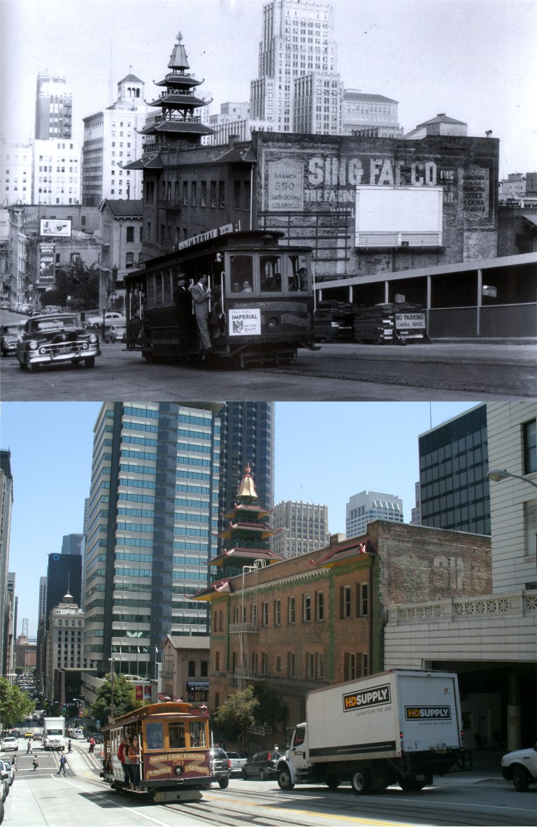 A cable car runs up California Street past the Sing Fat Building on the corner of Grant Avenue in the 1950’s: The open area on the right was where the Trafalgar Building, apparently just recently demolished, stood. That building was the location of Bob Hope and Allan Ladd’s offices in the 1947 comedy ‘My Favorite Brunette’ and was where the parking garage behind the HD Supply truck is today
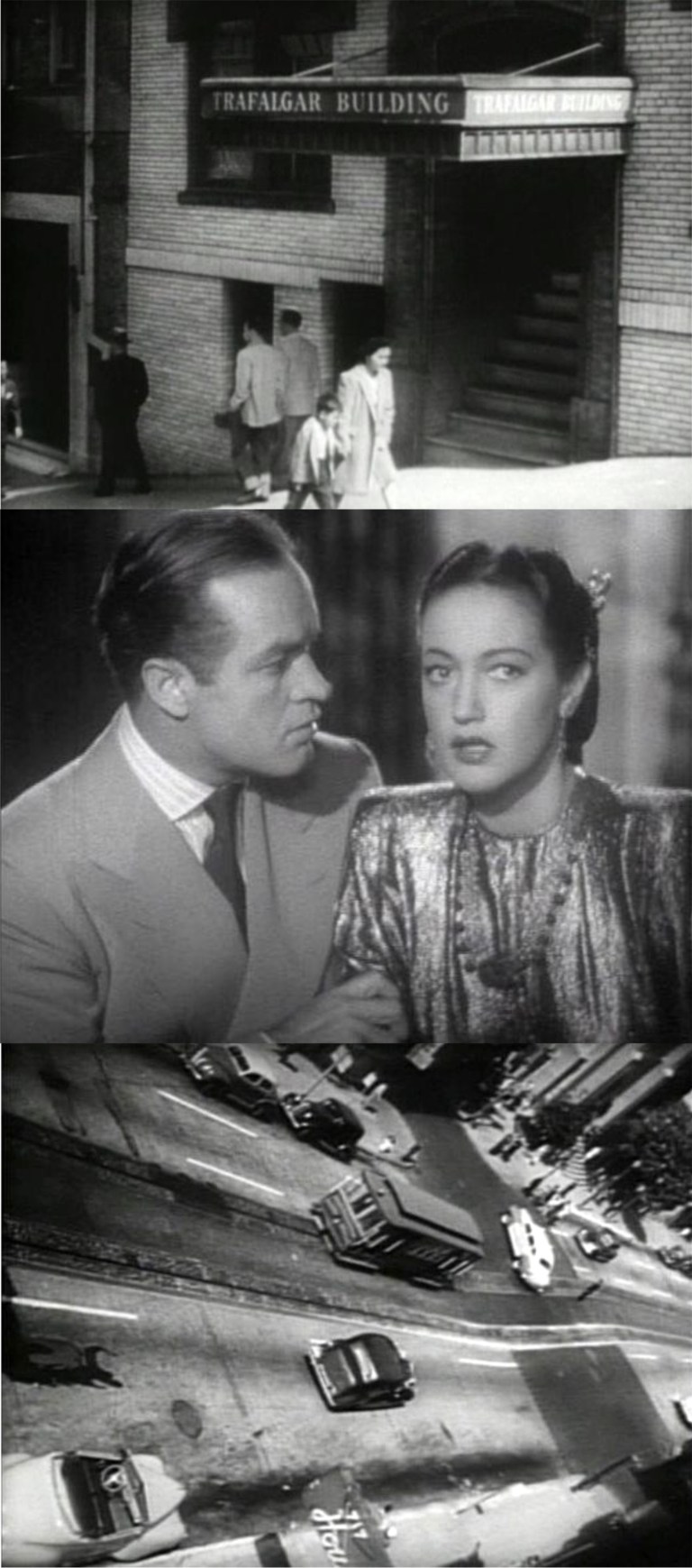 In scenes of the Trafalgar Building from ‘My Favorite Brunette’, one shot has Bob Hope looking down to California Street from an office window as Peter Lorre, the dark car, follows Dorothy Lamour in a taxi cab as she turns left onto Grant Avenue. Bob Hope’s car is the white convertible at the lower left.
 Bob Hope’s view from the Trafalgar Building down to the California Street sidewalk as Dorothy Lamour enters the taxi cab:
 An old postcard of this location shows the Trafalgar Building with the faded advertisement that looks like some type of champagne bottle just to the right of the cable car climbing California Street.
 Cushman and the brakeman: A Cushman Collection photo from the early 1950’s at California Street and Grant Avenue.
 This is a very interesting postcard sent after the 1906 Earthquake and Fire. It reads, “Dear Hilla (or Lilla): This was but a small portion of SF and was, of course, entirely destroyed. The reports of (something) have not been exaggerated. Frisco is badly crippled. Clara”. The remodeled Call Tower, the tallest building in the old photo, is the brown and white striped building in about the same area of the frame in the modern picture.
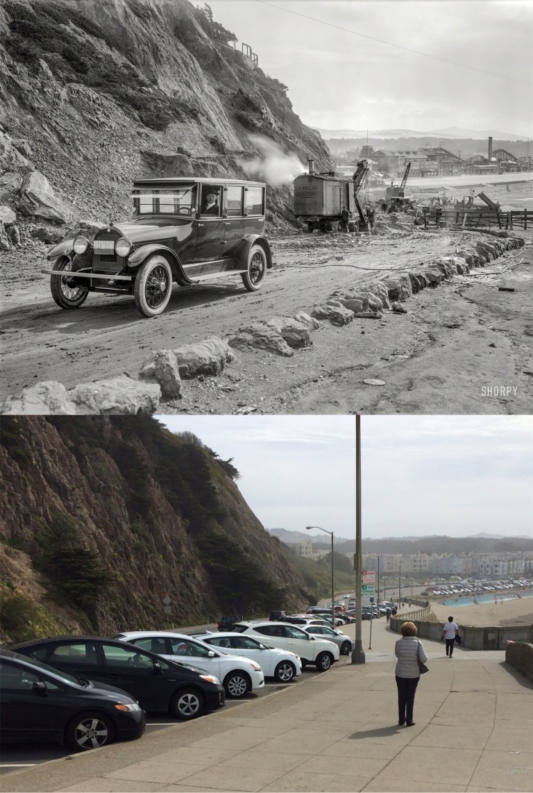
 The Cliff House, looking from the north and south from the terrific Shorpy Picture Archive: They have some of the best vintage pictures I’ve ever seen. Below, is the link to their site. The top photo is looking south toward the Great Highway and Playland-at-the-Beach, (then known as Chutes at the Beach) in 1922 as the road to the Cliff House was being constructed: That thug in the car in the vintage picture looks like a hit man! The second picture is looking north toward the Cliff House in 1934 from the Great Highway: The family in the center car looks happy; I guess they were going to stop at Playland.
  The billboard in the previous picture is an advertisement for Topsy’s Roost with their 50 cent chicken dinners. Topsy’s Roost, seen here in photos from the Marilyn Blaisdell Collection, also had a dance floor in the basement that guests reached by sliding down large slides. Topsy’s was just a short way down from the corner of Balboa Street and the Great Highway, and would later house a slot car race track, and the Family Dog rock and roll concert hall. The building was demolished in the 1970’s and an empty lot occupies the spot today.
 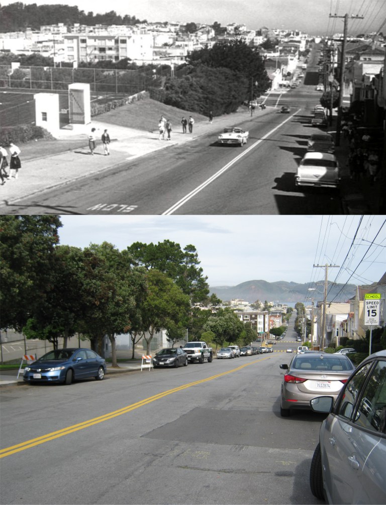 Looking down 30th Avenue toward Geary from Anza St in the Richmond District as Lee Remick drives Stefanie Powers to George Washington High School, on the left, in the 1962 thriller ‘Experiment in Terror’:
 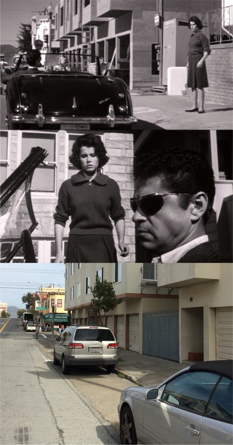 At 25th and Clement, six blocks away from George Washington High School, Ross Martin kidnaps Stefanie at this corner in ‘Experiment in Terror’ The apartment building on the corner was still being built when the scene was filmed.
  Two great pictures from the Shorpy’s Collection at the southeast corner of Arguello and Geary in 1927: Although, the picture of the cop scolding the lady jaywalker was, obviously, posed, I still like it. The Golden Bear Furniture building was where the red building with the circle windows is today. They still have a street signal and fire hydrant here, but the old hydrant was replaced by another old hydrant.
 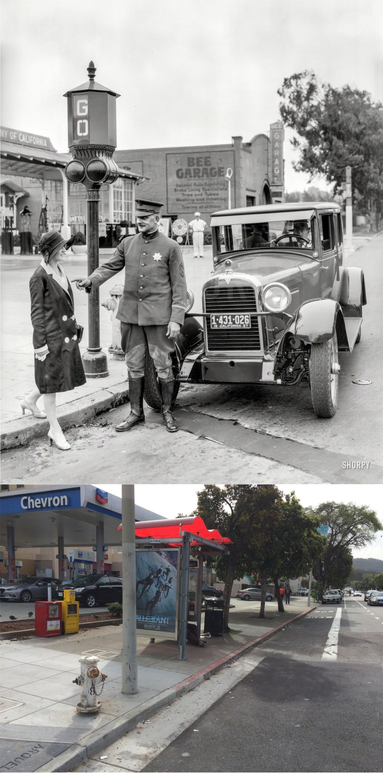 The opposite view shows the service station that was at this corner in 1927. The David Rumsey aerial photo from 1938, available for viewing on the San Francisco Main Library History Room site, clearly shows the gas station at this corner eleven years later. There’s still a service station there today!
  Now to the other side of Golden Gate Park and the Sunset District: Built in 1928, and seen here in 1959, the Parkside Theater building at 19th Avenue and Taraval Street has survived, but it’s now the Parkside Preschool building. I wanted to stop in for a quick one at the Ye Olde Spinning Wheel, but alas, it’s now something called Copy Circle. (Tom Gray)
 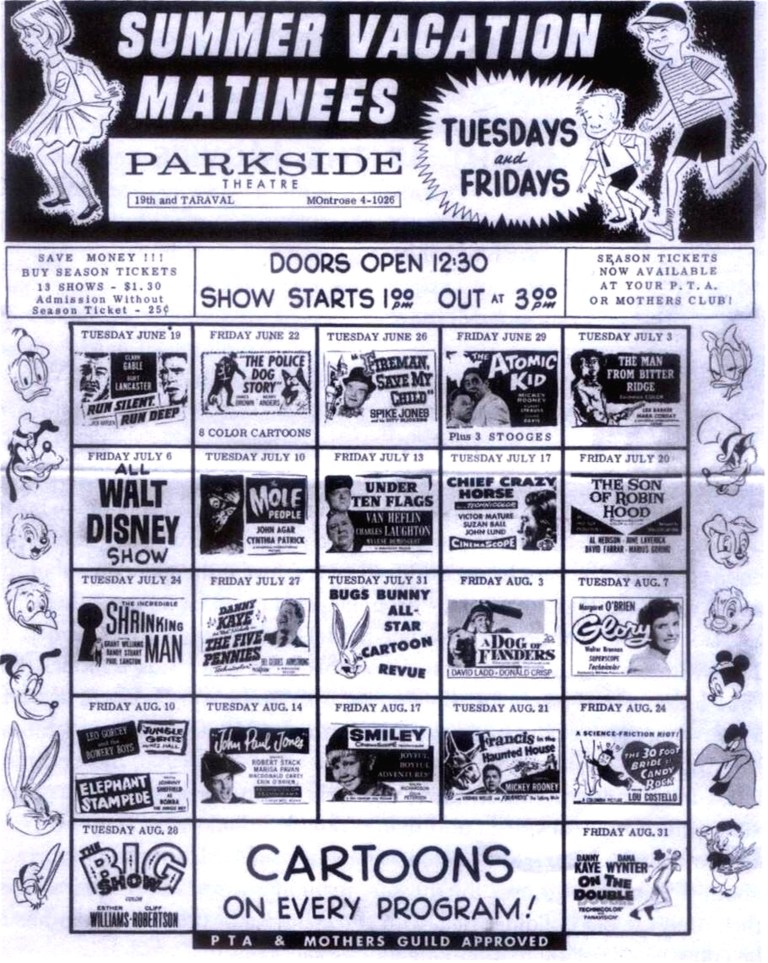 The 1962 Summer schedule for the old Parkside Theater. Clark Gable, Burt Lancaster, Danny Kaye, Walt Disney, Charles Laughton, Robert Stack, Mickey Rooney, the Three Stooges, Lou Costello, Bugs Bunny, and Margaret O’Brien! Margaret’s, kind of, surrounded by men, but she’s got ‘The 30 Foot Bride of Candy Rock’ to protect her!
 St. Cecilia’s Church nearing completion in 1956: “Cecilia, you’re breaking my heart!” I’m, probably, not the only one who has sang that while visiting here. This beautiful church sits on a hill at 17th and Vincente, and can be seen for miles as you approach.
  38th Avenue, between Wawona and Yorba in the 1950’s: Well, he’s not the only one with a bike like that. (Robert Menist)
 Nuestra Senora de Guadalupe at Broadway and Mason in the 1920’s: I had a profound religious experience here. The climb to get to this church felt like halfway to Heaven!
 City Hall, circa 1915: Now that has to be the homeliest blimp I’ve ever seen! The Main San Francisco Library now occupies the spot on the left where the building with the Durham Tobacco ad was.
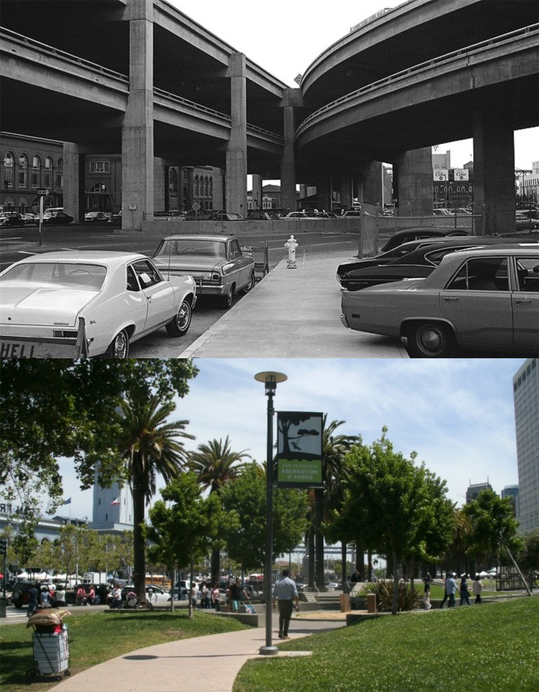 There are people who will tell you that the Embarcadero Freeway served a purpose, and that they miss it. Just pass by them slowly, and say a prayer for them. The sign at the lower left of the vintage picture looks like it reads “HELL”, but it wasn’t that bad!
  Military discipline at the Presidio in the 1930’s was tough!
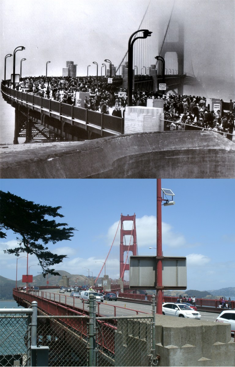 “Pedestrian Day” traffic at the opening of the Golden Gate Bridge, May 27, 1937:
 The old Playland-at-the-Beach Rollercoaster was where the tan condominiums are to day.
 Built in 1907, and moved to Playland-at-the-Beach, then known as Chutes at the Beach in 1913, the Playland merry go round thrilled kids and parents alike until the park closed in 1972. Moms still wave to their kids today on the Playland Merry-go-round relocated to Fourth & Howard Streets in Downtown San Francisco.
 It sure was pretty last Sunday up on Twin Peaks! It’s nice to know that you can still see the Bay Bridge from here like you could in the 1950’s.
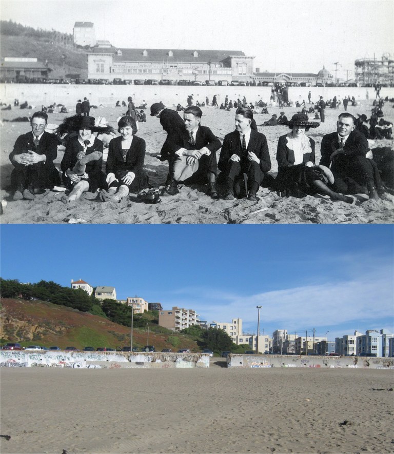 A day at the beach: The building behind them on the Great Highway would later become Topsy’s Roost. (Marilyn Blaisdell)
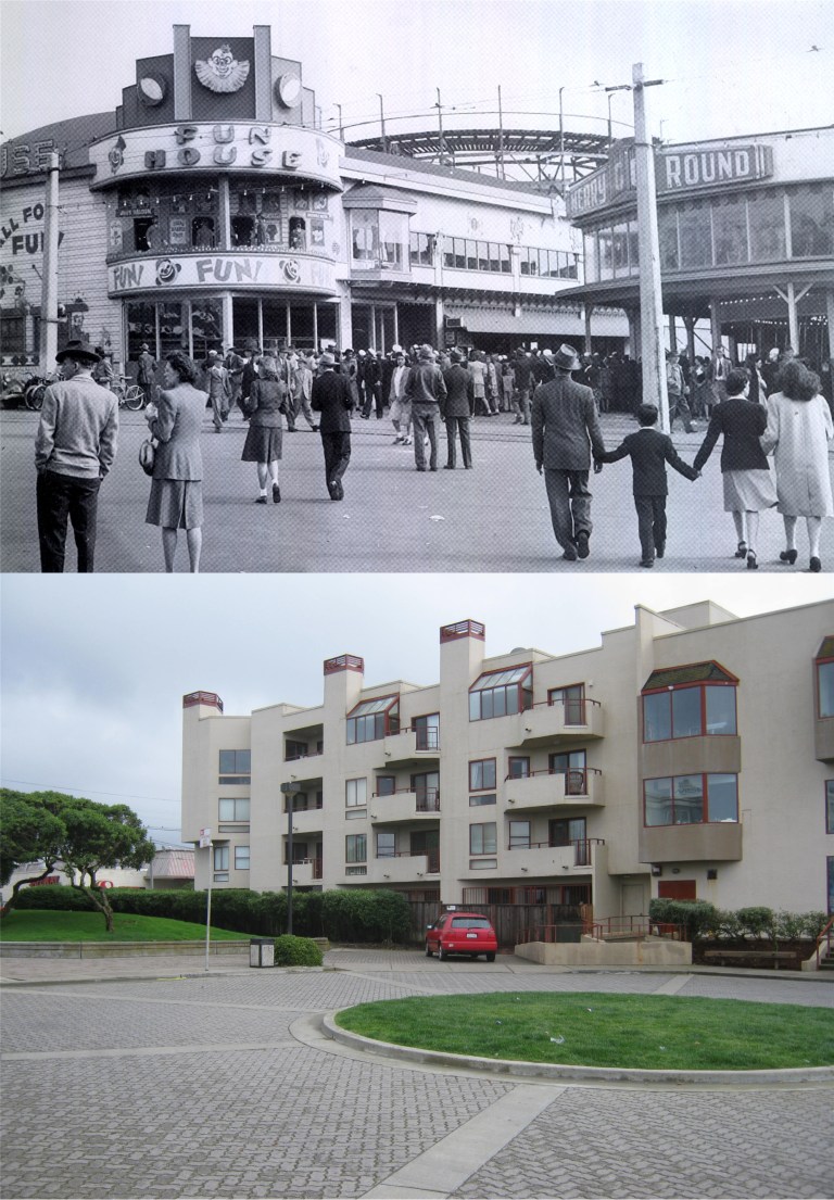 The Funhouse at Playland-at-the-Beach in the 1940’s: The Funhouse was where the condo and grass embankment are today. (Marilyn Blaisdell)
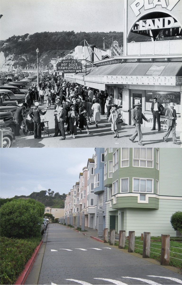 A busy day at Playland-at-the-Beach during World War Two: The ‘It’ sign in the background was where It’s It ice cream sandwiches were invented. You can still buy them today, and they’re still just as good. (Marilyn Blaisdell)
 1902 – The Statue of Benjamin Franklin in Washington Square: After the 1906 Earthquake, Bennie was moved to the center of the square in the shade. You know how fussy he was! The guy on the far right in the old photo is saying, “Hey, she’s checking me out!” The guy next to him is saying, “She is not, she’s checking me out!” The third guy from the right is saying, “You’re both wrong, she’s checking me out!” The two guys on the left of the statue are saying, “Look, she’s checking me out!” “No she isn’t, she’s checking me out!” The lady across from them is saying, “These guys are giving me the creeps! I wish they’d stop looking at me!”
  1942 – The KSFO broadcasting crew at their station and tower on Islais Creek during World War ll. Although, talk show format now, KSFO played the popular music the baby boomers folks loved in the 1950’s, 1960’s and 1970’s, and it’s theme song. ‘Sound of the City’ was rated one of the most beautiful station identification commercials in the country in the1960’s. Click on the link below. Although fenced off, the art deco building and broadcasting tower are still at Islais Creek today.
 “The Crookedest Street in the World.” It’s a nice Jigsaw Puzzle picture, but cable cars don’t run on Leavenworth at the bottom, only Hyde at the top, and I don’t think that the residents on Lombard are that happy to see tourists.
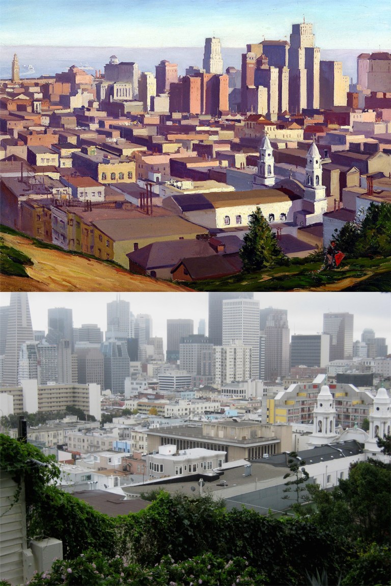 A Downtown San Francisco painting of long ago from Ina Coolbrith Park: Legend has it that Russian Hill got its name when the early 49ers discovered the graves of seven Russian sailors while they explored the hill.
 Hyde at Union in the 1950’s:
 Three views of cable cars on the “Hyde Street Grip” near Francisco Street:

 Hyde at Greenwich on Russian Hill in 1949: The girl at the front of the cable car in the vintage picture looks like Carole Lombard, but she was gone by then. (Mercer Photos)
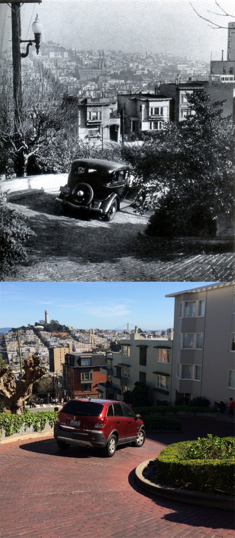 A visit to Russian Hill wouldn’t be complete without a drive down “the Crookedest Street in the World”, either in 2016 or in 1939. You can just make out Coit Tower to the right of the streetlamp in the vintage photo.
 Telegraph Hill in the 1940’s (Gabriel Moulin Studios):
 The crest of Telegraph Hill before Coit Tower:
 The, rather, neglected area seen in the 1920’s that would become today’s Pioneer Park behind Coit Tower: (Bancroft Library)
 The view of the Bay in 1927 from where the entrance to Coit Tower is now: (Dept. of Public Works)
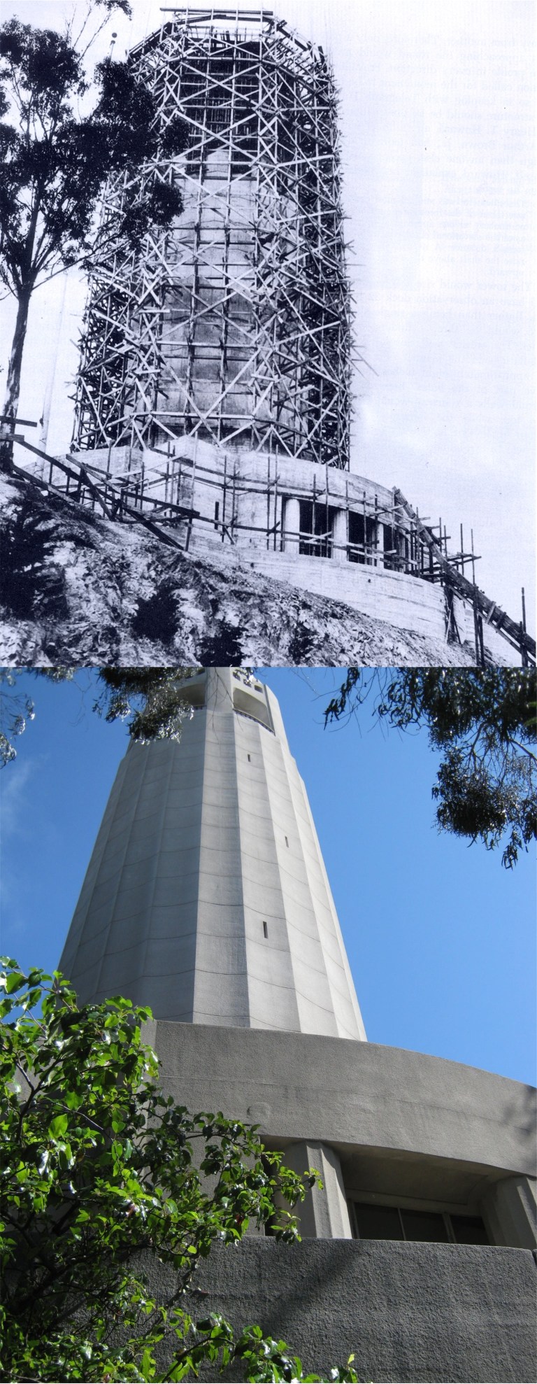 Coit Tower under construction in 1933, and the finished Product today: I’ve got no complaints. (San Francisco Examiner)
 The northwest view from Coit Tower before the Golden Gate Bridge was built.
 A couple Civil War era belles, (“Take that Southern-belle simper off your face, Scarlett!”) watching a ship pass by in the Bay from Calhoun Terrace. They would have been somewhere behind where those houses are today. (Bancroft Library)
 Calhoun Terrace in the 1940’s: A lot of movie scenes have been filmed here, including ‘Vertigo’ and ‘The Days of Wine and Roses’ and right across the street from where I’m at was Michael Douglas’s pad in the TV show ‘The Streets of San Francisco’.
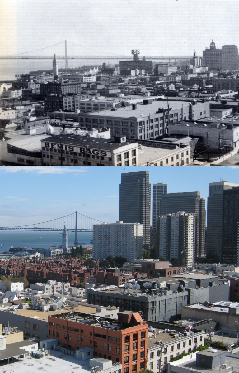 The view from Calhoun Terrace in 1955: Sometimes, I’ll find myself standing in the exact same spot that the photographer of the vintage picture stood long ago. I’ll wonder to myself, “Who was the person? What was he or she like? What was going on in their world at the time? Did this person look out at the view and reflect on the moment as deeply as I do sometimes?”
 Pier 23 from Telegraph Hill in 1939: That’s the Treasure Island World’s Fair with its Sun Tower across the Bay.
  The dedication of the Columbus Statue in the Coit Tower parking lot in October of 1957: The view is from the top of the tower. (San Francisco History Center)
 Kearny Street coming down to Broadway in 1971: Another moment of reflection for Carol Doda, who died in 2015.
 One the best pictures of the old gingerbread Cliff House I’ve seen! There’s something contemporary about the old picture even though it had to be taken before 1907 when that Cliff House burned down.
  The Dirty Dozen, minus one. I have no idea what military outfit these guys represented at the Ferry Building just after the 1906 Earthquake. This picture shows the damage done to the building.
  A Shorpy picture from the 1920’s at City Hall. My friend, film historian and author Mark Vieira, pointed out to me that the church in the far right of the old shot is the St. Paulus Lutheran Church on Eddy Street at Gough that burned down in 1995. This church can be seen in the films ‘Greed’, ‘Vertigo’ and ‘The Man Who Cheated Himself’.
  Historic Jackson Square at Montgomery and Jackson Streets: These buildings survived the 1906 Earthquake because of their brick and iron construction. At the far right in the old picture was the Montgomery Block Building, (the Monkey Block) at 628 Montgomery Street. Built in 1853. Tt was a favorite hangout for poets and authors the likes of Jack London, Bret Harte, and Mark Twain. The building was demolished in 1959, and the Transamerica Pyramid Building occupies the spot today.
 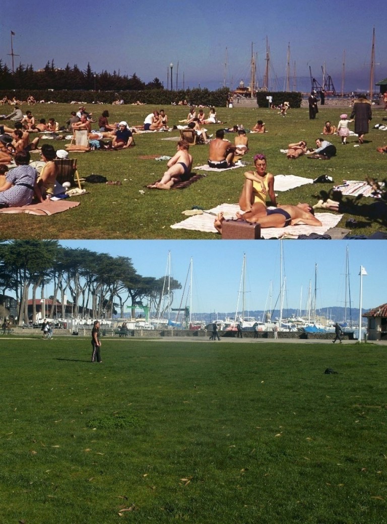 “Hardbodies” of the summer of 1940: This shocking display of skin was at the west side of the Marina Yacht Harbor seen below this winter. The old stone lighthouse can be seen in the background of both pictures. (Cushman Collection)
 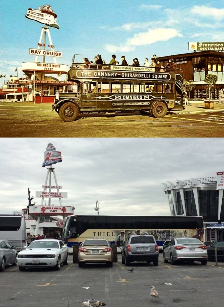 The Ghirardelli Omnibus Tour of Fisherman’s Wharf was very popular in the 1960’s, and was even featured in an episode of the television show ‘I Spy’ starring Robert Culp and Bill Cosby!
  The main pedestrian walkway from Haight-Ashbury into Golden Gate Park goes through the old Alvord Bridge Tunnel built in 1889. Everybody, from George Harrison to Timothy Leary walked through this tunnel to get to ‘Hippie Hill’.
  The Grateful Dead house, 710 Ashbury Street: I see Jerry Garcia, but the caption says that Janis Joplin and members of the Jefferson Airplane are in the photo too. You’ll have to have keener eyes than mine to spot them.
 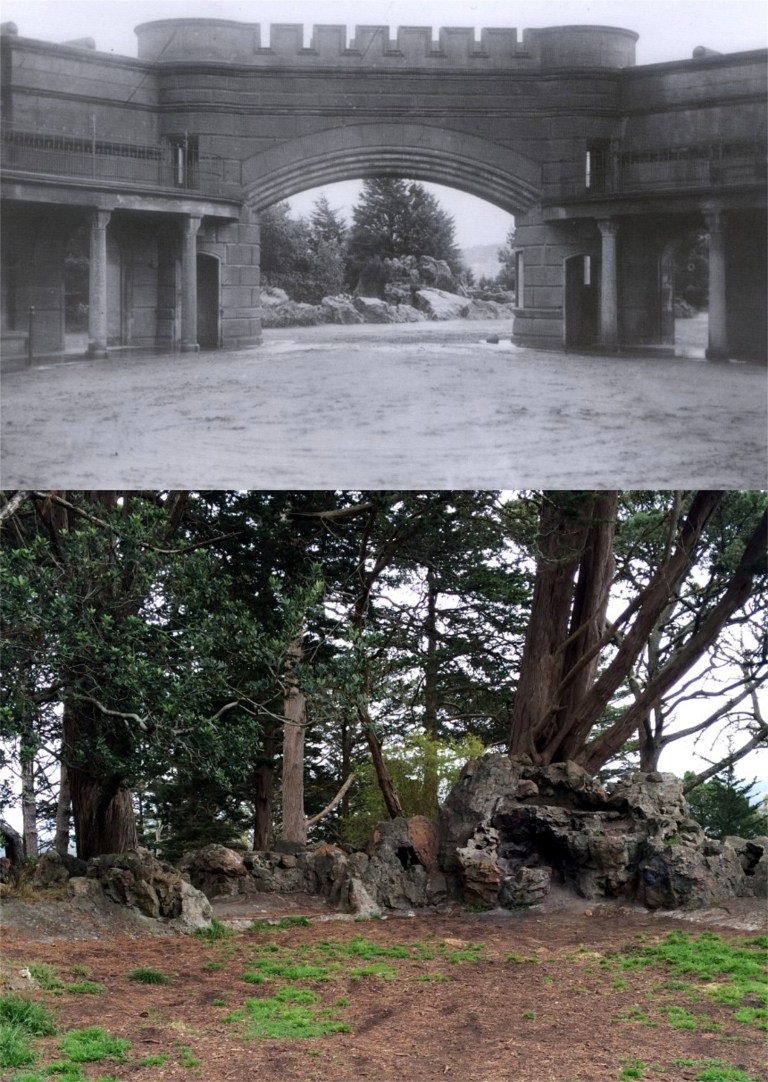 In 1891, Sweeney’s Observatory opened up on top of Strawberry Hill at Stowe Lake in Golden Gate Park, and was popular at the time for its panoramic views. The observatory crumbled in the 1906 Earthquake, and this is all that’s left of the building today.
 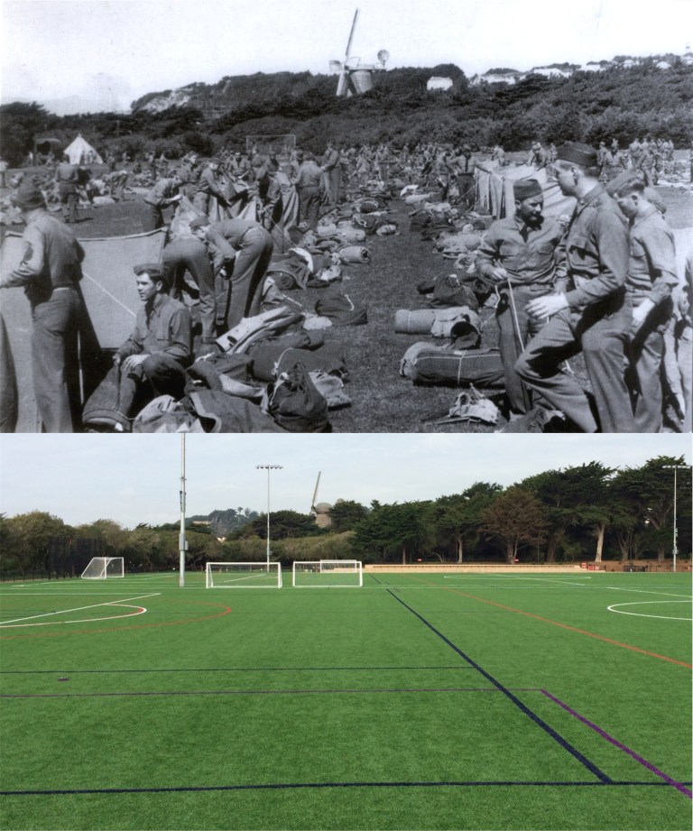 The 78th Coast Artillery camping out behind the Beach Chalet in Golden Gate Park in October of 1941. They would be awful busy defending the West Coast two months later. This Area is now the renovated Soccer Fields. (San Francisco Public Labrary)
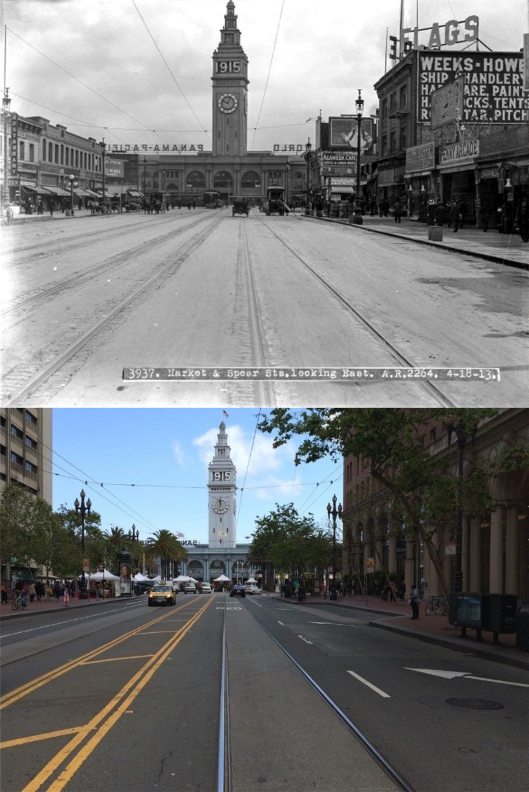 Yesterday, San Francisco was once again “Everybody’s favorite city,” Now that the Super Bowl is over things will get back to normal, and, hopefully, most visitors will leave with nice memories of the City. This was the spot where Super Bowl City was held seen in 1915, and in 2015. You’ll be able to walk through this area again without having to go through security check points, although, they did a wonderful job and kept everybody safe.
  You’ll be able to drive through the financial district again like you could in the 1920’s
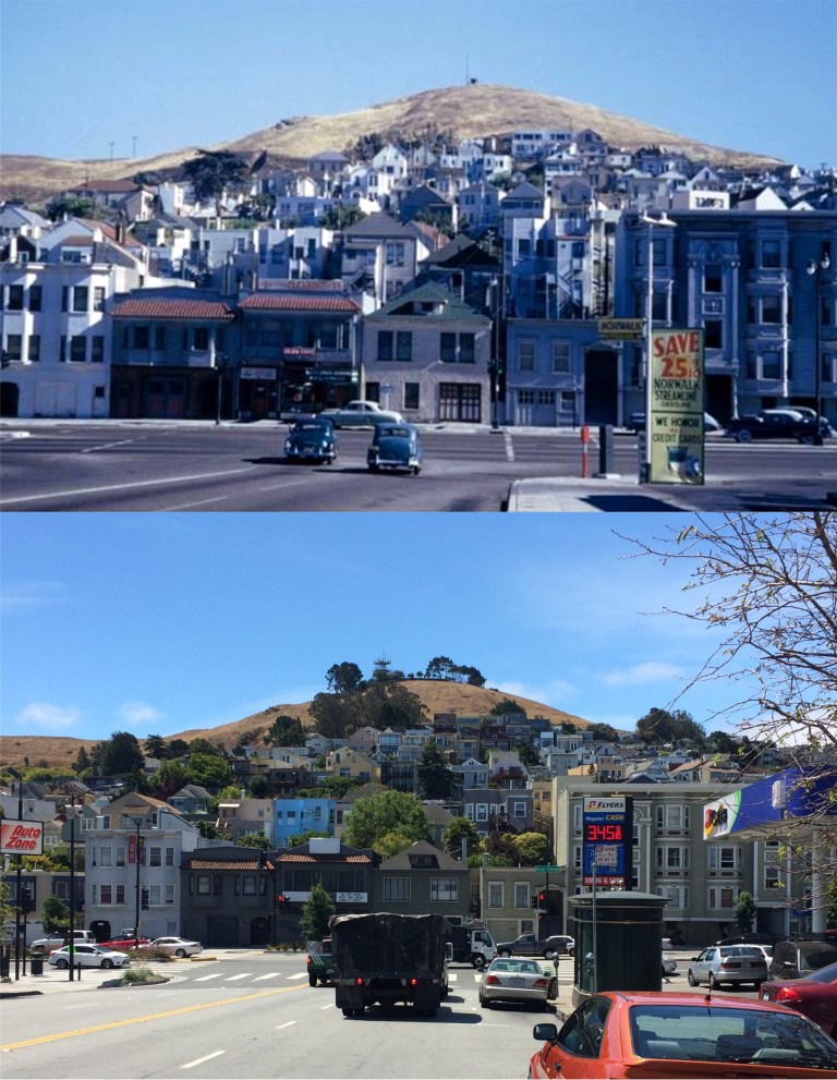 In the shadow of Bernal Heights: Unfortunately, gas prices will never be back to normal in San Francisco, regardless. (The Cushman Collection)
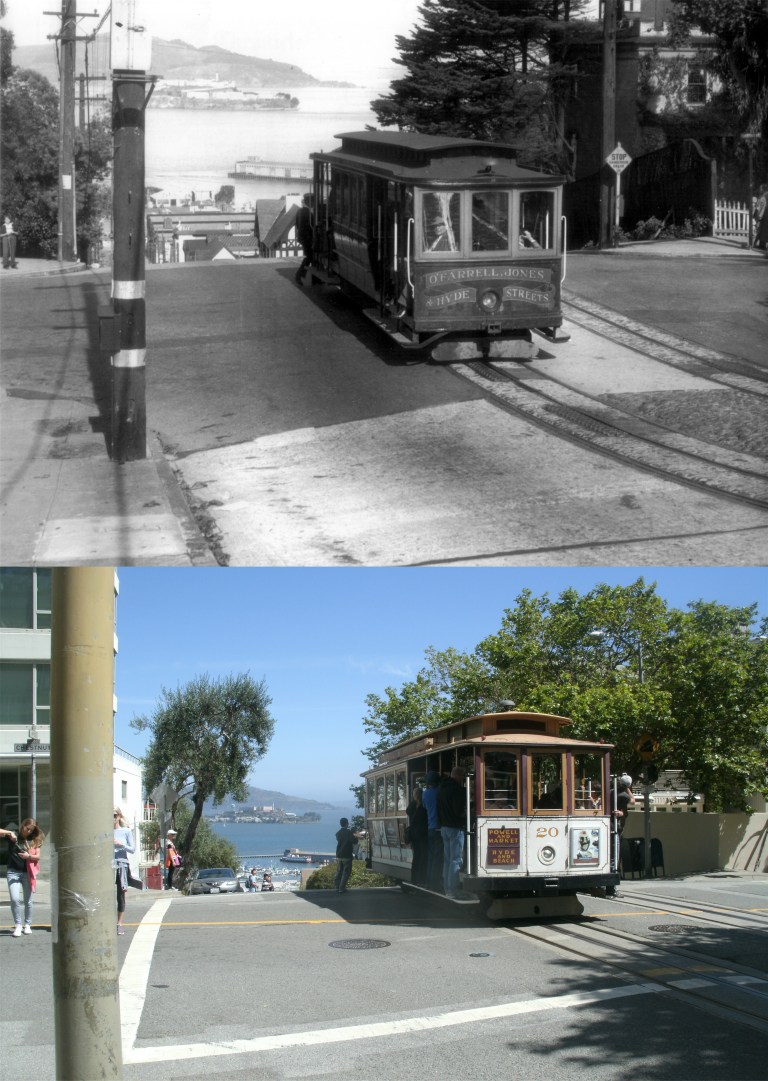 On the “Hyde Street Grip” cable cars will still climb “halfway to the stars” as normal. That’s the old O’Farrell line coming up Hyde.
 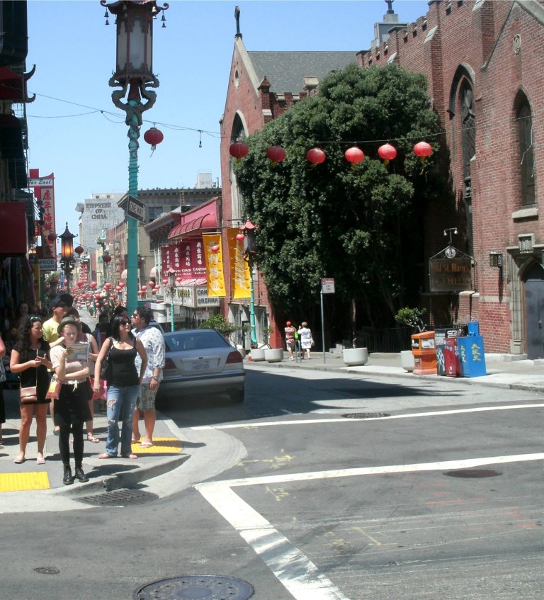 And something that’s always normal; the interesting scenery you pass by when riding on a cable car!
 It’s been damaged by two major earthquakes, eaten by a giant octopus, and, probably, appeared in more motion pictures than any other building in the United States except for the Capitol Building in Washington and the Los Angeles City Hall Building. The Ferry Building is a survivor, and, easily, the “Grande Dame” of San Francisco. (Vintage photo California Historical Society)
 Two aerial views of the Ferry Building: The top one is in her hey day showing many of the ferry slips, and below, a rare shot of the Embarcadero Freeway under construction. (Bancroft Library)
 Repair work in 1907 on the Ferry Building, damaged in the 1906 Earthquake. Things seem to be getting back to normal with encouraging signs like, “Open For Business” and “San Francisco Will Do it.” That black smoke in the background is from a ferryboat, either arriving or leaving. I don’t think those things would pass emission testing today. (Vintage photo San Francisco Maritime National Historical Park)
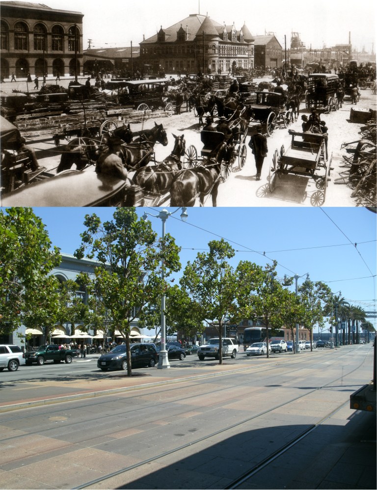 The southern wing of the Ferry Building on a busy day in 1907:
 Another terrific and one of the oldest postcards of San Francisco I’ve seen; the Embarcadero from the Ferry Building tower when it was still called East Street. That’s Telegraph Hill on the left, and Alcatraz out in the Bay.
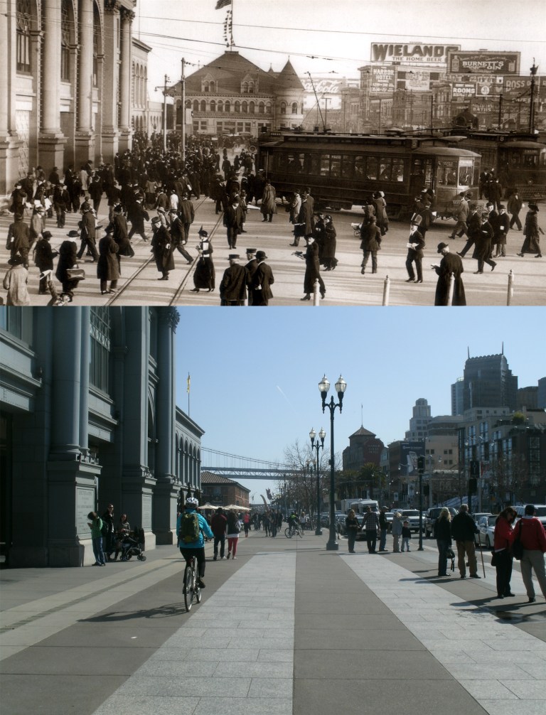 At the foot of the Ferry Building looking south in 1915: (Vintage photo San Francisco Maritime National Historical Park)
 The Ferry Building from the south in 1929: Look at that ferryboat traffic! That’s a Coit Towerless Telegraph hill in the vintage photo. (Vintage photo San Francisco Maritime Historic Park)
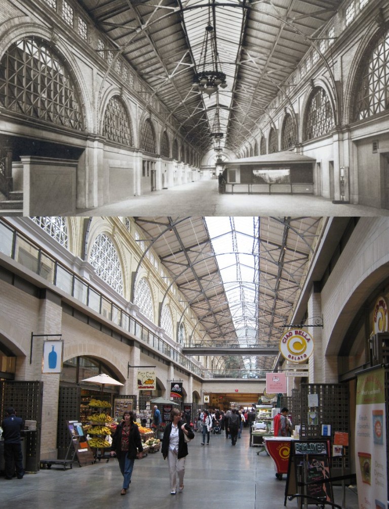 The inside of the Ferry Building in the 1930’s (San Francisco Public Library)
 Interesting Ferry Building history that I recently learned of: The north side of the building had what was called an “apron” that lowered down to the top deck of the arriving ferry boats to allow passengers to enter the Ferry Building into the upper level where they went through a corridor, and crossed over the Embarcadero to Market Street by the footbridge seen in many old photos. (Vintage photo Thomas I. J. Snead)
 The passenger footbridge seen from the Embarcadero: (Marilyn Blaisdell Collection)
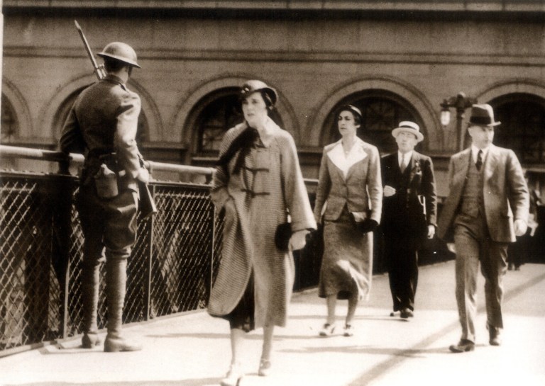 This 1942 photo was taken on the last day of the foot bridge before it was dismantled for salvageable war material. The doughboy soldier was there to symbolize 1918 when the bridge first opened.
 ‘The Falcon in San Francisco’ Oops, wait a minute…… ‘The Falcon in San Francisco’
 The Falcon (Tom Conway) being “kidnapped” by a little girl in front of the Ferry Building: It was, probably a backdrop, but that was the location in the film.
 This strip of shops directly across from the Ferry Building bordered by Market, Mission, Steuart, and the Embarcadero was demolished to make way for the Embarcadero Freeway. Although patronized regularly by ferry boat passengers, this block had developed into a skid row by the 1950’s. The shady palm tree area was where the stretch of buildings stood. This was where the Occupy San Francisco movement camped at the end of 2011. (Vintage photo San Francisco Public Library)
 The Hotel Colchester, just north of the Ferry Building in the 1950’s: Somebody put a lot of artistic effort into that LAUNdRY sign. Below, is the spot that the glamorous Colchester Hotel occupied. (Vintage photo California Historical Society)
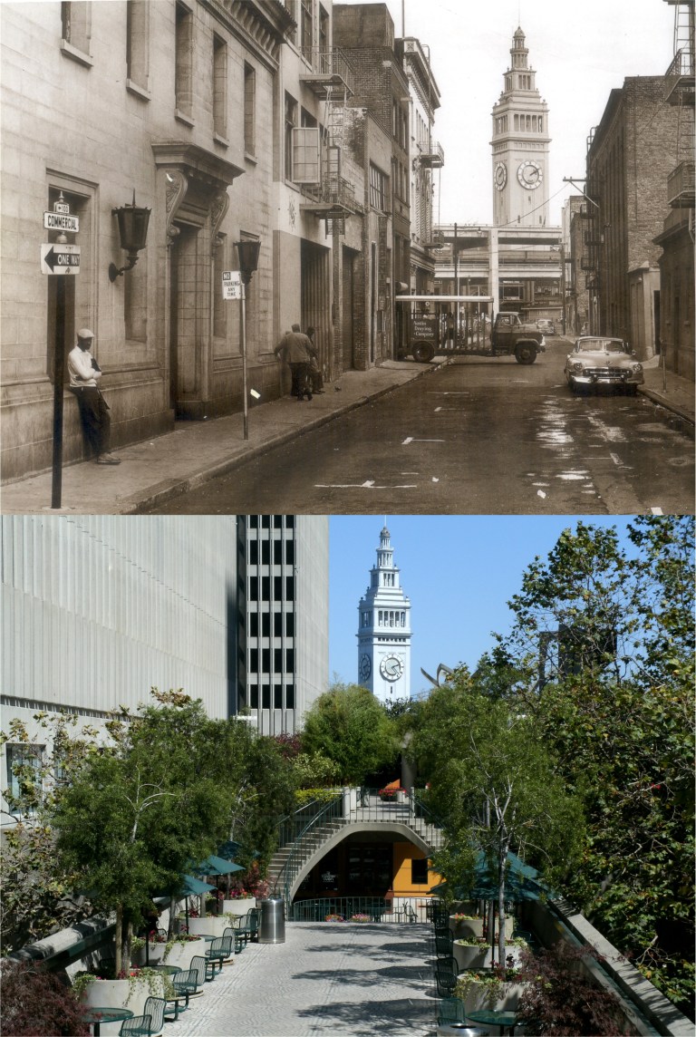 Commercial Street in the 1950’s when it ran through to the Ferry Building. (Vintage photo Karl Kortum)
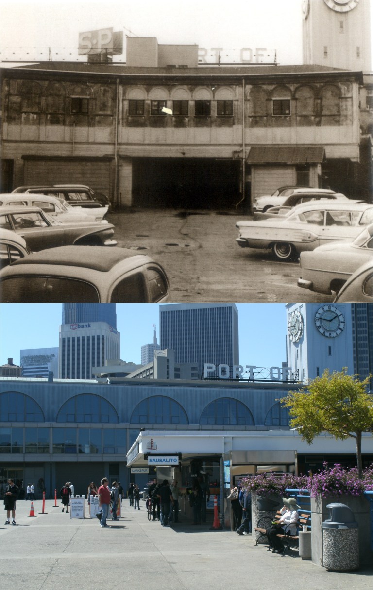 Eventually, the area behind the Ferry Building had become a graveyard of parked 1950’s and 1960’s cars. The Sausalito Ferry launch occupies this location today. (Port of San Francisco Archives)
 Like the people of France toward Marie Antoinette, the people of San Francisco turned on their queen and imprisoned her behind the Embarcadero Freeway in 1959. Boy that’s corny writing! (Vintage photo Darius Aidala)
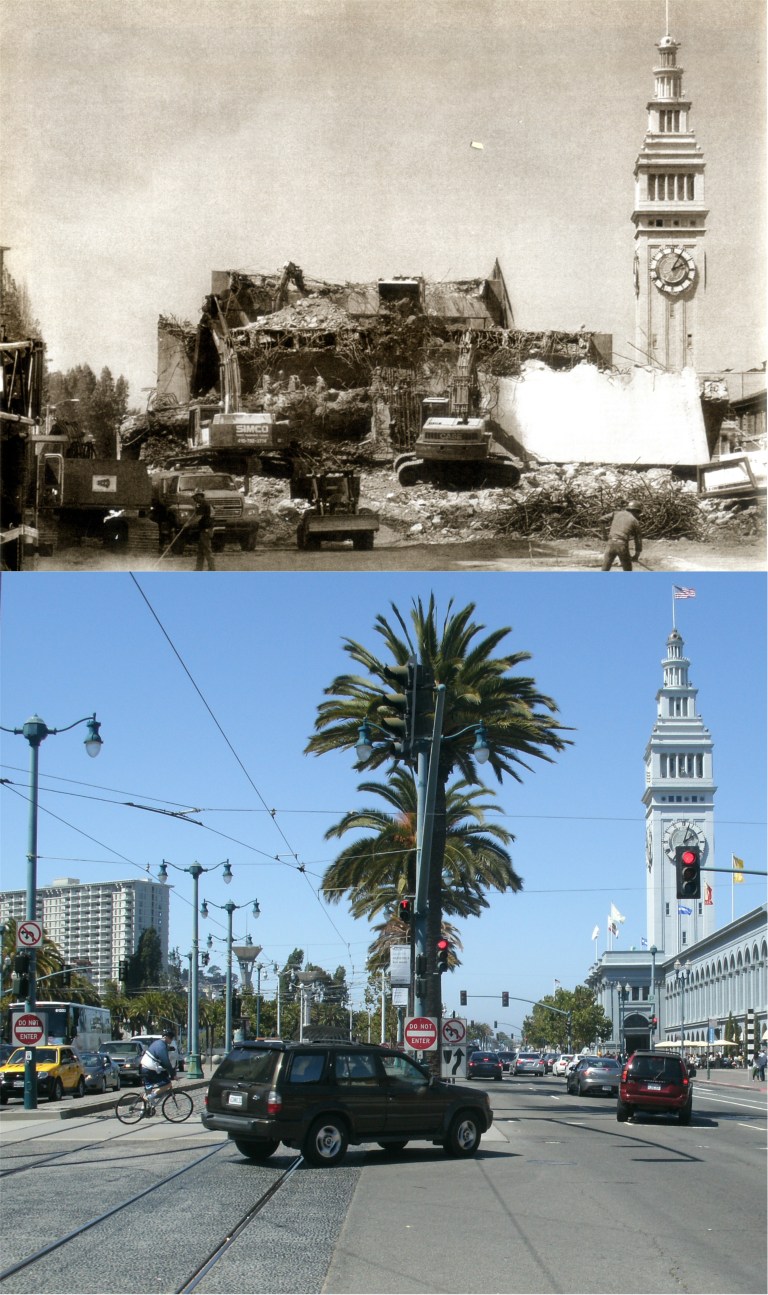 The last of the shabbiness of this area disappeared in 1991 with the demolition of the Embarcadero Freeway due to the Loma Prieta Earthquake of 1989. (Fran Ortiz)