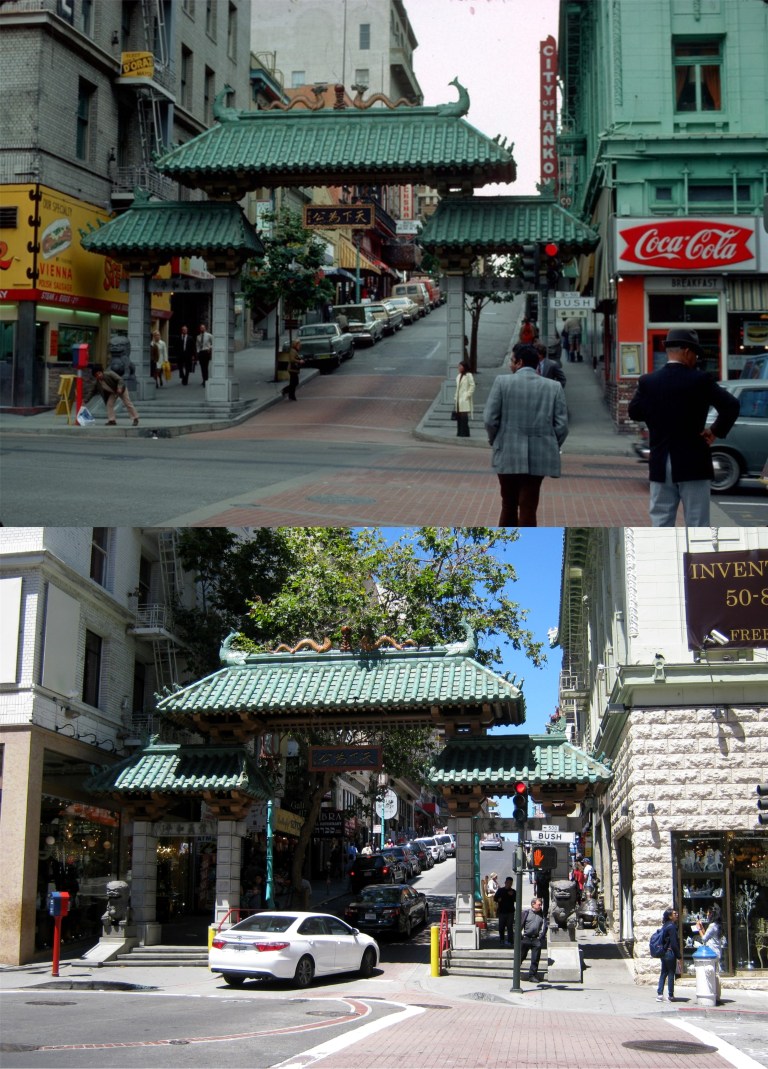
 Lately, to myself, I’ve been referring to my picture taking trips as to being “out in the field”. It sounds a little James Bondian, although, I don’t look like James Bond, and my trips in the field aren’t usually as precarious as Bond’s. Still, I do seem to capture what looks like an occasional SPECTRE agent in some of my pictures. Going out in the field often leads me to Chinatown, as intriguing and mysterious of a place as any Bond has visited. (Peter Stratmoen)
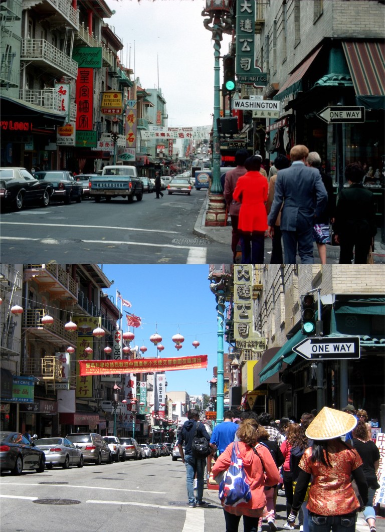 It’s hard to tell the SPECTRE agents from the tourists in Chinatown because it’s so crowded! (Peter Stratmoen)
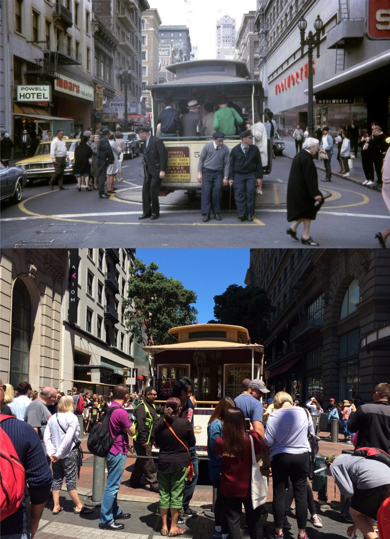 Trips out in the field can bring me to the same place over and over, especially, if it’s one of the most photographed locations in San Francisco like the Powell Street cable car turntable. (The Vintage Everyday site)
 When in the field I regularly scout for out of the way book stores looking for San Francisco lore. Sometimes, I can’t believe what some stores let get away; like two books I recently found. Here, is a 1949 autographed copy of Herb Caen’s most famous work, ‘Baghdad-by-the-Bay’ with its terrific San Francisco Chronicle illustrations like this one of Pacific Street when it was the International Settlement. Was it really like that?
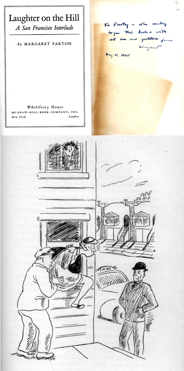 Also, another find is a book that I just recently learned about, ‘Laughter on the Hill’ by Margaret Parton with wonderful 1940’s style drawings. Margaret writes about a year she spent in San Francisco just before Pearl Harbor, and although her adventures are often banal by today’s standards, she, obviously, loves San Francisco, and her colorful descriptions of the City during this period are a delight to read. The inscription from Margaret herself reads, “To Dorothy – who really began this book – with all love and gratitude from Margaret.” May 21, 1945. That taxi driver in the cartoon certainly is giving Margaret a helping hand!
 Being out in the field would be a lot easier if I moved into San Francisco. Here’s a nice place! I’ll just knock on the door and see what they want for it. That’s the Haas-Lilienthal House at California and Franklin Streets then and now.
 Powell Street near Ellis: When morning trips in the field take me to this area, there’s a place right across the street from where you’re looking called Tad’s Steak House serving delicious and modestly priced breakfasts. I try to plan as many trips in the field around this area as possible. (Vintage picture from Randy Shaw’s book ‘The Tenderloin’)
 Being out in the field in Golden Gate Park can sometimes involve an encounter with an apparent offspring of ‘Kronos’, the “Planet Robber” from outer space!
 Trips out in the field usually involve stepping into the past, and no place is this more vivid than the ever changing – never changing Market Street. The building on the right would later become the Emporium and is now Bloomingdale’s. The domed Humboldt Building is still there, and right behind that is a good look at what the Call Building, a survivor of the 1906 Earthquake and Fire, used to look like before its crown was removed and it was remodeled in 1938. The Call Building, now called the Central Tower, is the brown and white striped building behind the Humboldt Building.
 Well, James Bond himself out in the field at Fisherman’s Wharf! Hey, 007, let me give you a trade secret when out in the field here; try the Blackened Red Snapper at the Grotto. (A View to a Kill)

 A Pyramid scheme; The Transamerica Pyramid on the way up in 1971: (SF Images)
 A poet on Telegraph Hill; Allen Ginsberg’s partner, Peter Orlovsky on Vallejo Street: (Howard Greenberg Gallery)
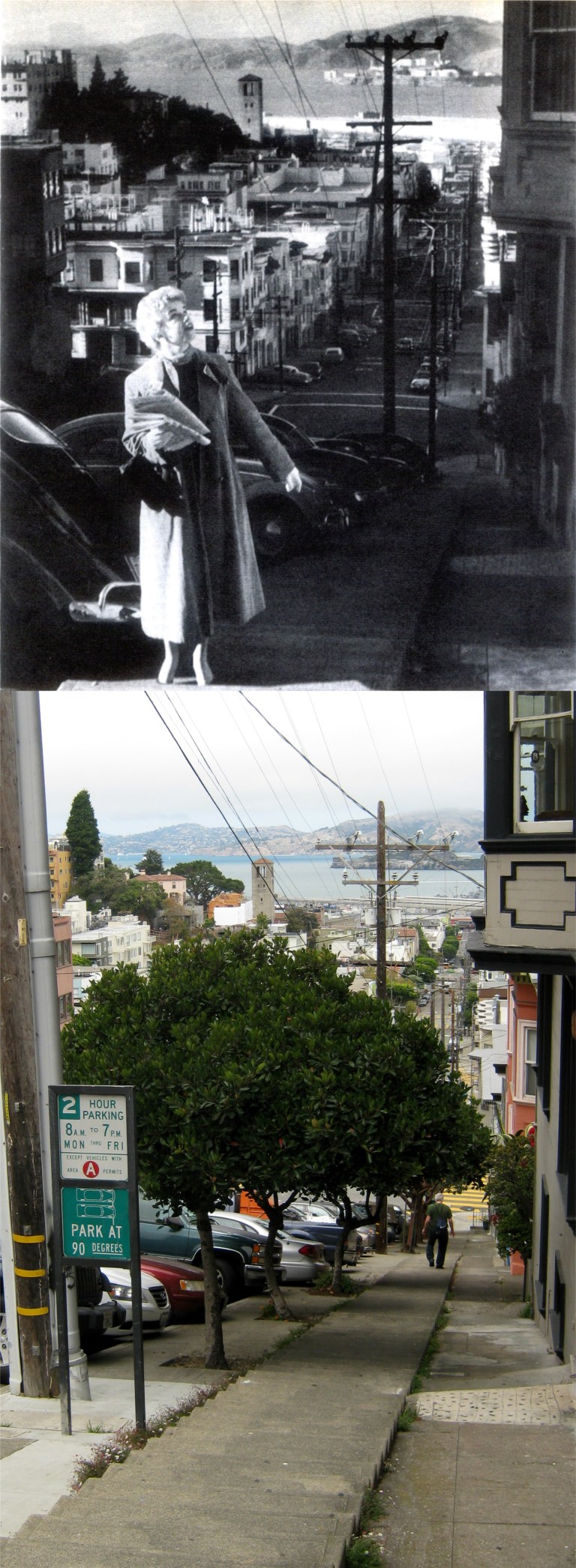
 California Street up from Stockton Street in the 1950’s: This is a redo that I went back for; it’s too nice of an old picture to not try to get as close as possible. (vintage everyday)
 Police activity at the Cliff House in 1958, and police activity at the Cliff House yesterday: Click on the link below for some more police action in a series of pictures I did called ‘Cops” in May of 2015.
 Speaking of the Cliff House, this was how it looked in the early 1970’s. How cool was that; although, I would have got seasick looking at it! The totem pole farther down the street is still there.
 The Tenderloin is certainly the most depressing neighborhood of San Francisco. Bounded by Mason on the east, Van Ness on the west, Geary, on the north, and Market Street on the South, it has one of the highest crime rates in San Francisco, and the sidewalks are filled with homeless people, many of who are far beyond any help. Still, there are some great vintage pictures from the area to do comparisons on. We’ll start here at 645 Larkin Street in 1961. (Vintage San Francisco Library photo from the Huffingtonpost.com)
  Manuel’s Steakhouse at Turk and Leavenworth looked good. Looks like the early 60’s. The Market and Deli sign on the corner is the old 288 Club neon sign. (Vintage San Francisco Library photo from the Huffington.com)
 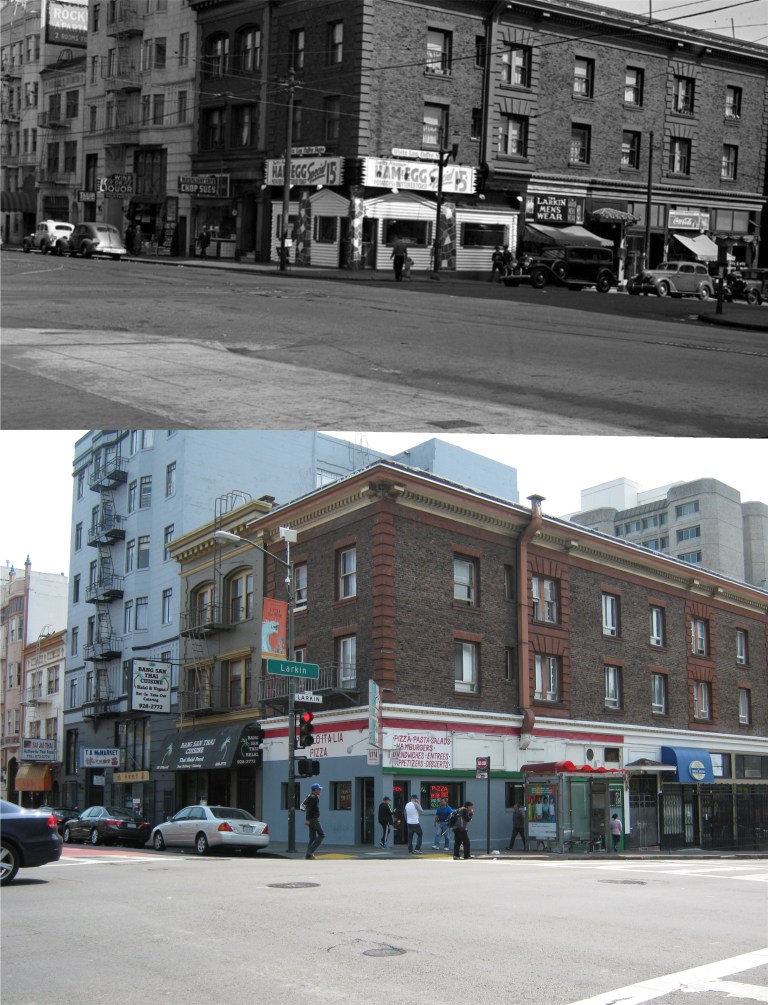 Larkin and O’Farrell Streets in 1939:
 A fender bender at the Shawmut Hotel on O’Farrell near Jones in 1941: The Shawmut is now the Crosby Hotel. (Vintage San Francisco Library photo from the Huffingtonpost.com)
  The Golden Gate Theater on the corner of Golden Gate Avenue and Taylor Street showing the 1956 movie ‘The Conqueror’: This movie has a notorious legacy; it was filmed in the Utah desert near an above ground nuclear test site, and ninety one people involved with the filming contracted cancer afterward, many who died of the disease, including John Wayne, Susan Hayward, Agnes Moorehead, and Director Dick Powell.
  Eddy and Taylor Streets, 1963: Aw, another lovely eyesore gone forever! Well, at least the fire hydrant survived. (Vintage San Francisco Library photo from the Huffingtonpost.com)
  Jones and Eddy Streets in 1962: The corner restaurant serving Chinese food is now the Tenderloin Police Station. (Vintage San Francisco Library photo from the Huffingtonpost.com)
 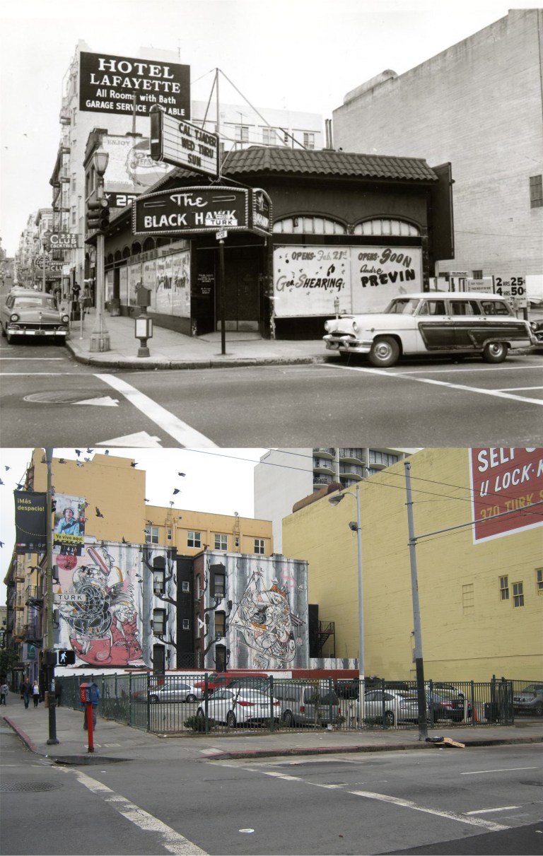 Hyde and Turk Streets, 1961: It would have been a great comparison if the Black Hawk Club was still there, but “Alas, alack, and Alaska” it isn’t. Andre Previn performed here!!! (Vintage San Francisco Library photo from the Huffingtonpost.com)
  The opposite view from the previous photo of the Black Hawk Club looking down Hyde Street in 1961: The tall building in the background is the old Empire Hotel building. (Vintage San Francisco Library photo from the Huffingtonpost.com)
 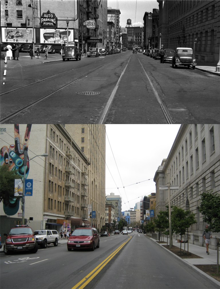 Looking down McAllister toward Market from Hyde in the 1939: The building on the right is the Federal Building. (Vintage San Francisco Library photo from the Huffingtonpost.com)
  86 Golden Gate Avenue in 1964: Unfortunately, this is part of life in the Tenderloin. Maybe someday long after I’m gone someone will do a then and now of my photo and write, “Can you imagine when it was like that?” (Vintage San Francisco Library photo from the Huffingtonpost.com)
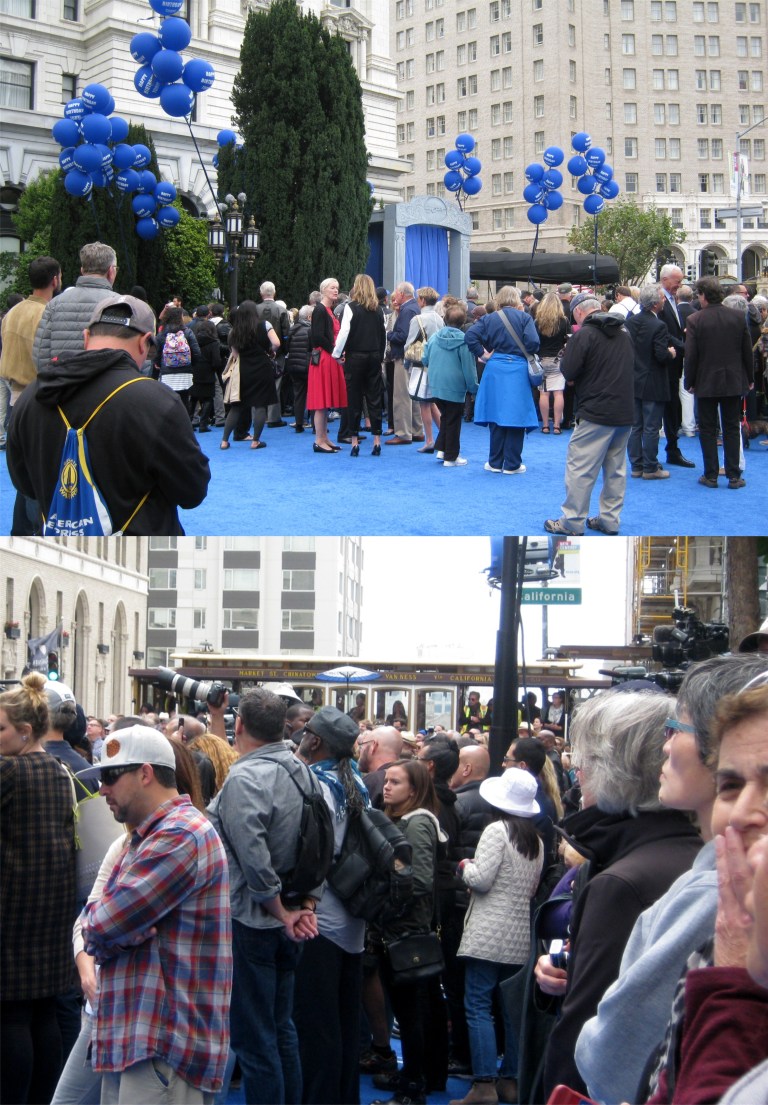 Fifty Five years ago this December, Tony Bennett first sang ‘I Left My Heart in San Francisco’ in the Fairmont Hotel’s Venetian Room. The Fairmont honored the occasion today with the unveiling of a statue of the singer who recently celebrated his 90th birthday. On hand were former San Francisco mayors Dianne Feinstein and Willie Brown, Nancy Pelosi, and Tony Bennett himself. A passing California Street cable car stopped for the ceremony and the conductor played ‘I Left My heart in San Francisco’ on the cable car bell.
  After a mist of imitation San Francisco fog for effect, the statue was unveiled. Click on the You Tube link below to see Tony Bennett singing a version of his signature song in July of 1963 to somebody else pretty special.
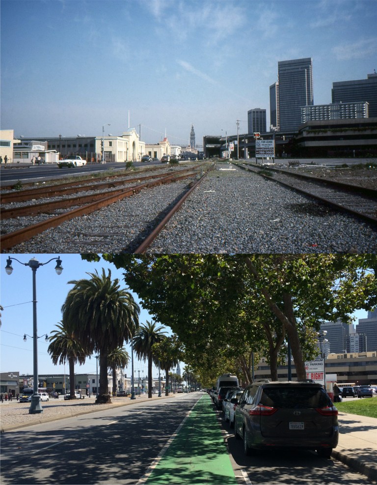 These are updates of slides I took in San Francisco in the 1980s when slide photography was popular. Gawd, I’m doing then and nows on my own pictures! If I didn’t already feel old…….. This view is of the Embarcadero near Broadway and the old Belt Line railroad tracks in May of 1983: This is an area that has changed drastically since 1983. You can see part of the building the Exploritorium moved into on the left. Nice Thunderbird!
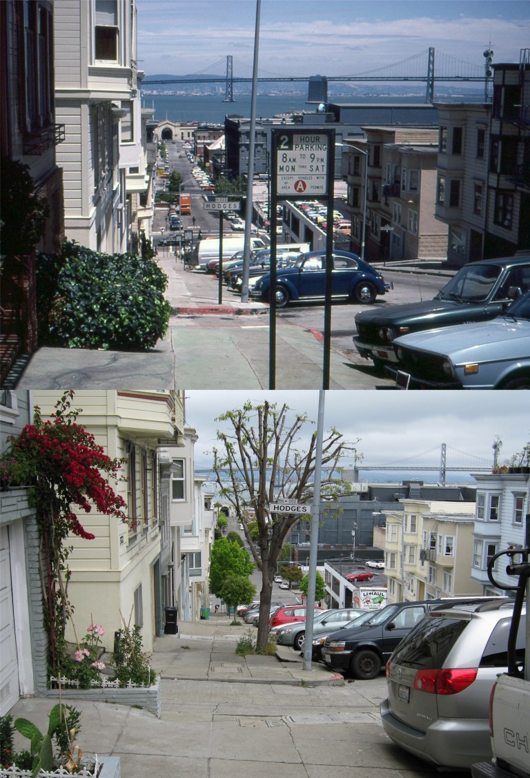 This view is looking down Vallejo Street on Telegraph Hill in May of 1983: “Slug bug!” That’s a game we used to play when we were kids; the first person to spot a Volkswagen would hit the person they were with on the arm. I was nearsighted so I was never very good at it.
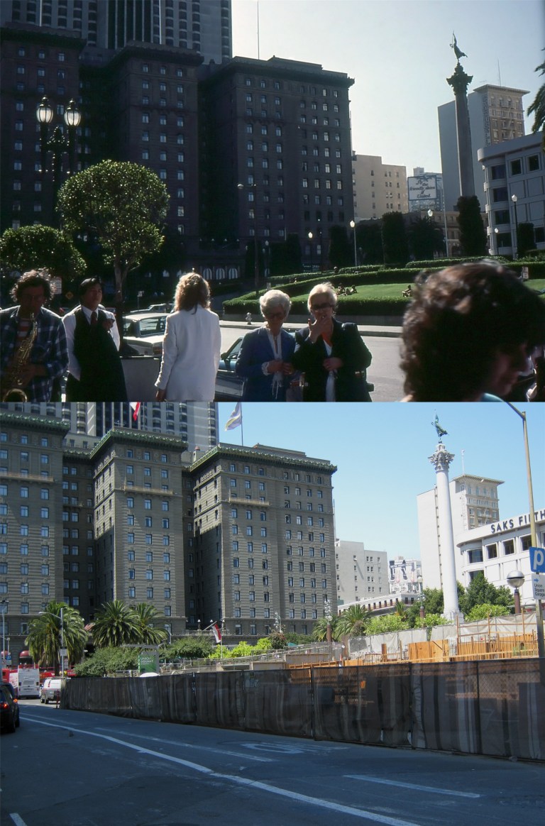 Union Square when it had grass looking toward the St. Francis in May 1983: I wonder who those ladies photo bombing me were! Hey, lady, put out that cigarette!
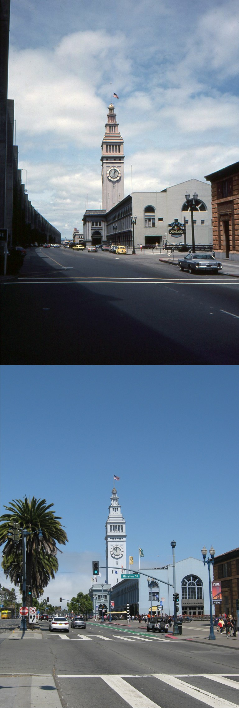 Mission Street at the Embarcadero in May of 1983: That’s the Embarcadero Freeway on the left. Sinbad’s Restaurant was finally forced to close this year. They sure liked to save paint on their crosswalks back then. “Slug bug!”
 Harrison at the Embarcadero in May of 1983: Look how run down it was back then! The opening of AT&T Park really did a lot for this area.There’s the Embarcadero Freeway again. You can just barely see the Ferry Building in the new shot. The old Hill’s Brothers Coffee Building is on the left.
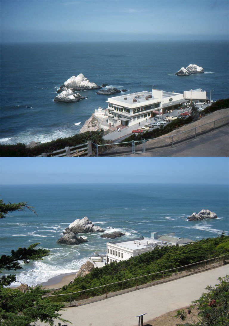 Ah, the Cliff House that I liked best in August of 1983; and back when it could still be seen from Sutro Heights:
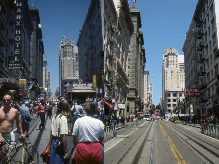 Powell Street looking up Nob Hill: This was taken in June of 1984, the day that the cable cars were placed back in service after a two year shutdown for repairs.
 Looking down Commercial Street toward the Ferry Building in August of 1983: KABL Radio! I remember that station! That’s the one we turned off because we thought it was for old people, and I like that kind of music now! “Slug bug!”
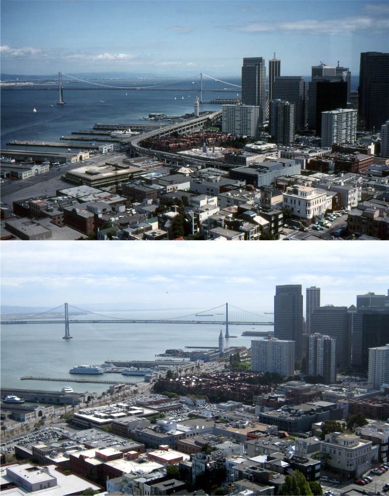 The view of the waterfront from Coit Tower in May of 1983: Not too different now, except for the absence of the Embarcadero Freeway, and the pier that used to run out to the Bay Bridge tower that could not exist today because of 9/11.
 Pier 39, Alcatraz, and Angel Island from Coit Tower in May of 1983: I must have taken my picture from the same Coit Tower window as I did in 1983.
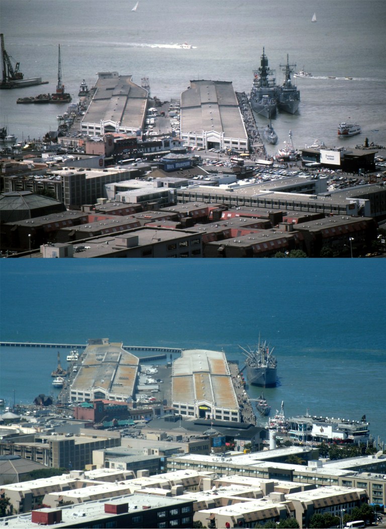 Fisherman’s Wharf from Coit Tower in May of 1986: The World War Two submarine Pampanito is still tied up at Pier 45, but the Liberty Ship Jeremiah O’Brien is tied up behind her today. I don’t know what the two ships behind her in 1986 were. The Wax Museum sign is long gone.
 Market Street at Eighth St. in September of 1985: Looks pretty close today. They were just starting to run the old trolleys about then, you can see one in both pictures. The Orpheum Theater has a new sign now, but I couldn’t get it in my picture. Click on the link below for a collection of pictures I posted in November of 2014 on the classic ‘A Trip Down Market Street’ from 1906. The old film began about here.
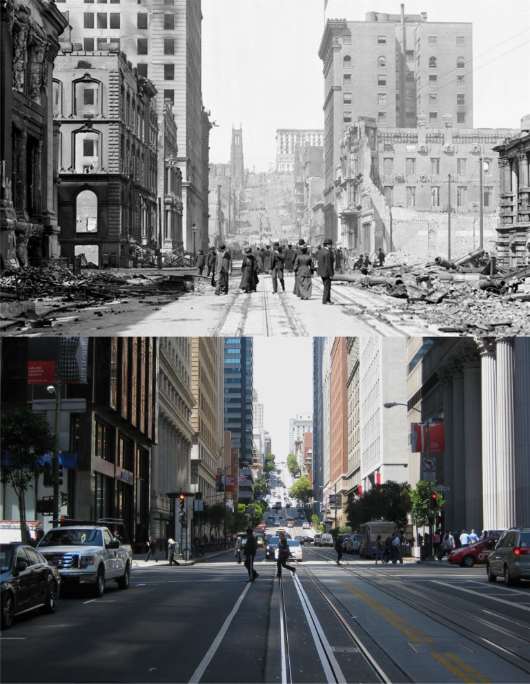 No, this post isn’t about people searching for survivors after the disaster; it’s about buildings or landmarks, seen here in pictures from the earthquake, that have survived to this day. We’ll start at California and Sansome Streets looking up Nob Hill. There’s actually two survivors seen here, first being the California Street cable car tracks. The cable car line has been running along California Street for one hundred and thirty eight years! Second is the Fairmont Hotel at the top of Nob Hill on the right. You can still see part of the hotel, although somewhat lost in the sunshine, today. Notice the church near the top of Nob Hill on the left in the old photo. This was the Grace Episcopal Church on the corner of California and Stockton Streets. There’s more about this church in the next picture. (Vintage photo Atlantic Magazine)
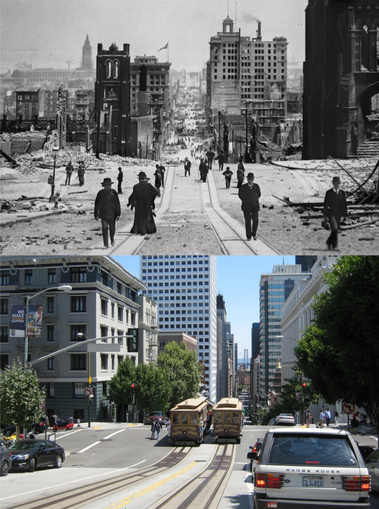 Old St. Mary’s Church on the left side of California Street, and Grace Church at the corner of Stockton Street on the right: The old photo is looking down California Street just up from Stockton Street, a reverse direction from the previous photo. You can’t see Old St. Mary’s too clear from this spot anymore, and not at all from between the cable car tracks like the old picture, but it’s still there. This is as far out into the street you can go before losing sight of it, and you take a chance at being run over by a car or a cable car! The church can be seen just above the cable car on the left, and it’s still a great place to light a candle for a loved one or, like me, rest your feet awhile when you’re tired of walking around San Francisco. Grace Church on the right did not survive the disaster, and was rebuilt on top of Nob Hill. Now known as Grace Cathedral, it’s one of the most beautiful churches in San Francisco. (Vintage photo Atlantic Magazine)
 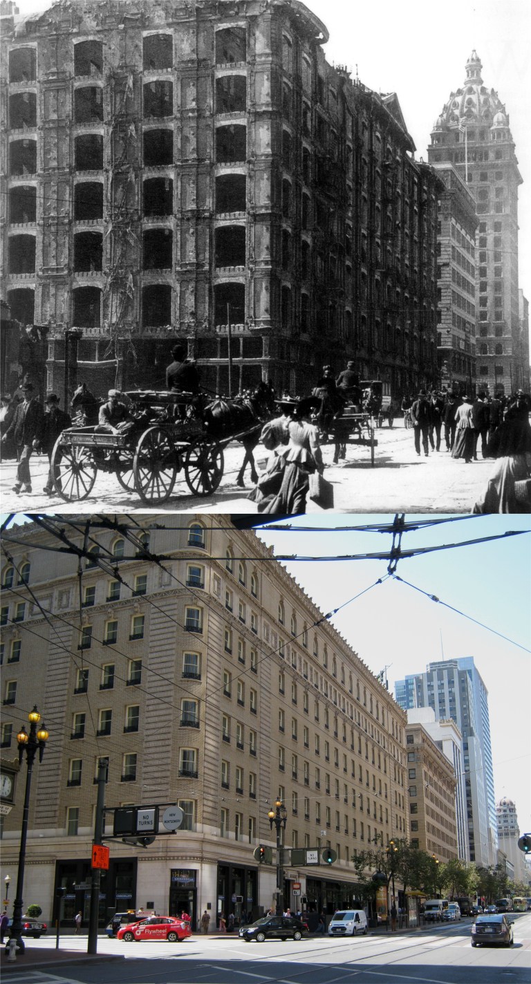 The Palace Hotel, the grandest hotel west of the Mississippi, survived the earthquake in relatively good shape, but was completely burned down by the fires after the quake. Although another Palace Hotel is there today, and as fine a hotel as any in San Francisco, it was completely rebuilt so it doesn’t count as a survivor. What is a true survivor is the crown topped Call Building behind the Palace Hotel. It survived the earthquake and fire, although heavily damaged, and was a major part of the San Francisco skyline for years after. In the late 1930’s, some nitwit with power decided to remove the dome at the top and remodel the facade of the building. It’s now called the Central Tower. (Vintage photo San Francisco History Center)
  One block west from the Palace Hotel is where 3rd Street runs into Market. On the right is the bottom of the Call Building, what it looked like in 1906, and what it looks like today after the 1930’s remodeling. On the left is the Hearst Building of publisher William Randolph Hearst, the inspiration for Orson Welles movie ‘Citizen Kane’. Hearst wasn’t about to let an act of God or nature take anything away from him, so he had the building completely rebuilt. It’s still known as the Hearst Building today, see the H above the door in the modern picture, but it’s really a survivor in name only. (Vintage photo Atlantic Magazine)
 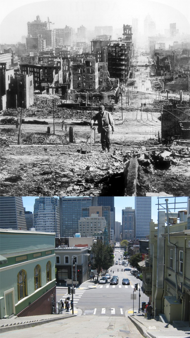 Kearny Street, up from Broadway: Just down Kearny behind the man in the old photo you’ll see the diagonal cut of Columbus Avenue. On the corner you’ll see a building that was under construction when the Earthquake hit. This is the Sentinel Building, also known as Columbus Tower, and it’s still there today; it’s the green, white, and gold building in the center. (Vintage photo San Francisco History Center)
 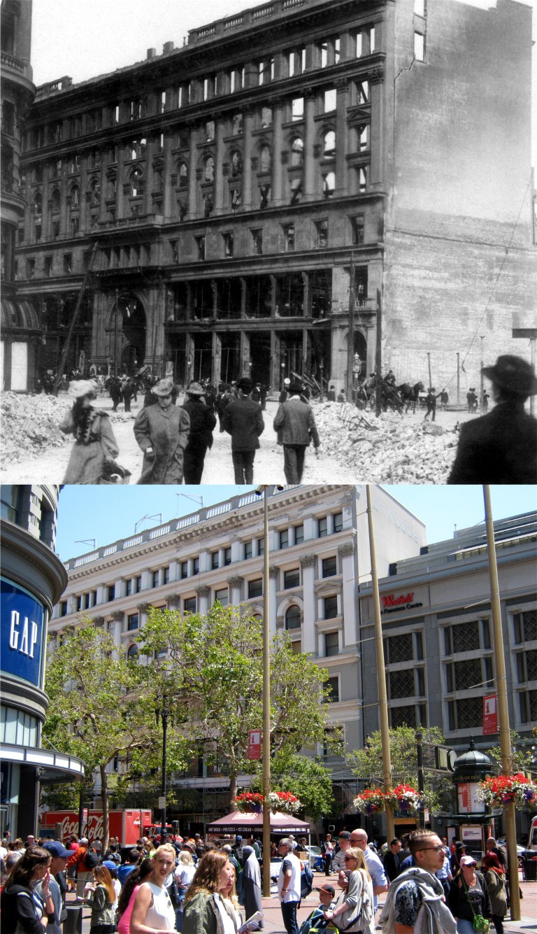 Powell and Market Streets; two survivors here: On the left is a small portion of the Flood Building. You’ll see more on this one in the next picture. In the center is the front of the old Emporium Building across Market Street from Powell. Although heavily damaged, by the earthquake and fire, enough of the structure survived for rebuilding, and is now Bloomingdales. (Vintage photo San Francisco History Center)
 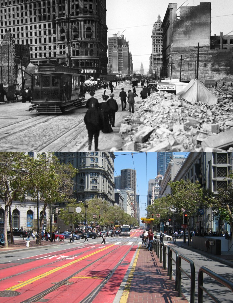 Market at 5th Street looking toward the Flood Building: There’s, actually, six genuine survivors from the old photo today, and you can see them all in my picture. On the corner of Powell and Market Streets, the Flood Building survived the disaster in pretty good shape, and looks almost as it did in 1906. Below it is one of the busiest locations in San Francisco, Hallidie Plaza, and the Powell Street cable car turntable. Next survivor on the right is the Gothic looking building with the red top at 704 Market Street, originally the Mutual Savings Bank Building. Just behind 704 Market Street is the old Chronicle Building with its damaged clock tower. You can just see a piece of the brownish red Chronicle Building minus the clock tower it no longer has behind the Baroque looking 704 Market Street. In the center of Market Street is the Ferry Building. Across Market Street and seen today behind the Humboldt Building is the Call Building. At the far right is the old Emporium Building, now Bloomingdale’s. (Vintage photo Atlantic Magazine)
  The grandest survivor of them all; the Ferry Building seen from the Bay as the fire that destroyed most of San Francisco approaches: The only thing that saved the Ferry Building from burning was the width of East Street, now called the Embarcadero, which was too wide for the fire to jump. (Vintage photo Atlantic Magazine)
 This 1912 panorama from one of the volumes in the History Room at the San Francisco Main Library was taken looking south from Telegraph Hill between Montgomery and Kearny Streets. Development on the hill has made a perfect comparison shot today unavailable, (unless you’re one of the lucky people living in some of the buildings on this side of Telegraph Hill today) so the best I could do was use a composite of two pictures I took from the top of Coit Tower between Montgomery, where the Pyramid Building is, and Kearny, where the dark Bank of America Building is. The pictures sweep from the top of Nob Hill on the right to the downtown business district of San Francisco on the left. The highest spot in the vintage photo is of the Fairmont Hotel on the top of Nob Hill. You can see it from my picture behind the Fairmont Tower built in the 1960’s. The building with the cupola and white stripes near the center of the picture is the Sentinel Building also known as the Columbus Tower. You can still see it from much higher up in my picture. Speaking of cupolas, this building is owned by film director Francis Ford Coppola! The large building with the arches to the left and behind of Columbus Tower was the old Hall of Justice Building on Kearny. This building was the setting of many films and at least two television shows, ‘The Lineup’ (San Francisco Beat) and ‘Ironside’. It was demolished for the Hilton Hotel in 1967. Trivia note, the swimming pool on top of this Hilton was where “Scorpio” shot the girl in the opening of the 1971 film ‘Dirty Harry’. The area of smaller buildings between the Fairmont Hotel and the Columbus Tower is Chinatown. None of the surviving buildings on the far left can be seen from here today because of the downtown skyscraper boom that began in the 1960’s.
 I wonder how many people remember what that’s from. These are vintage photographs of San Francisco from the History Room at the San Francisco Main Library taken not long after the 1906 Earthquake and Fire destroyed the city. They certainly go WABAC, I mean, way back. Here is Market Street and Kearny in 1910. On the left is Lotta’s Fountain, placed here in 1875, and the old Chronicle Building. That’s the brand new Palace Hotel on the right. The previous Palace Hotel was completely destroyed by the 1906 fire.
 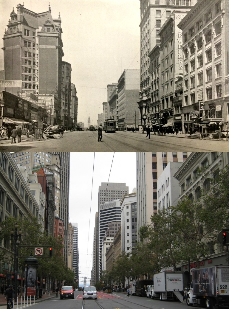 One block west from the previous picture at Market Street and Grant Avenue in 1910: The Gothic style roof of 704 Market Street can still be seen on the left. The Palace Hotel is farther down on the right. At the foot of Market Street in this and the preceding picture is the beloved Ferry Building. There’s some construction work being done on both sides of Market Street, possibly due to the 1906 Earthquake, although, most of the damage from this area had been cleared up by 1910.
  The Sing Fat Building, (No, not the “Fat Lady Sings” Building) on the corner of Grant Avenue and California in Chinatown circa 1907: Notice that the street marker on the left still identifies Grant Avenue as Dupont Street. The street name was changed to Grant Avenue in 1908.
  The Fairmont Hotel on top of Nob Hill in 1910: Looks, kind of, lonely! Herb Caen once called the Fairmont Hotel “Playland-at-the-Beach on the hill.” I’m not sure what he meant by that, (or maybe I’m not grown up enough to understand) but I thought it was a funny line.
  This 1909 picture is, probably, the oldest picture of the current Cliff House I’ve seen. When Adolph Sutro’s gingerbread Cliff House burned down in 1907, this one built in 1909 is basically the same building, after much remodeling, that’s there today.
 Mason, Turk, and Market Streets in 1910: The Mechanics Savings Building on the left and the Flood Building in the far back are still there. I used a picture I took here during the 2014 San Francisco Giants World Series victory parade instead of the one I took today because I thought it made a better comparison. Also, this is 2016, and I hope to be back at this spot again in October for another Giants World Series victory parade. Click on the link below for a series about the Giants I posted in March of 2015 when I originally ran the victory parade picture.
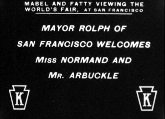
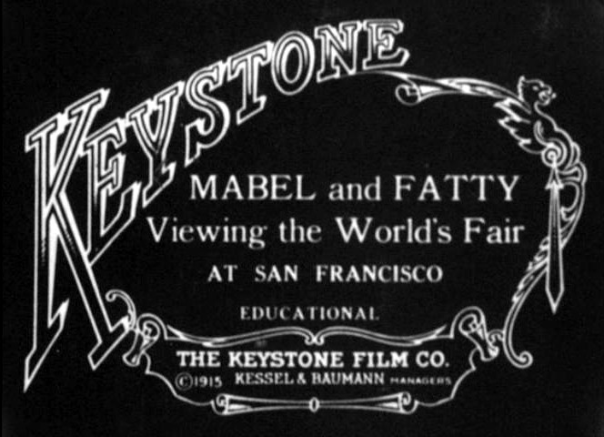 In 1915, Roscoe “Fatty” Arbuckle, and Mabel Normand, two extremely popular stars of a relatively new pastime, going to the “flickers” made two short films in San Francisco. In the more famous of the two they visit the 1915 Panama Pacific Exposition and tour the Downtown San Francisco area.
 The film shows a number of sweeping panoramas including the Fair, the front of the Ferry Building, Union Square, and the City Hall under construction.
  After opening scenes shot at the Fair, the film takes viewers to Downtown San Francisco starting at the Ferry Building, with the original 1915 numbers on the tower that were replicated in 2015.
  After the Ferry Building, the film follows traffic up Market Street.
 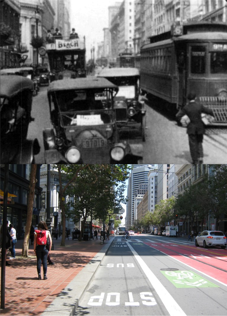 This is at Market Street just up from Grant Avenue. You can still see the columned building on the corner of Grant on the left today, and the building at the right center with the single row of windows, which is the Hearst Building.
  Next on the 1915 tour is the St Francis Hotel and Union Square.
 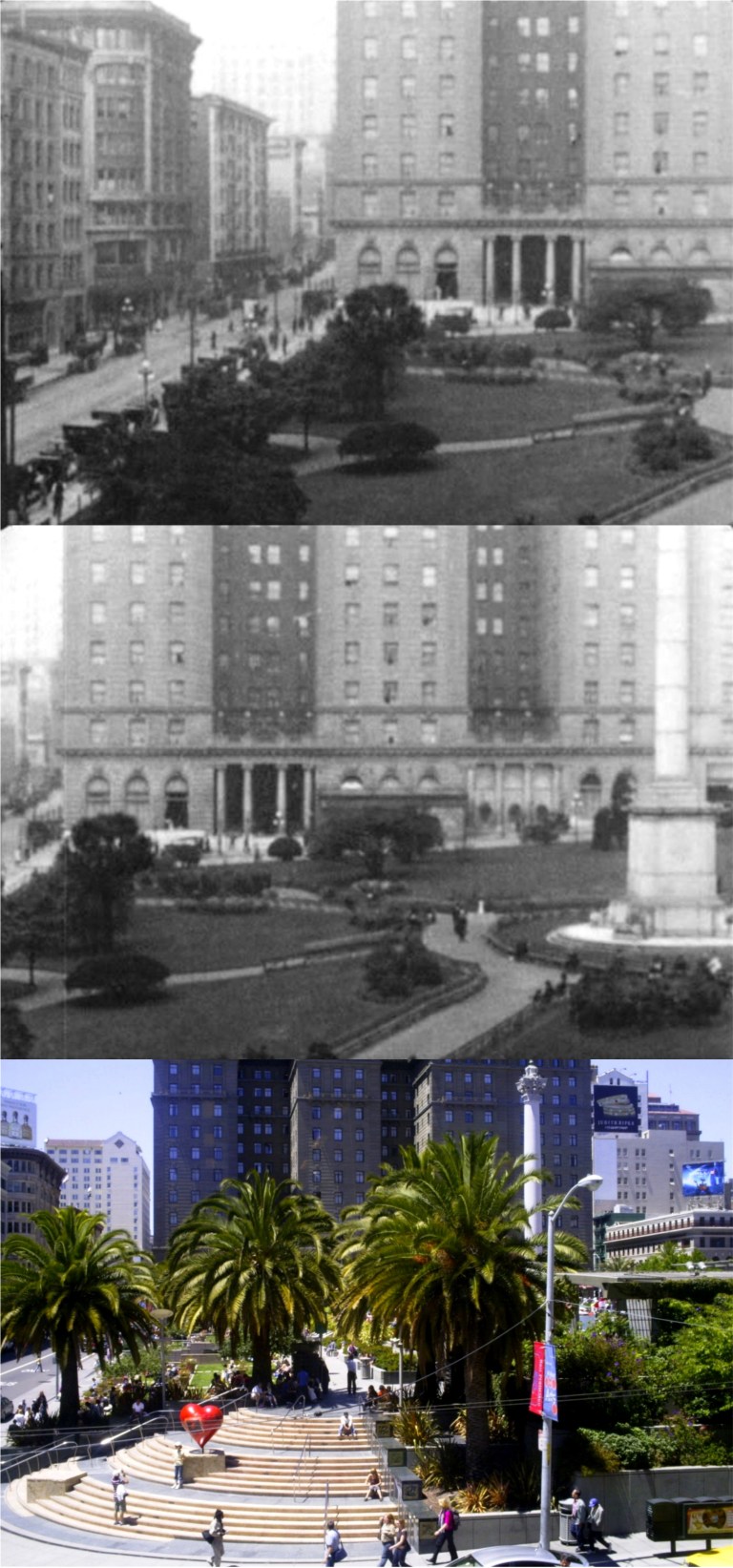 It’s ironic that scenes were filmed here; six years after this short movie was made a scandal at the St. Francis Hotel resulting in three rape trials would put an end to Fatty Arbuckle’s career.
  The film moves to the new City Hall Building, where Mabel and Fatty meet with Mayor “Sunny Jim” Rolph, San Francisco’s longest serving, and probably most popular in his time, mayor.
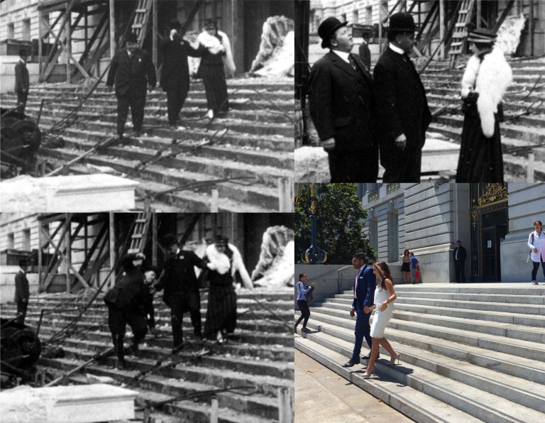 On the steps of City Hall amidst construction debris, Fatty almost slips. I’m not sure if this was acting on his part or a real mishap. The attractive couple in my picture made it down the steps without any problem.
 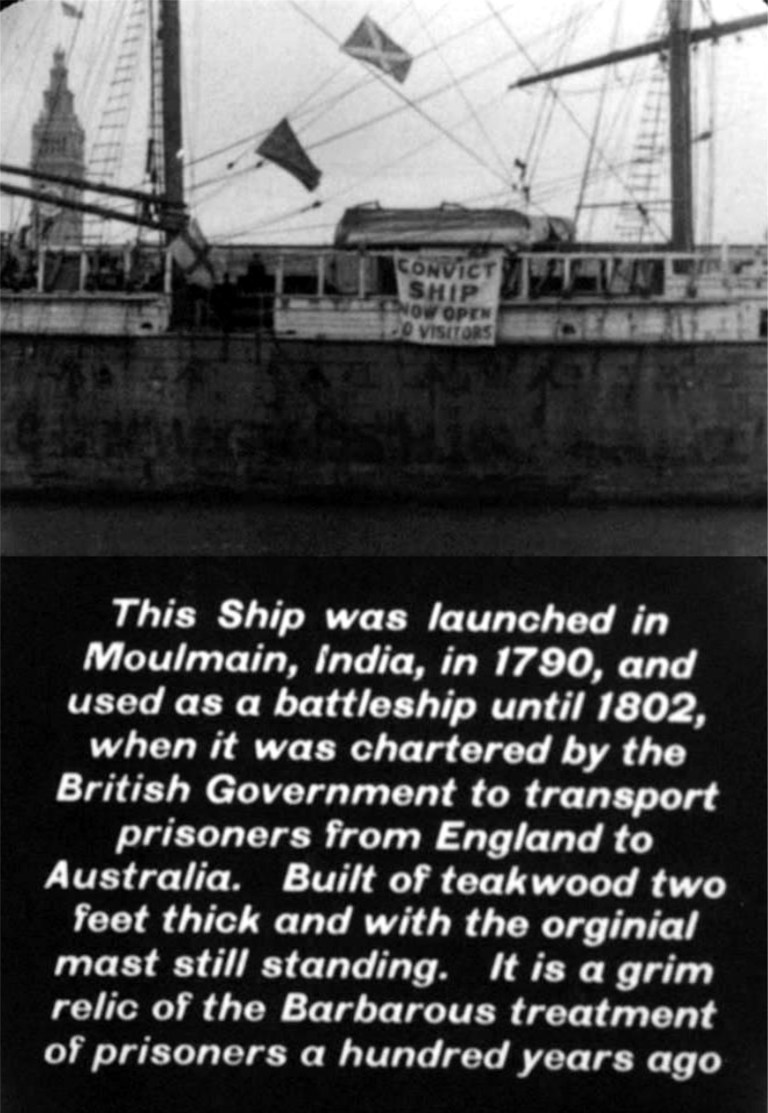 After this scene comes a little comedy. One of the attractions at the time was an English prisoner ship ‘Success’ tied up at the Ferry Building.
  Mabel and Fatty visit the ship and one of its attractions, the “Iron Maiden”. Now, why do you just know that Mabel is going to go inside of it, and that Fatty will almost accidentally impale her on its deadly spikes!
  “It’s okay, go on in. We won’t let the door close!” Mabel just might be as dumb as she looks!
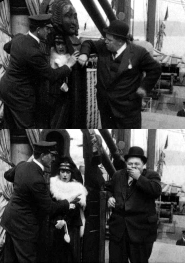
 After nearly being spiked to death, Mabel slaps Fatty’s face. Of course, he does the natural thing and tries to push her back into the Iron Maiden Hey, girls can make you mad!
  The other movie, Mabel and Fatty made in San Francisco in 1915 was ‘Wished on Mabel’ shot entirely in Golden Gate Park.
 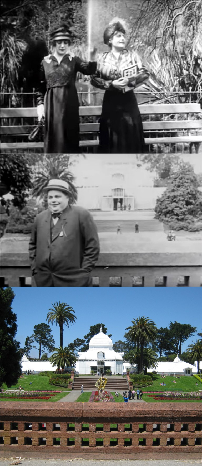 The film opens with Mabel, on the left and her mother sitting on a bench in Golden Gate Park where Fatty, who’s standing in front of the Conservatory of Flowers, notices her. The look on his face tells us right away that he’s smitten by her non obvious charms!
  A number of scenes were filmed at the old Stone Bridge that crosses Stow Lake to Strawberry Hill including these. At the upper left, a lecherous thief starts hitting on Mabel when Fatty comes to her rescue below. Mabel must have something going for her for these guys to be so hot on her! The thief has an encounter with another fellow at the same bench in the upper right photo. There’s still a bench at this peaceful location today, and I wasn’t going to start hitting on the girl there, I don’t want Fatty coming after me!
  A kiss near the end of the film between Mabel and Fatty near the stone path below the waterfall that runs down Strawberry Hill, and all’s well that ends well, but not in real life! Roscoe Arbuckle, whose career was ruined by the St. Francis Hotel rape scandal, died of a heart attack in 1933 at age 46. Mabel Normand had died of tuberculosis three years earlier in 1930, age 37. Even Mayor “Sunny Jim” Rolph died around this time in 1934. The rocks at the stone path here have been replaced during the last hundred years, but the spot looks pretty similar today. Incidentally, if you like the movies, click on the link below for a collection of film clips from movies made in San Francisco that I posted in September of 2015.