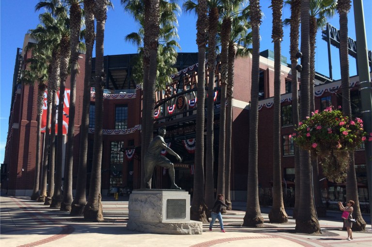
 It’s Orange Rocktober again, and the San Francisco Giants are in the Playoffs, although, as of this posting they’re down one game to nothing. So, I thought I’d put on my old Giants jersey and head to AT&T Park to do then and nows near the park courtesy of opensfhistory.org. No matter what happens tonight, The Giants will be back here on Monday, and this place will ROCK! (Look at the girl posing like the Willie Mays statue for the camera)
 http://opensfhistory.org/Display/wnp14.2626.jpg
You can drive to AT&T Park, take public transportation, or walk along the waterfront to the park, as I did today. Here is the old Seaboard Hotel at Howard and the Embarcadero in 1938. This old hotel, which was demolished at the end of the 1970’s, was featured in at least two films. The Seaboard would have been just behind where the first car is turning on to the Embarcadero from Howard Street.
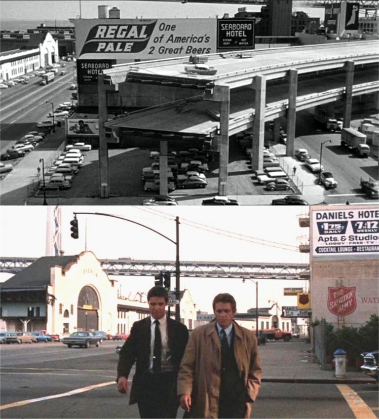 The Embarcadero Freeway, which once ran past the Seaboard Hotel at this location, can be seen in the top picture from the chase scene at the end of the 1958 movie ‘The Lineup’. From Rainier Ale to Regal Pale, I don’t know if that was a step up or down! In the bottom picture, Steve McQueen hides a witness against organized crime here for his protection when it was called the Daniels Hotel in 1968’s ‘Bullitt’. (It didn’t work; the hit men got to the witness, and killed him)
 http://opensfhistory.org/Display/wnp14.2712.jpg
One block further south is the old Hills Brothers Coffee Factory, seen here in 1938. The Embarcadero has been reconfigured since 1938, and doesn’t turn at the same angle here as it once did. The old sign reads $6 TO LOS ANGELES. I just want the Giants to get past the Chicago Cubs, and get to Los Angeles to face the Dodgers next!
 http://opensfhistory.org/Display/wnp26.091.jpg
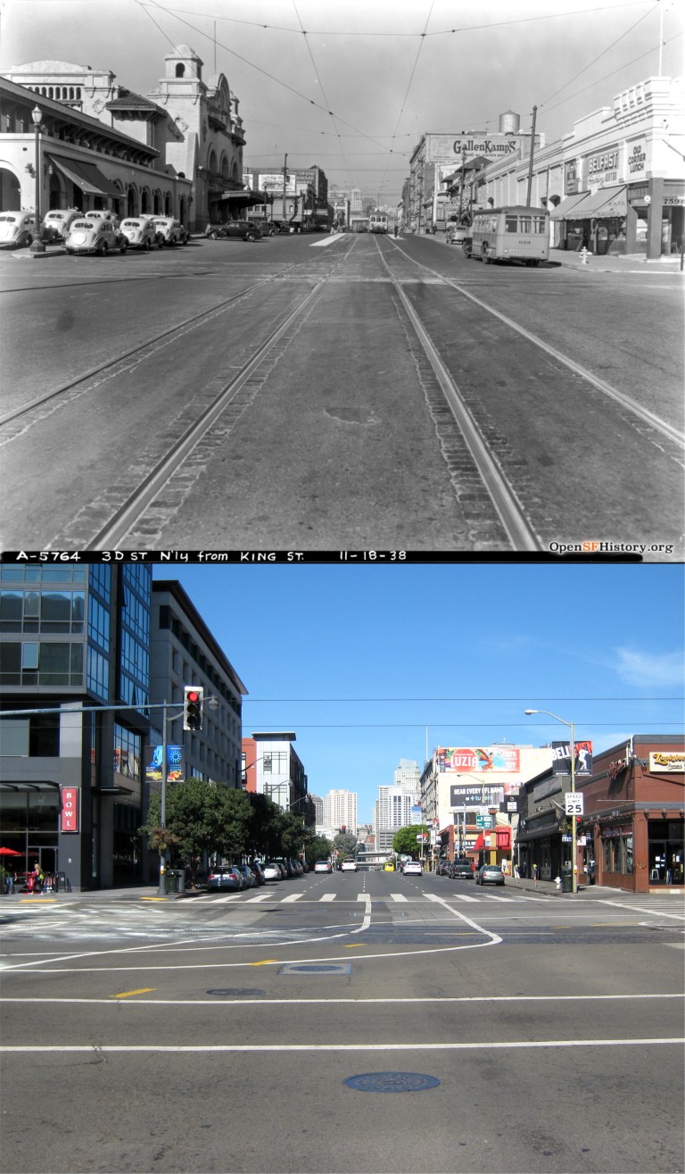
Kitty-corner from AT&T Park at 3rd and King Street was once the old Southern Pacific Railroad Depot, seen on the left in 1938. This train station was demolished near the end of the 1970’s.
 http://opensfhistory.org/Display/wnp32.0096.jpg
Bob Hope and Jerry Colonna arrived at the Southern Pacific Depot in May of 1942 on a tour to raise money for the army and navy during World War Two. I don’t recognize who the girls were. The passenger trains still pull up behind the train depot today on the same tracks as in 1942, but now the station is one block southwest, and is the 4th and King Street Station.
 http://opensfhistory.org/Display/wnp32.0060.jpg
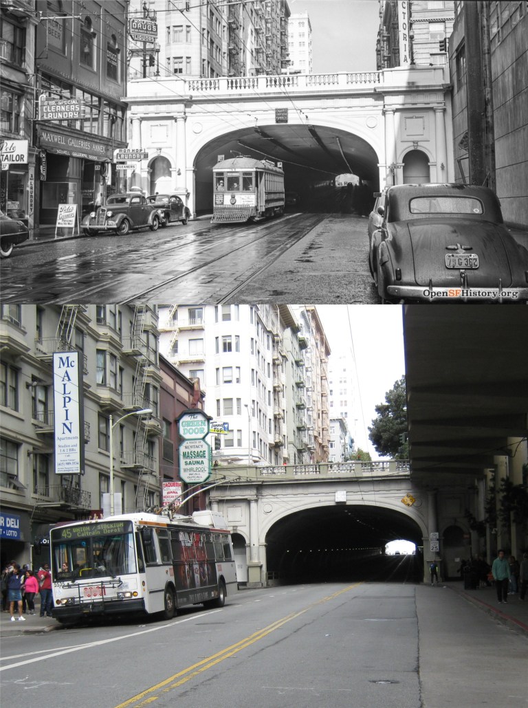
Slide! I’ve got baseball on the mind! A streetcar slides off the track at Stillman and 4th in 1947. That’s the old and new Highway 80 approach to the Bay Bridge in the back. It’s been completely redone since the vintage picture. This accident doesn’t look too serious, but wait until you see the next one.
 http://opensfhistory.org/Display/wnp14.2344.jpg
I’ve got a bad feeling about this one; a train collision with a truck at 7th and Irwin in February of 1945. Given the extent of the damage to the cabin of the big rig in the right center of the vintage photos, it’s unlikely that the driver survived. A Caltrain commuter liner zooms past homeless encampments at the site of the accident today.
 It’s also Fleet Week in San Francisco. Look at that line of visitors waiting to board the USS San Diego! Two of the fellows off one of the ships were kind enough to oblige me with a photo in a pizza parlor across from AT&T Park.

 Hyde and Union Streets on Russian Hill in the mid 1970’s: You can just make out Swensen’s Ice Cream Parlor on the left in the vintage picture. I fall prey to their ice cream every time I’m in the area, even on cold days like this. (Peter Stratmoen)
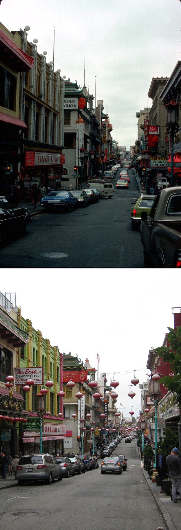 Chinatown in the mid 1970’s: (Peter Stratmoen)
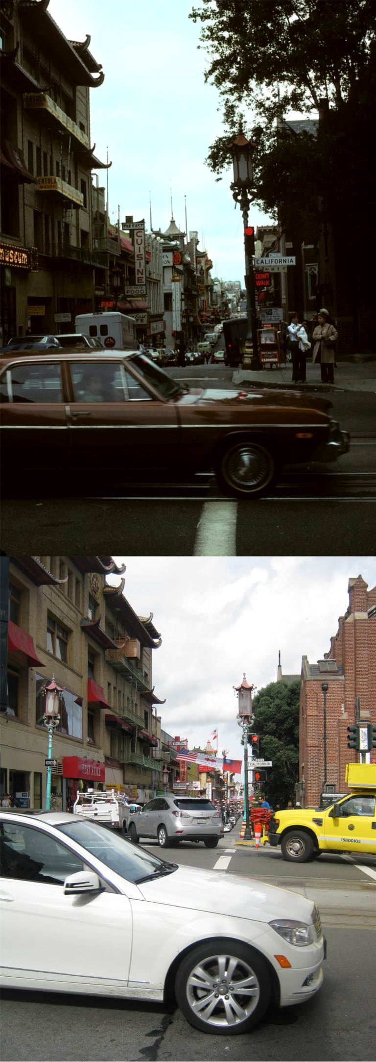 You know, I felt sorry for Mr. Stratmoen having his 1975 photograph at California Street and Grant Avenue spoiled by a passing car, so I thought I’d update it for him. Well, what do you suppose happened?
 The Southwest corner of Alta Plaza in the 1950’s (Phil Palmer)
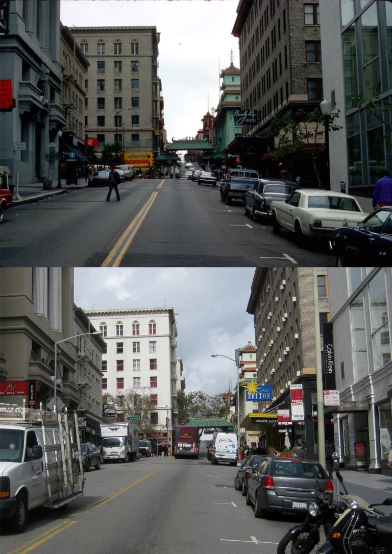 Grant Avenue, just down from Chinatown, in another Peter Stratmoen photo from 1975: The sun finally came out just as I was heading for home. Notice the building on the left with the columns and arched entrance; this was the Pacific Telephone Exchange Building during World War Two. It was considered so vital that sand bags were stacked covering the entire entrance after Pearl Harbor in case of a Japanese air attack, although, I don’t know what good this would have been on a direct hit. (See the next photograph)
 Mission and Steuart Streets in 1983: The Embarcadero Freeway and the Bay Bridge are in the background. That’s the Audiffred Building on the left corner. Originally built in 1889, it’s on the National Registry of Historic Places.
 The Embarcadero Freeway; how I miss it, NOT!!!
 The crosswalk at Powell and Market Streets in 1983: They had just begun running the old time streetcars again on Market Street; this is now the F Line.
 From 1982 to 1984, the entire cable car system was shut down for repairs. When I took this slide photo in the spring of 1983 on the corner Powell and Geary at Union Square, you could see the construction work being done on the line.
 California Street between Grant Avenue and Stockton Street: Two slug bugs! No cable cars meant any cable cars! The California Street line was shut down, as well. You can see them digging up California Street at the bottom of Nob Hill. To this day, I still stop to watch a cable car pass by when I see one. How did we get along two years without them!
 In June of 1984 the cable car lines reopened and San Francisco threw a celebration in honor of the occasion. This was taken a little farther up Powell Street from Geary between Union Square and the St. Francis Hotel.
 Grauman’s Chinese Theater, where the Stars leave their mark in cement:
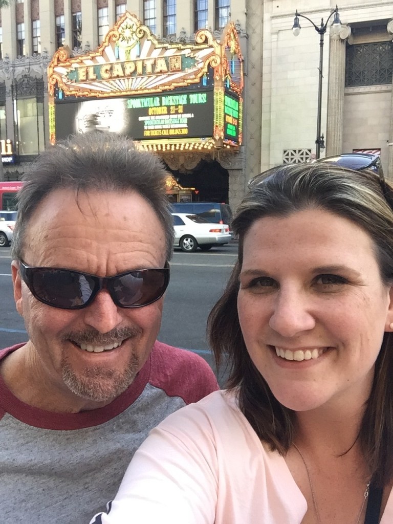 The El Capitan Theater on Hollywood Blvd.: Clark Gable played on the stage there before breaking into the movies. “You can see all the Stars in my sunglasses as you walk down Hollywood Boulevard.”
 Somehow, I just don’t match up. Cary’s square in the picture doesn’t match up to the one that’s there today, either; I guess they redo those later sometimes.
 Tucked away on Vendome Street not far from Downtown Los Angeles are the stairs Laurel and Hardy used in their Academy Award winning short comedy ‘The Music Box’, made in 1932. The plot is simple; Laurel and Hardy are two delivery men attempting to carry a player piano up a long flight of stairs to a customer. After a series of hilarious mishaps, (you know Hardy is going to fall down these stairs at least several times because of bumbling mistakes made by Laurel) and encounters with quarrelsome people, they get the piano to the top of the stairs. There is a plaque dedicated to the film on one of the steps near the bottom of the stairs. (brentononfilm.com)
 Ah, sacred ground. Several miles from the stairs where Laurel and Hardy filmed scenes for ‘The Music Box’ are the stairs where the Three Stooges filmed the icemen scene in ‘An Ache in Every Stake’ from 1941. We’re parked where the Stooges parked their ice wagon in the opening of the scene.
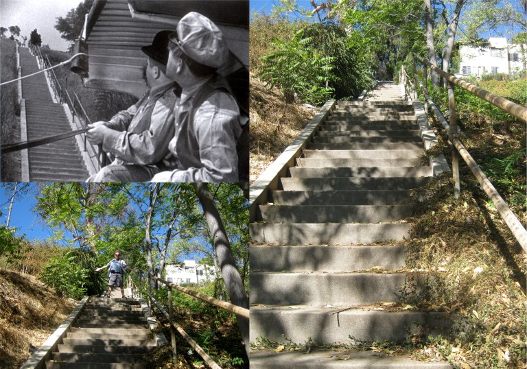
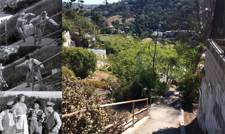 In those days, not everyone could afford a refrigerator and some had an ice box, supplied regularly by deliveries from the iceman. When the Stooges arrive, they see that the lady ordering the ice is at the top of a ridiculously high flight of stairs. No matter how hard they try to get the ice up to her, the ice blocks melt by the time they’re at the top. It doesn’t get any better than this! My picture is looking down from where the lady was waiting at the top of the steps.
 I can’t go down to Los Angeles without going to Disneyland. I’ve been doing that since I was a kid, which, on last Thursday, was just yesterday. Here’s a little Disneyland trivia you may already know. Vice President Richard Nixon and Patricia were there along with Walt for the opening of the Monorail in 1959. (They were there for the opening of BART too; there’s seems to be a pattern here!) The nose of the trains stop beyond the exit gate, so I couldn’t get an exact then & now unless I walked out on the track, and they probably would have said something to me. I’m glad that was running this time because it’s one of my favorite Disneyland attractions and far less scarier than It’s a Small World!
 One of us got older!

 A lower tide and less people for me today than for Fred Lyon in his 1950’s picture of Ocean Beach from Sutro Heights:


 Chinatown, with Old St. Mary’s on the right, in 1943. (Life Magazine)
 Boy, those sailor fellows sure do alright! Wow, her coat matches her hair! They’re sitting at the exact spot in 1943 where the San Francisco Main Library is today. Behind them is the Pioneer Monument which was moved farther north in 1993 when the new library was built. Behind the monument in the old photo is the intersection of Hyde and Grove. The building behind the Pioneer Monument in the 1943 picture is, actually, the Orpheum Theater. (Life Magazine)
 The crew at the bridge of the World War ll submarine USS Pampanito, and the bridge today. The Pampanito saw a lot of action in the Pacific Ocean during the war.
 A Gold Star Ceremony at Chestnut and Baker Streets awarded to Kenneth Campbell of the U.S. Navy who was killed in 1943. They did this a lot during the war. The arrow shows where the Gold Star was placed. The pole is still there, but the Gold Star is long gone and replaced by a No Left Turn sign. (Images of America)
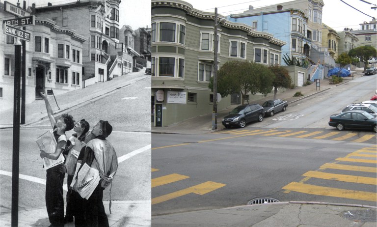 Kids point to a Gold Star Marker placed at 18th and Sanchez in January, 1943 for marine Donald Gray, killed in action at Guadalcanal. (Images of America)
 “When Johnny comes marching home again, Hurrah! Hurrah!” Victorious army soldiers on Grove Street in a victory march at the end of World War ll. The Owl Drug Store on the right was on the corner of Hyde and Grove Streets in the Orpheum Theater Building in the vintage picture. My photo is closer to Larkin Street because the San Francisco Main Library blocks the view of City Hall from Hyde at Grove today, (Images of America)
 Pier 15 being deactivated when the war ended: “Alright babes, glad that’s over. Let’s go get a beer!” (Images of America)
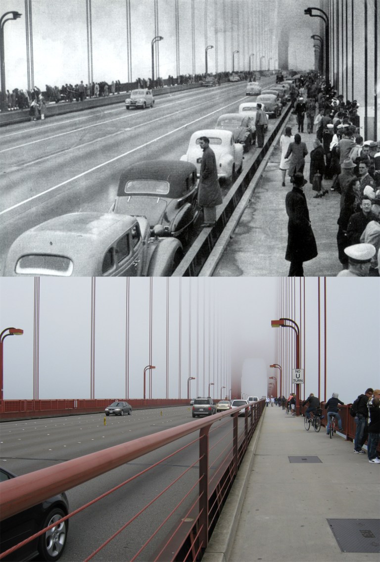 Civvies line the Golden Gate Bridge to watch the arrival of Navy troop ships and war vessels coming home again at the end of World War ll. “Welcome home. Well done!”
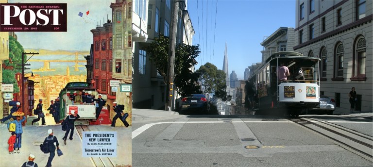 This wonderful cover for the Saturday Evening Post ran twenty seven days after the official end of World War Two, and paints an image of a happy optimism among the returning sailors. The cable car is getting set to dip down Washington Street at Jones into Chinatown. Cable cars still take the plunge here seventy years later. I first learned of the Post Magazine cover when reading Gary Kamiya’s fine book about San Francisco ‘Cool Gray City of Love’.
 This photo is of a little known and interesting incident. There had been many rumors during World War ll that a Japanese submarine had fired a torpedo at the Golden Gate Bridge in the early days after Pearl Harbor. In June of 1946, that rumor turned out to be true when an unexploded Japanese torpedo was found at Marshall’s Beach just west of the bridge. What damage it could have done if it struck the bridge or which submarine fired the torpedo has never been determined. This is not an easy spot to get down to; you can only reach this area at low tide. Sandstone steps lead down the cliff to the beach, and it’s a long and tiring climb back up! Trust me on this one! Because of its secluded and often inaccessible location, it’s also used as a nude beach. Do yourself a favor and trust me on this one too. I tried for as long as time would allow to find the exact rock in the old photo, but 70 years have passed, and much of the time many of the rocks are underwater, so it may not even look the same anymore.’. (Images of America) For more on San Francisco during World War Two, click on the link below for a series of pictures I posted in March of 2015 called ‘World War Two and the San Francisco Giants’.
 To me, the most historic Bay Area film location is in sleepy little Niles, California. This is where the world came to know of Charlie Chaplin’s “little tramp”. The top image is of the Essanay Studio where probably the greatest clown in cinema history was created. The old picture was taken shortly before the studio closed. Chaplin filmed a scene of a confrontation with a policeman in his film ‘The Champion’ on the corner where the two children are standing. Today a fire station is located here.
 The Hotel Wesley, where Charlie Chaplin stayed while he was filming in Niles, when he wasn’t crashing at Edna Purviance’s house down the street: This building has changed very little in over a hundred years!
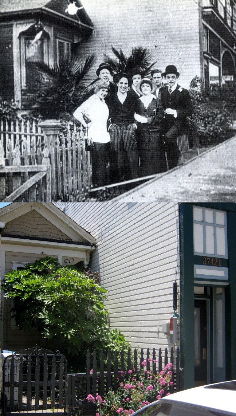 Edna Purviance, on the far left next to Chaplin, was his leading lady in most of the movies he filmed in Niles, and she stayed in the house behind them while she was in town. And yes, they were horsing around, but Chaplin got bored of the Niles night life, and left for Southern California. Well, after all, it was only a one-horse town! Edna’s little house has survived, as has the building next to it where Chaplin originally premiered his movies shot in Niles.
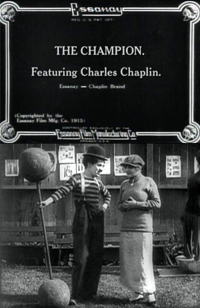 The best movie Chaplin made in Niles was his 1915 short ‘The Champion’ with Edna Purviance. This movie was shot entirely in downtown Niles, mainly on the corner of G Street and Niles Blvd. where the Essanay Studio stood.
 Chaplin wanders down G Street past the fence of the Essanay Movie Studio back lot followed by a puppy he shared his lunch with earlier in his 1915 movie ‘The Champion’, and where Charlie and his little buddy were walking today.
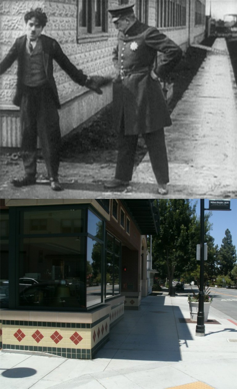 Chaplin confronted by a police officer in ‘The Champion’ (Look at that uniform!) and the same corner today.
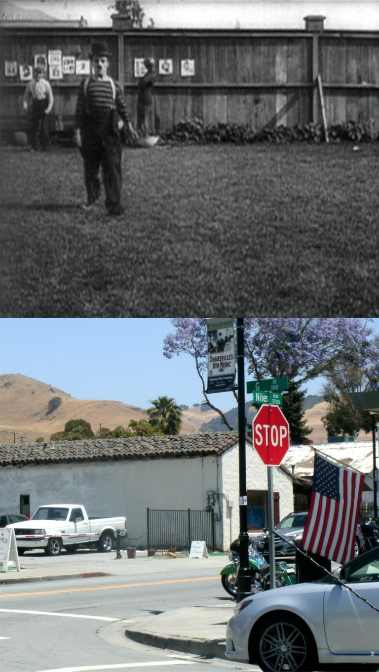 Chaplin, preparing for the big fight, works out in a scene filmed in the back lot of the studio. Notice the mountain above the fence in the upper left of the Chaplin scene. You can still see it from Niles Blvd. and G Street today. I learned about the mountain comparison from reading John Bengston’s fine book ‘Silent Traces’.
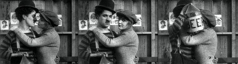 After winning the big fight, Charlie puts the moves on Edna, but when they become aware of the film audience, he kisses her behind his beer jug. (That’s a nice size beer!) Incorporating the audience into the film was a relatively new gag back then.
 Cable cars pause at the intersection of Grant and California to catch their breath before chugging the rest of the way up Nob Hill. They don’t do that really, but I’d like to be a writer someday, so I thought I’d try that line out.

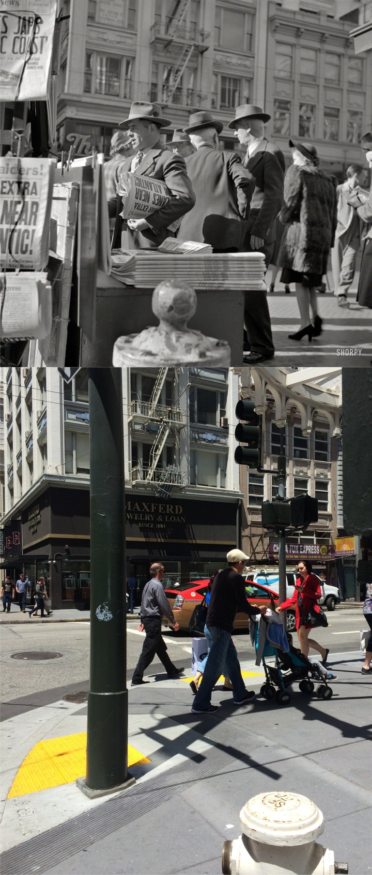 Finding these locations is always fun for me, but it can also be challenging, especially if the location is misidentified. Above are three great pictures taken in San Francisco on December 8th 1941, the day after Pearl Harbor. Although their site is a knockout, Shorpy identifies these historic photos as being taken at Montgomery and Market Streets, and that’s not the location. Nothing matched up, nor did any of the old pictures of that intersection that I could find. The key to finding this spot was in the tall building in the distance at the center of the first comparison picture. That looked to me like the old Sir Francis Drake Hotel. If it was, then I had to find out what angle the pictures were taken from. You can’t see the Sir Francis Drake from here anymore, but these pictures were shot on the northeast corner of Sutter and Kearny looking west. I had a weird feeling standing on this corner when I took these, thinking about the people here almost 75 years ago, and what was going on in their minds.
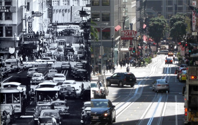 There’s three crossroads in this shot looking down Powell Street toward Market; Geary, O’Farrell, and Ellis Streets. No, that’s not a Stud Hotel sign on the left in the vintage picture; I did a double take too. It’s an Art Studio sign behind the Hotel Stratford sign.
 “Patience is a virtue”, only it’s one of the many virtues that I don’t have. Still, when it comes to getting two cable cars in the picture at the only spot where the California Street and Powell Street cable car lines cross as in the vintage photo, I had to be patient. Cable cars don’t always get here at the same time. I got a reasonable facsimile. That little pagoda on the right isn’t a convenient place to go to the bathroom, (I wish!) it’s a control box that regulates which cable car has a green light to go into the intersection before stopping to pick up or unload passengers when they get there together. The old Crest Garage that goes back to the 1920’s is still there behind the cable cars, only now it’s a parking garage.
 Tomorrow is the start of Fleet Week, 2016 in San Francisco. That’s the U.S.S. West Virginia coming into the Bay before the United States entered World War ll, and the U.S.S. Iowa going out in 2012. The West Virginia was sunk at Pearl Harbor; the Iowa will, probably, be the last battleship to sail under the Golden Gate Bridge.