For Mom

My mom would have been one hundred years old today. She got to San Francisco long before I did. (Thumbnail images)

My mom, on the left with her cousin Frances, at the house at Anza and 24th Avenue, when she came out by train when from Grand forks, North Dakota:

Fisherman’s Wharf, where Joe DiMaggio’s Restaurant on Jefferson Street used to be:

Mom, on the right, at the old De Young Museum in Golden Gate Park:

At the old Sloat Blvd. entrance to the San Francisco Zoo, then known as Fleishhacker Zoo:

The Cliff House and Ocean Beach:


Alameda County Fair, 2022


Ah, the first day of summer, and a pleasant reminder that life’s not always where “little cable cars climb halfway to the stars.” About 39 miles southeast of San Francisco, the Alameda County Fair, interrupted since 2019 because of Covid-19, except for a week in October of 2021, began its 110th run. This IS what county fairs are all about. I got a chance to go out there last weekend to update some of those old pictures taken at the fairgrounds from the Images of America’s revised edition of its Alameda County Fair volume.(Thumbnail images)


Most visitors still enter the fair at the same location that they did here in the 1960s.


Audrey Hepburn wannabes at the Midway in the 1950s:


The Model Train Exhibit has come a long way since this 1948 picture was taken.

They still have plenty of the picture booths where visitors take those silly pictures of themselves. Yeah, that’s me; I was just as silly once too.


Dressed up visitors entering the old Floriculture Building, looks like the 1960s:

Tipsters at the old horse racing grandstand in the early 1960s: This grandstand was replaced in 1965.

A beauty contest on the Court of Four Seasons stage during the 1960s: This was about the only entertainment stage in the fair up until the 1970s. This is where the Court of Four Seasons stage once was.


The Chinatown Dragon Gate

Originally, the general consensus was that the southern border of Chinatown was Pine Street. By the 1920s, Bush Street had become more accurate. Even Dashiell Hammett points that out in his classic mystery novel ‘The Maltese Falcon’ when Sam spade takes a cab to the spot where his detective partner Miles Archer was murdered. {Where Bush Street roofed Stockton before slipping downhill to Chinatown, Spade paid his fare and left the taxicab. San Francisco’s night-fog, thin, clammy, and penetrant, blurred the street}. In 1968, construction began on the Chinatown Dragon Gate at Grant Avenue and Bush, a gift from Taiwan, permanently establishing Bush Street as the southern gateway to Chinatown. The gate was completed in 1970, and is probably the most photographed spot in Chinatown. Yesterday’s post Pandemic visitors were back here with their cameras, including me. (Thumbnail images)

This is where {Bush Street (roofs the Stockton Tunnel) before slipping downhill to Chinatown} and Grant Avenue where the Dragon Gate is. (San Francisco Pictures Blog)

These two pre Dragon Gate pictures show the view from Bush Street looking up Grant Avenue to Pine Street. They show a lively, although not completely Chinese in theme, stretch of block. The first picture is the cover of a recent book, definitely on my bucket list, and the second one is from the San Francisco Pictures Blog.

Before the Dragon Gate, there was another gateway erected here at Bush Street, as seen in this picture from the 1930s, but I haven’t found a lot of information about it yet.

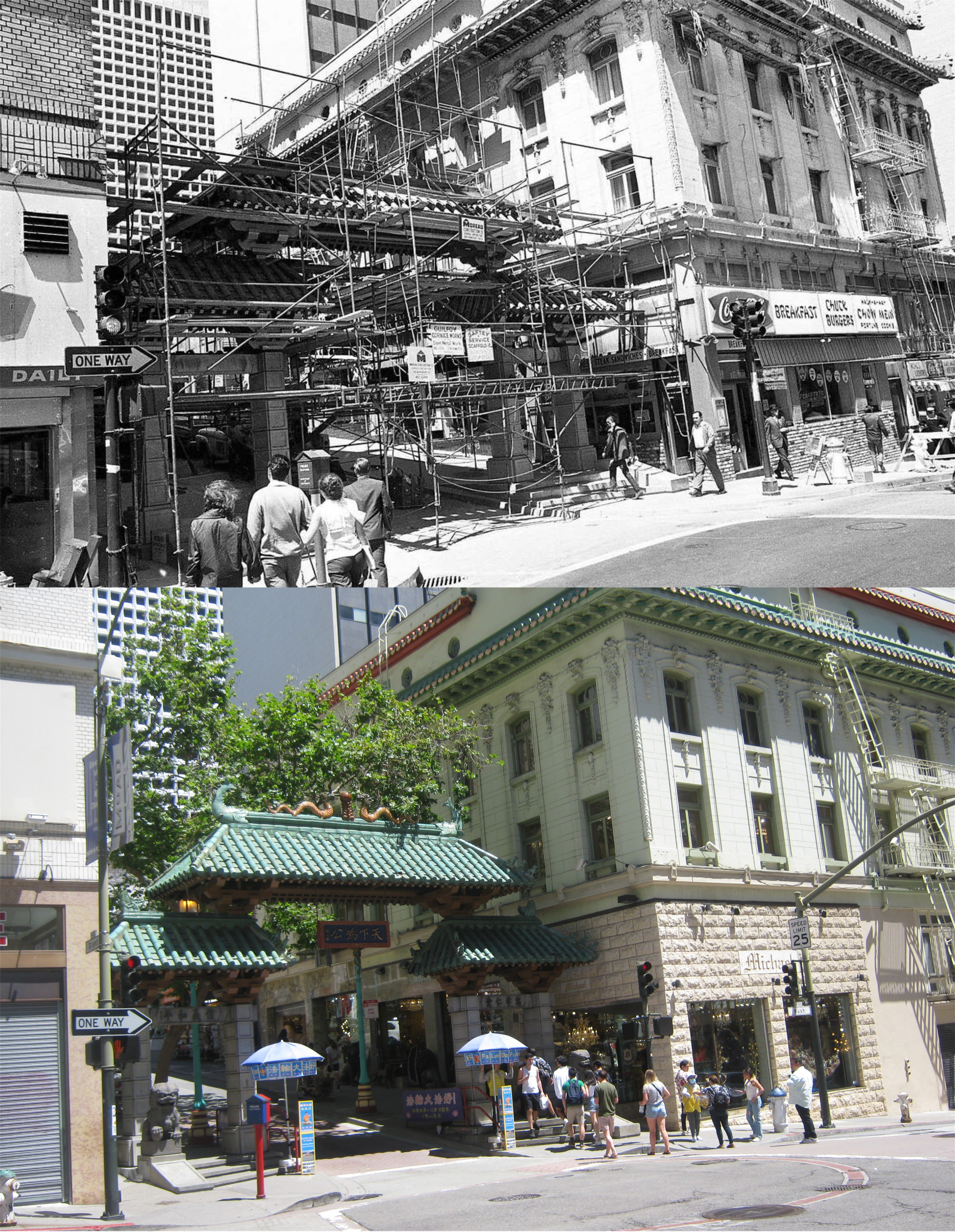
The rest of the vintage pictures were taken by photographer, Vince Maggiora, for the San Francisco Chronicle newspaper during construction of the Dragon Gate from 1968 to after its completion in 1970. Here you’re looking northeast from Bush Street and Grant Avenue in 1969:

The view from the southeast corner of Grant Avenue and Bush Street: I’ll bet there was a lot of burger and soda breaks among the crew.

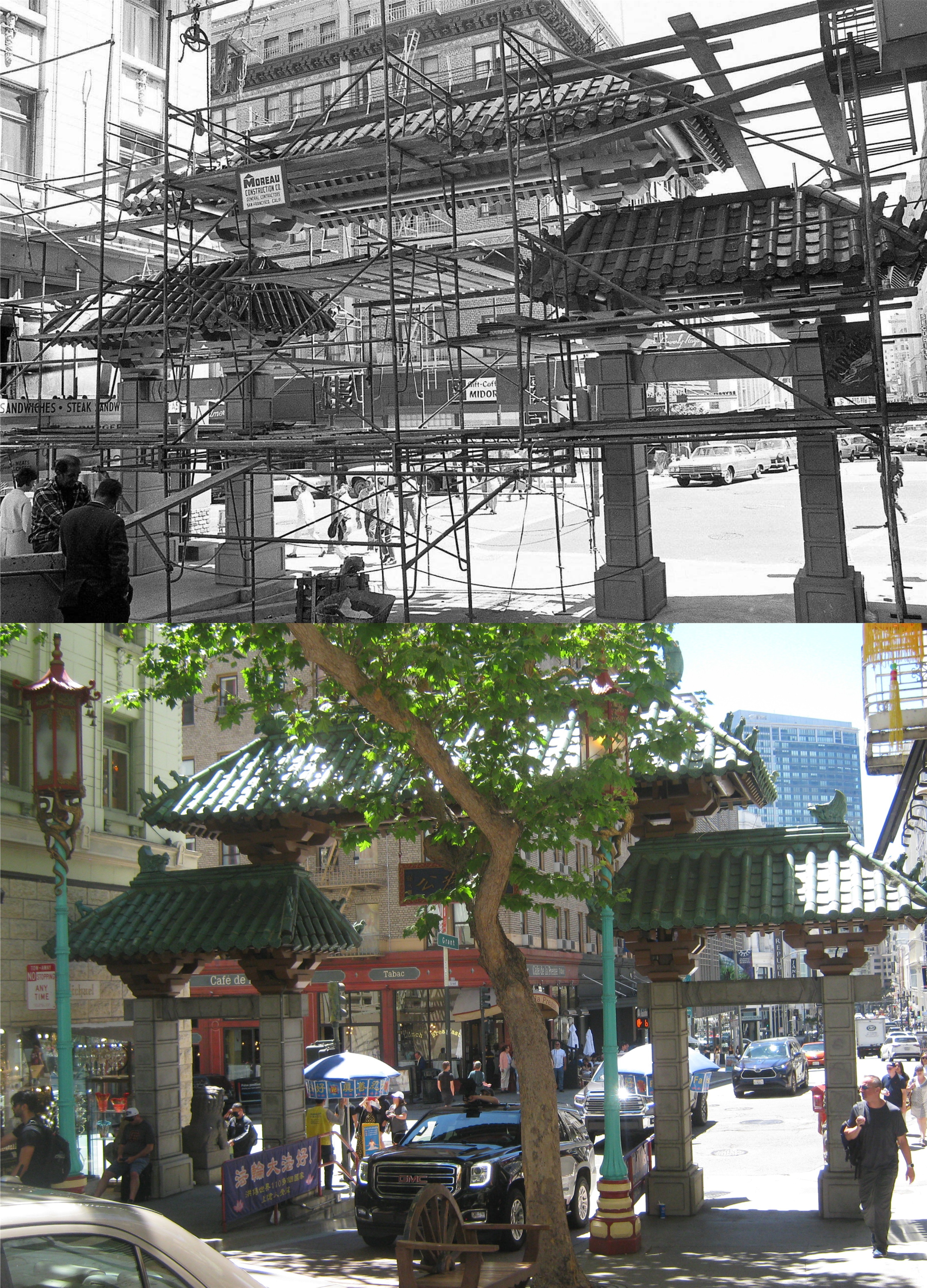
Looking back through the gate to the southeast corner of Grant Avenue and Bush Street during construction:

Looking south down Grant Avenue toward Bush Street in 1971, after the gate’s completion:

Driving and walking through the Chinatown Dragon Gate, seen here in Vince Maggiora’s 1972 picture, has become another San Francisco must-do.


Muni Heritage Day, 2022

Muni Heritage Day, 2022: Great fun for everybody and a chance for me to update some slide pictures I took in the 1980s. (Thumbnail images)

The festival was held here between Steuart Street and the Embarcadero, in front of the Muni Heritage Museum. The Muni Heritage Museum building wasn’t around when I took my 1984 slide with the infamous Embarcadero Freeway in the background.

The free streetcar rides took the less traveled route down Steuart, and left on Mission to the Embarcadero. My picture of the intersection is from 1984; you can see the Bay Bridge and the Embarcadero Freeway in the far background.

I headed over to Market Street to hitch a bus ride up to the Civic Center. The older image is from 1983; the Embarcadero Freeway would have been behind me.


8th and Market Street, looking toward the Orpheum Theater in 1985: This would have been around the time the F Line started running vintage streetcars on a regular basis.

Market Street at Powell, looking toward the Ferry Building in 1985: The streetcar in the vintage picture was in Saturday’s festival and maybe the bus next to it too. There are a lot of vintage buildings in these shots too; the Flood Building on the left, the Phelan Building, the Call Building, the Humboldt Building and the Emporium Building across Market Street, among others.

I even got a chance to update my picture from Muni Heritage Day, 2016. I haven’t changed a bit in six years; I mean, except I got older, and more tired, and have less energy, but other than that…..


7th, 8th, and 9th Streets

This is a follow up to my 4th, 5th, and 6th Streets post, which was a follow up to my 1st, 2nd, and 3rd Streets post. It doesn’t getting any lower than that, (in street numbers). Most of these updates are where the streets intersect with Market Street; you don’t want to wander too far down 7th, 8th, or 9th Streets from Market Street, unless you enjoy seeing “the (bitter) angels of our nature”. (Thumbnail images)

7th Street at Mission Street, looking west along Mission in 1915: In a SOMA area heavily developed now, at least two buildings on the left have survived. (SFMTA Archives/San Francisco Picture Blog)

The old 7th Street Post Office Building, between Market and Mission Streets, circa 1905: They wouldn’t have had too many new-fangled automobiles on the old stone 7th Street back then. (opensfhistory.org)

Looking east along Market Street at 8th in 1941, where the much loved Crystal Palace Market was. Horse Doovers were a MacFarlane Candy confection, with a play on words for the French appetizer expression hors d’oeuvre. (San Francisco Picture Blog)

8th Street, looking toward the old City Hall near Market Street in 1905: The City Hall Building, located where the San Francisco Main Library is today, crumbled within minutes after the 1906 Earthquake. (opensfhistory.org)

Very little has changed looking east along Market Street since 1931; except for the Transamerica Pyramid and the Bank of America Buildings peeking out over the top on the picture right of the old Empire Hotel Building. (SFMTA Archives/San Francisco Picture Blog)

Looking west along Market Street at 9th in 1985; they were just beginning to run the old streetcars along Market Street back then. Twin Peaks are in the far background of both pictures. (San Francisco Picture Blog)

Only motorcycle parking is allowed now in front of the old Wells Manufacturing Company Building on 9th Street, south of Howard Street. The vintage picture is from 1951. (opensfhistory.org)