 In 2011, the University of California Press reprinted a 1940 guide to San Francisco written by the Federal Writers Project (WPA) of the Works Project Administration (WPA). The Works Progress Administration was the result of Executive Order 7034, Signed by Franklin D. Roosevelt in 1935 to create jobs for unemployed workers, artists, musicians, etc. during the Great Depression of the 1930s. A lot of the San Francisco we appreciate today, such as the murals inside Coit Tower and the Beach Chalet, and the exhibits at the San Francisco Zoo came about because of WPA. The ‘San Francisco in the 1930s’ WPA Guide has numerical descriptions that correspond with maps in the book. The points of interest listed take in just about all of San Francisco with occasional outdated descriptions that were new in 1940. These are a collection of some of the descriptions of places from the book, (in brackets) with vintage pictures I updated of each location taken close to the period when the book was written.
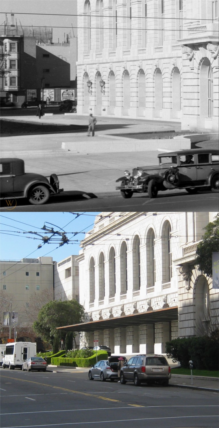 The south side of the Opera House on Van Ness with long gone buildings on Franklin Street in the background: (Vintage picture from worthpoint.com)
{The OPERA HOUSE (open weekdays 10 -4) NW corner Van Ness Ave. and Grove St., and the Veterans Building form the War Memorial of San Francisco, erected in 1932 as a tribute to the city’s war dead.}
{This, the Nations only municipally-owned opera house, represented the achievement of years of struggle by San Francisco music lovers for an opera house of their own. It was opened October 15, 1932 with Lily Pons singing Tosca. The auditorium, seating 3,285 persons, is richly decorated. The floor of the orchestra pit can be raised and lowered. The stage is 131 feet wide, 83 feet deep, and 120 feet from floor to roof.}
The dimensions of the stage area may have changed since 1940.
 The cable car turnaround at Powell and Market Streets:
{Traffic waits good naturedly at the CABLE CAR TURN-TABLE, Market, Powell, and Eddy Sts., where a careening southbound car comes to a halt every few minutes, while conductor and grip man dismount and push the car around until it faces north.}
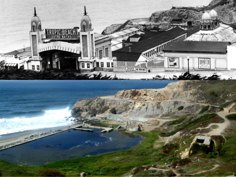 The old Sutro Bathhouse:
{The sprawling building of the SUTRO BATHS AND ICE RINK (open Mon.-Fri. 10 a.m. – 11 p.m.; Sat. , Sun., holidays 9 a. m. – 11 p. m.; skating 35 cents Sun. afternoon and every evening, 25 cents other times; skate rental 15 cents, swimming 50 cents) . Point Lobos Ave. near Great Highway, covering three acres of sloping beach in the lee of Point Lobos, were built in 1896 by Adolph Sutro. Long advertised as the world’s largest are the six indoor pools; of both fresh and salt water, these vary in size depth, and temperature. Also here, are a floodlighted ice rink and an indoor sand plot for sunbathing. It is said that 25,000 persons have visited “Sutro’s” in one day.}
Sutro Bathhouse burned down in 1966.
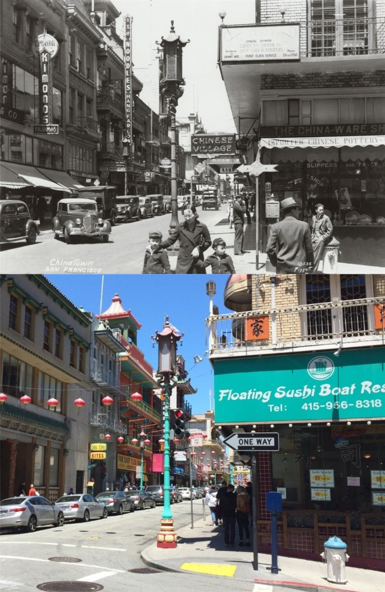 Grant Avenue looking north from Commercial Street:
{A quarter of old Canton, transplanted and transformed, neither quite oriental or wholly occidental, San Francisco’s Chinatown yields to the ways of the West while continuing to venerate a native civilization as ancient the Pyramids. Grant Avenue, its main thoroughfare, leads northward from Bush Street through a veritable city-within-a-city – alien in appearance to all the rest of San Francisco – hemmed within boundaries kept by tacit agreement with municipal authorities for almost a century.}
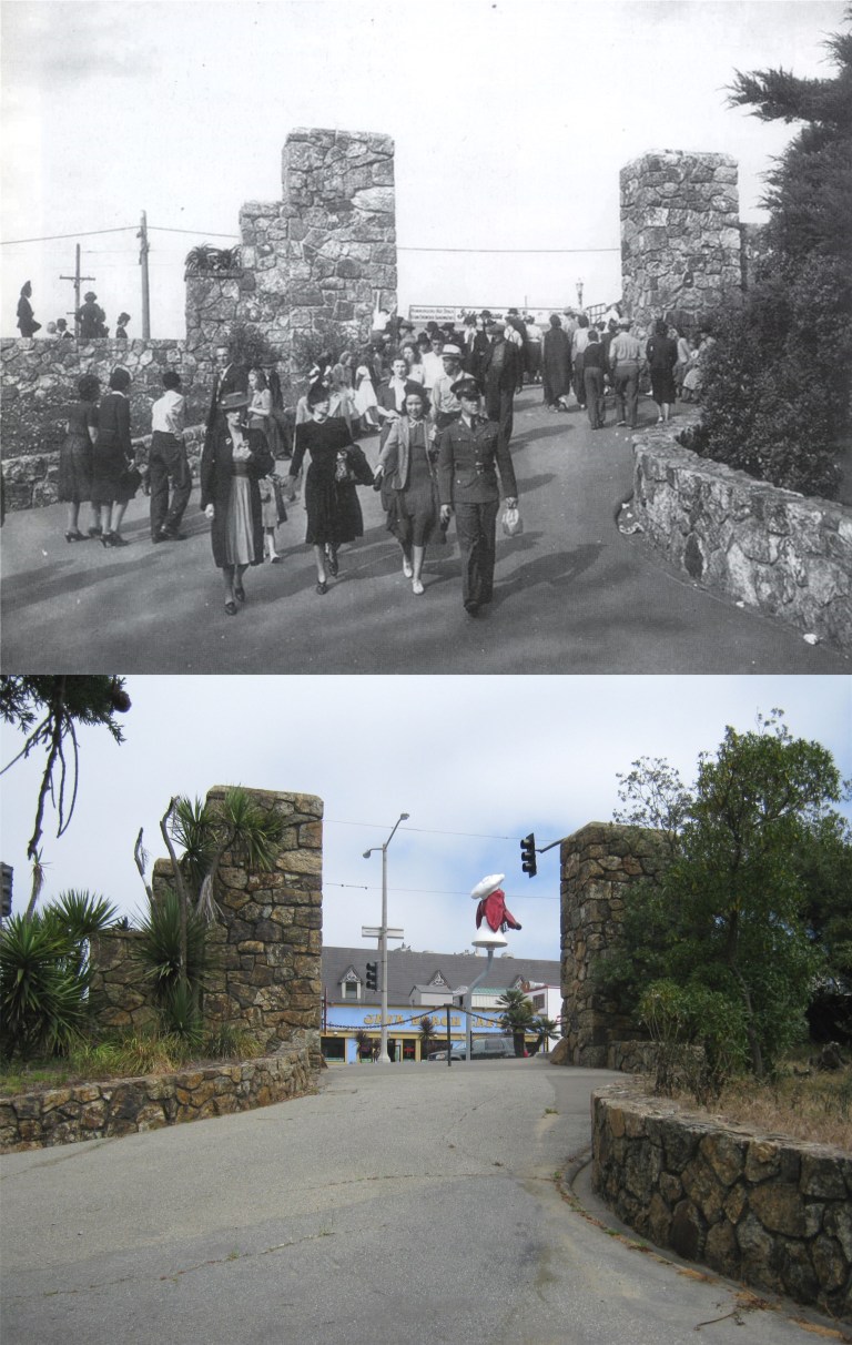 The old WPA built entrance to Fleishhacker Zoo on Sloat Ave.
{FLEISHHACKER PLAYFIELD AND ZOOLOGICAL GARDENS, foot of Great Highway at Sloat and Skyline Blvds. This recreation center dates from 1922, when the city acquired from the Spring Valley Water Company 60 acres on which to construct a playground and pool. Only 37 acres at first were developed; opened in 1924, the park was named for Herbert Fleishhacker , then president of the Park Commission, who donated the pool and the Mothers’ House. Adjoining the playground is the Zoo (open 10 – 4:30; free). Begun in 1929 with a few lion cubs and monkeys, gradually more animals were acquired (by purchase and donation) until the animal, bird and reptile population reached 1,000. Noted is the fine collection of “cats” which includes lions, tigers, leopards, lynxes, and panthers. In 1935 sixty-eight acres adjoining the zoo were purchased and here WPA labor constructed the fine ZOOLOGICAL GARDENS, modeled after Germany’s famous Hagenbeck Zoo. Here, among man-made streams, waterfalls, islands, cliffs and caves, are simulated natural habitats of many animals – separated (where practical) from spectators only by moats and designed to give the animals the illusion of freedom}
The vintage picture is the opening day of the WPA built entrance to the zoo in 1937. I was able to get some pictures there before they boarded it up. (Vintage picture from Images of America)
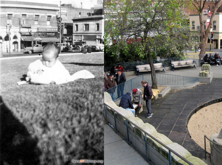
 One of the pictures I was able to get at the old stone entrance to the zoo on Sloat Blvd before they closed it off was the spot where my 17 year old mother on the left with her cousin Frances sat during a visit to San Francisco from North Dakota in 1939.
 The southeast corner of Portsmouth Square:
{Upon the green, sloping lawns of PORTSMOUTH PLAZA, Kearny, Clay and Washington Streets, Candelario Miramontes, who resided at the Presidio, raised potatoes in the early 1830’s. When the plot became a plaza is not known.}
{Most of the stirring events from the 1840’s to the 1860’s took place here – processions, flag raisings, lynchings, May Day fetes.}
{Here terrified Chinese ran about beating gongs to scare of the fire demons during the earthquake and conflagration of 1906; here came exhausted firefighter to rest among milling refugees; here shallow graves held the dead; and thousands camped during reconstruction. The Board of Supervisors, in December of 1927, restored the square’s Spanish designation of “plaza”.}
Well, maybe so, but I read real San Franciscans prefer Portsmouth Square to Portsmouth Plaza, so that’s what I refer to it as. The buildings behind the vintage picture of the square taken in 1937 are still there today. (opensfhistory.org)
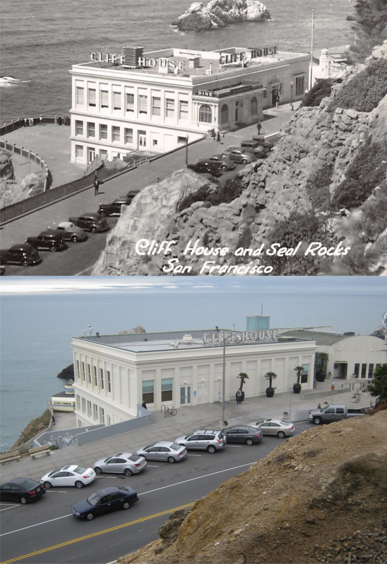 {The CLIFF HOUSE. Point Lobos Ave. at Great Highway, a white stuccoed building terraced along the edge of the cliff south of Sutro Baths, is a modern restaurant, bar, and gift shop. Both the barroom and the Sequoia Room – a cocktail lounge – are finished in redwood, from the smooth walls to rustic beamed ceilings, and both house huge fireplaces in which open fires glow on chilled days. From the lounge and the blue and white dining room in the rear of the building guests seated at the great plate glass windows on clear days look beyond Seal Rocks for miles across the Pacific.}
It’s a crowd pleaser still and you can’t stop progress, but I remember the Sequoia Room with its fireplace well, and I miss the Cliff House the way it was before the New Millennium restoration. (Vintage picture, hippostcard.com)
 The De Young Museum and the Pool of Enchantment:
{On the NW. side of the Music Concourse, flanked by trim lawns and stately Irish yews, is the M. H. DE YOUNG MEMORIAL MUSEUM (open daily 10 – 5). Of Sixteenth- Century Spanish Renaissance design, the buildings pale salmon-colored facades are burdened with rococo ornamentation. Its two wings extend from either side of the 134 foot tower facing a landscaped court. In the court, before the main entrance, lies the POOL OF ENCHANTMENT, in which a sculptured Indian boy pipes to two listening mountain lions on a rocky island.}
Before the De Young Museum was demolished and rebuilt in the New Millennium, I had a chance to take a comparison picture at the spot in front of the museum next to the Pool of Enchantment where my mother, on the right with her cousin Frances posed during her 1939 trip to San Francisco by train while she was in high school. The Pool of Enchantment is now on the eastern side of the De Young Museum.
 The Fisherman’s Wharf Lagoon:
{Twentieth-Century commercialism and Old World tradition go hand in hand at FISHERMAN’S WHARF, foot of Taylor St., where are moored in serried ranks the tiny, bright-painted gasoline boats of the crab fishermen and the tall-masted 70 foot Diesel-engined trawlers of the sardine fleet.}
{The boats of the crab fishing fleet, like their larger sisters of the sardine fleet, are brightly painted, with blue and white predominating hues. During the fishing season (November through August) the crab fleet usually leaves the wharf with the tide – between two or three o’clock in the morning – bound for fishing grounds between three and six miles outside the gate, where each boat anchors within hailing distance of its neighbor. In mid-afternoon they return laden from one to four dozen crabs apiece, accompanied by screaming hordes of gulls.}
Most of the boats in the lagoon in the 1940 picture from the Charles Cushman Collection do appear to be blue and white, and even a number of them today.
 The Embarcadero near Green Street, looking south:
{Even before the eight o’clock wail of the Ferry Building siren, the Embarcadero comes violently to life. From side streets great trucks roll through the yawning doors of the piers. The longshoremen, clustered in groups before the pier gates, swarm up ladders and across gangplanks.}
{Careening taxis, rumbling under slung vans and drays, and scurrying pedestrians suddenly transform the waterfront into a traffic thronged artery.}
{Stored in the Embarcadero’s huge warehouses are sacks of green coffee from Brazil; ripening bananas from Central America; copra and spices from the South Seas; tea, sugar, and chocolate; cotton and kapok; paint and oil; and all the thousand varieties of products offered by a world market.}
Maybe a long time ago, but not anymore. You can’t see the Ferry Building from this spot anymore through the palm trees either, but you can still see the pointed YMCA Building in the far background.
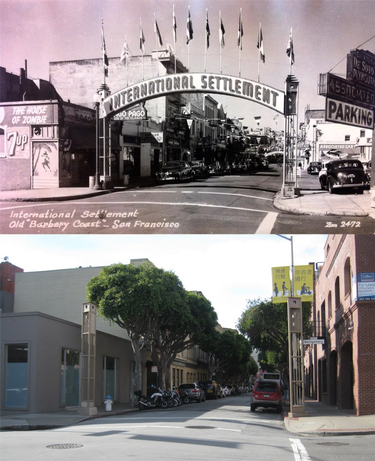 Pacific Avenue and Montgomery Street looking west and the old signposts of the eastern side of the International Settlement:
{The “Terrific Street” of the 1890’s – that block of Pacific Street, SITE OF THE BARBARY COAST, running east from the once-famous “Seven Points” where Pacific, Columbus Avenue, and Kearny Street intersect – is set off now at each end by concrete arches labeled “INTERNATIONAL SETTLEMENT”.}
{Where gambling halls, saloons, beer dens, dance halls, and brothels once crowded side by side, a Chinese restaurant, a night club and cocktail bar, a Latin American café, and an antique shop now appear,}
World War Two would change all that after this passage was written when soldiers and sailors on leave brought back the “gambling halls, saloons, beer dens, dance halls, and brothels”. It’s interesting how they referred to it as Pacific Street in the book rather than Pacific Avenue. The House of Zombie and Pago, Pago Buildings on the left are still there. (Vintage picture, Flickr)


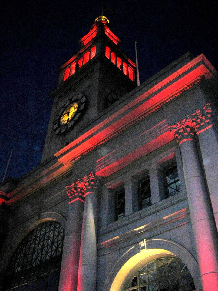
 The old Southern Pacific Building on Market Street is getting into the fun, but the Ferry Building, all aglow in red in 2013, didn’t change its color this time.
 The sidewalk lights on the Embarcadero, (Herb Caen Way) were changed to red back in 2013 and you could stand in the glow. No red sidewalk lights at Pier 1 this time. “I wore a younger man’s clothes” back then. Oh, wait; those are the same clothes I was wearing last Sunday!
 The Billy Graham Civic Auditorium is in gold and red this year.
 I got a fuzzy picture of City Hall on that January Saturday night in 2013 and another last night. It’s not that I’m a better photographer since seven years ago; I just have a better camera now.
 A MUNI bus coming along Post Street in January, 2013: We won’t see that this year.
 Mason and Sacramento Streets looking west in 1956: I think I’m far enough out in Sacramento Street with my picture; the traffic lanes were just different back in 1956. (San Francisco Pictures)
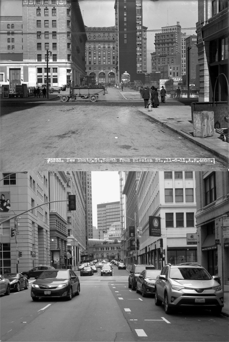 New Montgomery Street, looking north toward Mission Street in 1911: The Palace Hotel, which is the prominent building on the left in the vintage photo, can just barely be seen from here today. The Number One Montgomery Building, built in 1908 and seen in the far background in my picture, had its top portion removed in the 1970s. It angles differently and appears farther away than the old building on the corner of Market and Montgomery Streets in the vintage picture because they’re not on the same block. The old Crocker Building in the background of the old photo was demolished and Number One Montgomery is actually on the corner of Post and Montgomery Streets, which cuts in a different direction. (San Francisco Pictures / SFMTA Photo Archives)
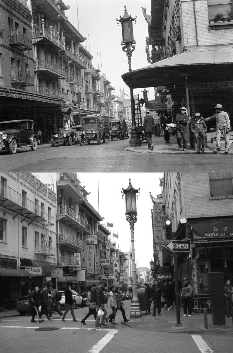 Grant Avenue at Washington Street: The blog lists the vintage picture as from 1920. I’m sure I’m standing in the same spot, but the old and same buildings on the west side of Grant Avenue on the left don’t line up. I’ll put it down to an optical illusion. (San Francisco Pictures)
 Mason and Sacramento Streets looking east in 1956: Sometimes I’ll do an update photo and think I got the picture at just the right spot, and then when I put it together with the vintage picture I’ll say to myself, “Darn, I should have been more to the left!” or “Darn, I should have been more to the right!” or “Darn, I should have been closer!” or “Darn, I should have been farther back!”. I don’t always say “darn” either. I missed this one, alright. I should have been farther out in the intersection, but it’s a busy crossing and I never get a good line up when I’m looking back over my shoulder while I take the picture. (San Francisco Pictures)
 Washington Street at Hyde looking east in 1957: I got a pretty good line up on this one, but that’s not the interesting thing about the picture. The Washington Street cable car line used to run west past Hyde Street all the way to Steiner Street. The line had been discontinued by 1957 but you can still see the cable car tracks at the bottom of the vintage picture. (San Francisco Pictures / SFMTA Photo Archives)
 Looking north along Hyde Street in 1957 from the same intersection at Washington Street as the previous picture: Trees block most of the view along Hyde Street today. The vintage picture was probably taken from the back of a cable car, and the tracks curve a little differently today due to the O’Farrell Line that used to continue south along Hyde as far as Pine Street once, and the cable car overhaul of 1982 and 1983. (San Francisco Pictures / SFMTA Photo Archives)
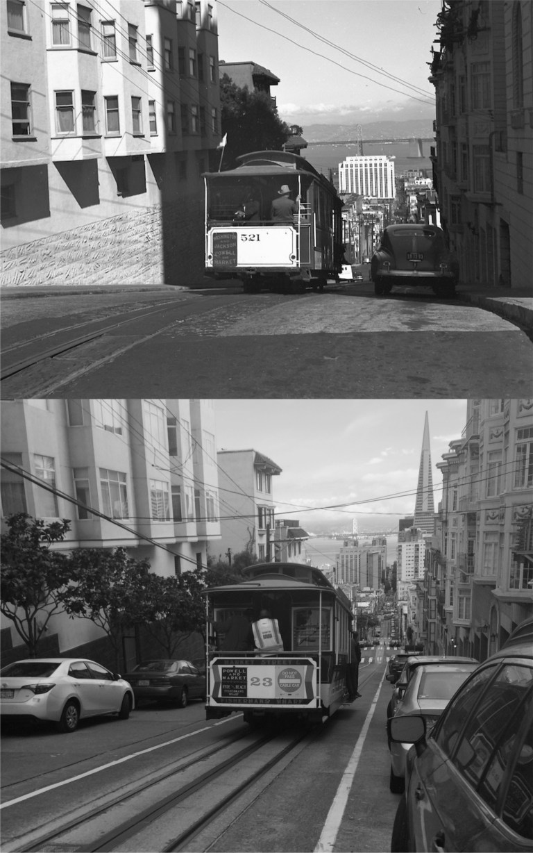 A cable car plunging down Washington Street from Jones in 1947: I gave it a try; “Close but no cigar”, or cigarette, or even a vape! (San Francisco Pictures / SFMTA Photo Archives)
 Jones Street looking south toward Post Street in 1913: This one was a pleasant surprise; usually I’m not far enough out into traffic when I take my picture, on this one I was too far out in the street. The construction work on Post Street was probably for the laying of streetcar tracks that by then began to replace cable car lines. However, you can still see the Jones Street cable car lines heading up Nob Hill. Good 1913 advertising; I suddenly have a craving for a stick of Wrigley’s Spearmint Gum! (San Francisco Pictures / SFMTA Photo Archives)
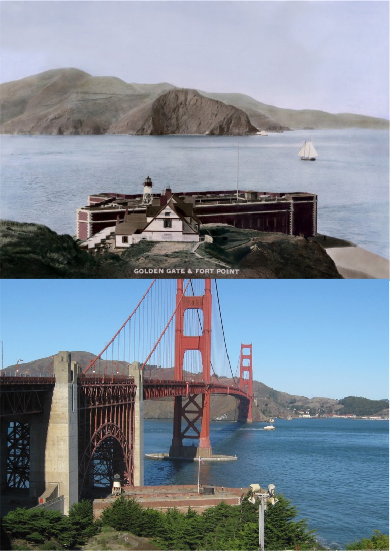 The Golden Gate and Fort Point in the 1880s:
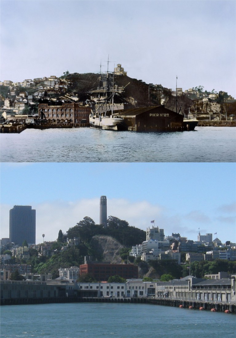 The San Francisco waterfront beneath Telegraph Hill in 1885 before the Embarcadero Piers were built: Dynamite blasting of Telegraph Hill in the late Nineteenth Century, particularly by the brothers George and Harry Gray for their stone quarry, removed the natural slope of the eastern side of the hill before it was stopped early in the Twentieth Century. You can see the damage the Gray Brothers caused in my picture.
 The area that used to be called Meiggs Wharf but is today’s northern waterfront and Fisherman’s Wharf in the 1870s: Alcatraz Island, the Tiburon Peninsula, Angel Island and Sausalito can be seen in both pictures.
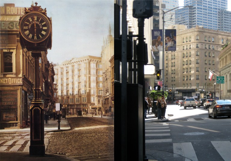 Montgomery Street at Sutter looking south toward the old Palace Hotel in the late 1870s:
 The waterfront looking down from Telegraph Hill in 1865:
 The Vallejo Street Wharf looking toward Telegraph Hill in 1866: Much of this area has been filled in now.
 Looking down from Telegraph Hill toward Vallejo Street and Broadway, where most of the ships docked back in 1865:
 The wharf near Broadway, the opposite view of the previous photos, looking back toward Telegraph Hill: The picture is dated 1850, which would make it one of the oldest pictures or daguerreotypes of San Francisco known.