Also, taking the long way to the top of Coit Tower

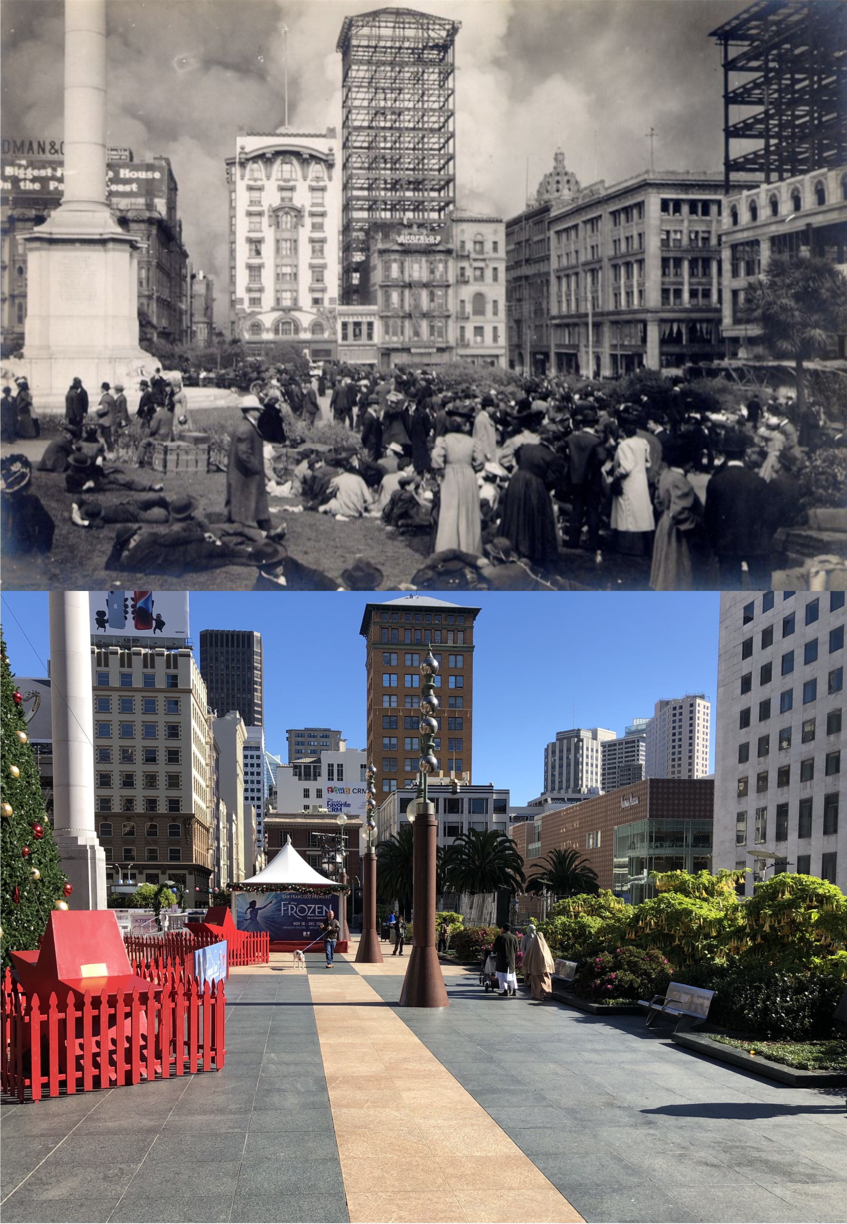
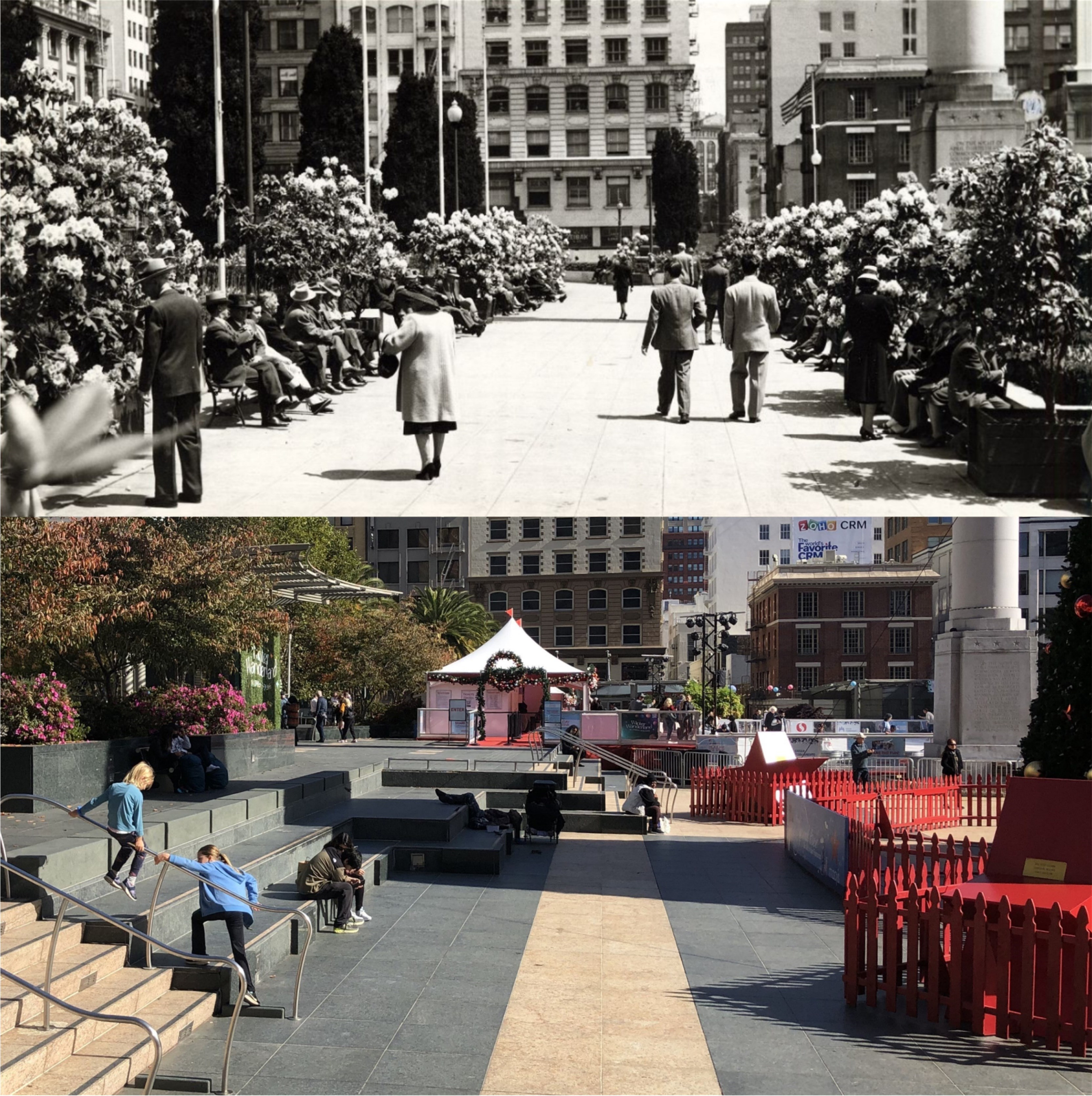
The title is in reference to my November 13th 2022 post, although this diversion wasn’t planned. Last Thursday, I thought I’d take another trip to Coit Tower. It was a clear day, and I decided to take pictures around the observation deck of the tower. To my disappointment, the elevator to the top of the tower was out of order, but one of the assistants said that if I bought a ticket, I could take the stairs to the top. I’ve been to Coit Tower many, many times, but I have never taken the often heard of closed off stairway to the top, so, I thought I’d give it a try. The stairway circles continuously around the inside of Coit Tower until it reaches the top. When I reached Level 4, I wasn’t sure that this was such a good idea, but I wasn’t going to back out in front of the tower employees. Besides, several much younger people than I am had gone on ahead, and I wasn’t going to let them show me up. When I reached Level 10, I felt like I was pretty much done for the day, and when I stumbled out at the top, I felt like I was about a hundred years old! After I took my pictures, I realized that descending down the steep stairway is almost as tiring! When I got back down, one of the ladies working there remarked, “Well, I’ll bet that’s something you haven’t done before.” and she was right; that’s something I hadn’t done before, or won’t ever do again! I stopped by Calhoun Terrace to take some pictures, and headed down the Filbert Steps, which didn’t seem like much of a bother now, to the bottom of Telegraph Hill. When I got to my office, I tried to match up my pictures with some slides from the top of Coit Tower that I took in 1983. (Thumbnail images)

In April of 1983, I snapped a picture of a tanker heading past the Embarcadero, and heading toward the Bay Bridge. When I saw a ship approaching the Bay Bridge, remembered my 1983 slide because it’s one of my favorites, and took pictures of the ship passing by Telegraph. On the third one, I got a near perfect lineup with my old slide.

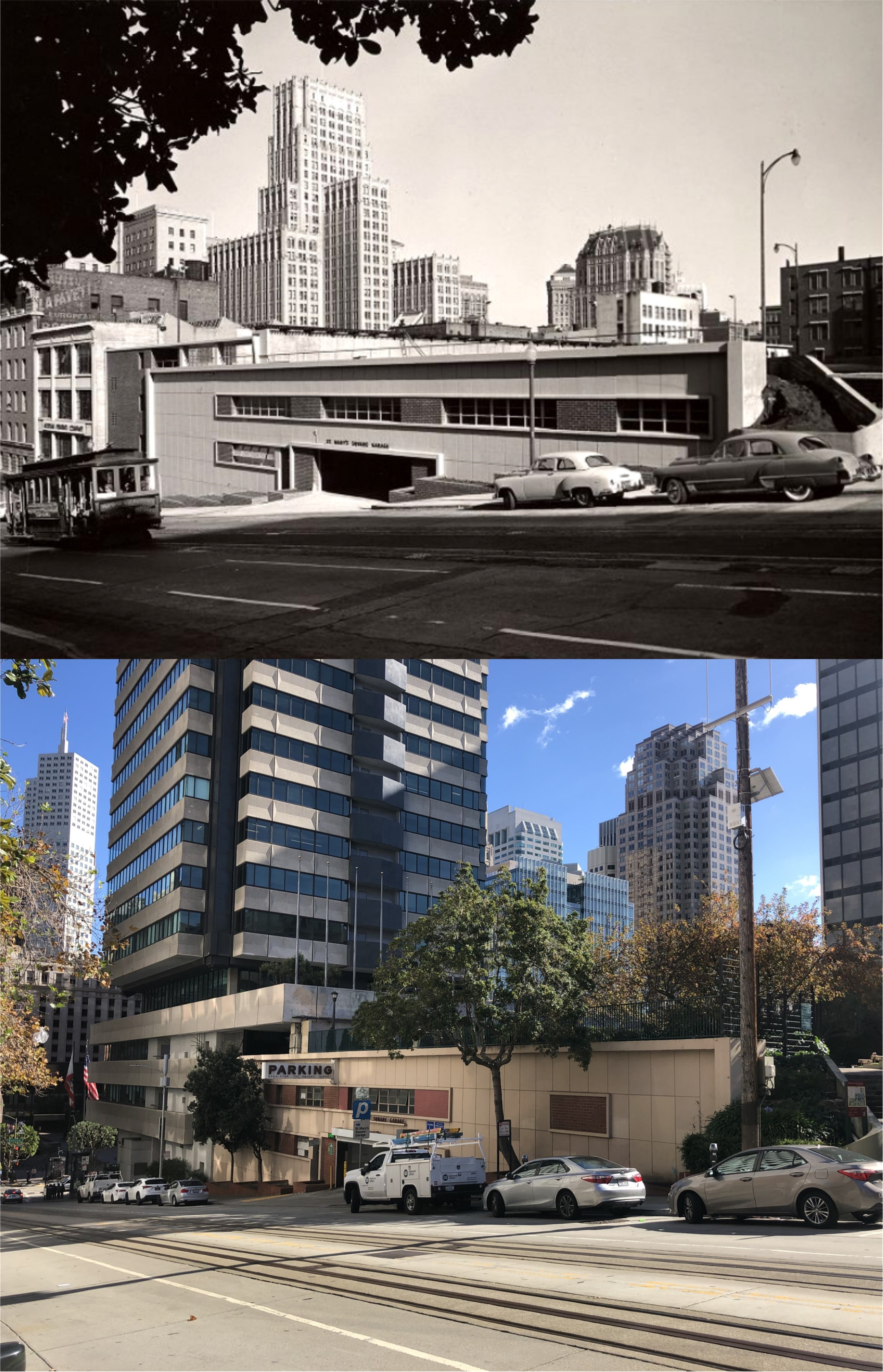
I took the rest of my pictures through the windows of the tower, like this one showing the old Embarcadero Freeway. They don’t match up perfectly with my old slides, but they still make interesting comparisons.

Looking toward Downtown San Francisco: Except for the Pyramid Building, this one doesn’t match up at all. The Salesforce Tower, looming in the background through the haze, is actually much taller than the Transamerica Pyramid.

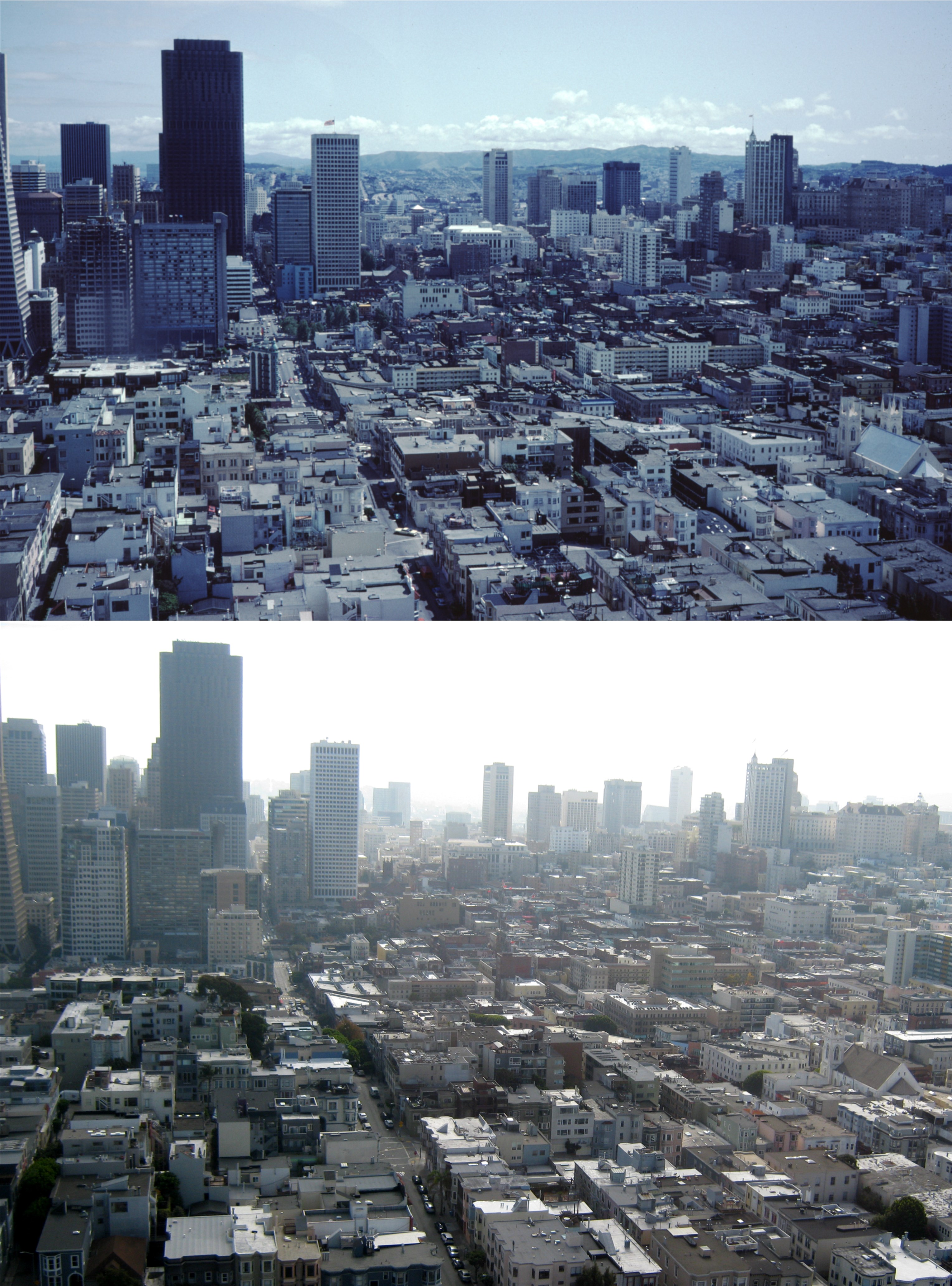
Now you’re looking across Chinatown, with Nob Hill on the right and the Bank of America Building on the left.

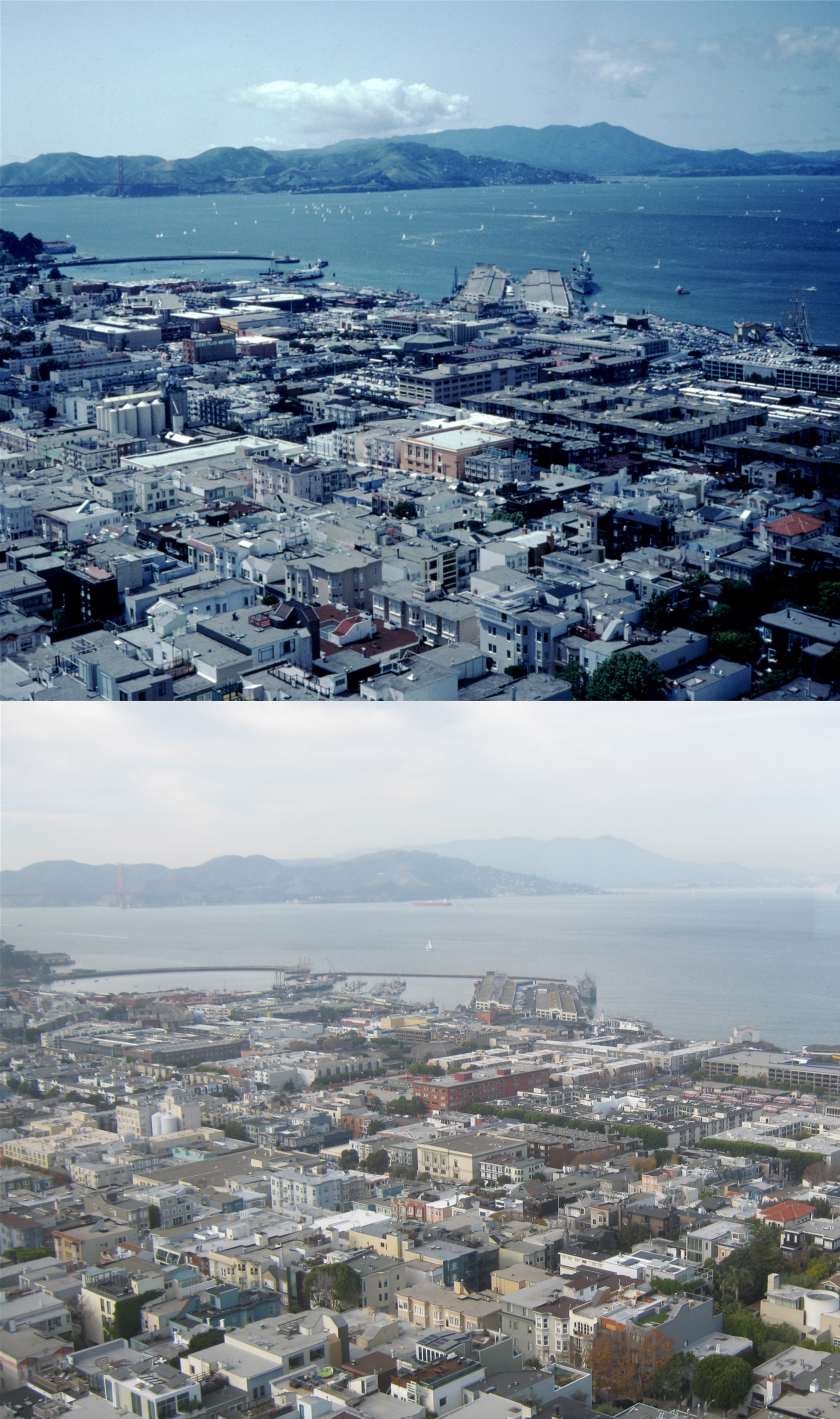
Looking toward Fisherman’s Wharf and Pier 45, with the Van Ness Pier on the left. The ship docked at Pier 45 in the 1983 pictures isn’t the Liberty Ship, the Jeremiah O’Brien, docked there today. On the right, you can see the arch of Pier 43 in both pictures. The sailing ship, the Balclutha, was still docked at Pier 43 in 1983.

After I left Coit Tower, I walked down the Filbert Steps to Calhoun Terrace, and another one of my all time favorite San Francisco views. You’re looking down toward Pier 17 on the Embarcadero. The Exploratorium is now housed in Pier 17. Back in 1983, somebody had the silly idea to paint the Embarcadero Piers mellow yellow and baby blue. Thankfully, they’ve been repainted since them. Yerba Buena and Treasure Islands, and the tower of the Bay Bridge eastern span are in the background.

The view further south of the previous pictures shows the Pier 7 walking pier at the foot of Broadway. The Pier 7 Building had been removed by 1983.

Last, is another view of the gone but not forgiven Embarcadero Freeway. I have to admit that I used that freeway often, and I was one of the last people on it before it closed forever, trying to get out of San Francisco during the hours after the October 17th 1989 Loma Prieta Earthquake, but I don’t miss it.


My last day at the terminal, Terminal

I not only wanted to be there, I had to be there in August of 2010 on the last day of service at the Transbay Terminal on Mission Street. Built in 1939, this transportation hub was my introduction to San Francisco at age 15 when my buddies and I learned how to take a bus from Castro Valley into the City. It was always a long trip there and back, involving a transfer of buses, but the magic feeling at the sight of the inside of the Transbay Terminal was as exciting as the view of the Disneyland Matterhorn was as a kid after a long drive with my family from Northern California. From the Terminal, my friends and I discovered Golden Gate Park, Playland-at-the-Beach, the Cliff House, Chinatown, Fisherman’s Wharf, the Embarcadero, Telegraph Hill and Coit Tower, cable cars…… oh, don’t get me started. Too late! The building was already old when I discovered it, and it’s amazing that it still lasted for decades after that. These are then and thens of pictures I recently found from the San Francisco Public Library archives in comparison to some of the pictures I took the day before the Transbay Terminal closed forever. (Thumbnail images)

The view of the Transbay Terminal during the 1950s from the northeast corner of Mission and Fremont Streets:

The third level of the terminal where the trains and buses loaded and unloaded passengers, showing the tracks of the Key System Train Service:

Passengers boarding one of the Key System trains that traveled to and from the East Bay Area by way of the lower deck of the Bay Bridge:

One of the ramps leading up to the third level of the Transbay Terminal: There must have been something pretty exciting going on in the East Bay when the vintage picture was taken.

Long ago ladies going down the stairs to the first level of the terminal, and my picture I took of one of the stairs leading down to the mezzanine: I’m assuming that they got off the train; when you’re dressed like that you don’t have to take a bus.

People packing into one of the buses on the third level, looks like the 1960s or early 1970s, and one lonely looking passenger boarding a bus on the last day of service in August of 2010:


Some of the people who’ll miss the Transbay Terminal posted comments on the Market Street Railway internet page, like this person.

Taking the long way to Tad’s (For Tad’s Steak House)

Yesterday, I headed over to San Francisco on BART for a breakfast at Tad’s Steak House on Ellis Street. If I get off at the Powell Street BART Station, I’m only about two minutes on foot to Tad’s. Knowing that I was planning on tackling a high cholesterol and unhealthy breakfast, I decided to take a roundabout way to Tad’s to get a little exercise first, and take a few pictures I’ve wanted get along the way. I got off BART two stops early at the Embarcadero Station, walked along Drumm to Sacramento Street, and caught the Muni #1 bus up the hill to Grant Avenue, Chinatown, and started heading back to Tad’s. (Thumbnail images)

At California Street I was able to update a 1950s picture of the St. Mary’s Square Garage. Some of the buildings you can see behind the garage in the vintage picture from left to right are the tall Russ Building, the Hobart Building, and the Hunter-Dulin Building with its Gothic looking roof. All of these are blocked now by buildings I couldn’t name if I had to. (San Francisco Public Library Archives)

I doubled back to Grant Avenue through St. Mary’s Square, the most peaceful spot in Chinatown. I love that little park, and I’ve never seen it as crowded as in this photo that looks like it’s from the 1940s. During World War Two, Madame Chiang Kai-shek, easily the most famous Asian woman in the world at that time, paid a visit to St. Mary’s Square. . (San Francisco Public Library Archives)

Leaving Chinatown, I moved down Grant Avenue to Maiden Lane, cut through to Stockton Street, and double back to Post Street to get this update of a 1940s picture taken at the northeast corner of Union Square. . (San Francisco Public Library Archives)

I crossed through Union Square to Powell Street, and walked down the west side of Powell to update this late 1950s picture from the San Francisco Remembered Facebook page of two ladies passing by Tad’s Steak House at 120 Powell Street, where the restaurant originally opened in 1955. In 2019, Tad’s closed on Powell Street, and moved around the corner to Ellis Street. Tad’s was right behind where the couple with the child in my picture were.

Ah, I’m getting closer and hungrier. I’m happy to say that the neon Tad’s Steaks sign made the move to Ellis, as well.

When I finished my breakfast and left Tad’s, I crossed over to Ellis Street at Powell, doubled back along Ellis to Market Street, and walked back along Market to the Powell Street BART Station. On the way, I did an update of the old clock across Market Street from the Emporium Building where the Bloomfield Shopping Center is now. The clock is not accurate nowadays, it was not 8:40. Before I left, I looked at the walking tracker app on my iPhone and found that I covered 2.6 miles on my journey. That ought to be enough exercise to offset eggs over easy, link sausages, hash browns, and toast.

‘Tis the season

Union Square is getting all decked out for the Holiday Season again. Once again, this little park will become probably the busiest shopping area in Northern California. Police presence will increase to deter smash-and-grabbers, and even those who avoid San Francisco because they fear the city is full of Commies and heathens, will come to Union Square to revive that Christmas feeling. After Fifth Avenue in New York City, Union Square may be the best urban area in the country to capture that ‘Miracle on 34th Street’ atmosphere.The vintage pictures are from the San Francisco Public Library Archives (Thumbnail images)

Dazed people gathering in Union Square just after the 1906 Earthquake: The Dewey Monument is on the left. The steel framed building under construction in the center of the old photo was completed after the disaster and is still there. The crown of the Call Building can be seen peeking out over the top of the original City of Paris Building, and is now the remodeled Central Tower behind Neiman Marcus.

The southeast corner of Union Square at Geary and Stockton Streets during World War Two: Hmmm, would I have bought War Bonds or Old Sunny Brook Whiskey?

The north side of Union Square, looking toward Maiden Lane during the 1940s:

Looking toward the St. Francis Hotel and some temporary Alpine Village on display during the 1970s:

Looking over the eastern side of Union Square toward Stockton Street and Maiden Lane during the 1950s: The November shadows kind of screwed my picture up a little, but it was the closest I could get to where the vintage photo was taken from. The ice skating rink on the left in my photo is getting ready to open for the 2022 Season.

Segue to November, 2022

All of these updates, except the black and white California and Sansome one, I did during the last week of October. The weather was perfect; “Second Summer” weather, in what used to be called an “Indian Summer”, made for a pleasant wrap up of my October, 2022 posts. The last update I did on November 1st, was when the weather turned suddenly cold and ugly. I took that to be nature’s way of warning us that winter is coming, but we still have nearly two more months of autumn, so I’m not going to take yesterday too seriously. The vintage pictures are from the San Francisco Public Library Archives. (Thumbnail Images)

The old Steinhart Aquarium and the Academy of Sciences in Golden Gate Park, demolished in 2005. I don’t know when the vintage picture was taken, but it was before the Sutro was built in 1973. I first visited Steinhart Aquarium on a field trip in the 6th grade. I bought a baby octopus preserved in a jar of formaldehyde and water. While the rest of the kids bragged about their new bike or skateboard, I had an octopus! The kids on the block “got nothin’ on this baby.”

The Number One Powell Street Building, originally the Bank of Italy Building, completed in 1920: The cable car turntable here is not in the same location today as it was when the vintage picture was taken, so I had to use a wider picture to get a cable car in.

Bush Street, between Sansome and Battery Streets, in the 1920s: I’ve always been intrigued by that thin little building with the advertising at 130 Bush Street, but I don’t know much about it, except that it was probably build in 1910, and the rumor isn’t true that only skinny people can work there. You can just see it today, squeezed in even more by the Shell Building that was constructed in 1930.

The old Audiffred Building on the corner of Mission and Steuart Streets, originally constructed in 1889: On “Bloody Thursday” during the 1934 water front strike, two strikers were shot to death on the Mission Street side of the building, which is around the corner on the right side of the pictures.

I got a pretty good line up on this one at Geary Blvd. and Powell Street, next to the St Francis Hotel looking toward Union Square. I’m not sure what those marks on the old photo were all about.

California Street at Sansome in the 1940s: Black and white’s better when wet; rain doesn’t color well. Fortunately there was a regular break in traffic on California Street due to street lights, so I was able to get a shot between the cable car tracks. Although not a ghost town, the Financial District still hasn’t come back all of the way from Covid 19.