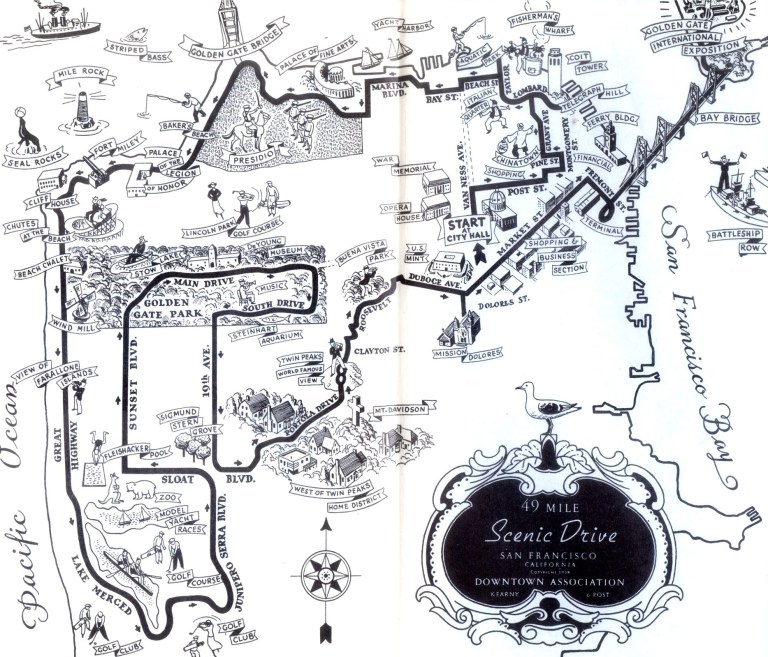
Who says that you can’t see all of San Francisco in one day? In 1938 the Downtown Association of San Francisco established the 49 Mile Scenic Drive. The drive still exists today although it varies in several locations from the original route. Above, is a 1939 map of the Scenic Drive from Elizabeth Gray Potter’s book ‘The San Francisco Skyline’. Let’s take a drive along the forty nine miles and I’ll point out where the route differs today.
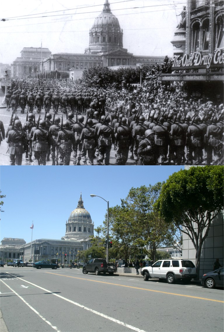 The old map starts a City Hall and that’s where we’ll start. Here, victorious army soldiers march along Grove Street past Larkin at the end of World War Two. The Owl Drug Store building on the right in the vintage photo is now where the San Francisco Main Library is. The old route heads north on Van Ness turning east on Post, but today the drive heads along Larkin Street turning west at Geary Blvd. to Japantown before heading back east along Post.
 We’re traveling east along Post St. past Union Square. At Post and Stockton there was a military display in 1943.
 We’ll turn north on Montgomery Street and then double back into Chinatown. Here, we’re at Montgomery Street, the “Wall Street of the West”.
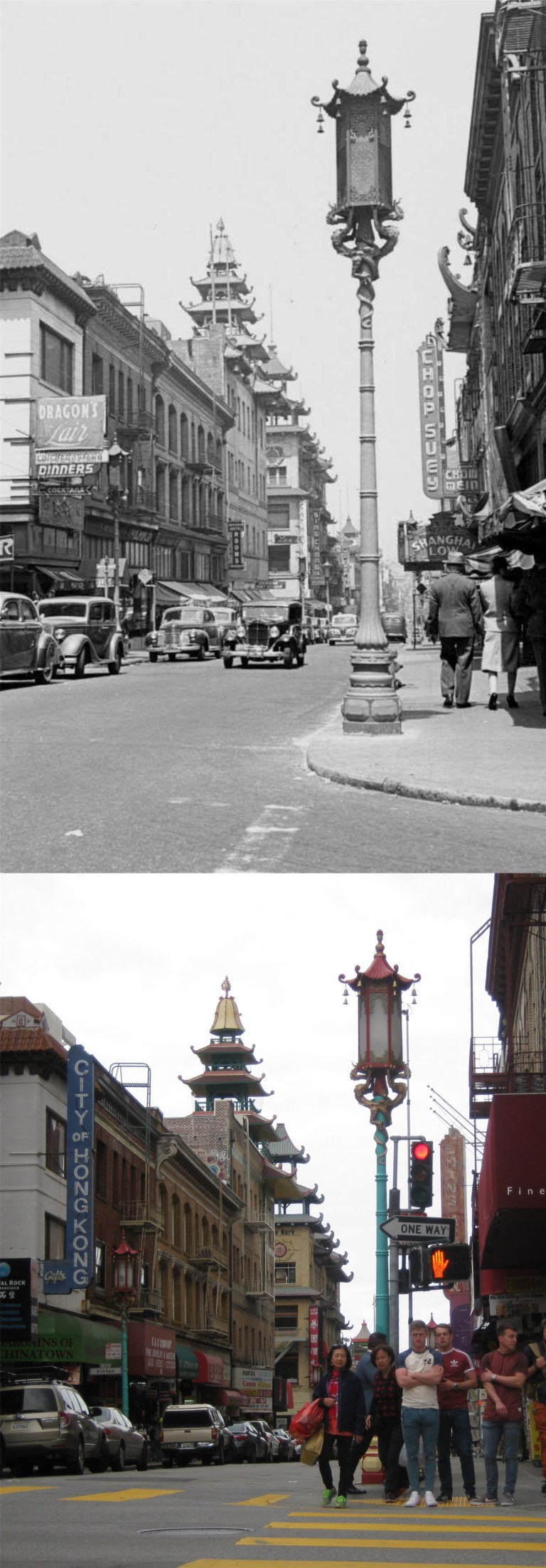 We travel awhile through Chinatown, seen here at Pine Street and Grant Avenue, but the old route doesn’t appear to climb up Nob Hill after leaving Chinatown as it does today.
 Next, we visit Lombard Street, the “Crookedest Street in the World”
 Both then and today, the 49 Mile Scenic drive heads up to Coit Tower. The top photo is from a 1960’s postcard. Either the trees have grown bigger or Coit tower has gotten smaller!
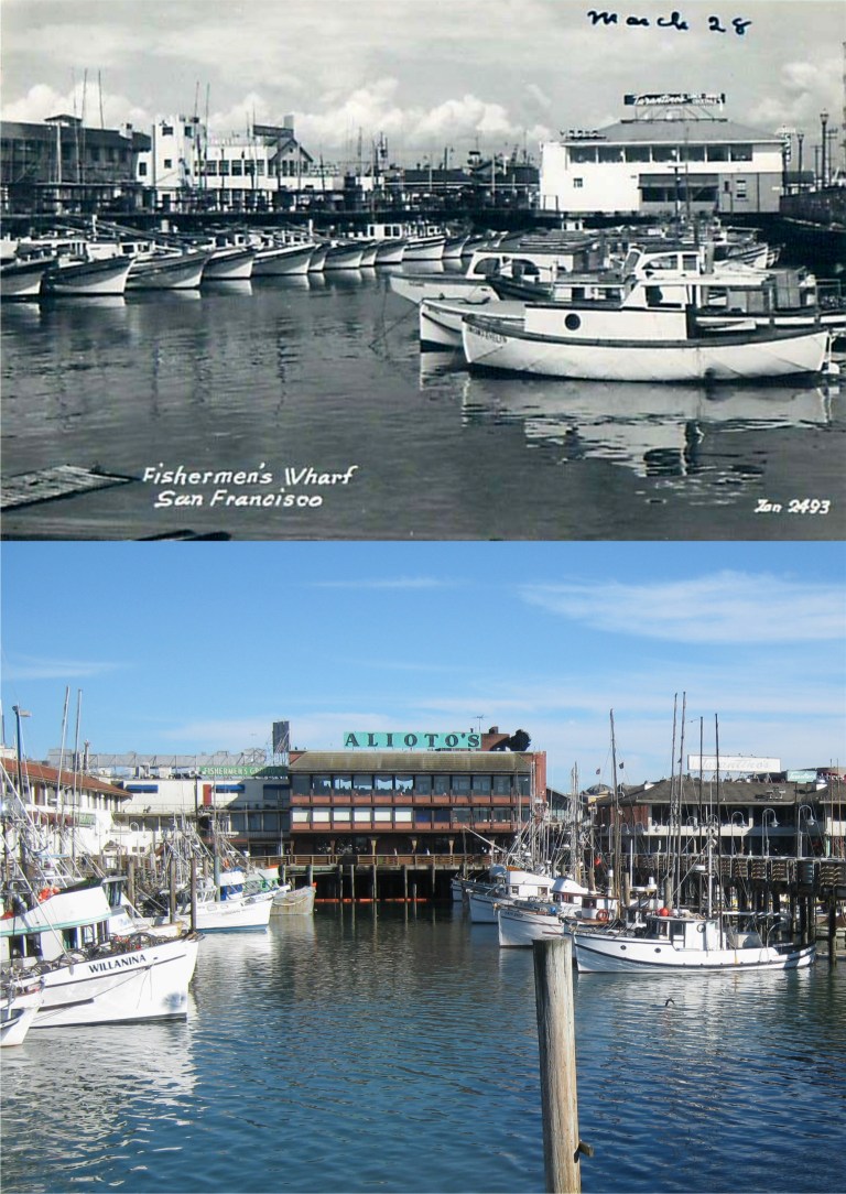 We continue north for a stop at Fisherman’s Wharf, the busiest tourist attraction in California after Disneyland. (They spelled it wrong!)
 Now the drive route heads west past the Marina and enters into the Presidio at the Palace of Fine Arts Building, the only survivor of the Panama Pacific International Exposition of 1915. It’s a long drive so we’ll stop and rest here with Janis for a moment.
 On to the Golden Gate Bridge! The top image above is from Alfred Hitchcock’s 1958 film ‘Vertigo’. Kim Novac throws a bouquet of flowers into the Bay before jumping in herself only to be rescued by Jimmy Stewart. This is as close at you can get to the spot today since 9/11.
 The Scenic Drive skirts Baker Beach seen here in a vintage picture of a wounded soldier with a child after World War Two.
 We’ll continue west through Lincoln Park past the Palace of the Legion of Honor.
 Along Point Lobos Drive we turn south at the Cliff House and head down to the Great Highway.
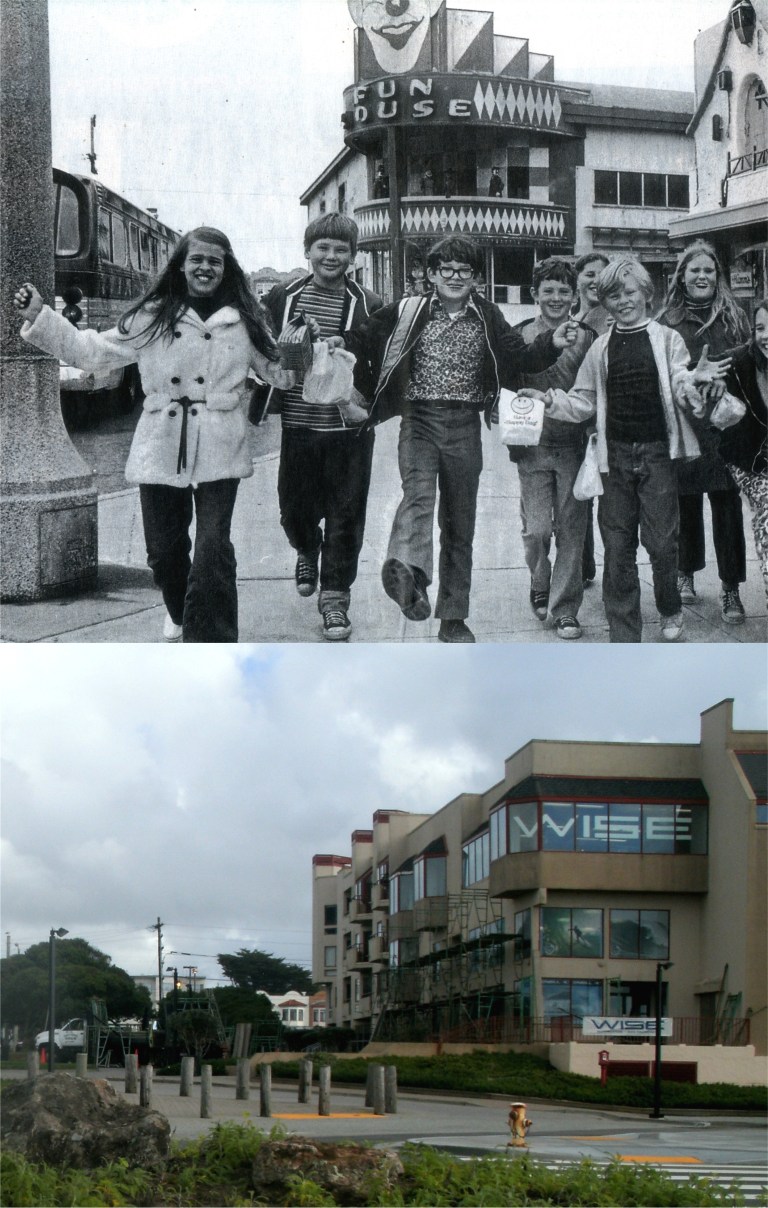 Playland-at-the-Beach was apparently still referred to as Chutes at the Beach in 1939. The early 1970’s picture from the San Francisco Chronicle shows children at the Funhouse shortly before Playland was demolished. The Funhouse was where the building with the Wise signs on it is today. Scenes from the 1948 move ‘The Lady from Shanghai’ starring Orson Welles and Rita Hayworth were filmed here.
 We’re traveling down the Great Highway now along with Charlie Chaplin in his 1915 movie ‘Jitney Elopement’ Here, Charlie backs into the car of a villain pursuing him on an unpaved Great Highway. Here’s the spot today.
 Both the 1939 route and today’s travel past where the old Fleishhacker’s Pool, the largest swimming pool in the world when it was built, once existed. That’s my seventeen year old mom on the left swimming with her cousin Frances in the pool during a visit from North Dakota in 1939, the same year as the old Scenic Drive Map. Fleishhacker’s Pool closed in 1971 and was filled in. It is now under the parking lot of the San Francisco Zoo. They spelled Fleishhacker’s wrong on the old tour map too. Oh, well, nobody’s perfect! “Tell us about it, Tim.”
 As we circle around Lake Merced we’ll travel past the spot where the last duel in California took place in 1859. Senator Broderick came up with the short end of the stick. The concrete markers are where the two men stood before firing.
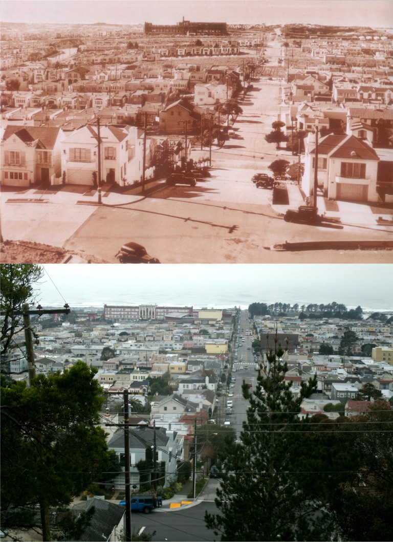 After Lake Merced the 49 Mile Scenic drive heads north along Sunset Blvd. to Golden Gate Park. Let’s stop for a breathtaking view of the Sunset District at Quintara and 15th. The vintage tinted photo is from Bill Yenne’s terrific collection of then and now San Francisco pictures.
 The 49 mile drive enters Golden Gate Park and passes many of the park’s attractions including the De Young Museum seen here in the old photo with my mom on the right during her 1939 visit. The old museum building was demolished and rebuilt and this is entrance to the De Young Museum today.
 The first major variation from the 1939 Scenic Drive is in leaving Golden Gate Park. Back then the drive exited the park at 19th Ave. going south to Sloat Blvd. then follows Portola Drive to Twin Peaks. In the vintage picture an unfortunate driver is getting a ticket in front of the original Shriner Hospital Building on 19th Ave. I wonder how much it cost him. Today’s Scenic Drive exits the Park at Stanyan traveling past the Haight-Ashbury area then follows 7th Ave. to Portola Drive and up to Twin Peaks. Lovely Stern Grove is forgotten.
 The view from Twin Peaks, one of the best shows in the house, during the 1950’s and today:
 After leaving Twin Peaks, the tour drive follows basically the same route to Mission Dolores, seen in the top picture in Alfred Hitchcock’s ‘Vertigo’.
 After Mission Dolores none of the original route is used today. The Scenic Drive travels past Dolores Park to Cesar Chavez Street to Highway 280, passes AT&T Park and the Ferry Building, and then doubles back to City Hall by way of Howard Street completely bypassing Market Street. In the top photo from Hannah Clayborn’s collection Roman Rodriguez, sitting on the lawn, reconstructs his murder of 16 year old Hilda Pagan to the police at Dolores Park in 1952. I can’t get much information on this murder today and I wonder who the lady with her hands to her face was? I hope it wasn’t Hilda’s mother. A top portion was added to the small building they sat at, and it was a restroom and snack bar when I took my photo several years ago. It was demolished during the 2015 remodeling of Dolores.
 Back to the 1939 route: We’re on Market Street, near the Palace Hotel. The top picture is from the famous 1906 film ‘A Trip Down Market Street’. A portion of the old Palace Hotel, destroyed during the 1906 Earthquake and Fire, can be seen on the right in the film photo.
 The 1939 route bypasses the Ferry Building, (How rude was that?) for the more traveled by that time Trans Bay Terminal. The top pictures are of a bus leaving inside the terminal in a scene from the 1973 film ‘The Laughing Policeman’ and a bus leaving the terminal on the day the building closed in August of 2010.
 From here we’re on our way to the Fair across the Bay Bridge, seen in the opening shot of the Humphrey Bogart movie ‘The Maltese Falcon’.
 We’ll end up at the 1939 Golden Gate International Exposition on Treasure Island. The top picture is from a short color film entitled ‘The Cavalcade of San Francisco’ narrated by James Fitxpatrick. That was a long drive, I’m tired!
 I’ll close with a photo of today’s 49 Mile Scenic Drive for comparison.

 24th Avenue and Taraval Street looking east in 1962:
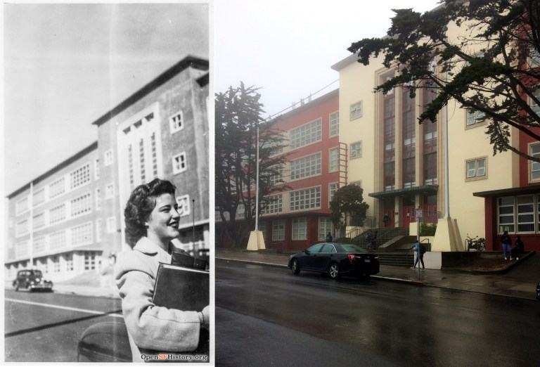 What high school girls looked like in 1943 at the old Lincoln High School on 24th Avenue:
 Taraval Street and 24th Avenue looking west in 1949: The old L Line survives.
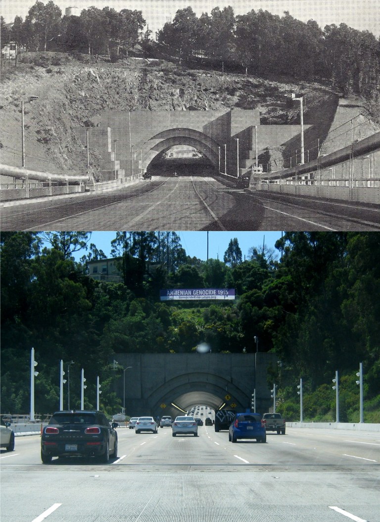 Coming and going, the east and west side of Yerba Buena Tunnel: Traffic was a lot lighter on the bridge when they took the old picture.
 Headed out to the ocean through Golden Gate Park past the McLaren Lodge:
 I’m taking “the road not taken” in Golden Gate Park. It looks like there was a lot of storm damage in this part of the park!
 Rounding Point Lobos I was lucky to find a parking spot at the beach. Once again had the same idea that several million other people had! (OpenSFHistory.org)
 The tide behind the Cliff House was as low as I’ve ever seen it!
 The old photo is how it usually looks at Seal Rocks, but yesterday I was able to get as close to Seal Rocks as I’ve ever been, maybe about a hundred feet! I hope they aren’t radioactive like the Farallon Islands are supposed to be!
 You don’t get a chance to walk completely around the Cliff House that often.
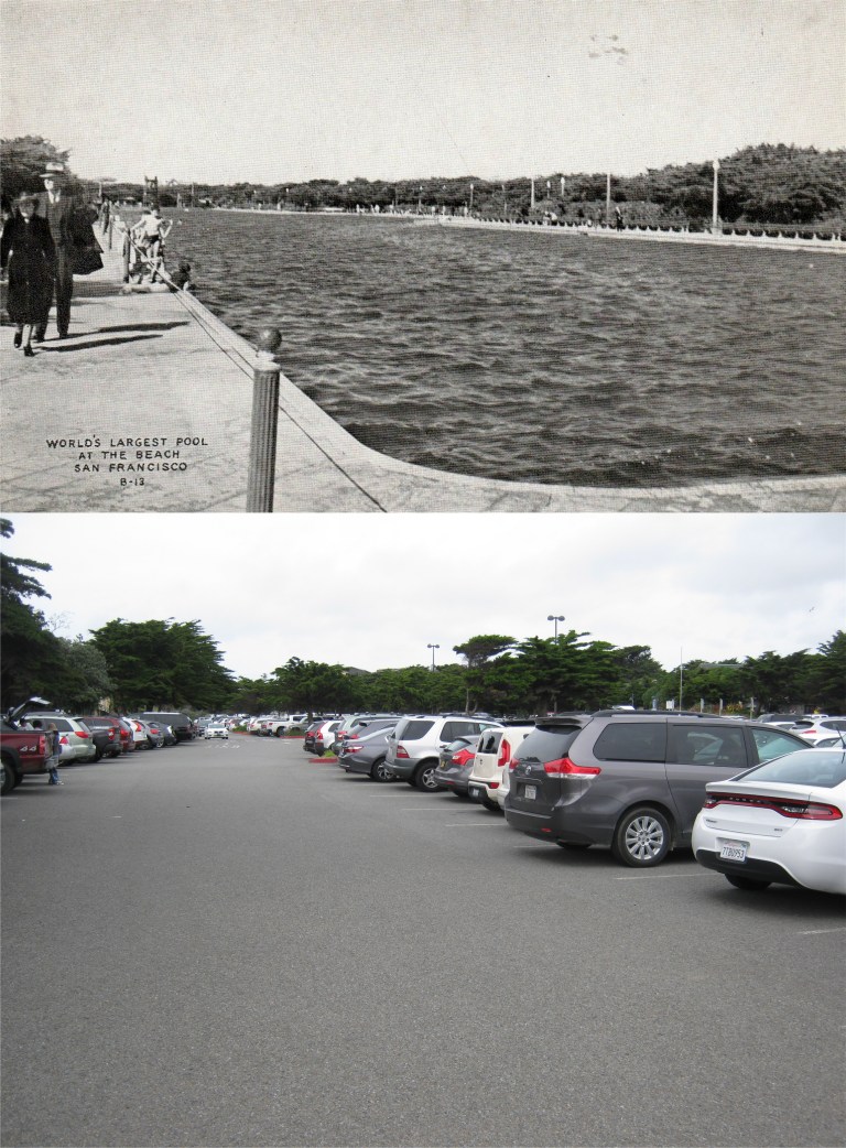 Saturday I spent time mostly around the southwest side of town. There’s a lot of interesting things to enjoy around there; the Urbano Sundial, Fort Funston, and the San Francisco Zoo to mention a few. What was once the largest swimming pool in the world is now buried beneath the San Francisco Zoo Parking lot.
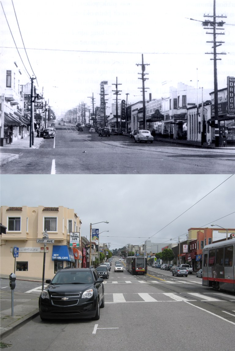 The most commercial street in the lower Sunset District is Taraval Street but I don’t get over there too often, and it has its own flavor. This is looking east at Taraval and 21st Avenue. (Vintage photo from the Jack Tillmany Collection)
 It might have been nice to have Lombard Street all to myself like in the 1957 photo at the top, but this is one spot where crowds make it more fun; unless, of course, you live on Lombard. (opensfhistory.org)
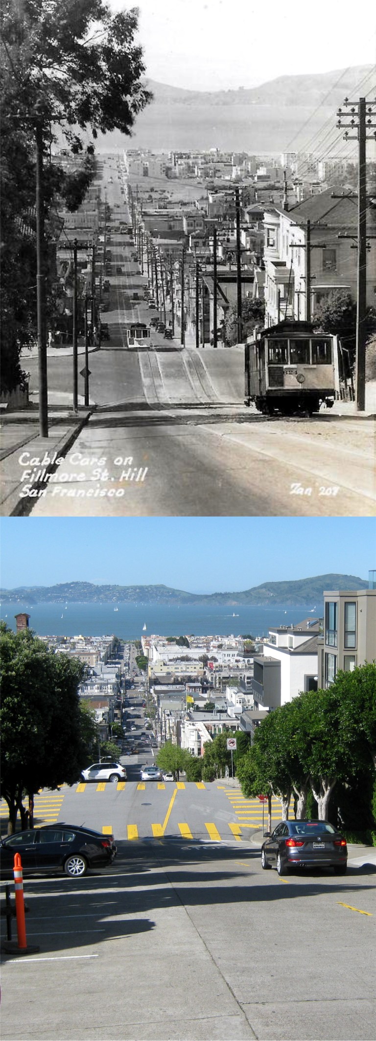 Fillmore Street above Vallejo Street when cable cars climbed the hill:
 The old Dutch Windmill at the northwest corner of Golden Gate Park: It’s a lot tidier here today.
 I’ve covered in previous posts the old stone bridge at the southwest corner of Golden Gate Park where streetcars crossed over, but on the northwest corner across the park from where the stone bridge once stood there can still be found a little known tunnel that the trains passed through as they made their way across the western side of the park. (opensfhistory.org)
 “Been there, done that!” At the top is a slide picture that I took in 1983 looking down Broadway from Russian Hill and the same spot today. It’s weird how little this view has changed!