The Four Star Theater (For the WNP Film Club and Bay Area Movies)

The Western Neighbor Project, in partnership with Cinema SF, and Bay Area Movies were kind enough to compliment me on my website, and invite me to their screening of the 1964 film ‘Good Neighbor Sam’. They’ll be showing the movie at the Four Star Theater at 23rd Avenue and Clement Street this coming Thursday, May 28th. I’ve never been in the Four Star Theater, and I’m looking forward to the evening. I looked up some vintage photos of the movie theater, and went over there today to take some pictures. Wow, ‘Raising Arizona’ was playing! I thought that movie was hilarious when I first saw it. (Thumbnail images)


The Four Star Theater originally opened in 1913 as the La Bonita Theater, The vintage picture was taken in 1919. (San Francisco Library Digital Library Archives)


Looking west on Clement Street in 1949: Lincoln Park is in the far background of both pictures. In 1927, the theater name was changed to the Star Theater, and in the late 1940s, the Four Star Theater. (opensfhistory.org)


The Four Star Theater in August of 1964, in an Alan Canterbury photo from the San Francisco Digital Library Archives. Last Fall, I did several posts on photographs by Alan Canterbury. (San Francisco Library Digital Library Archives)


The Four Star Theater in 1969; Langendorf Bread, RC Cola, and a real odd couple, ‘Rosemary’s Baby’ and the ‘Odd Couple’ for a double feature: (Bay Area Historic Theaters)


The theater in 1990 in another great picture from the opensfhistory.org collection:

Charlie Chaplin Days in Niles, 2026

I went out to Niles yesterday afternoon for the second day of the three day ‘Chaplin Days’ Festival they have in the historic little town each year. I wanted to catch the 2:30 showing of his 1915 film, ‘The Champion’. It’s always a fun weekend to take pictures out there, or go on a walking tour. I took some recent shots, and re posted a few pictures from previous Niles visits. (Thumbnail images)

There was lots of Charlies running around, old vehicles, and other old things, (like me).


And even some Saguaros; it’s out west, you know. (Are they, Tony?)


Watched ‘The Champion’, along with a packed house, in the same building Chaplin premiered the film in in 1915, the Niles Museum Building.


I had a beer afterwards in one of the outdoor tables in Niles, although, not as big of a beer as Charlie’s celebration beer at the end of ‘The Champion’, and took a walk around.


Never miss a photo op. That’s the house, still there, that Edna Purviance stayed in when she was Chaplin’s leading lady in four of the five films he made while in Niles. Edna is on Charlie’s right.

In 1978, Margot Patterson Doss, a columnist who wrote articles for the San Francisco Chronicle under the title of ‘San Francisco at Your Feet’ and later in her career ‘The Bay Area at Your Feet’, wrote about the history of movies in Niles in her column entitled ‘The Movies’ One-Horse Town’. There wasn’t a lot of information available at that time about the history of Niles, and I took her Niles walk and kept her article. Here is a copy of the article, and its accompanying map. At the end of her story, Margot wrote that “only Chaplin knows” where the “tree-lined lane” at Charlie’s fade out in his film ‘The Tramp’ was. Actually, the historians from the Niles Museum have identified that spot now. Also, Charlie Chaplin died on Christmas Day of 1977; although Margot’s column on Niles appeared in 1978, it’s possible that she wrote it while Chaplin was still alive. Only Margot knows, but she’s gone now too.


‘The Champion’ was filmed at the old Essanay Movie Studio on Niles Blvd. and G Street. Here, Charlie is working out while getting ready for his big fight. Look at the mountain to the upper left of Chaplin in the film shot that I circled, and in the lower photo.


I learned about that Niles mountain view in ‘The Champion’ from John Bengtson’s book about Charlie Chaplin film locations called ‘Silent Traces’. Today, out in Niles, there was a tribute to John Bengtson who just died a few months ago.


Rincon Hill by the numbers (For Sarah)

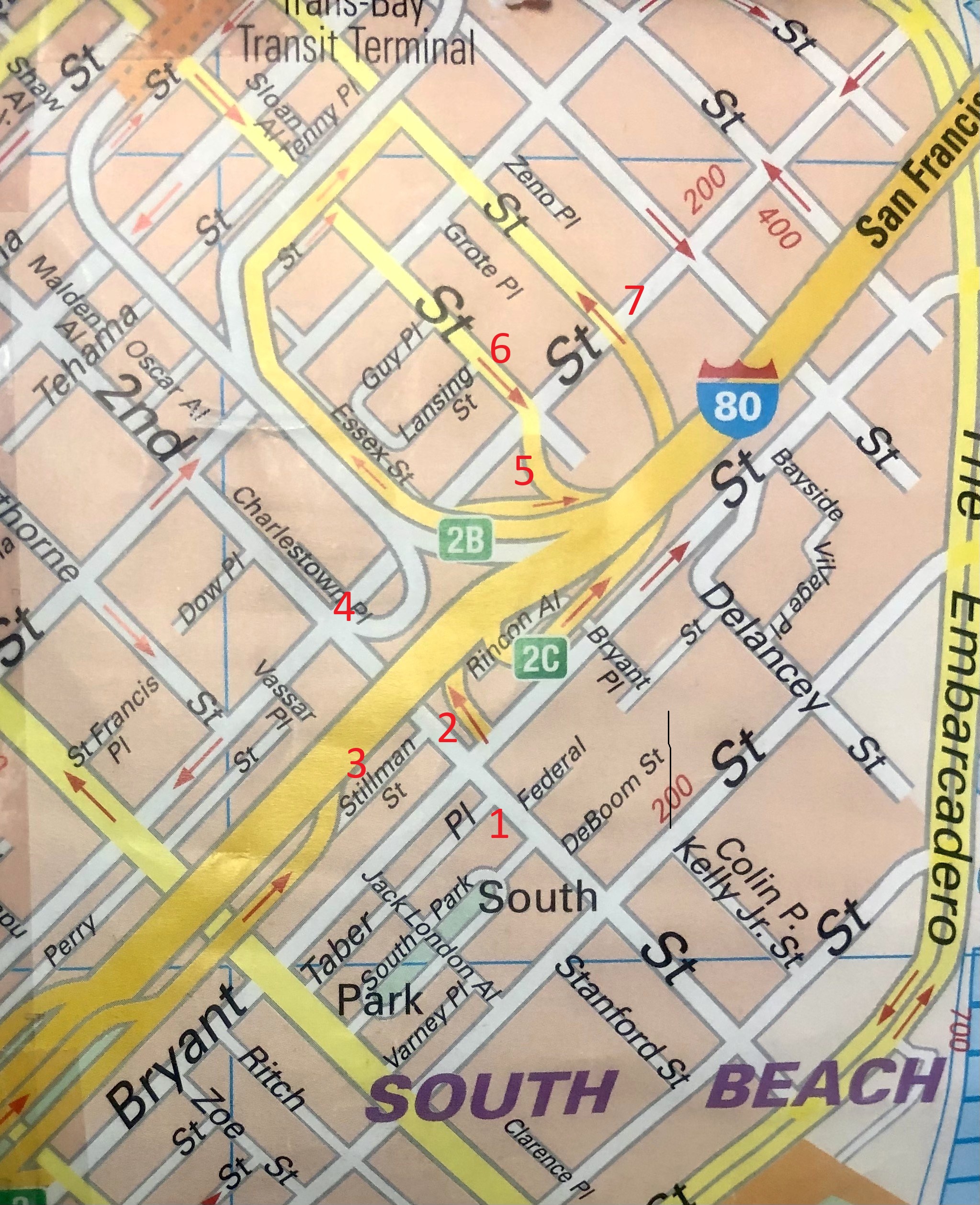
Rincon Hill, below Market Street, was originally the “Nabob” Hill of San Francisco in the mid 1800s. (Nabob, a reference to rich snobs, would be where Nob Hill got its name) Three developments would change the area of rich mansions into an industrial area, often neglected until the SoMa boom. The first was the “Second Street Cut” of 1869 that sliced Rincon Hill in two, and extended Second Street to where today’s Oracle Park and McCovey Cove are. The second was the 1906 Earthquake and Fire that basically wiped out the area, and the third was the approach to the Bay Bridge and what is now Highway 80. Little was left of Rincon Hill when much of it was leveled to support the western end foundation of the Bay Bridge. The hill is now a “high-density residential” area, (Wikipedia) with buildings that block most of the hill’s views, and not a lot of tourists put Rincon Hill on their visiting itinerary. However, it’s still an interesting, albeit invigorating, area for a walking tour. I dug out my trusty 2011 ‘City in your Pocket’ map to chart my tour, and noted with red numbers where my comparison pictures were taken. (Thumbnail images)


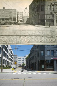
#1 We’ll start at Second and Federal Streets in 1915. The Dynamo PR Building, and another building in the left background are still around. (UC Berkeley Archives)


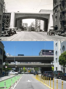
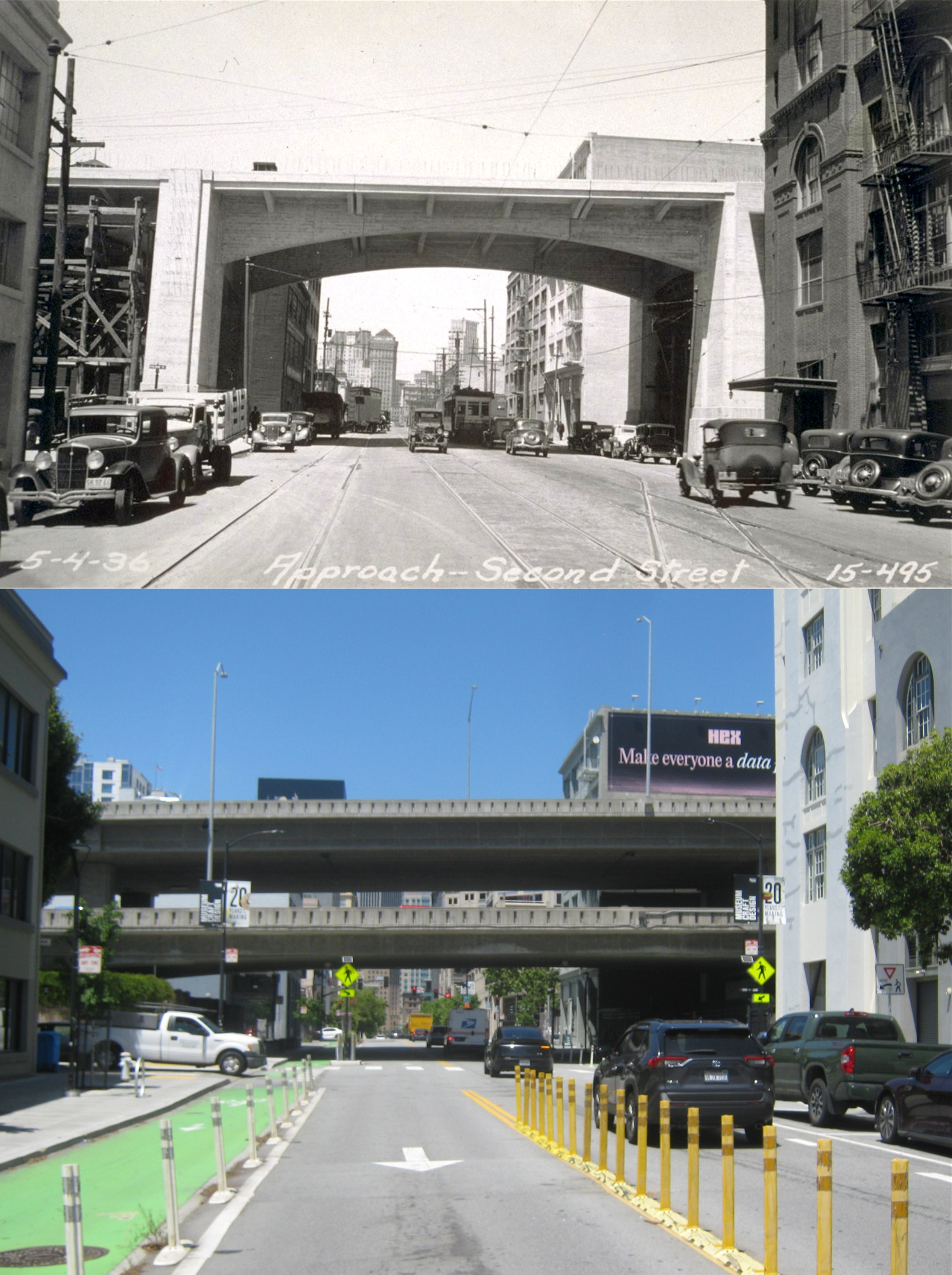
#2 Second Street, north of Bryant, in the 1930s: The approach to the Bay Bridge was under construction then. On the right in both photos, is the Clock Tower Building where Intershop Communications is now. Far in the background of the vintage picture you can see the Hobart Building on the left, and the Russ Building on the right. (UC Berkeley Archives)


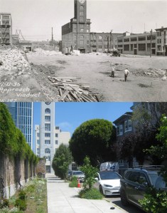
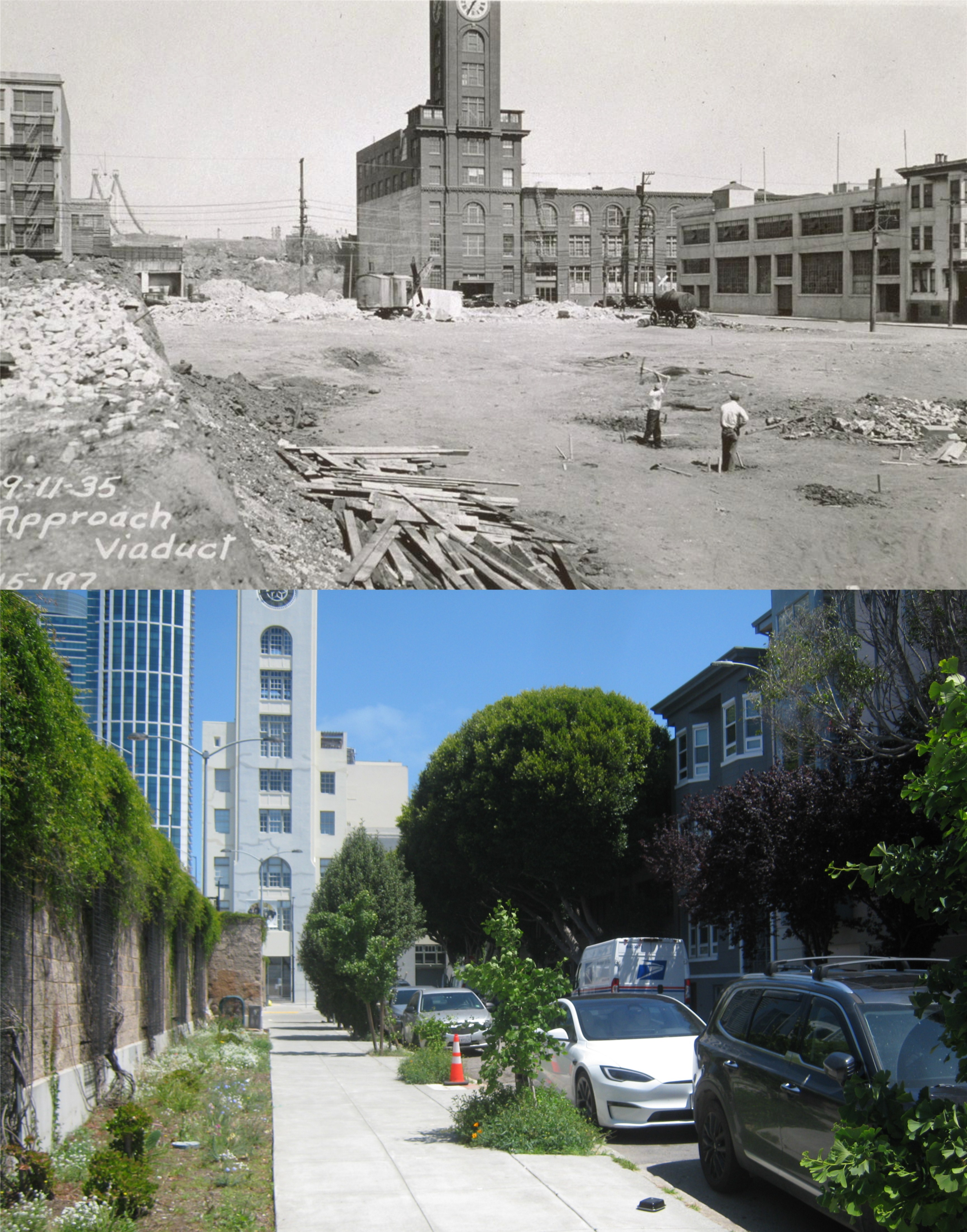
#3 Stillman Street, referred to as a Viaduct in the 1935 picture, looking east toward the Clock Tower Building. With the freeway on my left, this is as close to a comparison as I could get. The building on the right in the vintage picture is still there behind that enormous tree that my friend Tony could identify. (UC Berkeley Archives)


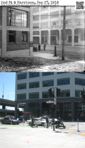
#4 Here’s a great 1918 picture from opensfhistory.org at Harrison and Second Streets. Now I’m guessing, and it’s not a bad guess, that the two buildings in the background are the same buildings. (opensfhistory.org)


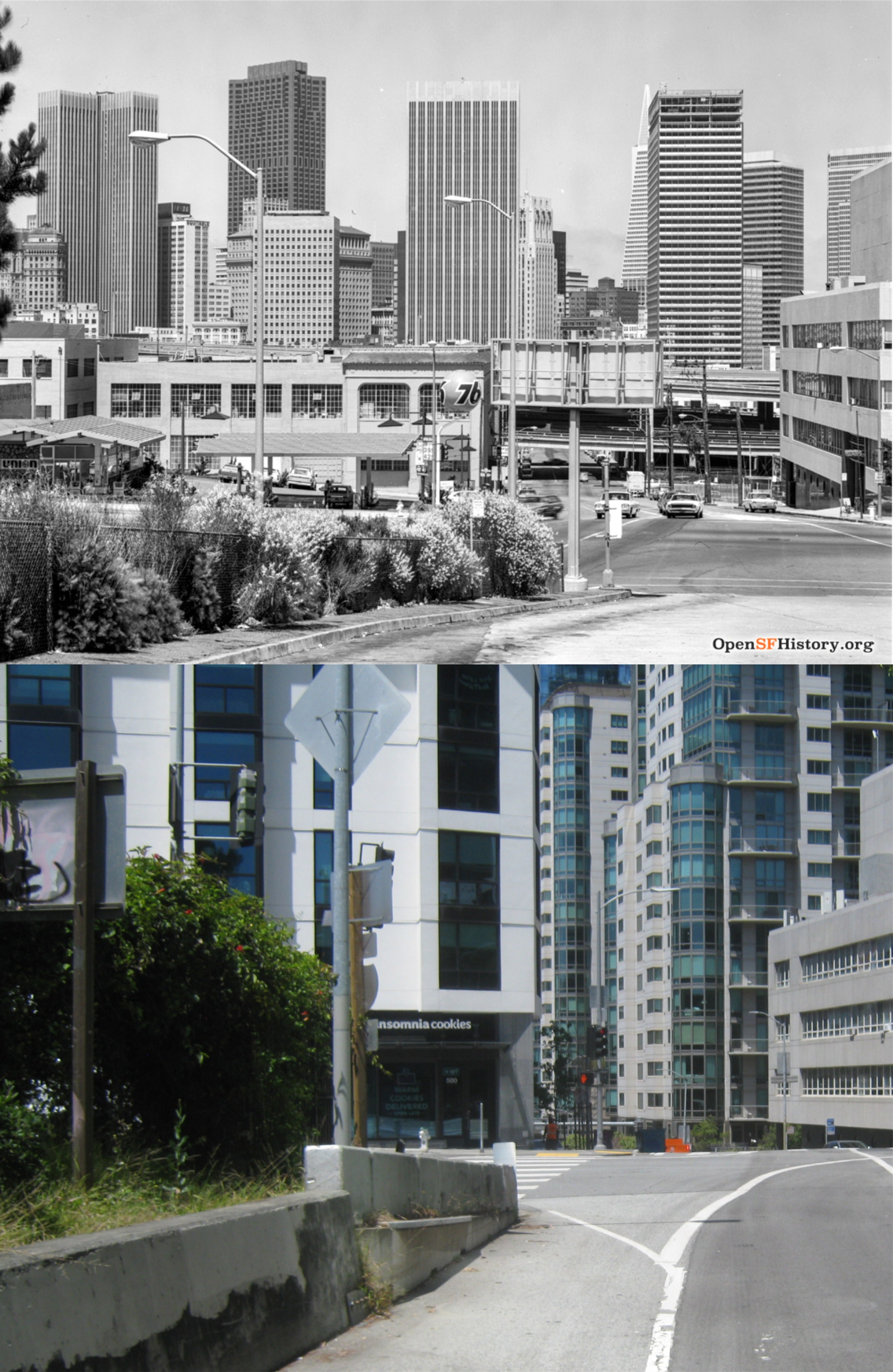
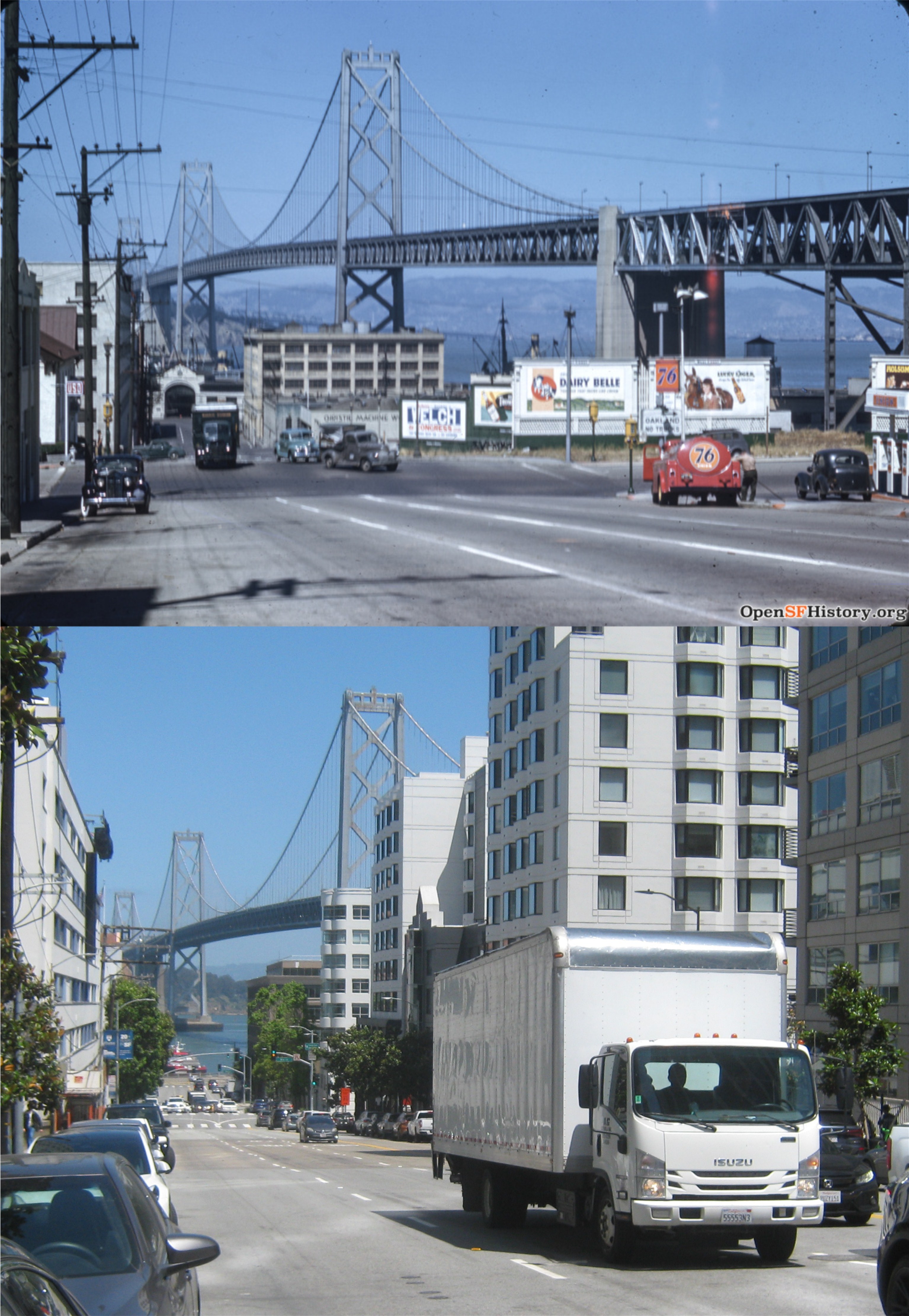
#5 I’m not showing off my bravado, but this is not a safe place to take pictures; cars turn on to the Bay Bridge approach fast, and they don’t always pay attention to the edge of the road line. The 1973 view from First and Harrison Streets, looking north, is completely gone now, but I remember it, and I remember that “last stand” gas station that survived for years after this photo. (opensfhistory.org)


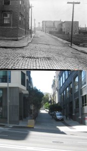
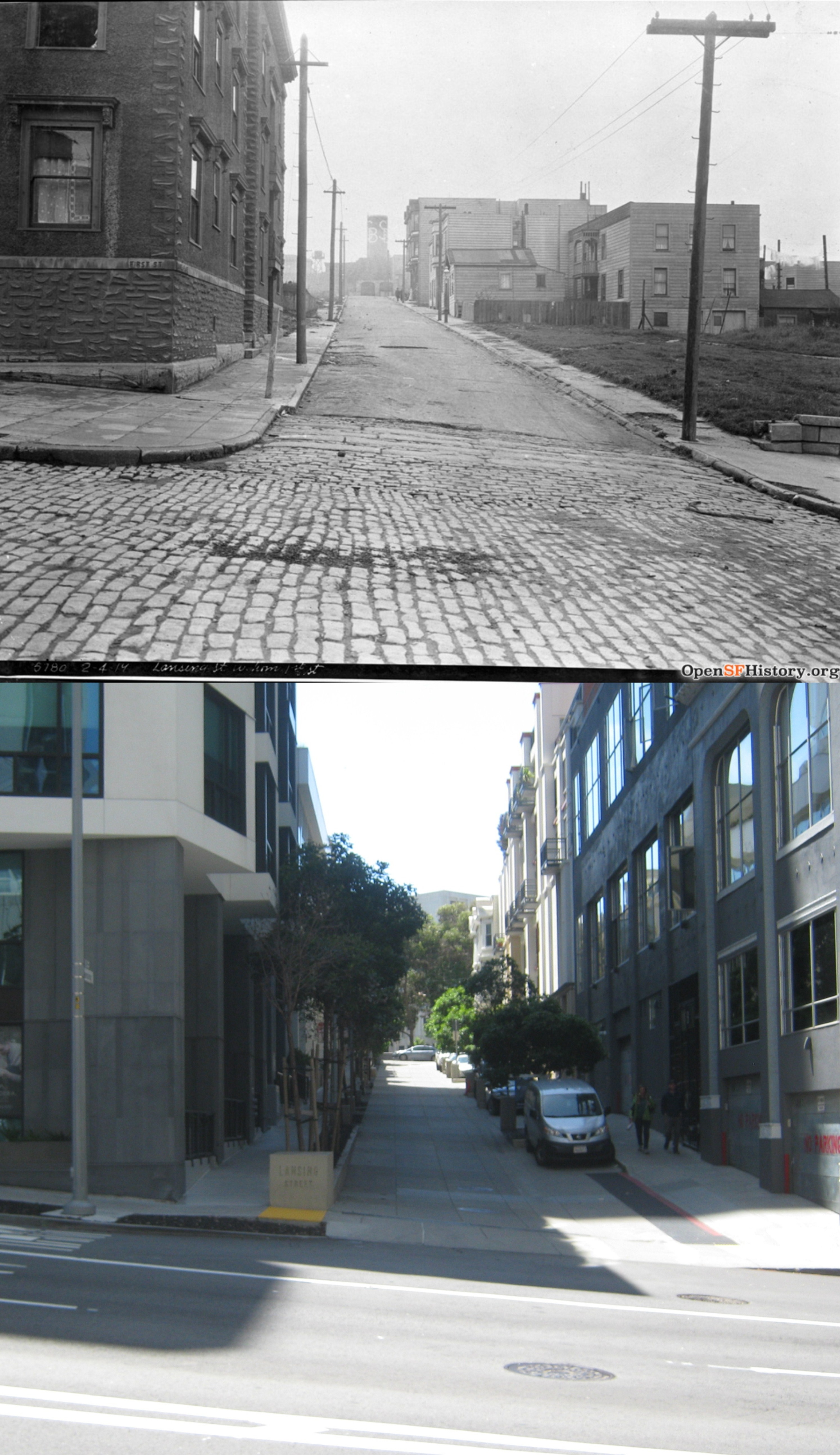
#6 Lansing Street, off of First: Now, there’s a street that you don’t think much about, although it was featured in the 1964 film ‘Good Neighbor Sam”. The vintage picture is from 1919. (opensfhistory.org)


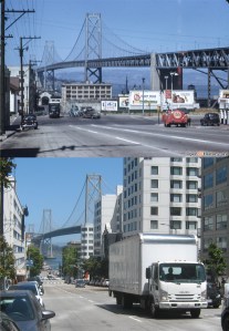
#7 Harrison Street, looking east from Fremont Street in 1945: The fact that you can still see the Bay Bridge from here is nothing short of a miracle, but the view probably won’t last for long. (opensfhistory.org)


And that takes care of that

Here’s a set of comparison pictures of Alioto’s Restaurant I’ve posted in the past that I updated to triplicate, yesterday. This collection doesn’t have a happy ending; that’s right, Alioto’s is gone. It seemed lonely and depressing walking around there yesterday; nothing felt more “San Francisco” than lunch or dinner upstairs in Alioto’s overlooking the Boat Lagoon. (Thumbnail images)

A 1950’s picture of Alioto’s and #9 Fishermen’s Grotto from the Embarcadero and Taylor Street: (foundsf.org)


Taylor Street, looking toward Pier 45 in the 1950s or early 1960s: I’ve lost the source of the vintage picture from the set I posted in August of 2015

.  

Alioto’s in a cartoon from Miroslav Sasek’s 1962 book ‘This is San Francisco’:


A 1940 picture of the Boat Lagoon from the Charles Cushman Collection, looking east. Well, at least you can see Boudin’s from here now.


Steve Keller (Michael Douglas) and a call girl he’s protecting from one of her “clients” who’s trying to kill her, walk past the Boat Lagoon in a ‘The Streets of San Francisco’ episode titled ‘The First Day of Forever’:

The Cliff House, then and now, and NOW

I took another visit out to the Cliff House today, first time since January of 2025. That was an overcast day too, but the pictures I took today aren’t as dismal as they look; a fence around the Cliff House means renovations, and renovations means a positive step toward the Cliff House reopening. The January before last there was talk of a possible Cliff House reopening by December of 2025, now there’s talk that the famous restaurant may be open by the end of 2026; not likely. However, the positive news is that it’s going to be back in business, and it’s still going to be called the Cliff House. I gathered some then and nows I’ve posted on the Cliff House in the past and, updated them to triplicates. The forecast for the landmark is not as gloomy as today’s weather. (Thumbnail images)


A 1950’s picture of the Cliff House that I posted in June of 2015: (ebay.com)


Another 1950s shot of the Cliff House from a trail that I found in 2017 that wraps around the edge of Sutro Heights. I’ve lost the original source of the vintage picture.


The north side of the Cliff House during the 1960s in a comparison picture that I took in June of 2016: (vintagevacationpictures.com)


This 1940s update is always worth the risk of running across Point Lobos Avenue for. (cliffhouseproject.com)


Parking on the south side, which was a challenge during the 1950s and in May of 2018, isn’t a problem right now. (Virginiapicks)