Well, we’re a week away from the summer solstice. Spring, and the things that I look forward to each year; the end of Tax Season, baseball games, Disneyland, the Rowell Ranch Rodeo Chili Cook-Off, and the opening of the Alameda County Fair were just a few of spring traditions I like that were closed or cancelled starting on March 17th. Even St. Patrick’s Day, which really isn’t in spring but to me represents the arrival of spring, was quiet and depressing. On February 29th 2020 I was invited to the 40th annual meeting of the Institute for Historical Study at the Dimond Branch Library in Oakland. I had recently been approved for membership in the society, and I was proud to be there. They had a number of upcoming events I was looking forward to enjoying, which, of course, have been postponed right now. I don’t think anyone in that room anticipated what was coming or how the world would change in just a few weeks, and spring would slip away a bad memory. These are a collection of pictures I posted during spring seasons of happier years. Many people are suffering heartbreak to due to COVID-19 at this time, so I don’t want this post to seem like a complaint; it’s just reminiscence.
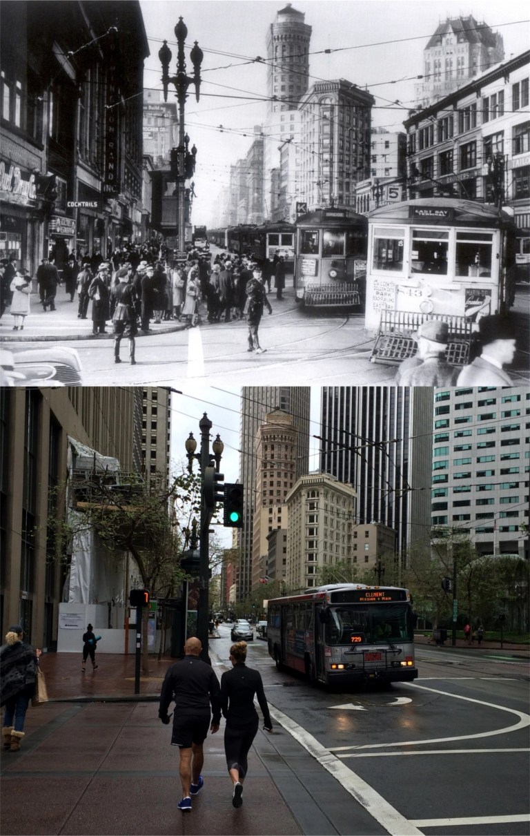 March 21st 2016, the first full day of spring: San Francisco gets lots of rain in the spring. The vintage picture at 1st and Market Streets was taken during the 1930s. (San Francisco Main Library History Room)
 March 21st 2016: The vintage picture from the Shorpy Archives was taken at the old El Capitan Theater on Mission Street between 19th and 20th Streets.
 April 2nd 2017: The restored Dutch Windmill on the northwest corner of Golden Gate Park.
 April 23rd 2016: Ocean Beach and the old gingerbread Cliff House, destroyed in a fire in 1907. (The Cliff House Project website)
 April 27th 2016: Kids “nipping the fender” on a streetcar at South Van Ness and 26th Street, (mislabeled in the vintage picture as being at 26th and Army Street) in 1943. (Charles Smallwood)
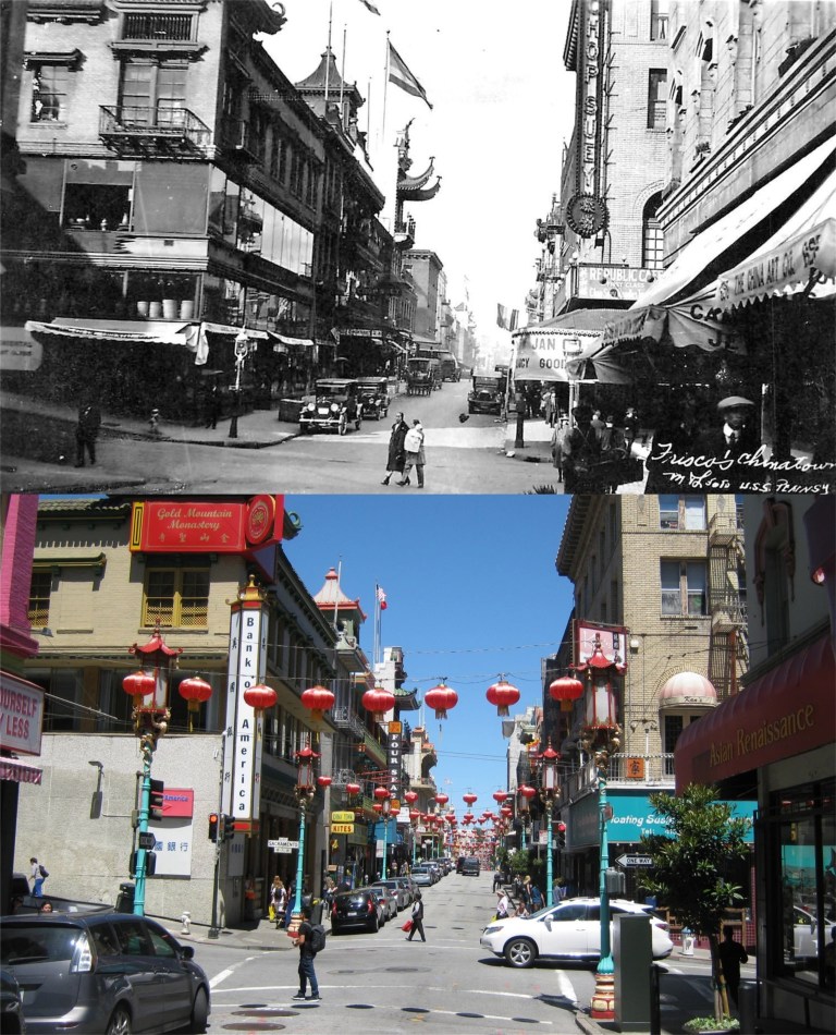 May 2nd 2017: Grant Avenue and Sacramento Street in Chinatown in the 1930s.
 May 6th 2015: Lotta’s Fountain at Kearny and Market Streets in a wonderful vintage photo from the early 1900s.
 May 13th 2018: The view from Corona Heights in a comparison picture I took on Mother’s Day in May of 2018, back when the word corona wasn’t so scary. The vintage picture was taken in the 1960s. Mother’s Day was another spring tradition lost during the COVID-19 Pandemic of 2020. (Michael Bry)
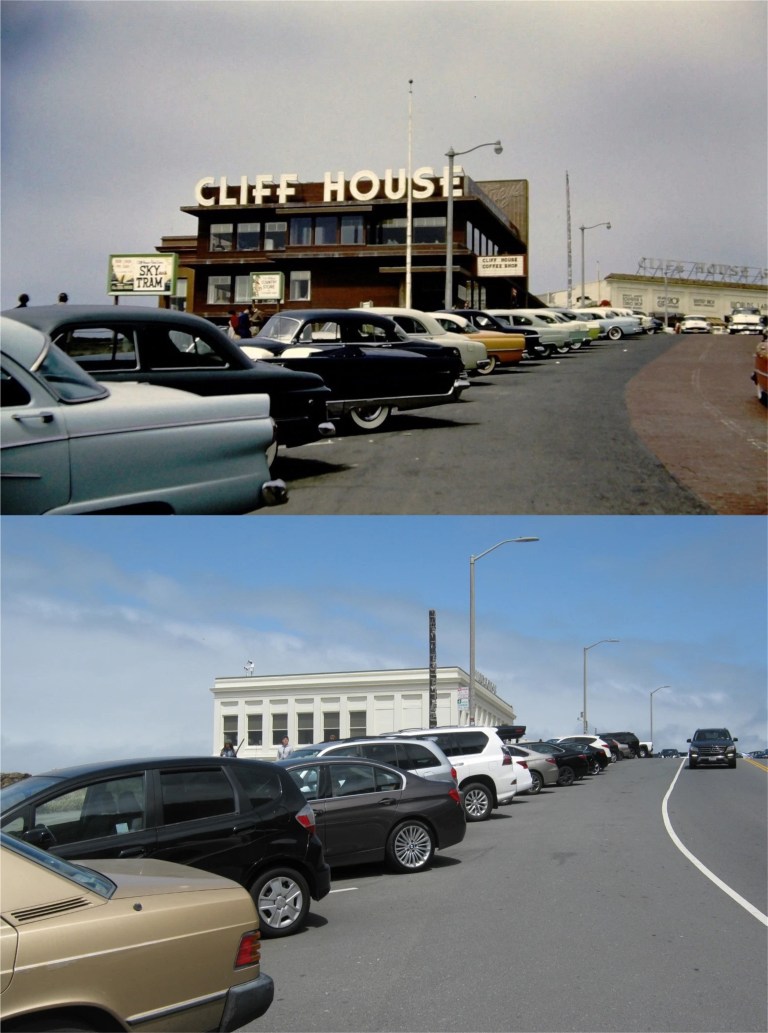 May 13th 2018, the Cliff House in the 1950’s: I sure will be glad when that opens up again. (virginiapicks)
 May 18th 2016: Sleeping Beauty Castle on Disneyland’s opening day, July 17th 1955. I can hardly wait to get back there as well. I don’t think crowds will bother me as much anymore after the lonely emptiness right now at places I enjoy going to, like Disneyland.
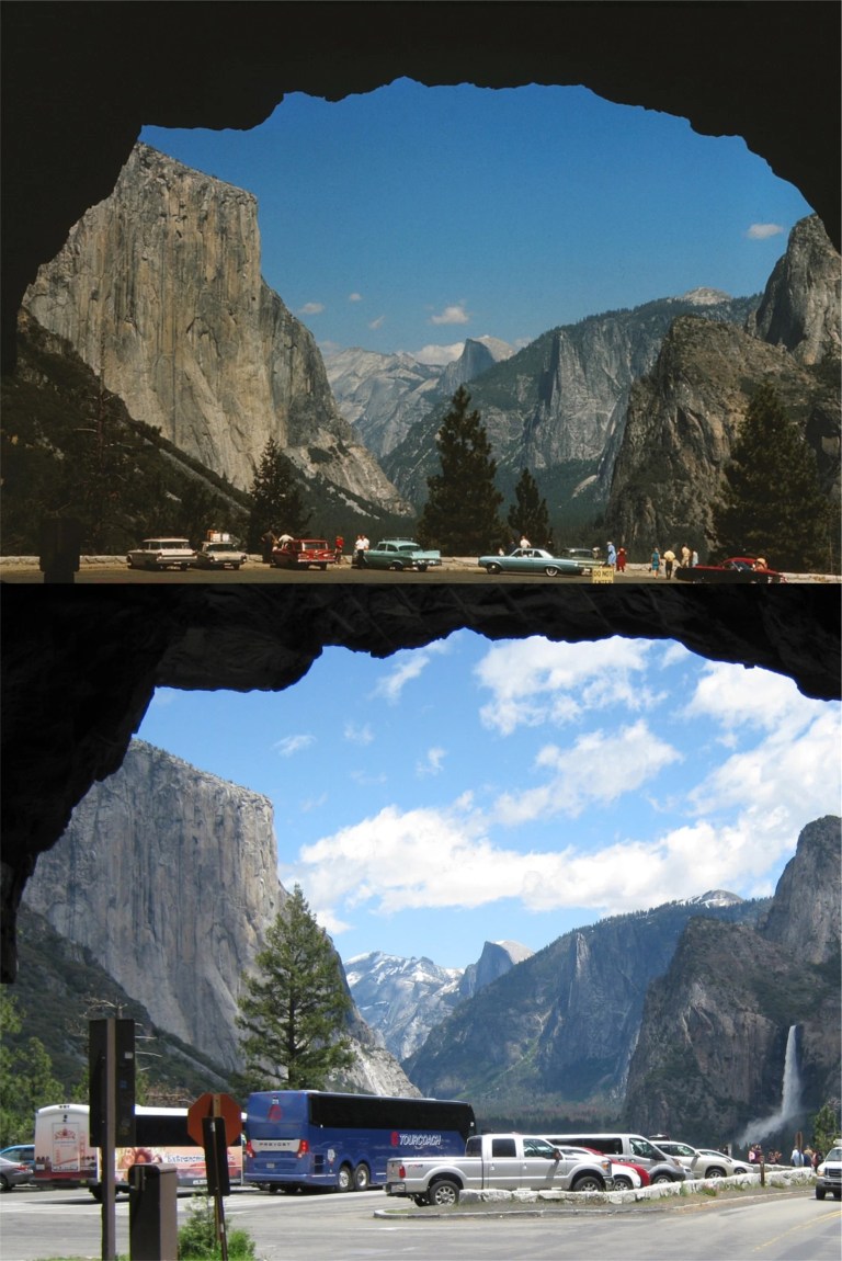 May 23rd 2017, Yosemite National Park: May and October are my two favorite times to visit Yosemite. In May the waterfalls are spectacular due to the runoff of the melting snows from the mountains. October is the best month to catch the fall colors of Yosemite before it gets too cold. I missed the park in May of this year, but I’m keeping my fingers crossed for October.
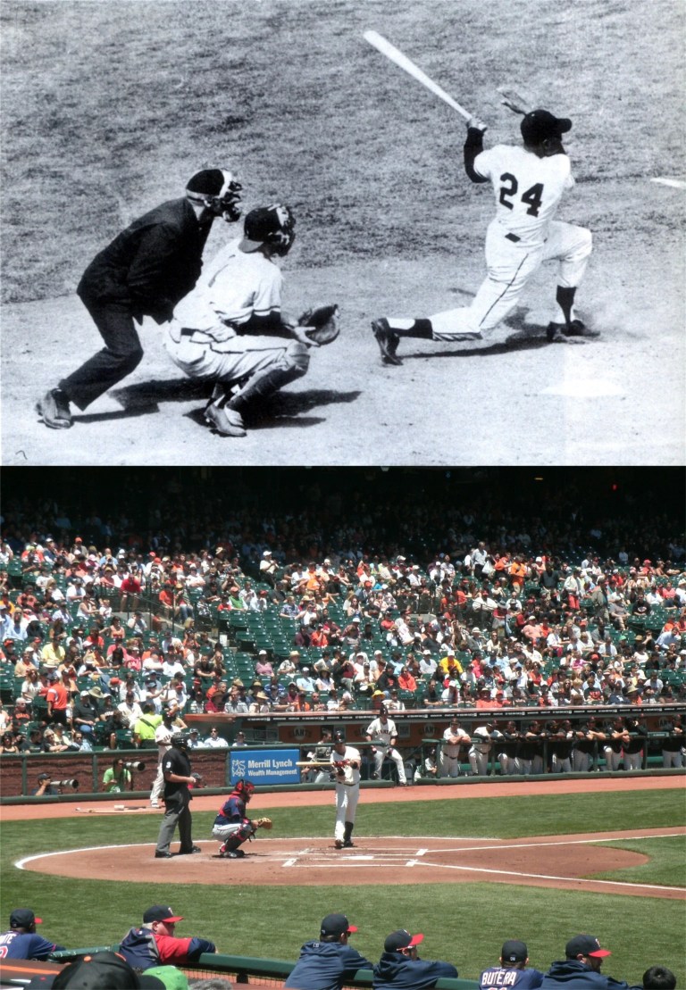 May 30th 2016, at what was then called AT&T Park: To paraphrase Jack Nicholson as McMurphy in the 1975 movie ‘One Flew Over the Cuckoo’s Nest’, “Somebody give me a hotdog (at the ballpark) before I die!” The vintage picture is of Willie Mays knocking one out of Candlestick Park during the 1960’s. (Barnaby Conrad and Bay Area Photographers Society)
 May 30th 2016: Ah, the Jeremiah O’Brien moored at Pier 45; she’s not there anymore. The pier to the right of where the Liberty Ship was docked at was destroyed in a huge fire, and the ship has moved over to Pier 35 for the time being. The top photo is a Philippine cargo shop on the waterfront in the 1950s. (Phil Palmer)
 June 1st 2017: The Tea House at the Japanese Tea Garden in Golden Gate Park. The vintage picture from the 1940s was when the name of the garden was changed to the Oriental Tea Garden after Pearl Harbor until 1952. The name Oriental Tea Garden would cause a reverse offense from many Asian people nowadays.
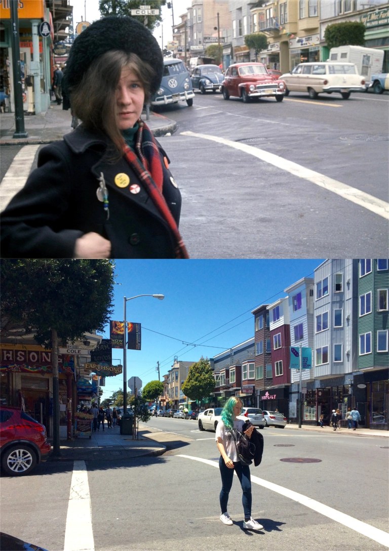 June 9th 2016: Janis Joplin on the corner of Cole and Haight Streets in 1967. (buzzfeed.com)
 June 14th 2016: The cable car turnaround at Powell and Market Streets, seen in a vintage picture from the late 1930s. And wouldn’t it be nice to go for a ride on a cable car again someday.
 June 18th 2016: I’ll end my spring look back at the Alameda County Fair in Pleasanton, another cancellation in 2020 due to the pandemic. I might be able to go to Disneyland someday in the near future, but for this annual tradition I‘ll have to wait for another year.
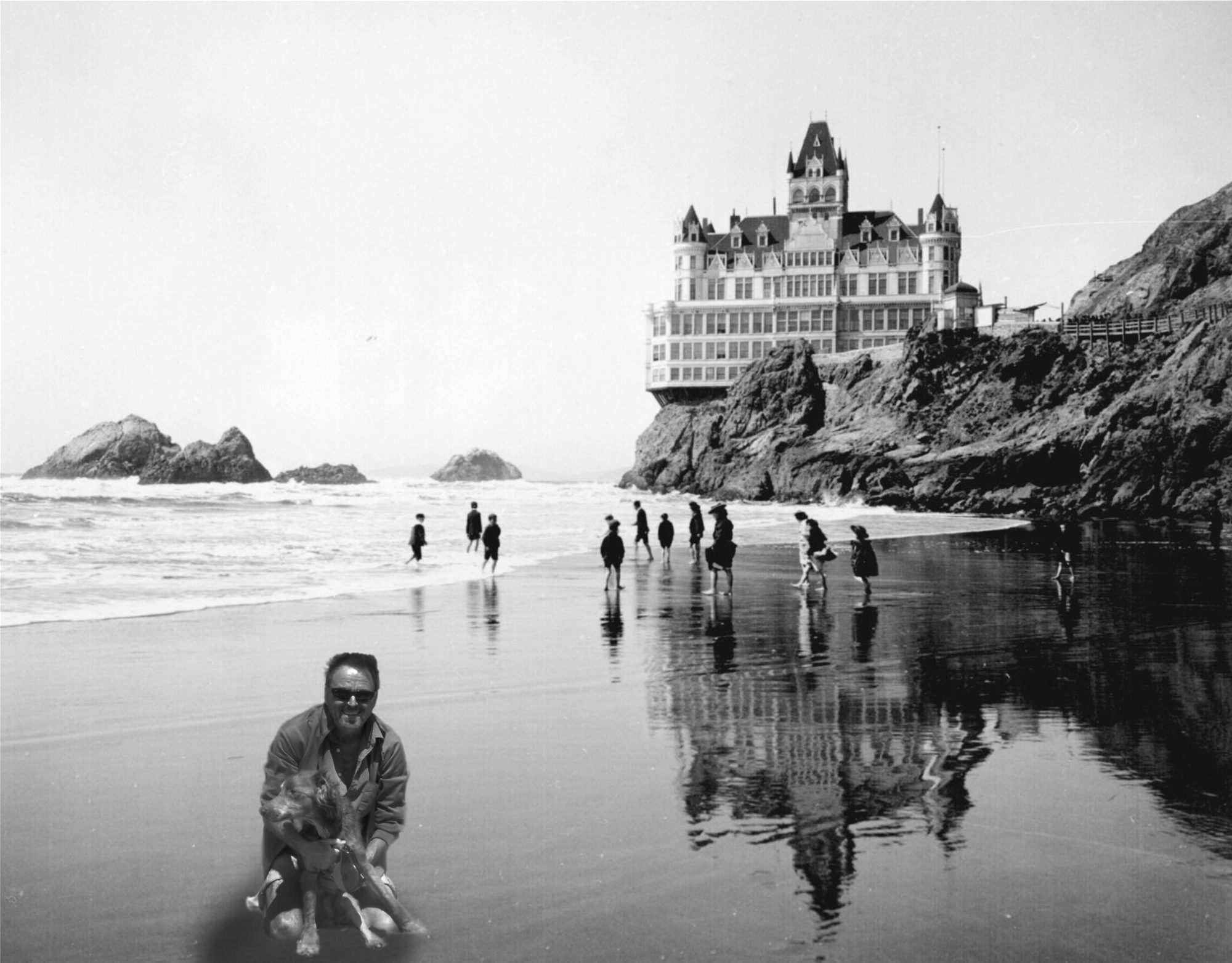

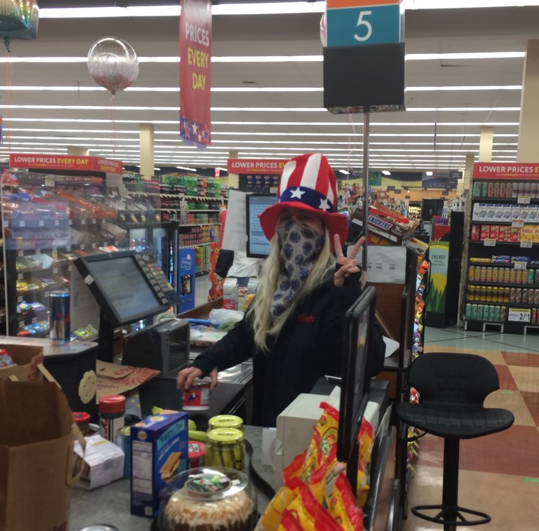 Although I enjoyed the stretch, a Tax Day in July seems unpatriotic, (my take on a freepik.com cartoon) and pretty girls looking a combination of Uncle Sam and Jesse James made for an unusual 4th of July. Anyway, tax season ended this week and I did what I usually do after the deadline to file tax returns, I went over to San Francisco to take pictures.
 I approached the San Francisco City & County Limit the way I often do, on the eastern span of the Bay Bridge. The vintage picture was taken on the opening day of the bridge, November 12th 1936. Treasure Island was still under construction then. This whole portion of the bridge was replaced in 2013.
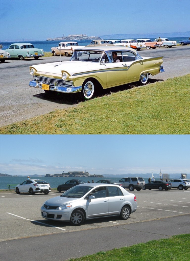 Stopped for lunch on the Marina Green, seen in the 1950s in a cool looking vintage picture from the San Francisco Remembered Facebook page: (Lily Castello)
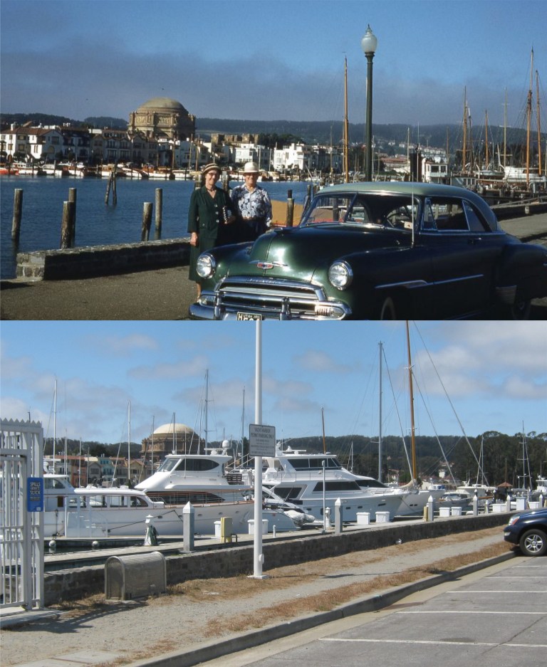 Looking across the Marina Yacht Harbor toward the Palace of Fine Arts during the 1950s; yachts have gotten bigger since then. See if you can spot which one is mine. “Knock it off, Tim!” (Vintage Everyday)
 Looking through the arch of Pier 43 toward Pier 45 where the Liberty Ship the Jeremiah O’Brien was docked before the disastrous fire at the pier last May forced the ship to relocate. I’m really unhappy about that. You can see the fire damage to the pier.
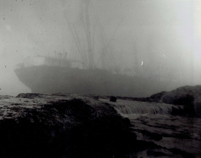 Speaking of ships, this has to be one of the spookiest San Francisco pictures I’ve seen. That’s the SS Ohioan, shipwrecked and stranded on the rocks behind the old Sutro Bathhouse in 1936. In December of the following year, what was left of the ship broke in two and sank into the Pacific Ocean. (ebay.com)
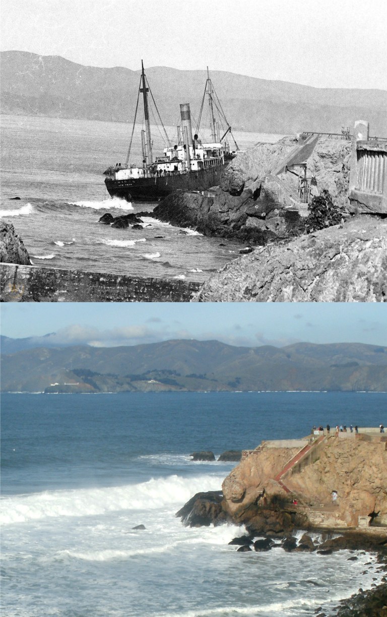 A vintage picture from worthpoint.com shows the stranded ship being pounded into the rocks by the surf. Salvage efforts continued on the ship for over a year before she sank.
 Looking toward Ghirardelli Square during the 1960s: The Ghirardelli letters on the roof were taken down recently for restoration. Just as I was getting ready to snap the picture, a MUNI bus pulled up and the driver got out. Oh, well, we have to rise above. (ebay.com)
 The Columbus Statue at Coit Tower during the 1960s: The statue was taken down and put in storage earlier in June. (ebay.com)
 Mason Street, between California and Pine Streets: If you’ve ever wondered what it’s like to drive while wearing 3D glasses, the vintage photo from the 1950s will give you an idea. (ebay.com)
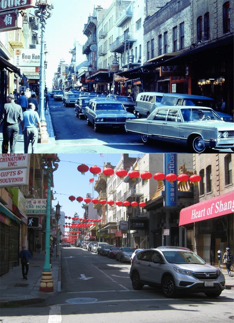 Grant Avenue at Washington Street in 1973: They’re slowly starting to trickle back into Chinatown as well, and a few of the gift shops are starting to reopen too. (worthpoint.com)
 This building used to be the Telephone Exchange Building where a lot of the to and from long distance calls in San Francisco were directed by operators receiving them. It was considered so important that after Pearl Harbor it was sandbagged to minimize damage in the event of the Japanese bombing San Francisco. Those would be great against vandals today, but they have some other kind of metal temporary doors and windows guarding the building now.
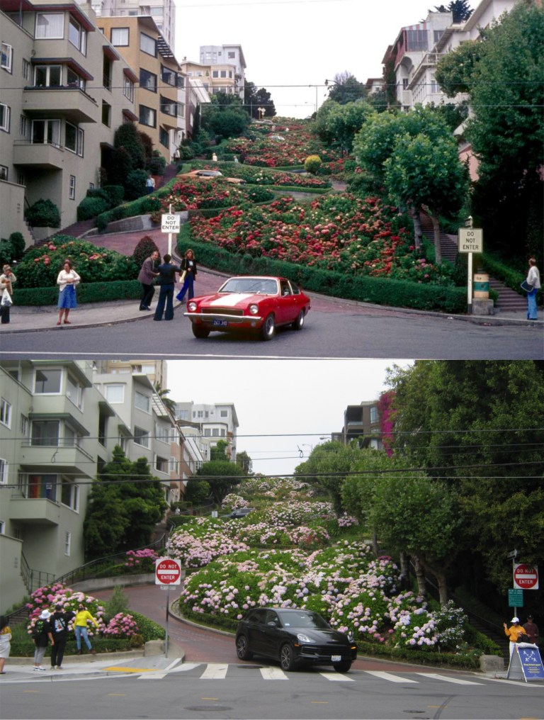 Tourists are starting to come back to Lombard Street slowly, as well. They’re getting close to the level of the vintage picture taken in 1975. After I took my picture, I walked past four girls grouping together for a selfie. I gave them a thumbs up and said, “A masterpiece!” and they giggled. It made me feel good, like the old days in San Francisco. You Know, like four months ago. (The Houston Chronicle)
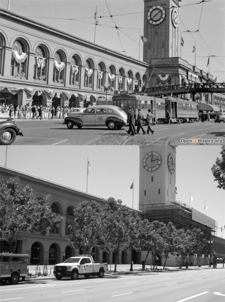 The bunting on the Ferry Building in the opensfhistory.org picture fits right in with the 4th of July coming up this weekend, but it was actually taken February 18th 1939 celebrating the opening day of the Golden Gate International Exposition on Treasure Island.
 Geary St. at Kearny, near Market during the 1950’s: The entrance to the old Chronicle Building is on the right in both photos. I can take a straighter picture than the vintage picture, but not nearly as interesting of a one. Hmm, ‘COLONICS-X-RAY’, I wonder if chiropractic doctors still offer that service anymore. (worthpoint.com)
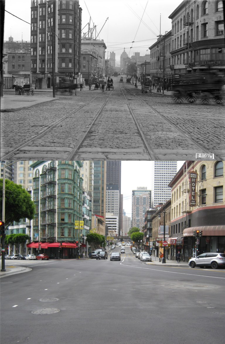 I’ve wanted to do this one for awhile; Kearny Street at Columbus Avenue, (at least for now) in 1910. That’s the Sentinel Building, owned by Francis Ford Coppola, on the left in both pictures. (San Francisco Pictures Blog)
 Russian Hill from Telegraph Hill in the 1800s: They’ve put up a few more shacks around here since then. You can just see the towers of the Golden Gate Bridge through the fog in my picture.
 Looking east from 5th Street toward the Flood Building: The Emporium sign on the building on the right now has Bloomingdale’s painted on it. The domed Humboldt Building, built in 1908, is in the background of both images.
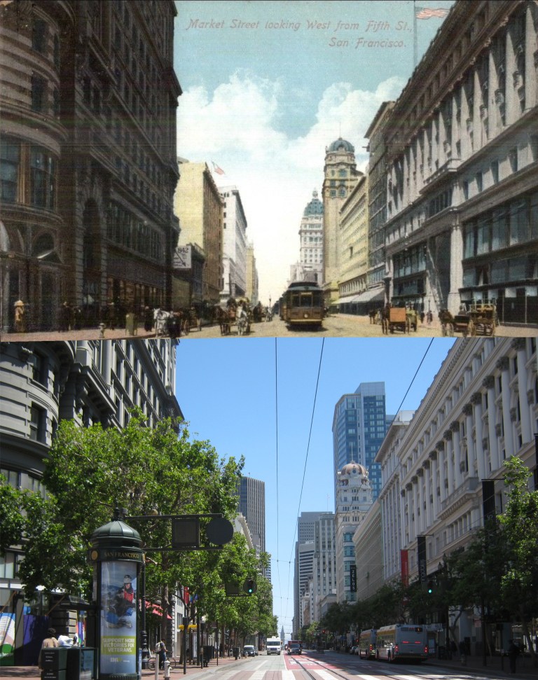 I’m closer now to the Flood Building and the old Emporium Building on the right. The crowned Call Building, remodeled and now called Central Tower, can be seen behind the Humboldt Building.
 I’m in front of the Emporium Building now. If it wasn’t for the shade, I’d have been a lot happier with this picture. Many of the old buildings, like the West Bank Building, the Phelan Building and the Gothic looking Mutual Savings Bank Building, are still there.
 4th Street and closer to the Humboldt Building seen in a postcard from 1915:
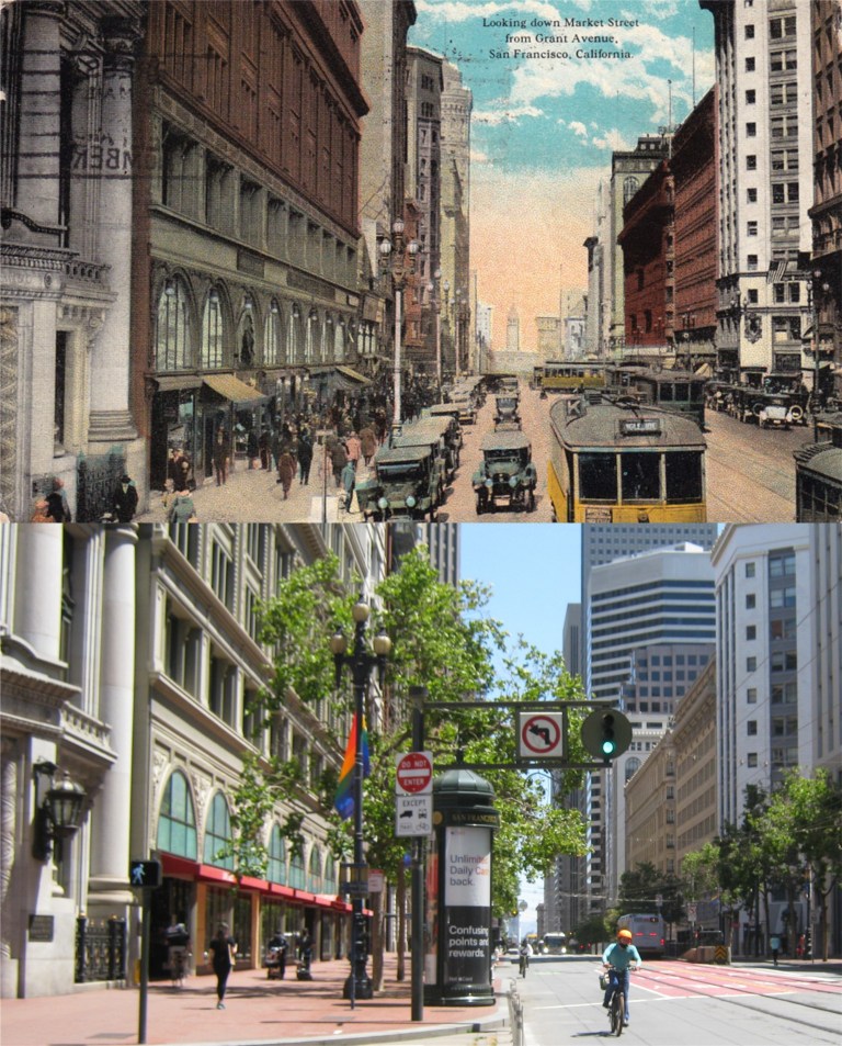 Market Street at Grant Avenue: This one has the postmark on it. Four Buildings still seen on the right from the same period as the postcard are the Hearst Building, the Monadnock Building, the Palace Hotel, and the Metropolis Trust and Savings Bank Building. I’m standing near the old pillared Union Trust Building.
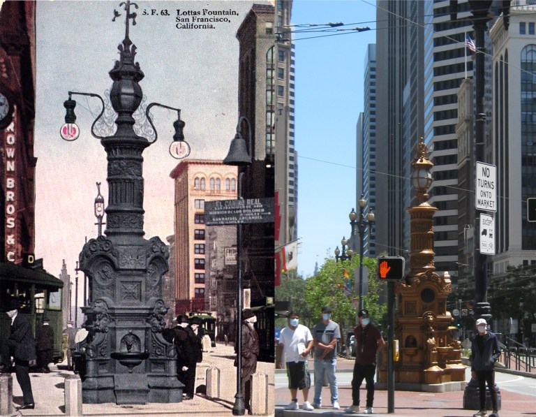 Lotta’s Fountain at Kearny and Market Streets; at a little different angle now, but in the same spot where it was originally placed in 1875:
 The Palace Hotel, rebuilt in 1909 after the original grand hotel, built in 1875 and visited by the likes of Ulysses S. Grant and Enrico Caruso, who was staying at the hotel when the 1906 earthquake struck, was destroyed during that disaster.
 I ended up at the Ferry Building, looking past where the old pedestrian footbridge was toward the Southern Pacific Building. The crowd of demonstrators in my picture were gathering to commemorate Juneteenth Day, the annually recognized day of the end of the slavery of African Americans in the Confederate States. They took over Market Street for awhile too, but they didn’t cause any trouble or hurt anybody.
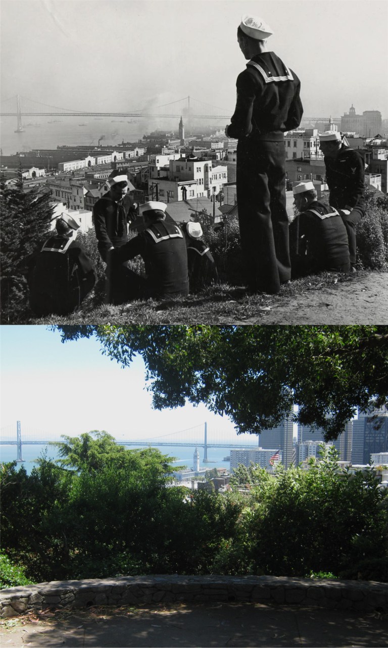 Sailors enjoying the view from Pioneer Park behind Coit Tower, either in the late 1930s or during World War Two; I couldn’t get a date on this fine picture. (mutualart.com)
 I’m assuming the artist Luigi Kasimir wouldn’t have drawn this terrific sketch looking northwest from the steps of Coit Tower in the 1930s if the portable bathroom and concession stand were there then, the trees blocked the view like today, and the balustrade wasn’t there. You can barely see the Marin County hills through the trees and glare in my picture. (henningfineart.com)
 1360 Montgomery Street, the most famous apartment building on Telegraph Hill: It was here that Humphrey Bogart hid out with Lauren Bacall in the 1947 film ‘Dark Passage’. (twitter.com, posted by Cory Doctorow)
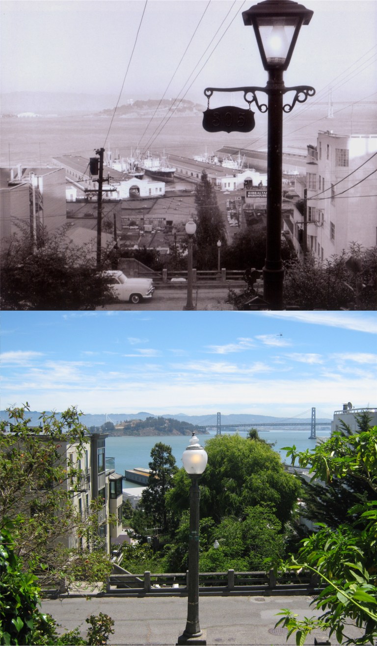 Looking down the Filbert Steps toward Montgomery Street in 1959: You have to get a little closer to the street to see the view from here today. I picked up a dragonfly at the top of my picture. (Gene Wright)
 Looking toward Ocean Beach and the Great Highway from the Cliff House in the early 1900s: With some shelter-in-place restrictions lifted slightly at the beginning of June, parking is allowed again at Ocean Beach. You can see the Dutch and Murphy Windmills in Golden Gate Park in the upper right. (Pinterest)
 The Great Highway from Sutro Heights with Chutes-at-the-Beach in the 1920s: (eBay posted on pinterest)
 The fire that destroyed the old gingerbread Cliff House in 1907, seen from Sutro Heights: (gendisasters.com)
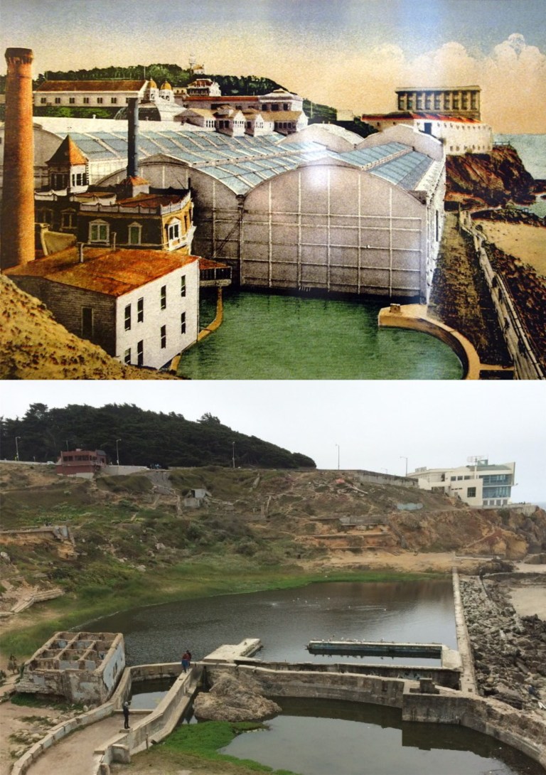 This picture I took a few years back of the Sutro Bathhouse ruins lines up pretty good with the old drawing of what it looked like. The concrete squared ruin in the lower left of my picture was where the pump house, seen with the tall chimney in the vintage drawing, was located. (eventbrite.com)
 The misnamed Seal Rocks from the Cliff House: There were never seals on Seal Rocks, they were sea lions, and they’re gone now. (seeninsanfrancisco.com)
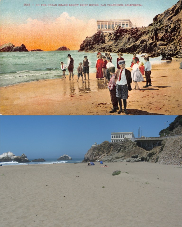 A group of people on Ocean Beach, probably around 1910: That’s the present day Cliff House built after 1907, and people stopped dressing like that by World War One. I don’t like the looks of that little toughie in the front of the crowd.
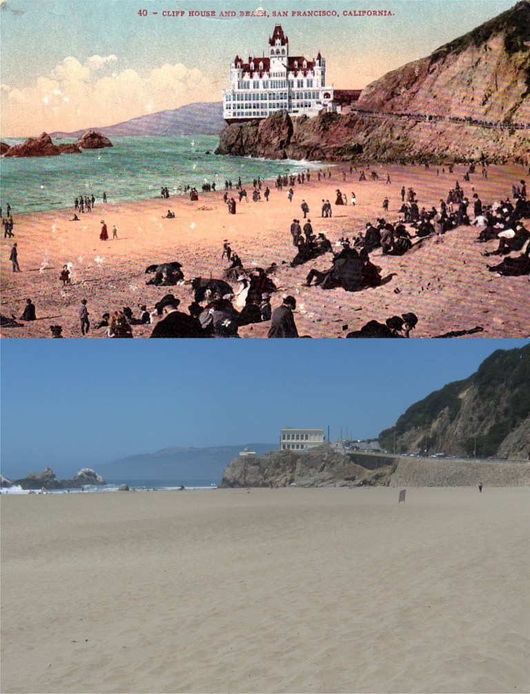 Ocean Beach, Seal Rocks, the Cliff House, and Sutro Heights in the early 1900s: (sanfranciscodays.com)
 This one looked perfect, at first; the gap between the Dewey Monument and The St. Francis Hotel on the left matches up, as does the gap between the monument and the Chancellor Hotel to its right in the picture. The St. Francis Hotel in my photo lines up nicely with the vintage picture, and the angle of the two crosswalks in the photos line up close, although they’re probably not painted today exactly where they were in 1953. However, on a closer look, the Dewey Monument is a little higher up in the vintage picture. Maybe a few steps farther forward might have done it. The 1953 picture from the Charles Cushman Collection was taken at the southeast corner of Geary St. and Stockton Street looking toward Union Square.
 Heading up to Nob Hill, I thought my quest was going to be short and sweet. When I put them together, this 1961 photo looking toward the Pacific Union Club on California looked perfect, until I got to the roof; the remaining cornice on the roof balustrade is out of line with the building in the background in the my picture. (San Francisco Pictures Blog / blogspot.com)
 Walking down Powell approaching Pine Street, I got another one pretty close. The cable car tracks aren’t laid out exactly where they were in the 1970s picture posted on Pinterest, so my picture wouldn’t line up very well standing directly between the tracks, as in the vintage picture. Also, I needed to be closer so it doesn’t count.
 This 1967 picture is looking back up Nob Hill from Pine and California Streets toward the Fairmont Hotel. I’m close here too. However, if those are the same manhole covers in both pictures, I’m a little off. That’s what people usually say about me anyway. (San Francisco Pictures Blog / blogspot.com)
 I’m back downtown and looking west on Ellis Street from Stockton. Notice the John’s Grill Restaurant in the two photos. Both pictures were taken on the corner of 4th and Markets Streets. The Crocker Anglo Building, remodeled, is still there but the building between it and John’s Grill has been replaced. The angle and width of the Crocker Anglo Building are good and it lines up with the windows on the Flood Building on the background, but the two buildings and John’s Grill in my picture aren’t directly beneath the three buildings in vintage picture. Conclusion, I’m not standing quite in the same spot as the photographer in vintage photo. Duh! (Opensfhistory.org and outsidelands.org)
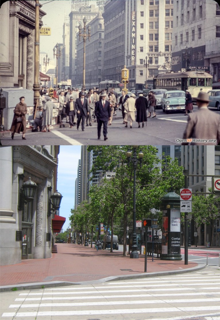 Wandering down Market Street to Grant Avenue in the mid 1950: I liked my chances with this one, but it didn’t work out. I tried to get the old Hearst Examiner Building on the right to line up close with the even older Call Building across 3rd Street, but it looks like I was too far back. You can’t see the Palace Hotel in the background from here today through the trees, so I’m safe there. However, back across Market Street where the old Wells Fargo Building on Grant Avenue is, well, like Eli Wallach said to “The Man” in the 1958 film ‘The Lineup’ “that’s where the job went to pieces.” I’m too close! Yet when I moved farther back to get a good angle on the old bank building, the previous mentioned buildings across Market Street were way out of sync. Oh, well.
 I’ll end my journey here because I don’t think I’ll ever get a perfect line up, but this one matches up about the closest. The old blurry picture was taken on the southwest corner of Powell and Sutter Streets in 1949. The Sears Food Restaurant has moved one block behind me between Sutter and Post Streets. (San Francisco Pictures Blog / blogspot.com)
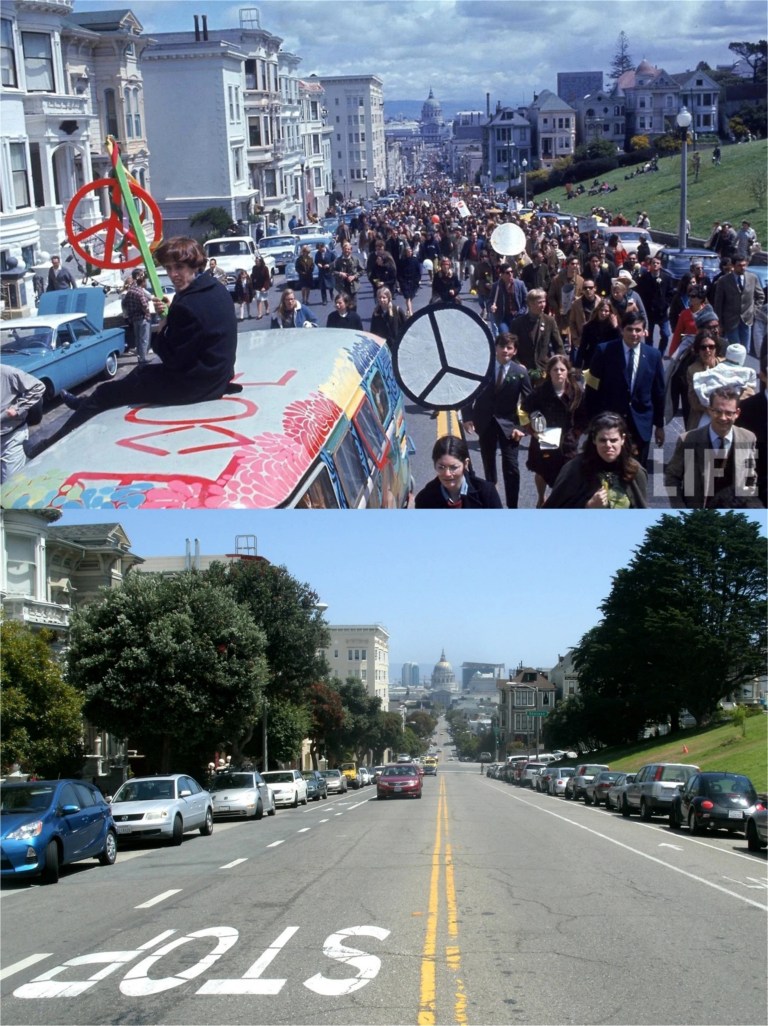 A peace, love, and end the Vietnam War rally passes Alamo Square along Fulton Street in 1967. Demonstrations like this helped to make that war unpopular and may have contributed to its ending, although there were some disasters along the way, such as Kent State, Ohio.
 World War Two wasn’t unpopular in the United States, although, it wasn’t all that welcome, either. Servicemen and women packed San Francisco on their way to, and coming from the battlefronts, as seen in this 1943 photo from LIFE Magazine taken at Mason, Turk, and Market Streets. 71 years later, San Franciscans were united again in celebrating a parade at this spot in honor of the San Francisco Giants third World Series victory. Even rain on the parade didn’t “rain on the parade”.
 In 1937, six years before the previous picture was taken, citizens from the Chinese community in San Francisco demonstrated in front of Pier 45 at Fisherman’s Wharf. They were calling on the United States Government to stop importing products to Japan, after Japan’s invasion of China. (Vintage picture from museumca.org)
 Two years later in 1939, San Francisco invited countries from around the world to participate in the Golden Gate International Exposition on Treasure Island. A few years after the groundbreaking for the fair, the United States would be fighting against some of the countries represented in the vintage photo, such as Nazi Germany and Japan.
 Now, we’ll go back 105 years to when San Francisco celebrated the Panama Pacific Exposition of 1915. In August of 2017, I did a comparison picture of the opensfhistory.org photo taken on Market Street in front of the Ferry Building, when people from around the Bay Area gathered there to view the solar eclipse occurring that day. It never got as dark as my picture implies, I just touched it up a little bit for effect.
 Fast forward back to World War Two, (Does that make sense?) and a community war bond drive at Ocean Avenue and Junipero Serra Blvd. in the Sunset District. “We’re all in this together!” That was true then and now.
 World War Two ended in victory for the Allies and San Francisco celebrated the occasion big-time; although, these nitwits on top of a streetcar on Market Street in front of the Golden Gate Theater, dangerously close to the electrical connection, may have been carry things too far!
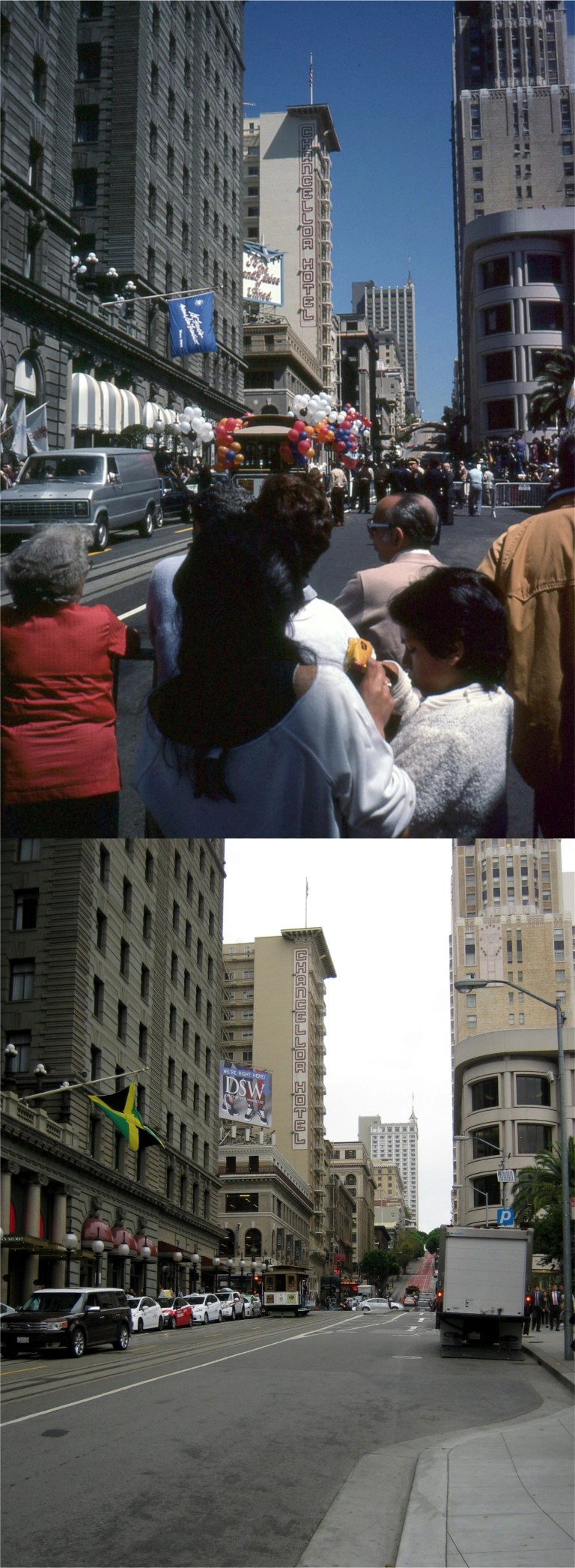 In June of 1984, San Francisco united again to celebrate the return of the cable cars after nearly two years of a shut down for repairs. The current shut down of the cable car system is the longest stretch of non operation since then. The top picture is a slide photo I took on Powell Street in front of the St. Francis Hotel.
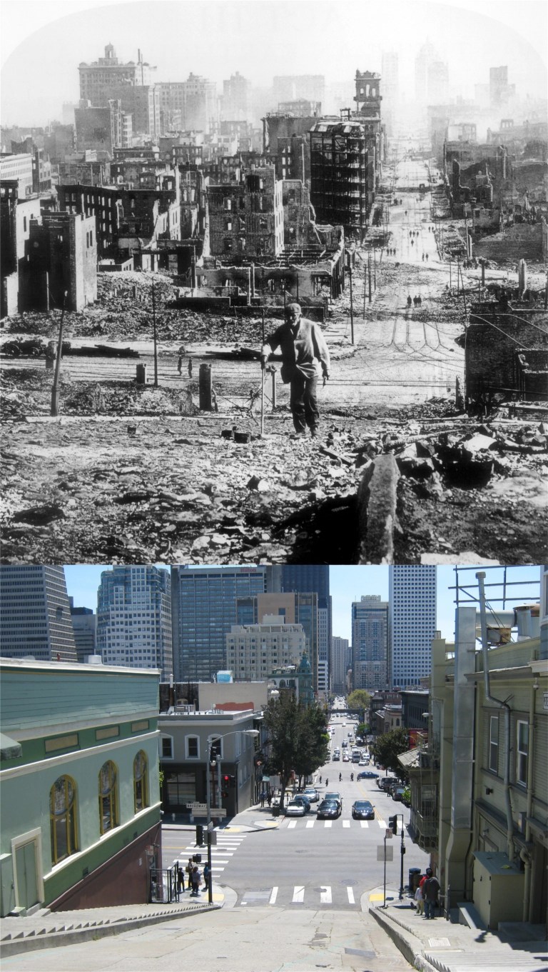 But San Francisco’s greatest collective human endeavor has to be the rebuilding of the city after the 1906 Earthquake and Fire. The vintage picture from the San Francisco History Center was taken looking down Kearny Street toward Broadway.
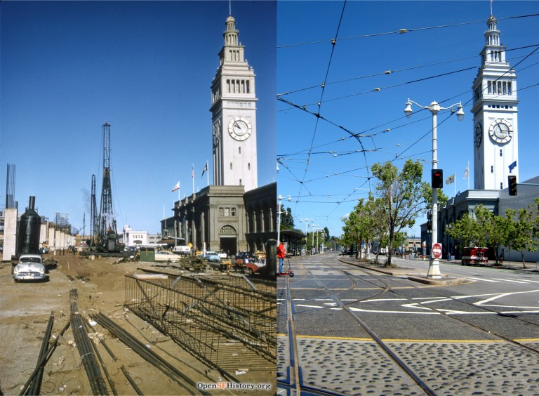 The start of construction on the Embarcadero Freeway that would eventually cut the Ferry Building off from the rest of San Francisco, seen in a November of 1957 picture from opensfhistory.org:
 The old YMCA Building on the Embarcadero near Howard Street in 1928: The building was erected in 1926. This area of San Francisco had become pretty seedy by the 1950s. Eli Wallach, “Dancer”, commits his first murder in this building in the wonderful crime movie ‘The Lineup’ from 1958. (San Francisco Picture Blog)
 The southern portion of the Embarcadero Freeway ended at Howard Street, seen here in the late 1980s. (livablecity.org)
 The northern portion of the freeway stopped at Broadway, seen here in a 1990 picture shortly before it was demolished. Construction on the freeway was originally planned to go all the way to the Golden Gate Bridge, which would have destroyed the entire Bay waterfront of San Francisco. Cooler heads prevailed and stopped that ridiculous idea, eventually. (Flickr)
 The best picture I’ve seen of the automobile underpass that allowed cars driving along the Embarcadero to cross under the streetcar turnaround at Market Street in front of the Ferry Building. This 1935 picture from opensfhistory.org was near where Clay Street entered the Embarcadero. This is a great little picture; the southern wing of the Ferry Building and one of the towers from the Bay Bridge are on the left, and I wonder what that little kiosk was for; possibly, a signal to regulate when the streetcars could proceed.
 The northern wing of the Ferry Building with the passenger footbridge on the right in 1939: The embankment at the top of the Embarcadero underpass is behind the cable car that ran along the Sacramento Street line from the Ferry Building. (opensfhistory.org)
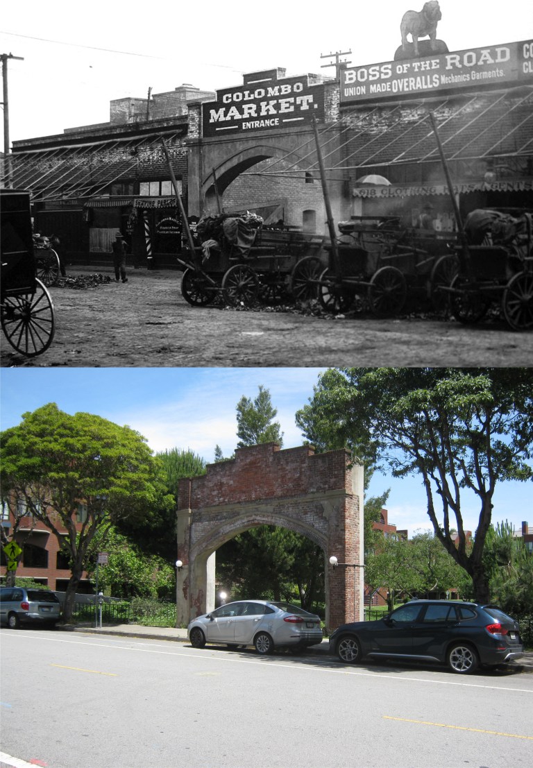 Not far from the Embarcadero is an area once called the Produce District that thrived around the Colombo Market on Front Street and Pacific Avenue. The Produce District and the Colombo Market are gone now, but the archway of the Colombo Market entrance remains. The best look you’ll get on film of the old Produce District is in the 1949 movie ‘Thieves Highway’, starring Richard Conte and Lee J. Cobb. (Skmorton.com and Found SF)
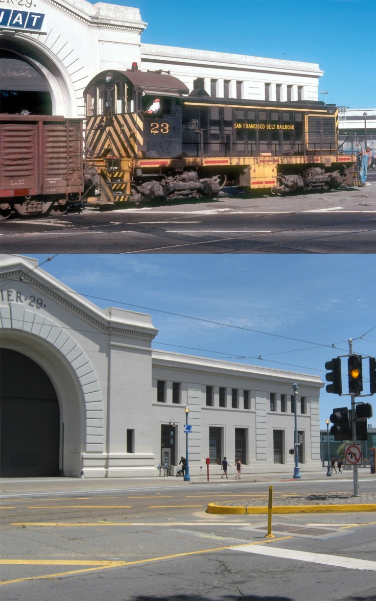 We’ll end our prowl at Pier 29 because I had to walk back and that was good enough for one day. Here, an old Belt Line Railroad engine passes Pier 29 along the Embarcadero in 1977. The railroad line officially went out of operation in 1993. (Railpictures.net)
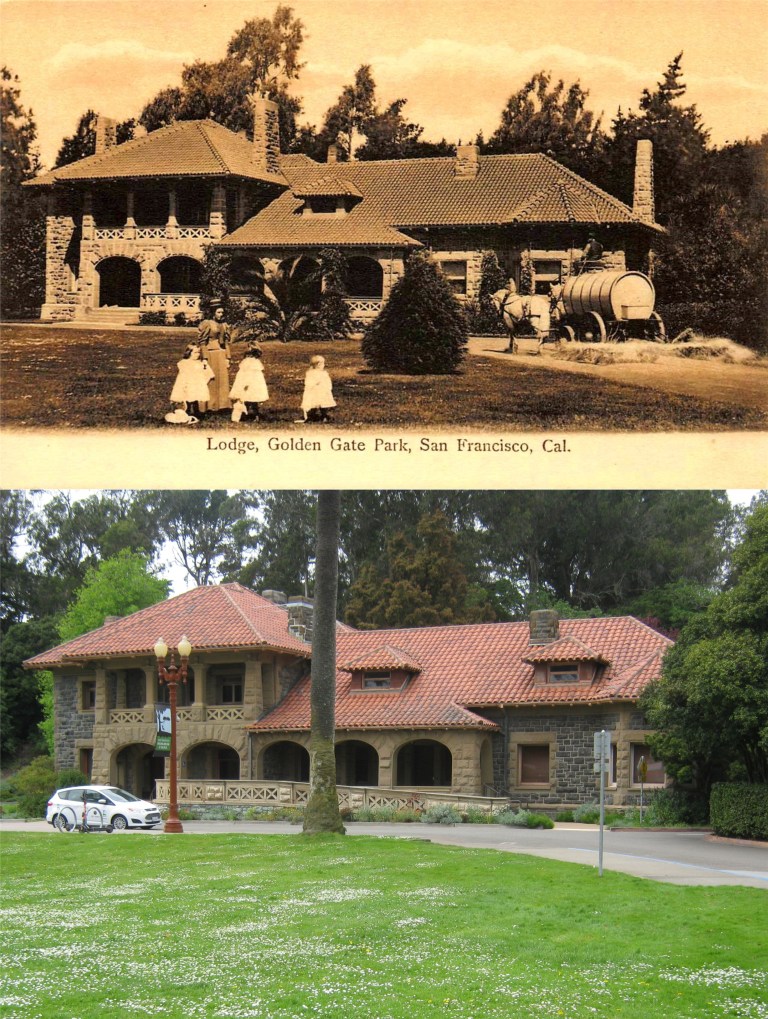 McLaren Lodge in 1907: (eBay)
 Looking south across Kezar Stadium toward the old Polytechnic Gym Building on Frederick Street during a 49ers football game in 1957: Kezar Stadium was demolished in 1989, but the playing field is still there. (An SF Gate photo posted on Pinterest)
 The old Rustic Bridge at Stow Lake, erected in 1893:
 A vintage picture from the Shorpy Collection at Stow Lake with the old Rustic Bridge to Strawberry Hill in the background: Wow, that’s a really classy looking Nissan Versa!
 The lesser photographed bridge that crosses Stow Lake over to Strawberry Hill from the north, seen here in 1955, (the Rustic Bridge crosses over to Strawberry Hill from the south). Boats aren’t available to rent at Stow Lake right now so this was the closest comparison I could get to the vintage picture. (Etsy.com)
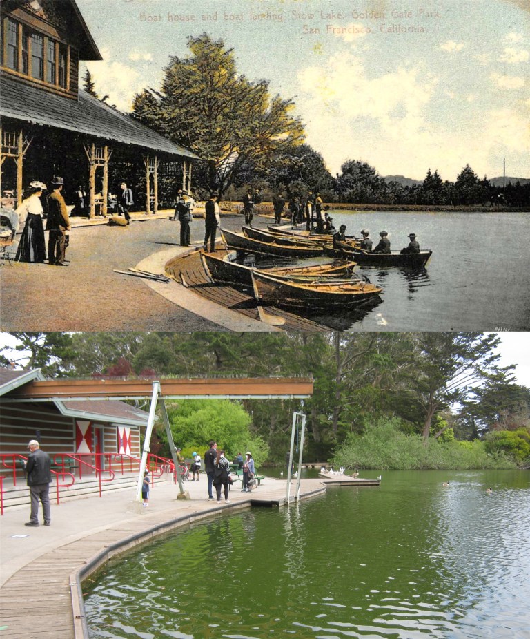 A postcard of the old Boathouse at Stow Lake in 1908 (eBay)
 The Japanese Tea Garden was changed to the Oriental Tea Garden after Pearl Harbor. The name was changed back to the Japanese Tea Garden in 1952. Both pictures are looking toward where the old entrance to the Tea Garden used to be.
 The Children’s Playground after the 1906 Earthquake: The roof of the Sharon Building had collapsed. (SFMTA Photography)
 The fellow with the glasses may not look that imposing, but from the late 1920s through the end of the 1950s he owned The Cliff House, the Sutro Bathhouse and Playland-at-the-Beach. George Whitney poses with his family out the Portals of the Past on Lloyd Lake in Golden Gate Park. (worhtpoint.com)
 The old Murphy Windmill at the southwest corner of Golden Gate Park in disrepair in the 1970s: The restored windmill was reopened in 2012.
 Looking past the children’s playground in the Golden Gate Park Panhandle toward the corner of Oak and Ashbury Streets in a San Francisco Chronicle photo from 1966: The playground is still there, but closed right now due to the Covid-19 pandemic.

