
“Who’s on 1st, What’s on 2nd, I Don’t Know’s on 3rd .” I took a walk around the downtown portions of First, Second and Third Streets, south of Market Street last Friday in the rain, and yesterday. I’m never sure if the numbered streets and avenues in San Francisco are correctly written alphabetized or numeric; I think it’s okay either way. There’s a lot more than the portion of these streets that I covered in my jaunts, but there’s a Denny’s Restaurant on Mission Street between 4th (or Fourth) and 5th (or Fifth) that serves a good breakfast, and I didn’t want to wander too far away from it. Besides even though they’ve done a good job in clearing up the poverty and shabbiness these areas were once known for, there’s still some spots around here that look like a Dorothea Lange photo from the 1930s. (Thumbnail images)

1st and Market Street in 1955: First Street, (Well, I’m not sure, so I’ll just print them both ways during this post) was one of the first streets we walked along from the old Transbay Terminal on Mission Street to get to Market Street when we first started riding the bus over to the City when we were in high school. I remember we once asked a police officer standing on the southeast corner of 1st and Mission how to get to Chinatown. He said to us, jokingly, “Why do you want to go there? Do you want to get shanghaied?” We weren’t sure what the word meant back then, but we were tough kids and we weren’t going to get shanghaied unless we wanted to. When we found out what it meant, it did kind of sound like fun. (Vintage picture, San Francisco Pictures Blog)
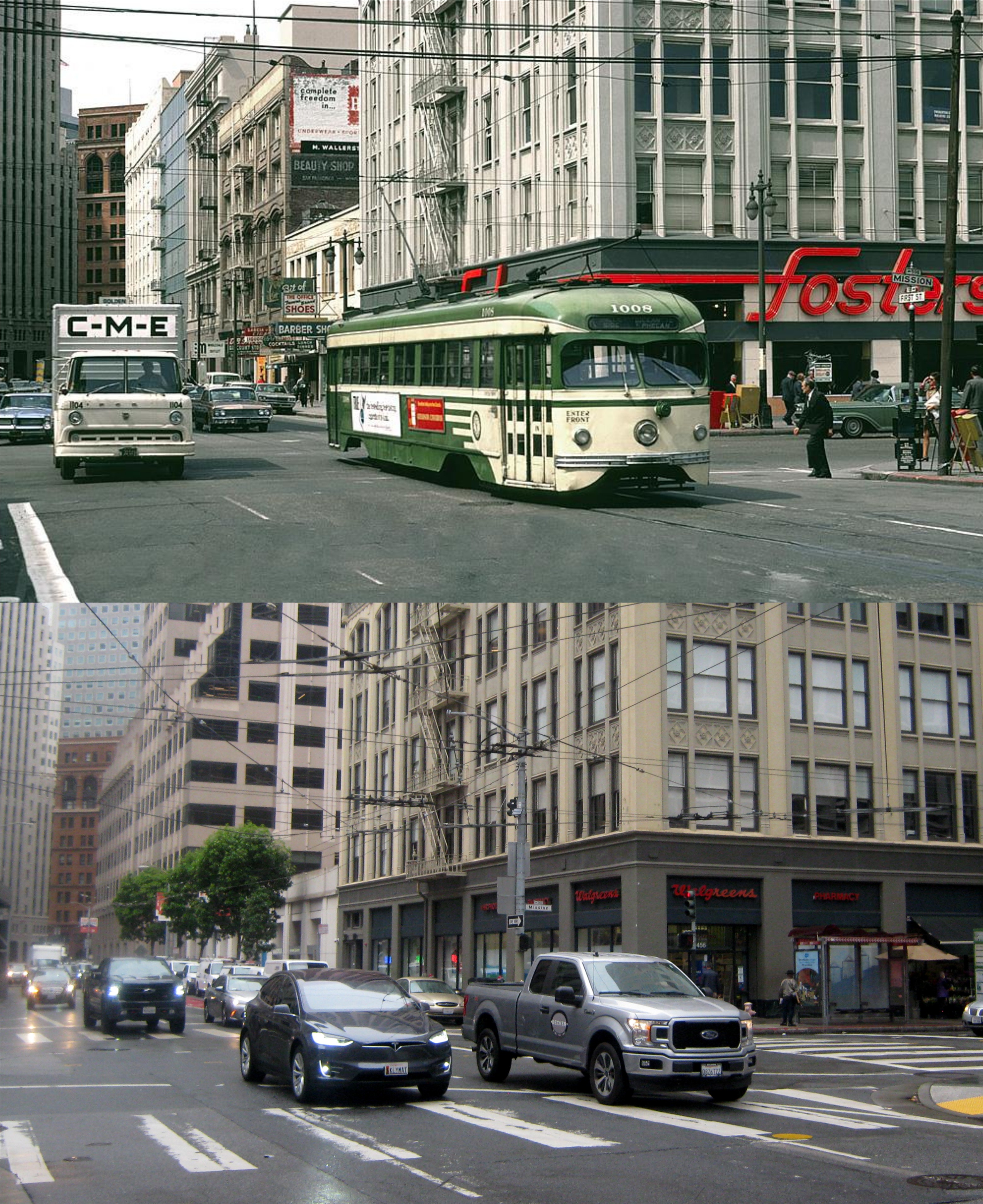
1st and Mission Streets, looking north along 1st in 1970: The southeast corner where the policeman warned us against “danger” is on the right in both pictures. I remember the Foster’s Restaurant in the vintage picture, and the old and new Transbay Terminals were out of the picture on the right. (San Francisco Pictures Blog)
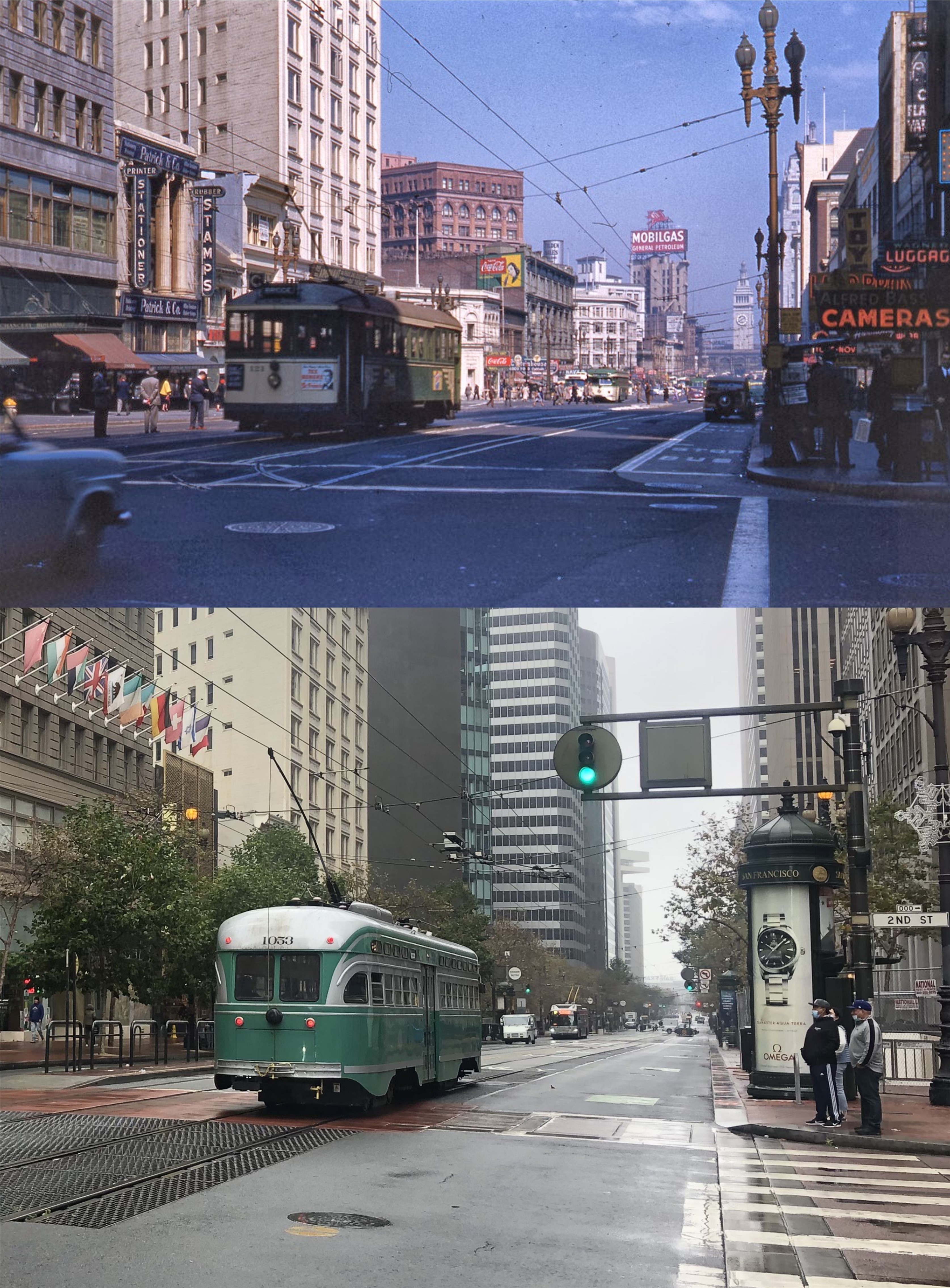
2nd and Market Streets, looking toward the Ferry Building in 1949: When you walk south down Second Street, parts of it haven’t changed much since before World War Two. (San Francisco Pictures Blog)

2nd Street, looking past Stevenson Street toward the Hobart Building in 1917: The Hobart Building, built in 1914, is one of my favorite buildings on Market Street. I didn’t always feel that way. When we were teenagers we snuck up into the tall steel framed Wells Fargo Building north of the Hobart Building. I remember looking down at the Hobart Building and thinking that they needed to replace that old eyesore with a modern building like the one we were in. Boy was I cemented in the present during high school! When I walk by here now, I admire with respect the old Hobart Building, and I don’t pay any attention to what was once the Well Fargo Headquarters Building. (opensfhistory.org)

3rd Street, looking south from Market Street in 1914: In a murder mystery he wrote in 1948 titled ‘Many a Monster’, Robert Finnegan describes Third Street this way;
{Third Street, commonly called Skid Row or Skid Road was the street of down-and-outers, lined by pawn shops, junk stores, cheap saloons and gaunt-looking hotels. Here and there a ragged drunk slept in a doorway with an empty bottle clutched to his breast. Prostitutes, fat and dowdy, thin and tuberculous (sic) wandered in and out of barrooms on crooked heels.}
Projects like the Yerba Buena Center and the San Francisco Museum of Modern Art pretty much put an end to that era. (SFMTA / San Francisco Pictures Blog)

Looking north on 3rd St, between Folsom and Harrison Streets in 1915: In the far background is the crown of the old Call Building, to the right of it is the gothic looking Mutual Savings Bank Building; both survivors of the 1906 Earthquake and Fire. The Call Building, now known as Central Tower, can barely be seen from here now. The old Mercantile Building on Third and Mission Streets, another survivor of the 1906 disaster, is to the left of the Mutual Savings Building, behind the OWL Cigars sign in the vintage picture . (San Francisco Pictures Blog)

Did I ever mention the numbered streets in Montara? The first street to exit Highway One on from the North was Second Street. First Street looked like a dead end driveway, and was only a part of a block long, so was ignored. I sort of forgot it was there. The signs were like, ‘Second’, ‘Third’, ‘Fourth’, and so on, but without a ‘First’. That was actually in the older Faralone City, which was on the Highway. Montara was to the East of that. The perpendicular streets in the Montara part of town were named after trees, and arranged alphabetically, such as ‘Acacia St’, ‘Birch St’, ‘Cedar St’, ‘Date St’ (where my Pa lived) and ‘Elm St’, which was almost the edge of town. There was only one block of a street east Elm Street, and it was a short distance south of where Elm Street ended, so did not seem like it was in the same pattern. Nonetheless, it was also named after a tree that accordingly started with ‘F’. Yes, it was Fir Street, which was spelled as ‘Fir St’! It looked so silly to have the numbered streets so neatly numbered, but to have what looked like ‘First’ (‘Fir St’) several blocks away, and completely out of chronology! You can look it up on a map.
Wow, that’s a very interesting memory, Tony! I don’t get to Montara often, but the next time I go there, I’ll be looking for both First and Fir Streets. Interesting that they would name so many streets after trees where your father lived.
You would not likely see Fir Street. It is several blocks east of the Highway, and off of the primary streets. Streets are commonly named after trees, but in Montara, it is weird for a street to be named after a date palm. I suppose that the Canary Island date palm was trendy at that time, like in San Francisco. Montara was inhabited by crazy artists back then.