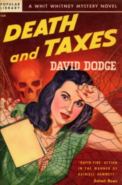
Although, for about the third year in a row the Internal Revenue Service has found a way to postpone the second part of that famous axiom, temporarily. The latest update is that the IRS will not process any tax returns until January 29th 2018. That gives me a little time to catch up on my reading. While perusing through Don Herron’s excellent book ‘The Literary World of San Francisco and its Environs’, I learned about a series of mysteries written by David Dodge from 1941 until 1946 featuring an income tax accountant named Jim “Whit” Whitney. In the first book, ‘Death and Taxes’ written in 1941, Whit and his partner of their accounting firm, George MacLeod, are promised a large bonus if they can gather information concerning an overpayment of taxes four years earlier by a murdered bootlegger, and file an amended return for a refund for overpaid taxes due to the estate. Apparently, people had four years to amend tax returns in 1941, unlike the three years allowed today. After MacLeod is murdered in the 4th Chapter, Whitney becomes a clay pigeon for the murderer himself as he races around San Francisco and other Bay area locations to solve the murder, and also to collect the information he needs to amend the original return for the bonus of $50,000.00 that will now be all his. Whit is a likeable fellow, (well, most tax accountants are lovable characters) but he drinks an enormous amount of booze throughout the book. If I drank as much as Whit does, every one of my clients would be audited! I’ll go through some of the highlights for you without giving away too much information to spoil the ending.
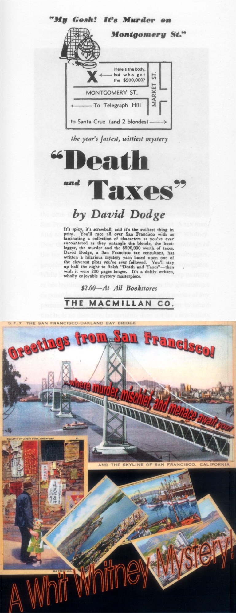 These are two illustrations from the most recent publishing of the book. The top image looks like it may have been from the first edition in 1941. Among the postcards from the back cover is one showing the Bay Bridge. The way the words “where murder, mischief, and menace await you” move across the bridge is prophetic concerning the denouement of the story.
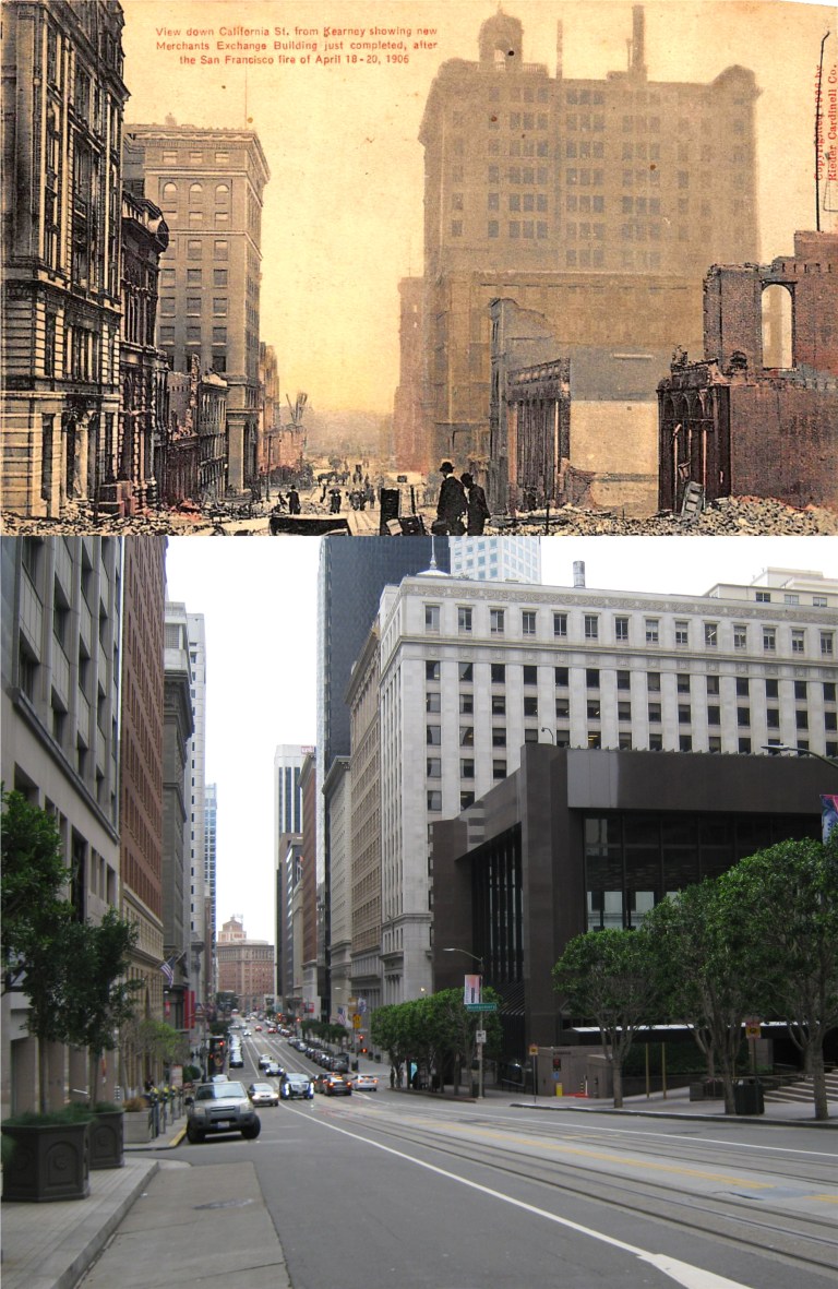 Whitney and MacLeod worked on the eighth floor of the Merchants Exchange Building on the south east corner of California near Montgomery Street. The building is called “The Farmers Exchange Building” in the series. Built in 1904 and a survivor of the 1906 Earthquake and Fire, the Merchant Exchange Building is the tall brown building second from the corner on the right in my photo. The grey building in front of it is 300 Montgomery Street. This may have also been where their office was because the book often refers to its location as being at “Montgomery and California Streets”. Both pictures were taken near Kearny looking down California Street.
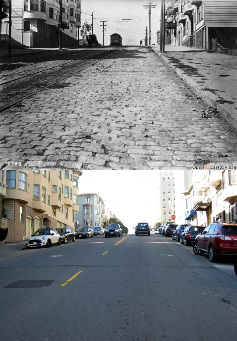
 In the second book in the series, ‘Shear the Black Sheep’ written in 1942, Whitney catches a cable car at Montgomery and California Streets heading up Nob Hill. He narrates one of the most descriptive accounts of a cable car ride I’ve ever read! (after ‘The Ballad of the Hyde Street Grip’) I don’t know if you can pack a hundred people on a cable car, but it’s nice to think so.
{A cable car was creaking up California Street. Whit stepped off the curb, dodged a delivery truck, broad-jumped a pool of water and caught the car as it rattled by at a steady six miles an hour. The Saturday afternoon exodus from the financial district was in full blast, and he had to squeeze to find standing on the step that ran the length of the open car. A hundred people clinging to the straps, railings and protuberances of a vehicle designed to accommodate forty left not much room for the next man, but Whit was an old cable car rider and managed to get a handhold and both feet planted on the step. By keeping all of his muscles tensed he could hold his head far enough inside the car so that the rain dripping from the edge of the roof hit the back of his coat instead of his face. In that familiar position he hung on as the car crawled up the thirty degree slope of Nob Hill, while the wind played merry hell with his coat-tails.}
The vintage picture was taken where Whit caught the cable car around the same period. (OpenSFHistory.org)
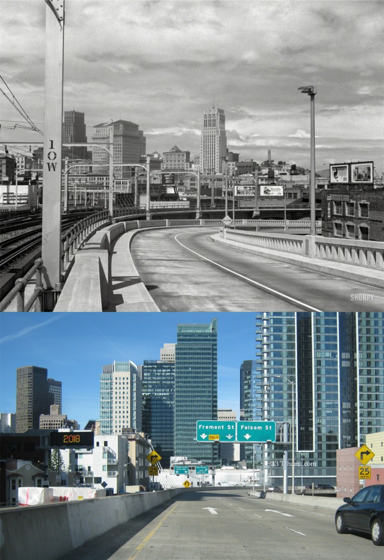 Back to ‘Death and Taxes’ and more of the story: In one of their trips back across the Bay Bridge from the East Bay in search of clues, Whit and the police exit at the First Street off ramp, now the Fremont Street off ramp.
{The police car turned down the First Street ramp, and its tires sang as the driver pulled it around the curb. At the bottom of the ramp they turned left, crossed Market and started up Front Street.}
In the vintage picture taken by Dorothea Lange you can see the Russ Building, the Standard Building, the Shell Building and Coit Tower, none which can be seen from the exit today.
 Whitney is assigned a bodyguard by the police named Larson. After a dinner in North Beach they drive up Union Street to Russian Hill to visit Marian Wolff, one of the main characters and suspects in the book. Heading up Union Street they turn left onto Leavenworth. As they park at Marian’s apartment a passing car fires a shot into their car seriously wounding Whitney. The vintage photo is looking west on Union street where they turned left onto Leavenworth taken in 1910. You can see some of the wooden boards on the building with the bay windows in the upper left in the current photo. (OpenSFHistory.org)
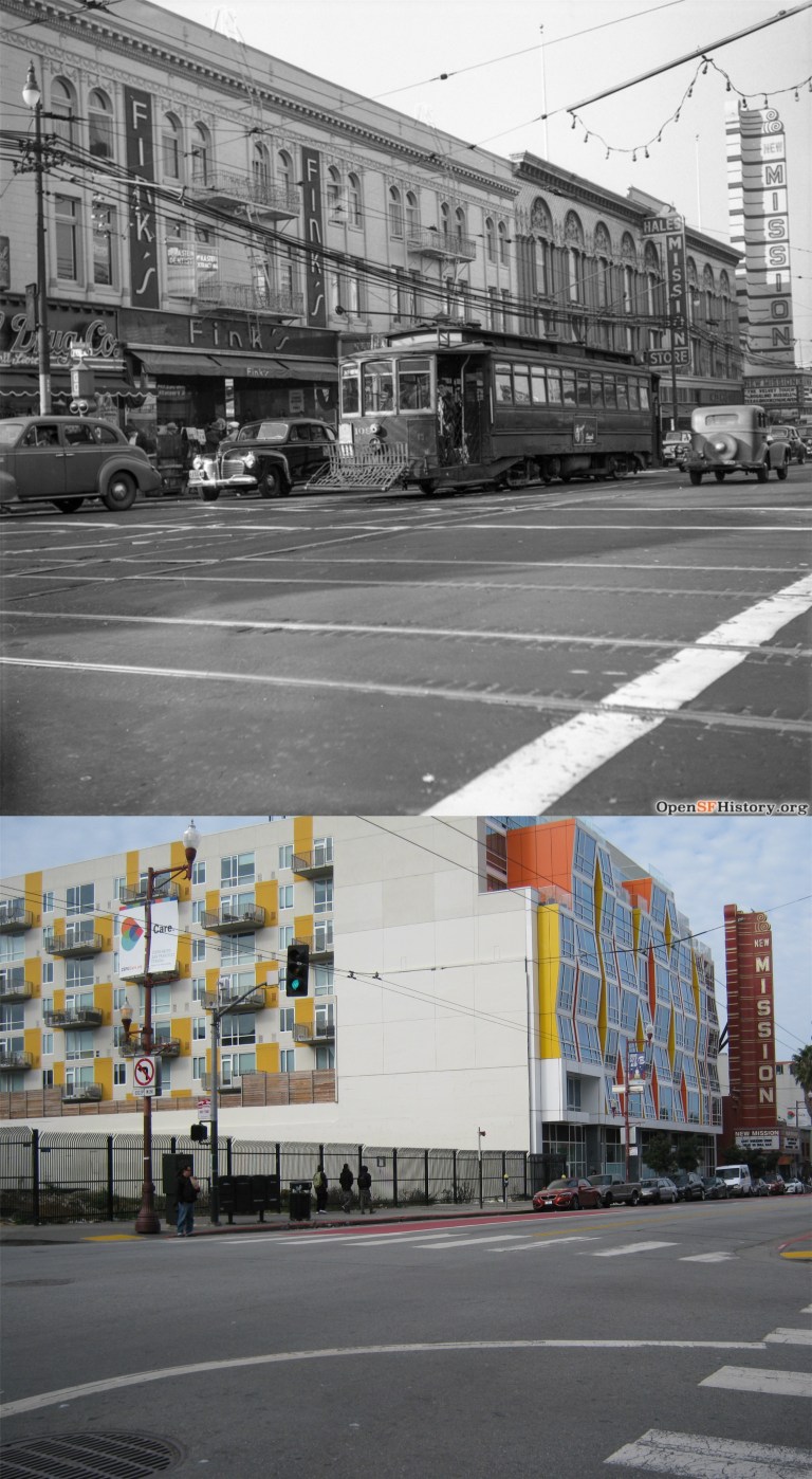
 One of the highlights of the novel is a gunfight involving a car full of bad guys and police in the intersection of 22nd and Mission Streets. Lieutenant Webster in a car with Whitney riding along are tailing a car with suspects as it approaches 22nd along Mission from the north. A third car pulls along side of the car the police are following it enters the intersection. Suddenly, the number one suspect, an airplane pilot named Carpenter is spotted standing in front of a drugstore on the corner of 22nd and Mission by Webster.
{Webster held a gun in his lap and waited for a break. When the Buick was halfway across 22nd he saw the aviator standing in front of the drugstore. He said, “Jesus, it’s Carpenter” kicked open the door of the sedan and jumped into the street.” “The Buick was opposite the drugstore and as the gunman in the rear seat leaned forward to shoot at Carpenter, the brown touring car speeded up and hit the Buick’s rear bumper. The bullet shattered the drugstore window two feet beyond Carpenter. The aviator pulled a gun from under his arm, fired twice at the Buick, and ducked back around the corner. He was running diagonally across Twenty-Second Street when Webster took careful aim and shot him in the leg.}
A long descriptive gun battle follows in the 22nd and Mission Street intersection between the cops and bad guys leaving smashed up cars and one of the hoodlums dead. The vintage picture from OpenSFHistory.org shows traffic heading into the intersection at 22nd Street coming north from Mission in the 1940’s. Another OpenSFHistory.org picture at 22nd and Mission Street taken in 1961 shows that there was a drugstore on the corner of the intersection once.
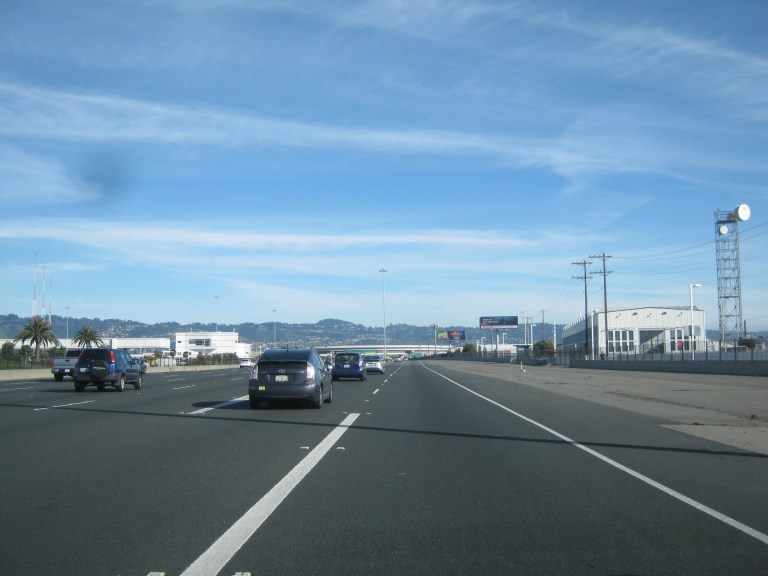
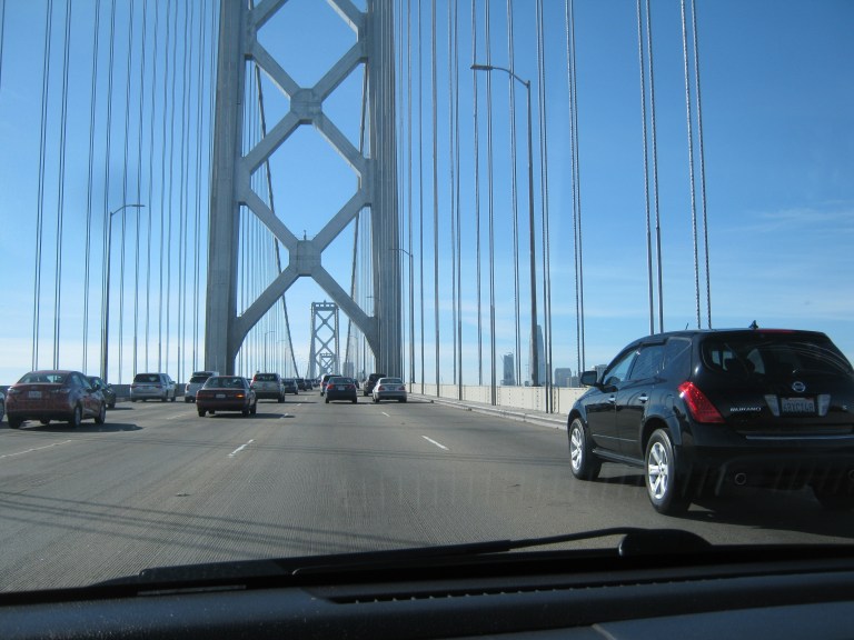 The finale of the book involves a chase between police and the murder (or murderess, I’m not giving anything away) east along the Bay Bridge. That was what I was referring to earlier about the old San Francisco postcard with the words racing across the upper deck of the bridge. They would be heading toward where I’m driving here, but on the left side because the upper deck was two-way traffic in 1941.
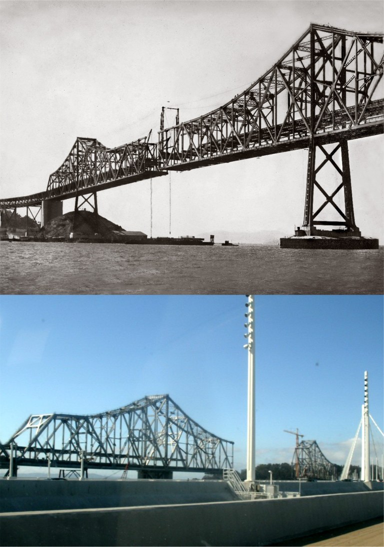 The chase moves into the old cantilever span of the Bay Bridge heading toward the toll gates on the east side of the bridge. The vintage photo is of the cantilever bridge nearing completion in 1936, and a photo I took from the new eastern span of the bridge when they were demolishing the old section.
 The chase ends at the toll gates on the Oakland side of the bridge. Back then cars paid a toll when they entered the Bay Bridge from Oakland and again when they left the bridge returning to Oakland about where I’m approaching.
{The siren wound up to an ear-splitting shriek. Men moved quickly at the toll-gate and a bar across one of the entrances swung away.” “Whit looked at the narrow passageway between the concrete pillars of the gate and closed his eyes. The siren howled, the car bucked suddenly and they were through. Whit swallowed and opened his eyes again. He looked back to be sure the gate was in one piece.}
I’d better close it off now before I reveal too much, but needless to say Whit ends up celebrating with a lot of highballs and a pretty girl.

 Turk, Mason and Market Streets after the 1906 Earthquake and Fire:
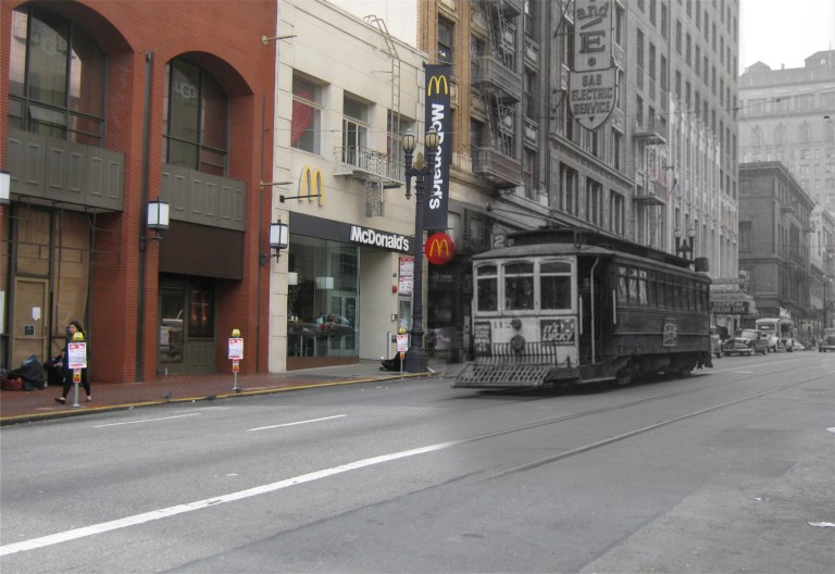 Sutter Street between Powell and Stockton Streets in the early 1950’s:
 Grant Avenue at California Street during World War Two with Old St. Mary’s Church on the right:
 Downtown San Francisco during the 1906 Earthquake and Fire:
 It always amazes me that Charlie Chaplin stumbled down these exact steps on Alice Street in Oakland one hundred and three years ago in his movie short ‘A Night Out’ from 1915.
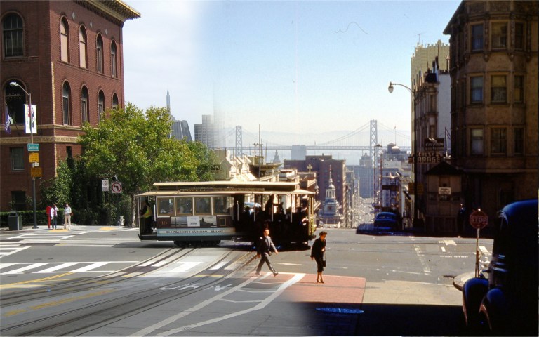 California and Powell Streets during the 1950’s:
 Grant Avenue at Filbert Street in the 1952 movie ‘The Sniper’:
 Humphrey Bogart on Hyde Street at Greenwich in the 1947 film ‘Dark Passage’:
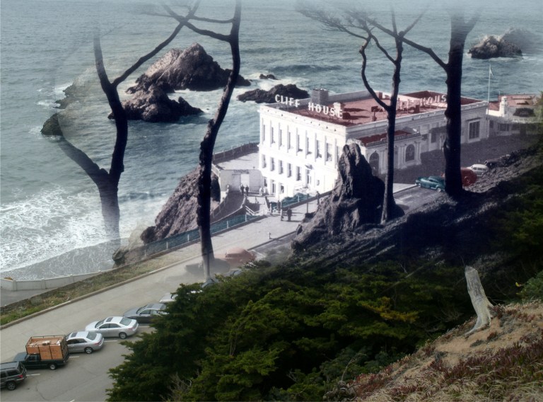 The Cliff House from Sutro Heights in 1949: Actually, you can barely see the famous restaurant from here anymore because of the overgrown trees.
 Powell Street at O’Farrell Street during the 1950’s:
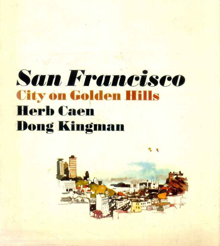 Dong Kingman was a Chinese American artist who first gained recognition as a Works Progress Administration painter during the 1930’s. Wikipedia writes of him as “one of America’s leading watercolor masters.” In 1967, “Kingman”, as he preferred to be called, co-created a book about San Francisco along with columnist Herb Caen entitled ‘San Francisco – City on Golden Hills’. In the preface Caen writes, “It is entirely appropriate that Don Kingman should be my collaborator on this book, for San Francisco – the city of his heart and mine – has been spiced and enriched by the strong flavor of China ever since it came of age as a world metropolis.” The text by Herb Caen is accompanied by paintings from Dong of a modern San Francisco, many that now seem nostalgic. Dong Kingman died in May of 2000. These are then and nows of some of his paintings from the book.
 California Street, looking down toward Chinatown and Old St. Mary’s Church before the skyscraper boom of the late 1960’s:
 Maiden Lane, looking toward Stockton Street and the St. Francis Hotel: Dong has the Dewey Monument in Union Square a little closer to the south side of Maiden Lane than reality, but that’s art.
 Market Street at the Embarcadero across from the Ferry Building looking south: Some of the structures in the background are the Bay Bridge, the Embarcadero Freeway, and the YMCA Building. The block of buildings where the Ensign Café was at were demolished at the end of the 60’s.
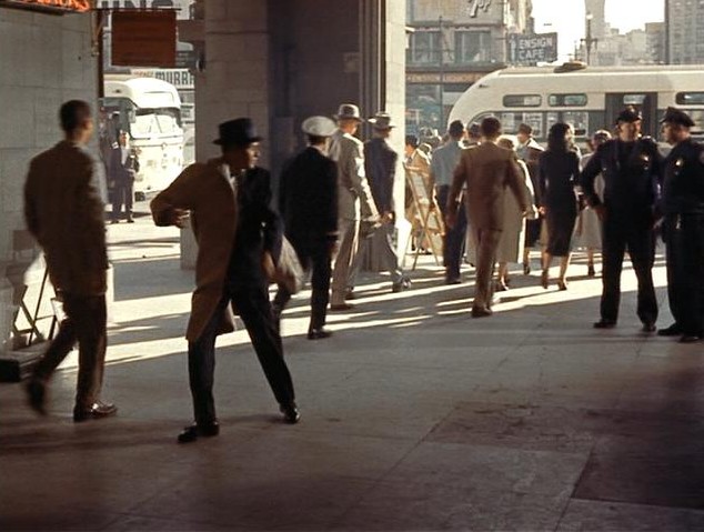 You can see the Ensign Café in a scene from the 1957 film ‘Pal Joey’ where Frank Sinatra dodges from the police across the street at the Ferry Building.
 Candlestick Park before it was enclosed in 1971 to accommodate the San Francisco 49ers football team moving in:
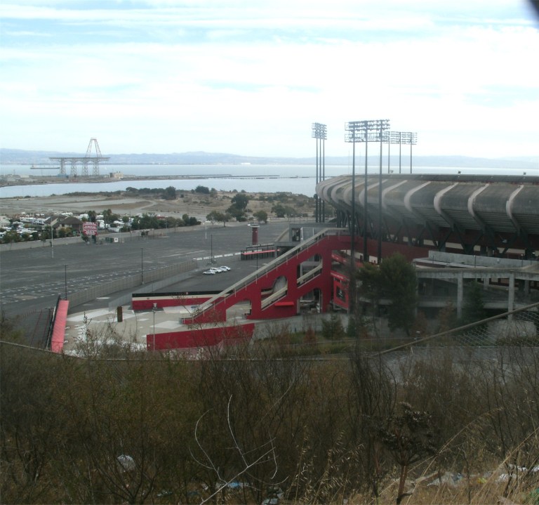 Another view of Candlestick Park from the hill behind it taken during the year it was demolished in 2015. Ah, what fun we had at that place, family and friends!
 When you stand on Hyde Street between Chestnut and Bay Streets looking toward the Bay and Alcatraz Island, you’re looking at one of the most beautiful views in San Francisco.
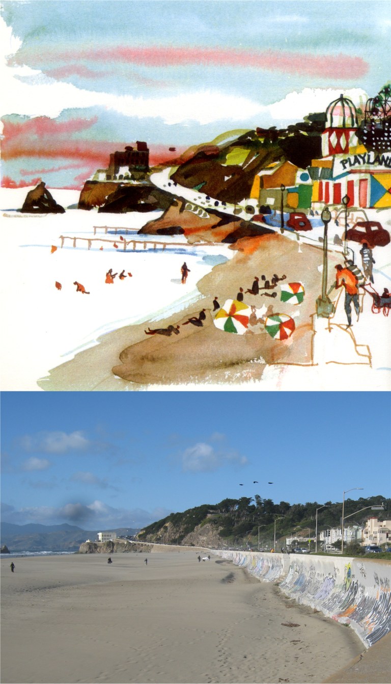 Ocean Beach at the Great Highway, looking toward the Cliff House and the long gone Playland-at-the-Beach: Playland was where the condominiums on the tight are today.
 The eastern side of the now remodeled Broadway Tunnel on the edge of Chinatown: That’s a Mason Street cable car, a line that still exists, passing by on the right in Kingman’s painting.
 Flat Stella at the Cliff House: She got kind of messed up when I threw her in the Pacific Ocean, but she was better later on after she stopped coughing.
 Stella in Chinatown: I told her that the Chinese are very big on paper ornaments so if she didn’t behave herself, I’d sell her into paper slavery.
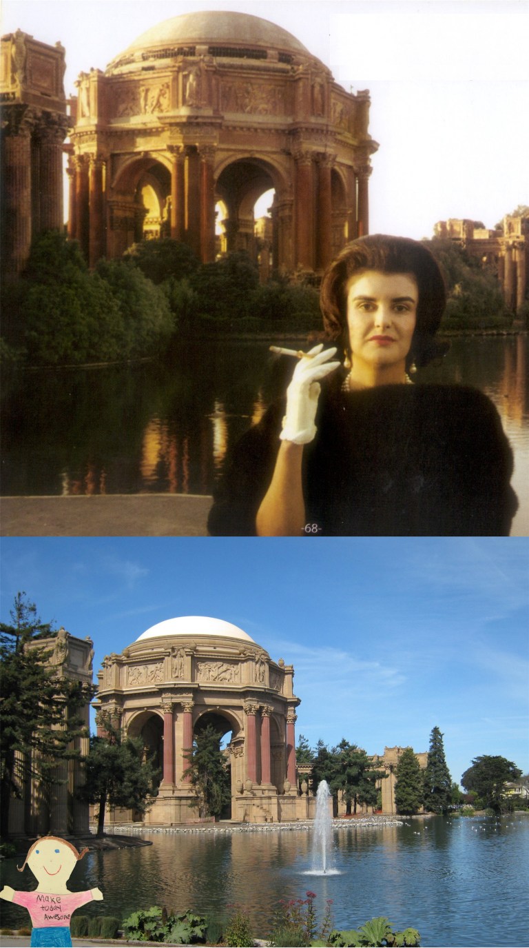 Stella at the Palace of Fine Arts: Stella said to me that the lady in the old picture was weird looking. I said to her “People who live in glass houses shouldn’t throw stones.”
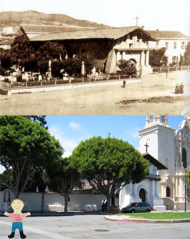 Stella at the oldest church in San Francisco, Mission Dolores: Stella asked me who Dolores was. I just told her that she was Father Junipero Serra’s big sister.
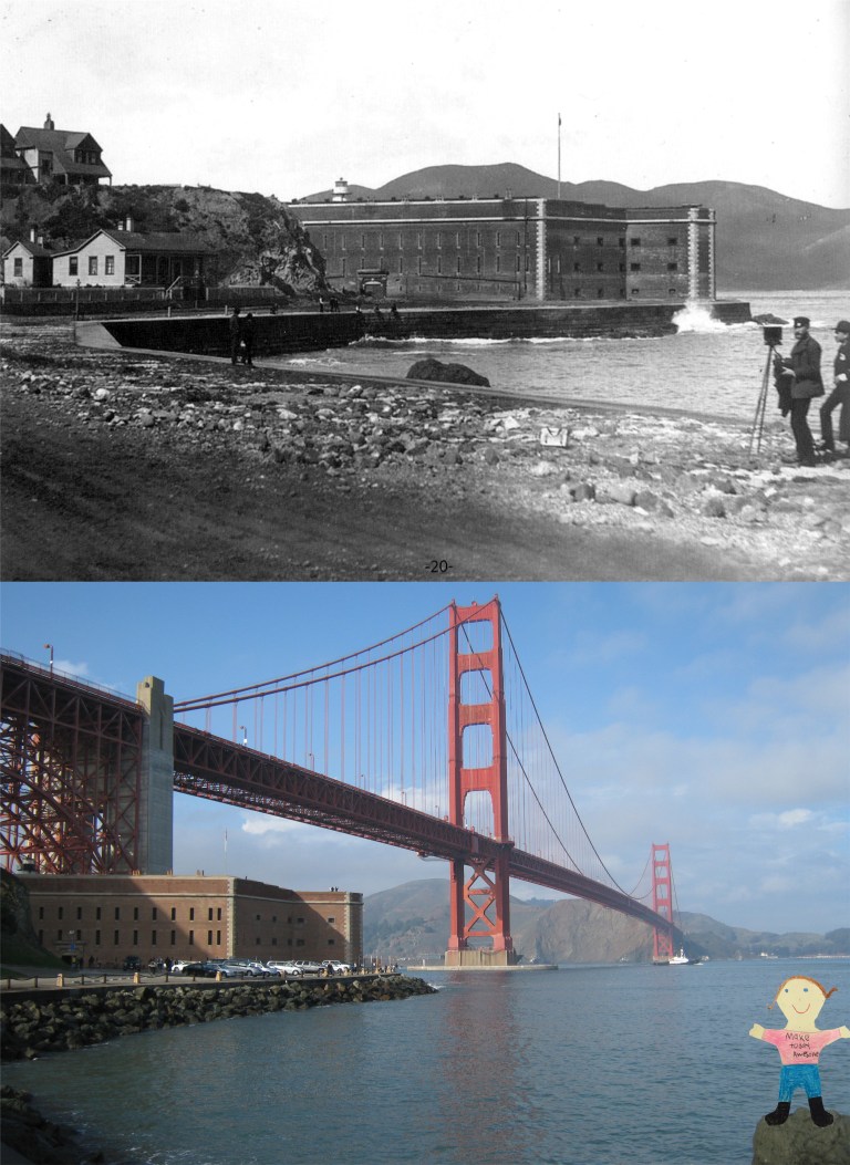 Stella at the Golden Gate Bridge: Stella was really impressed with the bridge, and she asked me if it was real. Everybody started laughing at her, and I kind of felt sorry for her!
 Karl Malden played Inspector Michael Stone and Michael Douglas played Inspector Steve Keller. They got along just as well with each other as Napoleon Solo and Illya Kuryakin did in The Man from U.N.C.L.E. and saved each other’s life about as often. Here they are at the old Rustic Bridge at Stow Lake in Golden Gate Park. In the dialog at this point Malden is saying, “It’s so peaceful, we should come here more often.” This is about one of the most peaceful spots in San Francisco. The path is different and there are more trees here now.
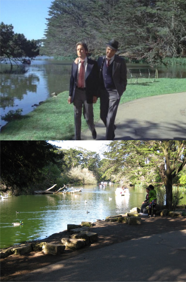 They walk along Stow Lake past the bridge for awhile.
 In one episode Steve Keller actually sleeps with one of the costars. That was a rarity! However, they didn’t live happily ever after. The girl he’s sleeping with, Brenda Vaccaro, turns out to be a hit lady for the mob who’s killed at least ten people. Somehow, that’s not a turn off to me! Maybe, it’s a “guy thing”. At the end of the episode, she goes to the Palace of Fine Arts to make another “whack”.
 This was about where she was sitting.
 Keller confronts her after the killing at the Palace, and finds out who she is. He hesitates shooting her. Well, that’s love!
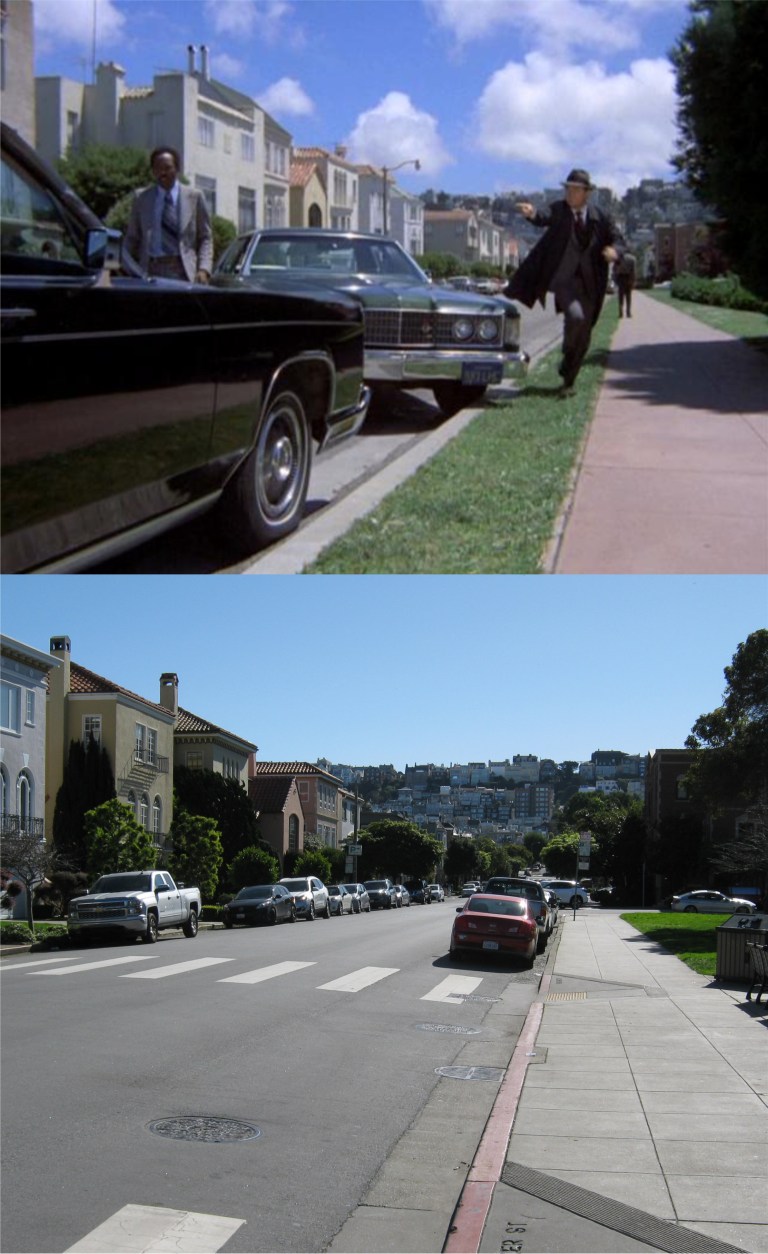 Papa Cop, Stone, pulls up here on Baker Street just in the nick of time.
 Stone prevents her from spoiling every good memory Keller had of her, and she’s off to jail.
 Now, off to Mission Street and the Embacadero under the old Embarcdero Freeway where there’s Salvation Army Band playing music to the winos in the area. This may have been one of the corny moments I was telling you about.
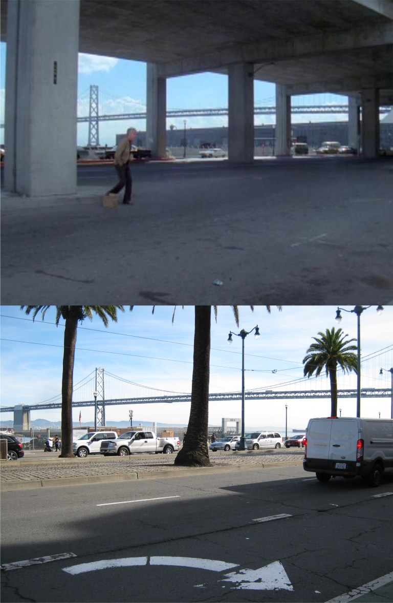 A miserable drunk stumbles across the Embarcadero. Oh, wait, that’s not polite! I mean, an intoxicated homeless person finds comfort in the bottle while living on the streets.
 Why, it’s Leslie “Don’t call me Shirley” Nielsen! Nielsen plays an alcoholic cop who accidentally gets his partner killed while drunk on the job.
 “Well, time for a little R&R!” They sure tidied this spot up today. That’s the old YMCA Building in the background.
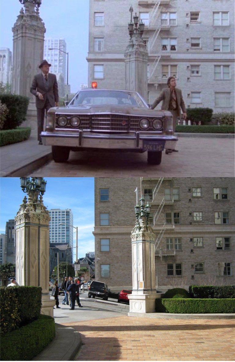 Hot on the scene of another murder, the boys pull into the old Brocklebank Apartments on the northeast corner of Mason and Sacramento Streets, Nob Hill. The entrance to the Brocklebank is very similar to the entrance of the Mark Hopkins Hotel.
 Keller heads across California Street from the Mark Hopkins Hotel to a telephone booth.
 “Welcome to Tenderloin Travel.”
 There was some type of busy terminal here once but it couldn’t have been an airport. The “Airlines Terminal” sign may have been doctored for the episode. There’s a Hilton Hotel here now.
 As the boys say goodbye to Stefanie, we’ll say goodbye to the boys. Karl Malden is dead now, and I don’t read much about Michael Douglas’s health nowadays. I hope he lives as long as his dad has.
 One of the best pictures of the Crest Garage, and also one of my favorite vintage San Francisco pictures, as two cable cars from the California and Powell Street Lines cross the intersection in the 1940’s. The Crest Garage can be seen behind the cable car on the right in my picture.
 Here’s another then and now of the Crest Garage from the 1940’s that I posted in November of 2016.
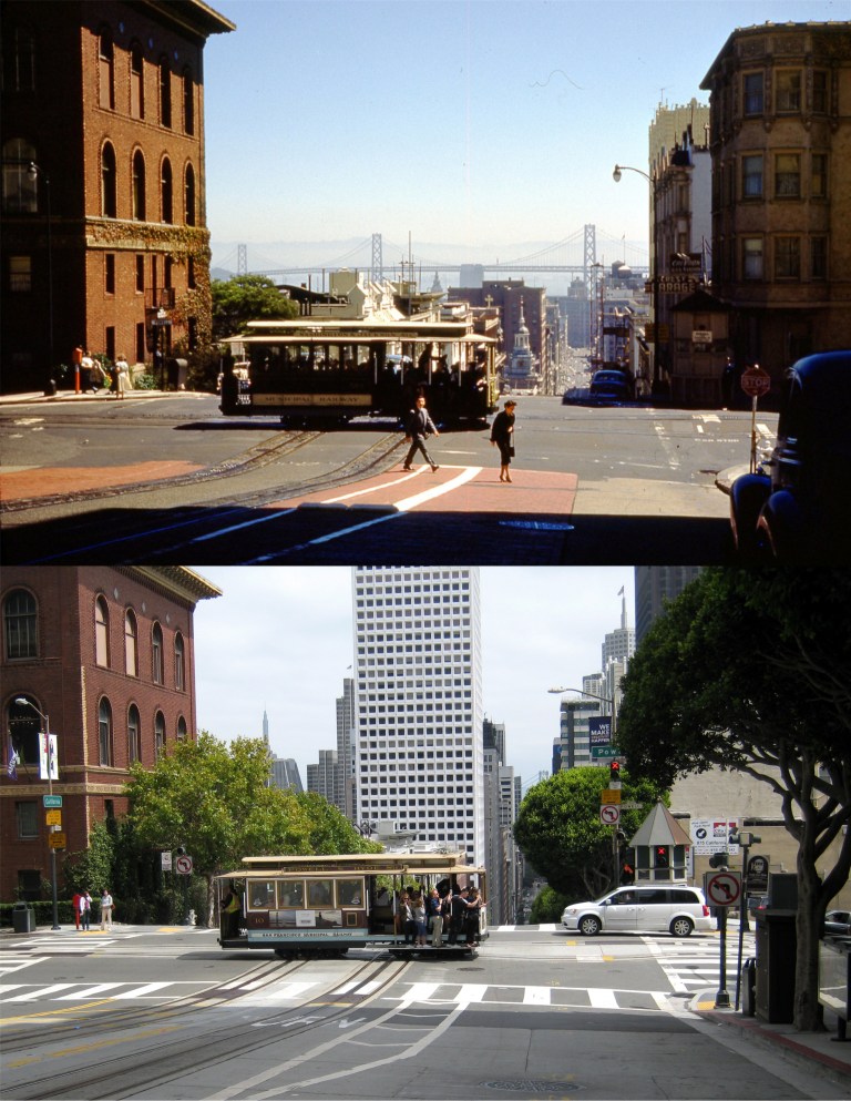 In another picture, this one from the early 1950’s just across California Street from the previous picture, the Crest Garage is on the far right in the old photo from Vintage Everyday and with the arrow sign on it in my picture. The apartment building between the garage and Powell Street was demolished by the 1990’s.
 In the 1964 movie ‘Good Neighbor Sam’, Jack Lemmon races his Thunderbird past the Crest Garage which by that time had become a Flying A Service Station.
 In a 1968 episode of the television show ‘Ironside’ starring Raymond Burr, the Crest Garage had by then become a parking garage. My picture of the garage behind the cable car signal box taken in August of 2017 was the last picture I took of the building.
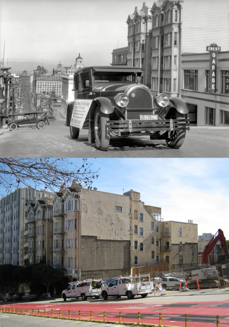 The oldest picture I’ve seen of the Crest Garage dating from the 1920’s; I’m not sure but it might be from the Shorpy Picture Archive. The bottom photo is all that’s left of the garage today. You can see the imprint of where the Crest Garage leaned against the old Apartment building on California Street since the 1920’s.
 The Powell Street Cable Car Line: Pretty girls are pretty girls no matter what century.
 Chinatown in the 1940’s:
 The Golden Gate Bridge Promenade in the 1940’s:
 Maiden Lane in the 1950’s:
 Clipper Cove at Treasure Island: When I took the recent picture of the new eastern span of the Bay Bridge the old cantilever bridge hadn’t been demolished yet.
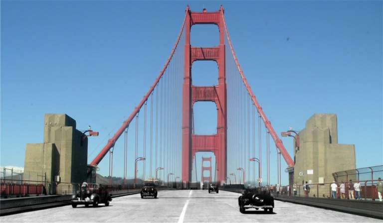 The Golden Gate Bridge in 1940:
 When trains and streetcars roared under the Ferry Building Pedestrian Bridge
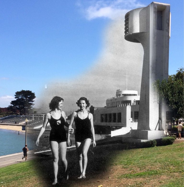 Bathing Beauties at Aquatic Park in 1939:
 Danny and I at Ocean Beach, I think it was around 1898. I’m a lot older than I look!
 I like the breakfasts at Tad’s Steakhouse on Powell Street just north of Ellis and often get an early start on the day there when get off at the Powell Street BART Station. The vintage picture from OpenSFHistory.org was taken roughly at the same area looking back toward the Flood Building during the 1906 Earthquake and Fire.
 It wasn’t a hangout of mine, but just up from Tad’s in the green building in the center was the world famous ‘Omar Khayyam’s’ Restaurant. The vintage picture from OpenSFHistory.org was taken in the early 1950’s. The restaurant was destroyed by a fire in the 1980’s.
 The top two pictures were taken at the southeast corner of Powell and Bush Streets. Right on this corner, just up from Union Square is Roxanne’s Café. They not only serve good breakfasts, but I often take advantage of their spaghetti and meat balls when I’m in the area. It’s nice to watch the cable cars clanging up and down Nob Hill while I’m having lunch there. The bottom photo is from my usual table when I stop there. The vintage picture from OpenSFHistory.org was taken in 1958.
 Sometimes, I’m only in the mood for a fistful of French fries in one hand and some chicken nuggets in the other. I usually stop in at the McDonald’s here on Sutter Street between Stockton and Powell when that urge hits me. It’s often crowded, but there’s seating upstairs, and sometimes it’s all I’ll need to make it to dinner. The Sir Francis Drake Hotel is on the corner at the right. The vintage picture from OpenSFHistory.org was taken in October of 1948.
 I used to go to #9 Fishermen’s Grotto for lunch when I was at the Wharf, but when they closed down for so long because of a change in ownership. I started going regularly to Alioto’s; either way you’ll do okay. The Grotto has recently reopened, but I haven’t checked it out yet. (Vintage photo from Foundsf.org)
 It was sad to drive by Mason and Bay Streets on Christmas Day and learn that they finally tore down the old Ginsberg’s Pub. What fun we had there during the 1980’s and 1990’s! In fact, I was in there at 5:04 PM on October 17th 1989. A buddy named Mike and I drove through the old Cypress Structure, crossed the Bay Bridge and headed to Candlestick Park to try to buy tickets from scalpers for the third game of the 1989 World Series. As I remember the lowest price was $300.00 dollars each, which was more than we had at the time. So, we headed for Ginsberg’s Pub. We had just settled in with a hot dog and pitcher of beer when the Loma Prieta Earthquake struck. I went outside of the pub after the shaking stopped and the first thing I saw was a dog running in panic north on Mason Street. Then I looked around at the eerie stillness at twilight of San Francisco with all of the power out. After that, was one of the longest nights of my life trying to leave San Francisco. All of the bridges were closed, I was out of gas, and San Francisco had no electricity. I’ll always think about that night when I pass this corner. I took the top photo on October 17th 2009 after Ginsberg’s had closed.
 Another “quick fix” place I enjoy is the Presidio Bowling Alley. They serve a pretty good hamburger and a ton of fries at the grill there, and healthy stuff too! The bowling alley sits at the southern end of the parade ground of the old historic Montgomery Barracks. I took the top photo looking toward the barracks in December of 2009. That black Mitsubishi pick up truck is mine. It has close to 220,000 miles on it to date and I still drive it. I had a chance to talk with two more nice people here when I took the current picture, Kim and Nate, who work at the Presidio. It was great to listen to them talk about some of the history of the Presidio as well as some of the future plans for the historic army base.
 I enjoy the area of the Cliff House Restaurant and I go there as often as I can. Although I love the Cliff House, more often I’ll have breakfast or a burger at the Louis’ Restaurant just up Point Lobos Road from the Cliff House. The views of the Pacific Ocean and the old Sutro Bathhouse ruins are just as good as you can get from the more famous restaurant. The vintage photo was taken in 1966 the day that Sutro’s burned down.
 We’ll start at the southwest corner of Golden Gate Park and the old stone streetcar bridge that used to span what is now Martin Luther King Jr. Drive, circa 1910. Behind the bridge is the Murphy Windmill. The bridge was anchored into the hill on the left in my photo. Charlie Chaplin filmed a scene driving under this bridge in his 1915 comedy ‘Jitney Elopement’. (Vintage photo, C. R. Collection)
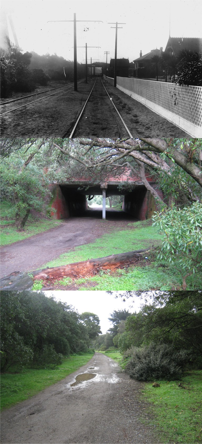 The streetcar line ran along the western side of Golden Gate Park and passed through a tunnel under what is now John F. Kennedy Drive. The vintage photo is looking north toward the tunnel from the tracks in 1903. To the left can be seen the Dutch Windmill at the northwest side of the park. The buildings on the right side of the tracks are gone now. You have to get closer to see the tunnel from where the tracks ran today, as in my middle picture. The third picture at the bottom is looking back along where the streetcar line ran. (Vintage photo, C. R. Collection)
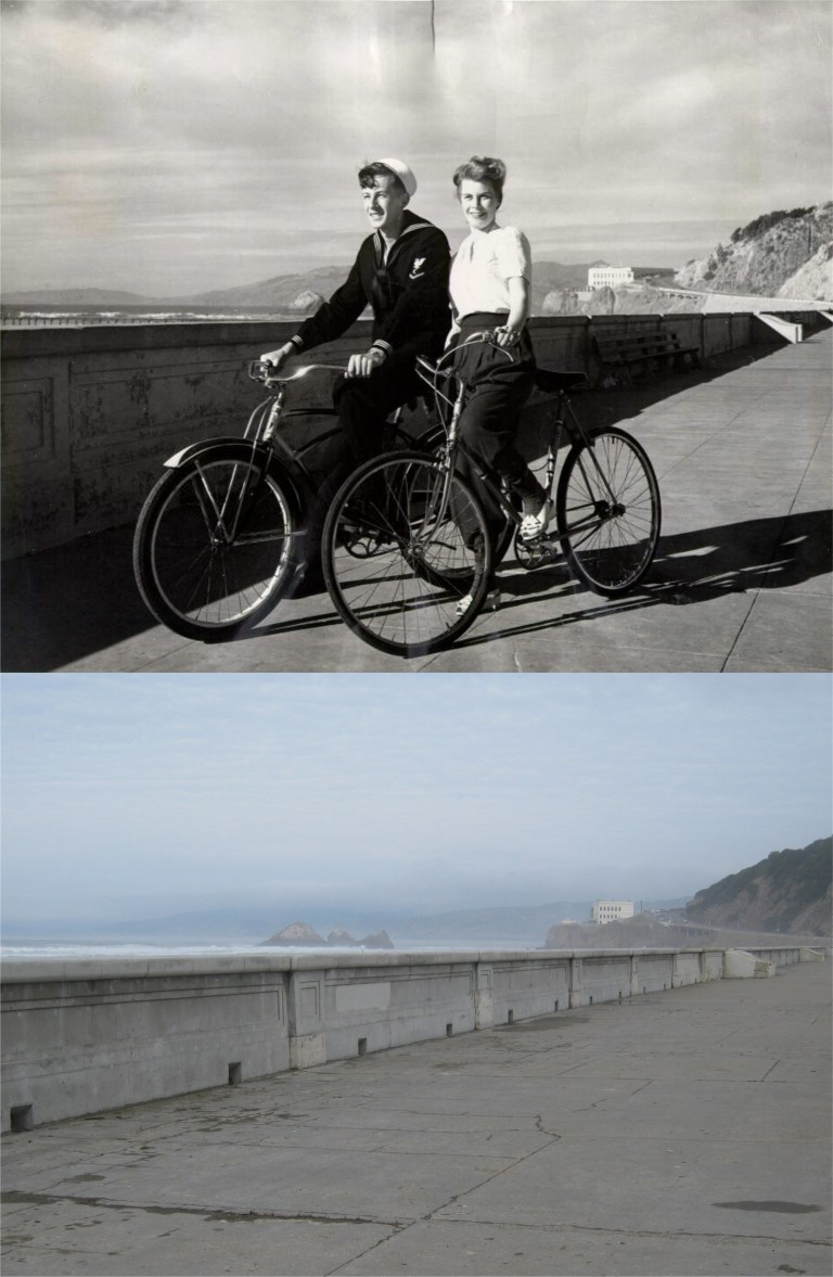 Hey, those are two-built-for-bicycles! They were riding along the sand barrier between Ocean Beach and the Great Highway in 1955 just down from the Cliff House.
 This picture is looking north down Fillmore Street from Broadway in 1903. It’s still a breathtaking view today. (Vintage photo, C. R. Collection)
 One of the historical essays on FoundSF.org is about a sit-down demonstration by military prisoners in the Presidio stockade during October of 1968 that became known as the “Presidio Mutiny”. After a suicide-by-armed-guard by one of the prisoners that was classified as being justified, twenty seven of the stockade prisoners participated in a peaceful demonstration outside of the stockade. FoundSF points out that many of the prisoners were misfits who should never have been in the army, but their treatment by the guards was undoubtedly brutal. Here, one of the prisoners reads a list of their demands. Behind him is the old Fort Winfield Scott, seen from the stockade today in my picture. (Vintage photos, Steve Rees)
 The vintage photo here is of the prisoners being given orders to end their demonstration. This is the spot where the “Presidio Mutiny” took place. Three things can be seen in both pictures; the stairs, the Golden Gate Bridge, and the stockade building on the right.
 In the end the prisoners were dragged back to the cells by other army soldiers. Some were given additional prison sentences ranging from six months to sixteen years. Over a year later their convictions were overturned and their sentences reduced to time served.
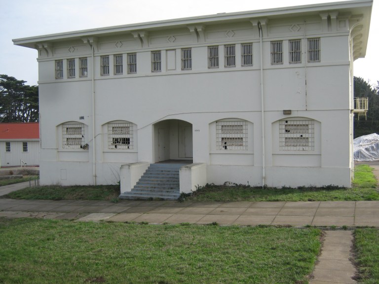 The Presidio stockade today, building 1213, empty and spooky to walk around:
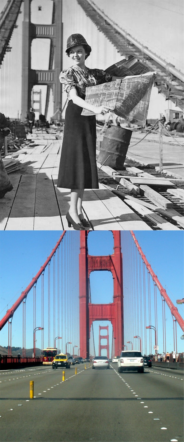 Actress Jane Wyatt pitches in on construction work for the Golden Gate Bridge in a publicity photo from 1937. She did a good job! (Pinterest)
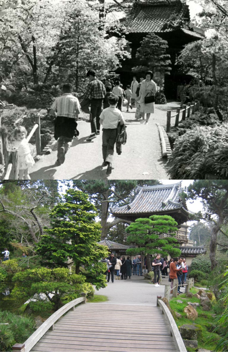 The main entrance to the Japanese Tea Garden from inside the attraction in March of 1966: (SF Gate, SF Chronicle)
 They still sail boats at Spreckles Lake in Golden Gate Park like they did in the 1930’s, but most of the boats aren’t as well crafted as those in a vintage picture from the Shorpy Collection.They’ve smoothed out the shoreline of the lake now, but I think it looked more natural before.
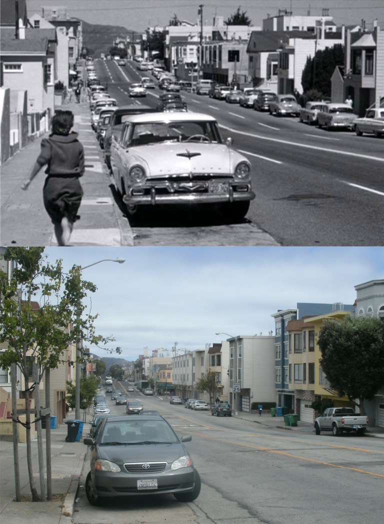 Stefanie Powers has fallen right into Ross Martin’s trap as she races down 25th Ave. toward Clement Street in the Richmond District in the 1962 thriller ‘Experiment in Terror’. Powers believes that her sister played by Lee Remick has been hurt. When she nears Clement Street Martin kidnaps her.
 Kim Novak taking a break during filming of the Fort Point attempted suicide scene from the 1958 film ‘Vertigo’. One used to be able to get to the exact spot where the scene with Kim Novak jumping into the Bay was, however, since 9/11 the Golden Gate National Recreation Area doesn’t let visitors get that close to the Golden Gate Bridge anymore. (Cinephiliabeyond.org)