
It’s a busy weekend in San Francisco, this one is. Today is the Bay to Breakers Race. This evening Kim Novak will be at the Castro Theater for a screening of Alfred Hitchcock’s 1958 film ‘Vertigo’ celebrating the 60th anniversary of its release. And yesterday was the Veterans Memorial Cruise aboard the SS Jeremiah O’Brien. The cruise honors veterans living and dead and a wreath laying ceremony is conducted on the voyage each year for some of the veterans lost. Once again I relied on http://opensfhistory.org/ for vintage pictures to compare with some of the photos that I took along the journey.
 There were a surprising number of World War Two veterans on hand and some interesting uniforms.
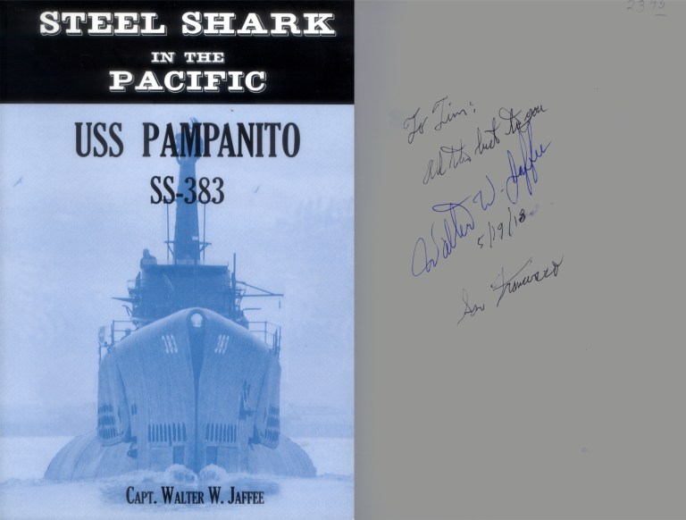 There were also a number of authors who have written books on military subjects autographing their books.
 We departed Pier 45 on a windy but beautiful day. This is Russian Hill in 1955. The street climbing the hill in the center of both pictures is Hyde Street.
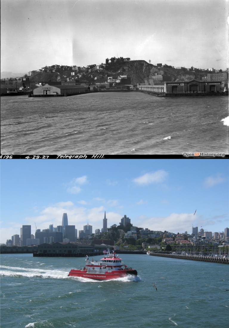 We sailed around Telegraph Hill, seen in 1927 without Coit Tower.
 We’re approaching the Ferry Building, seen in 1968. That’s the Bank of America Building going up in the old photo. There was no Hyatt Regency and no Embarcadero Center yet. The Bank of America Building, not the “king of the hill” anymore, can be seen on the right along with the Alcoa Building in my picture.
 We’re lined up with the Ferry Building at the foot of Market Street seen in 1906 with scaffolding around the tower to repair damage from the earthquake.
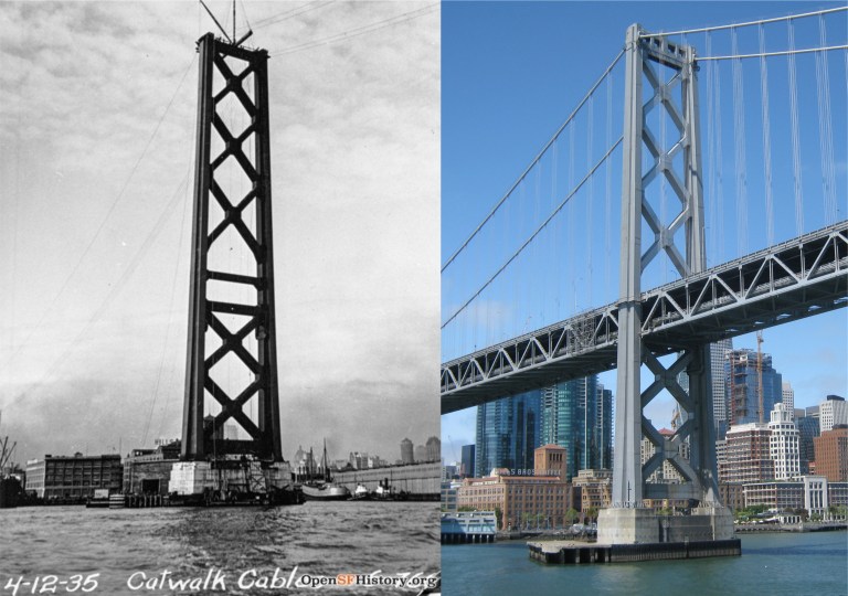 We’ve sailed under the Bay Bridge and you’re looking at the western most tower of the bridge being erected in the 1930’s. The old Hills Brothers Coffee Factory can be seen in both pictures.
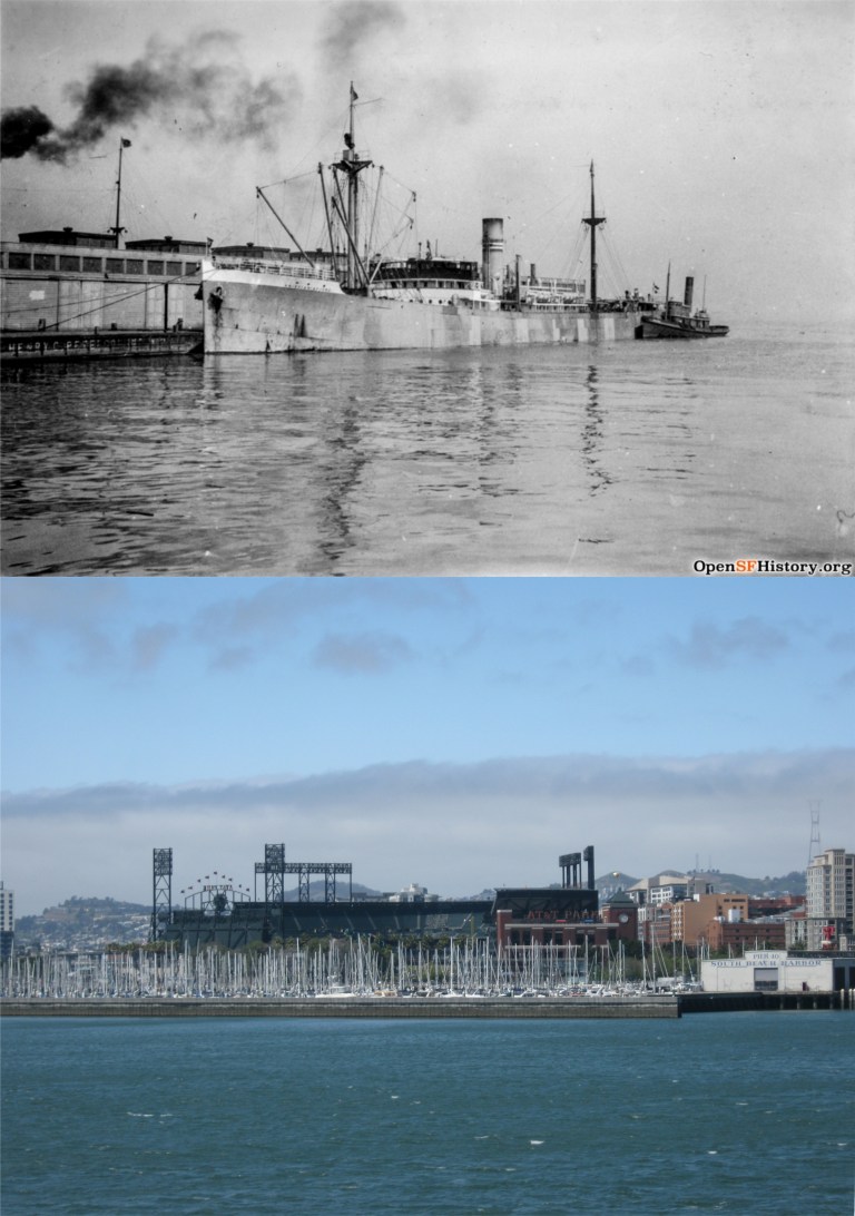 Now we’re at the China Basin, now called McCovey Cove after the San Francisco Giants slugger. The vintage picture is circa 1922. Just behind that ship is where AT&T Park is now. The baseball park was quiet and empty when we sailed past, but it was crowded and loud later in the evening when the Giants beat the Colorado Rockies 9 to 4.
 Now we’re cruising past Potrero Hill. The gas and water towers are gone now, but the smokestack from the old Potrero Generating Station is still there.
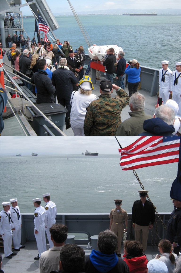 When we reached Hunters Point a moving wreath laying ceremony was held. I noticed that none of the ships or boats on our horizon were moving as well, so I wondered if they were respecting the ceremony also. However, an old salt on the Jeremiah O’Brien said that they were just waiting to be guided into port by a port harbor boat. I don’t know about that though, the little boat among them didn’t need guiding in!
 We headed back to town by a different and interesting route. It was time to relax, like these ladies on a ferry boat were doing in 1954, and enjoy some of the free coffee, donuts, hot dogs, and beer.
 Our return trip took us under the new Eastern Span of the Bay Bridge that replaced the old cantilever span, seen in 1960 in the vintage picture. The Eastern Span opened in 2013.
 And under the bridge we went! That’s the first time I, and probably most of the people on board the Jeremiah O’Brien, had ever done that.
 So, we headed back to Fisherman’s Wharf, guided in by tug boats. That’s the old sailing ship Balclutha that used to be docked at Pier 43 in the 1964 picture. There was no Bank of America Building, Transamerica Pyramid, or Salesforce Tower back then, and two of the more cherished buildings in the old photo, Coit Tower and Saints Peter and Paul Church, can still be seen.
 Looking down California Street between Powell and Mason Streets in the 1970s; no stoplights back then, and they don’t advertise Jim Beam Whiskey on cable cars anymore. The parking sign was where the old Crest Garage, then called the Rolls Garage, was located. It was demolished in February, 2018. (Vintage pictures from the photo researchers of Minerva S.A., 1977)
 Powell and California Streets: I had a nice line up on this one, I wish it had been a clearer day.
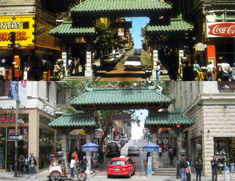 Ah, the entrance to the mystic world of Chinatown! You know that you’re in an exotic location when the signs read ‘Country Burger’ and ‘Coca Cola’ at the entrance.
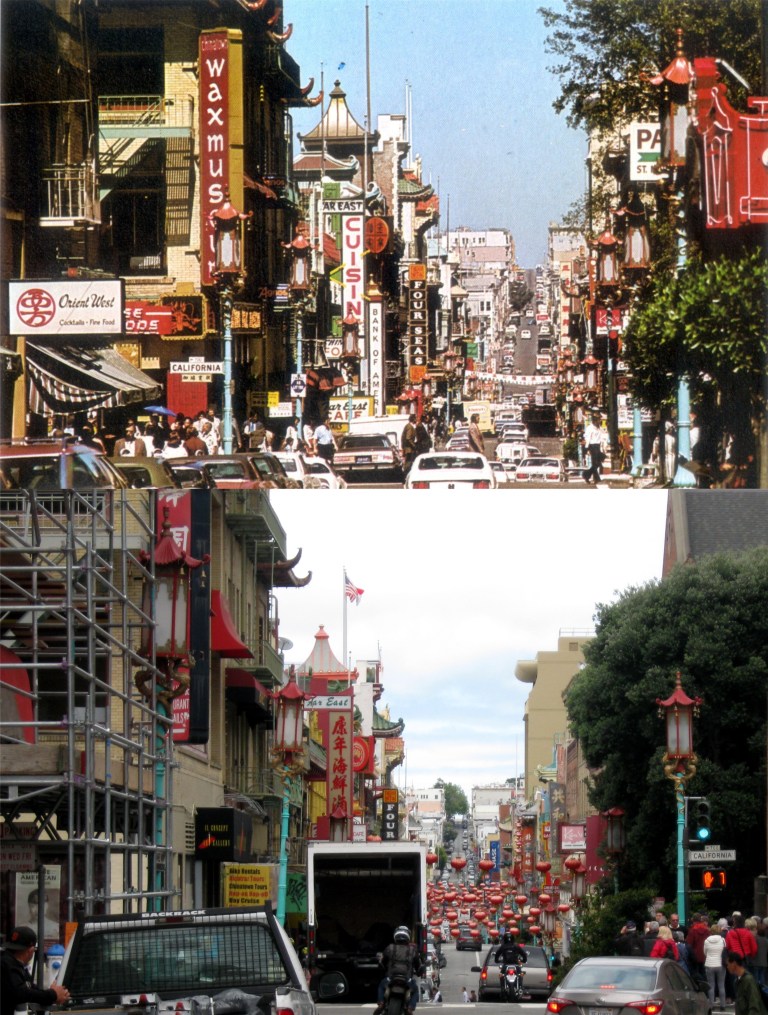 “Sign, sign, everywhere a sign”: There are still a lot of signs in Chinatown today, but they’re not “breakin’ my mind” like in that old 70’s song, and the red lanterns of nowadays are an added improvement.
 The old Crocker Bank on the corner of Montgomery and Post Streets: This was the bank where Lee Remick’s character Kelly Sherwood worked in the 1962 film, ‘Experiment in Terror’. Crocker Bank is defunct now and the top floors of the building were removed at the end of the 1970’s for a rooftop park.
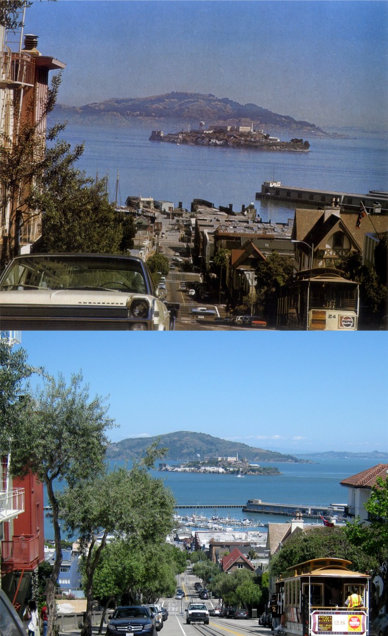 It was a lot prettier of a day in San Francisco today when I finished this set than it was a few days ago. In fact, it was about the nicest spring day I’ve had in town so far. I was trying to figure out why Alcatraz Island seems to tilt so much in the older picture looking down Hyde Street after you pass Chestnut Street. Of course, it’s partly due to the photographer, but it actually does seem to slant as you move further down from Chestnut. Probably because Hyde doesn’t run directly toward Alcatraz. Or maybe Alcatraz does tilt occasionally and no one has ever been able to figure out why.
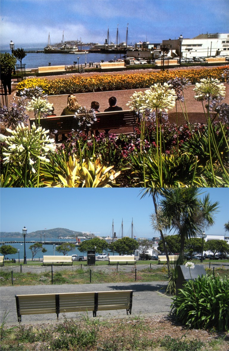 They used to call this peaceful portion of Aquatic Park on Beach Street Victorian Park, but I don’t know if anybody calls it that anymore.
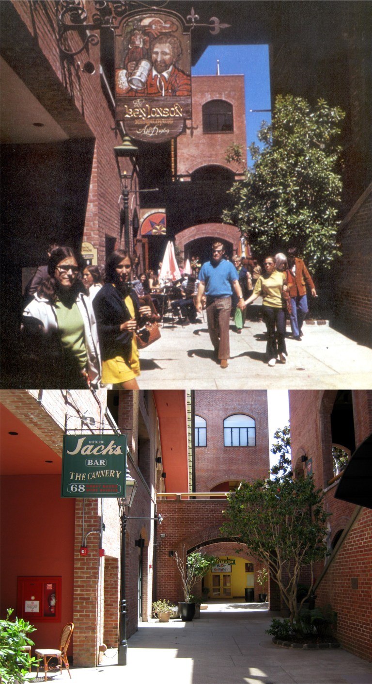 The Ben Jonson Restaurant in the old Del Monte Cannery Building near Fisherman’s Wharf was very popular in the 1970s. They served mostly recipes from England, but I’ll bet they didn’t serve Yorkshire pudding!
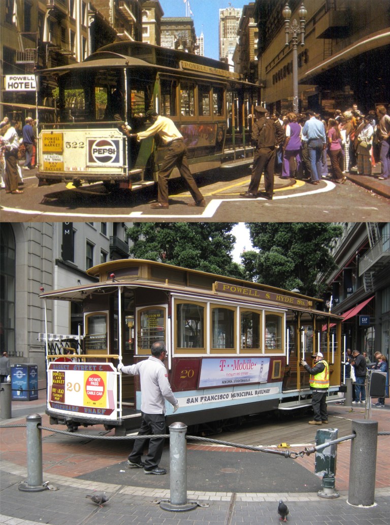 If I have critics, and nobody’s worth much if they don’t, “Woe unto you, when all men shall speak well of you”, they’ll probably say, “He’s always posting pictures of the same spots.” There’s truth in this, but I always feel that the website isn’t about my pictures; they’re, at best, pleasant snapshots. However, the vintage pictures are what it’s all about. I’ve probably posted dozens of pictures at the Powell and Market Streets cable car turnaround, but I keep discovering new pictures from the past of this location and these are what make a then and now comparison fun to look at. In short, sometimes when I post these pictures, “this I do for me.” The long cable car lines of today hadn’t really started forming yet back then and, surprisingly, the line a couple of days ago when I took the current picture was smaller than they were in the 1970’s!
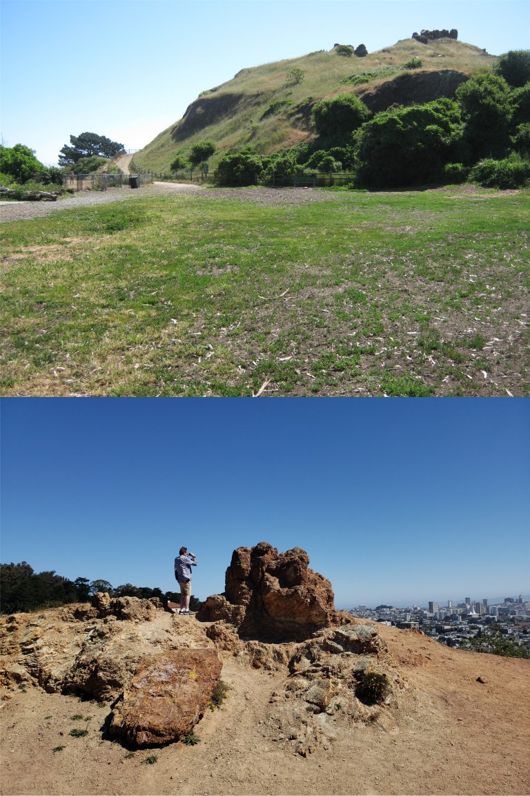 I visited Corona Heights for the first time ever: I can’t believe that all these years I’ve never been up there!
 The views of San Francisco from the top are as stunning today as they were in the 1960’s. (Michael Bry)
 Also on Corona Heights is the Randall Museum of Science, Nature and the Arts and its many wildlife exhibits. But seriously, this is a very interesting museum well worth visiting.
 Drove over to the Fillmore Street Hill at Vallejo: How did people drive their cars up here before automatic transmissions were invented? (Curbed San Francisco)
 Back to familiar ground: My mom got to San Francisco long before I did, and as a pre-World War Two teenager from Grand Forks, North Dakota, one of the first places she wanted to visit was the Cliff House. The vintage image is from the 1950’s. (virginiapicks)
 Before they closed it off, I had a chance to locate the spot where my mom, on the left with her cousin Frances, was sitting on the old stone W.P.A entrance to Fleishhacker Zoo.
 They’ve fenced the old entrance off now, either to keep people from sneaking into the zoo, or animals from sneaking out.
 Some, someday moms at the old Fleishhacker Pool: The girls in the picture from the Shorpy Archives are posing in 1927, two years after the pool opened. I’m standing on top of the pool in the current picture; the pool was filled in and is buried under the San Francisco Zoo parking lot. That’s the entrance to the old pool house on the left in the modern picture, the only thing remaining of Fleishhacker Pool.
 That’s my 17 year old mom on the left swimming in Fleishhacker Pool on her first visit to San Francisco. If she looks miserable it’s probably because the water in the pool was rumored to always be cold!
 Jackson Street is the northernmost extent of the Powell Street cable car line. From here the cars turn west to go to Mason or Hyde Streets. The vintage picture is the turn in 1914. (SFMTA archives)
 From Jackson Street it’s a gradual and relatively easy walk up hill to California Street. From here Powell St. drops down Nob Hill to Market Street. This picture from the early 1960s shows the north view that the tall Sir Francis Drake Hotel in the center used to have. (Vintage Everyday)
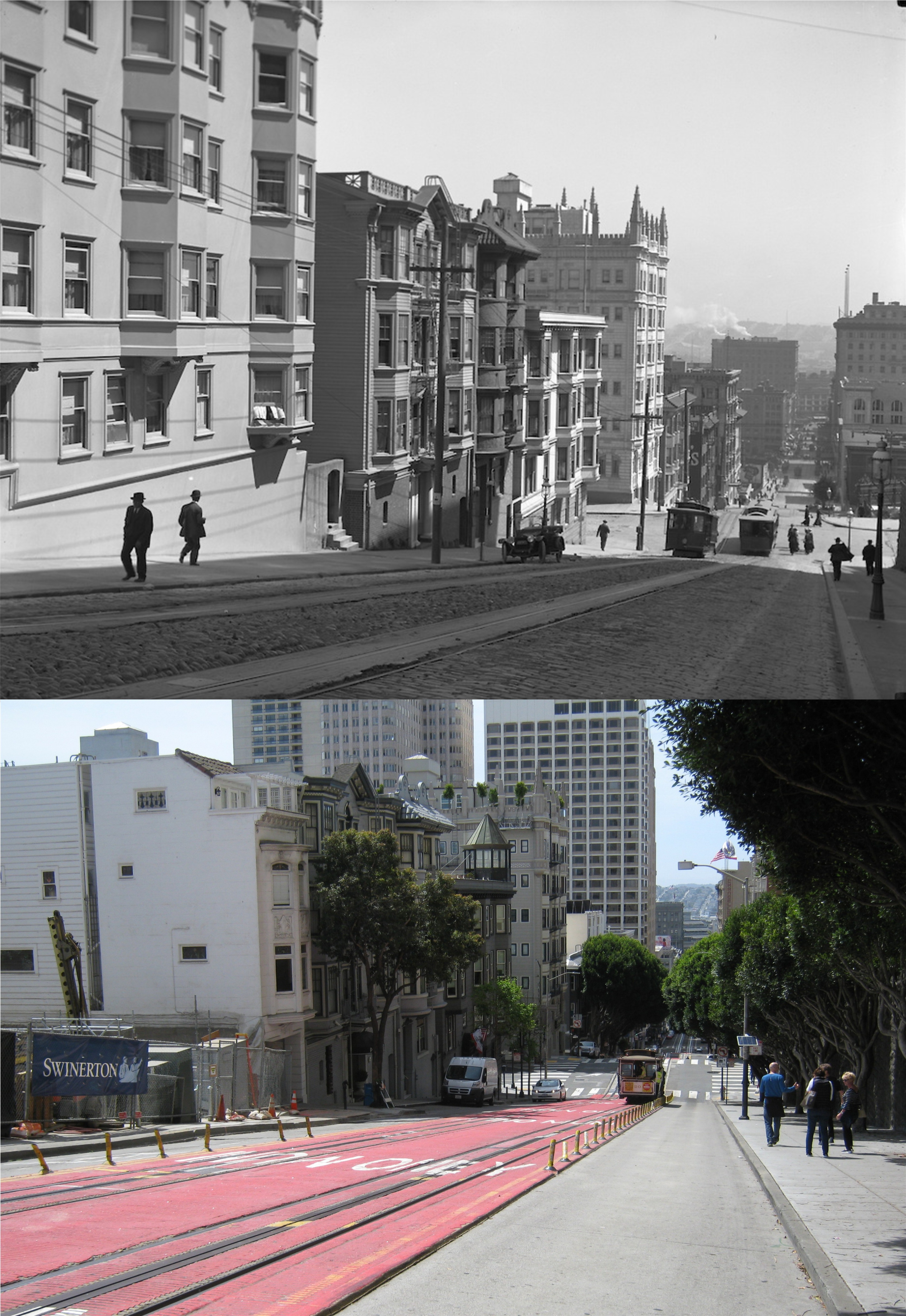 This great view from the 1920s shows Powell Street as it drops toward Pine Street before the Sir Francis Drake and the Hilton Hotel, in the center of the modern picture, were built. (SFMTA archives)
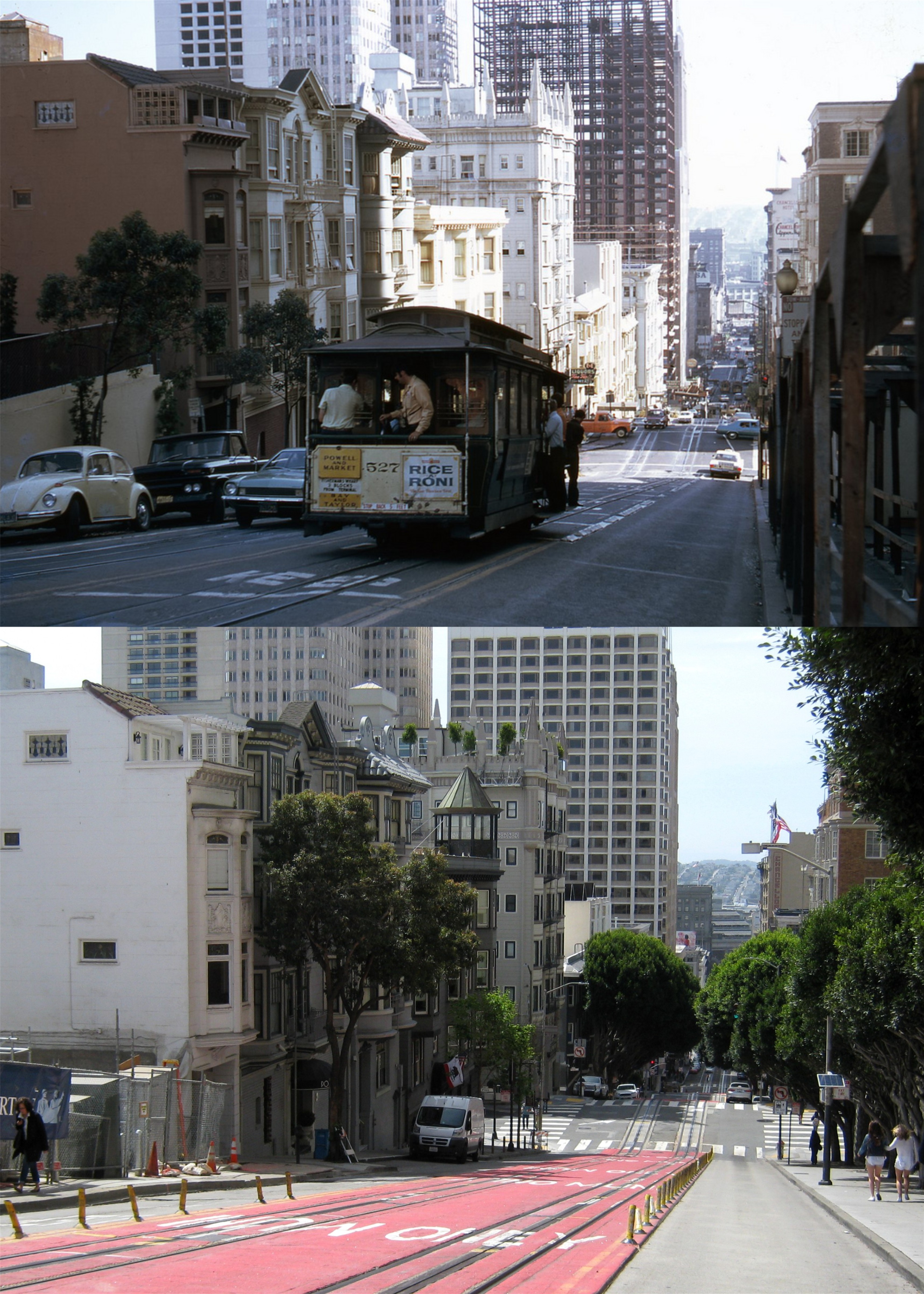 As we move closer to Pine Street in the early 70s you can see the construction in progress of the building that would forever block the north view that the Sir Francis Drake Hotel with its legendary Starlight Room on top had. (Lindsaybridge)
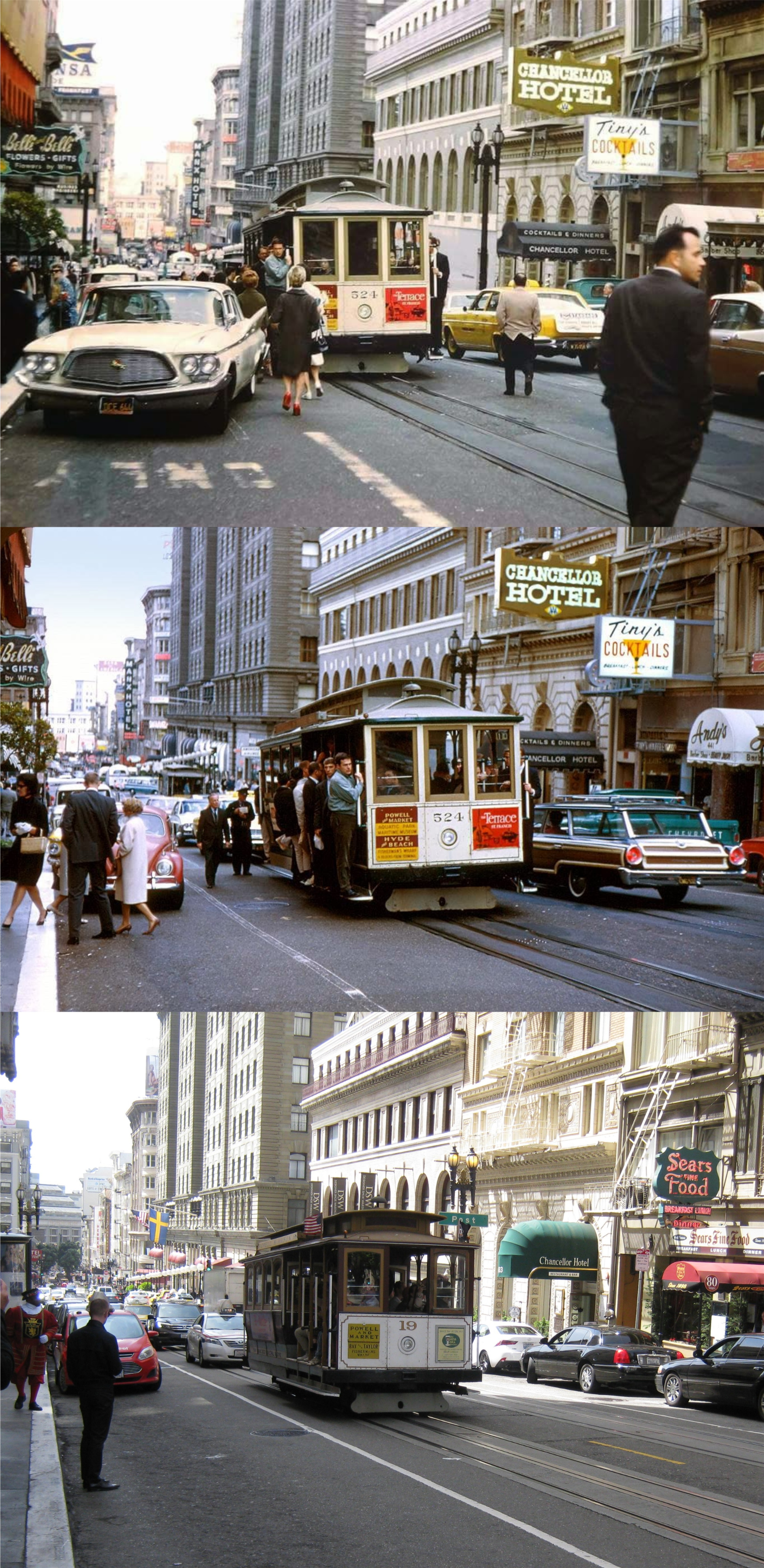 I’m past the Sir Francis Drake Hotel now and heading toward Post Street and the St. Francis Hotel. (Vintage Everyday)
 Cable cars were easier to catch in 1917 on Powell Street looking north toward Ellis than they are today. Now they rack them up all the way back from Market Street for the riders. (SFMTA archives)
 I finished my walk at the Powell Street turntable at Market Street; it looks like a World War Two era picture in the vintage photo. That was a nice spring walk! I felt like turning around and heading back, but Powell Street is a lot more of a climb from this direction. Spring makes me lazy and I wasn’t in the mood for that much exercise.
 In 1957 Doubleday and Company published Herb Caen’s guide to San Francisco, aptly titled ‘Herb Caen’s San Francisco’. Very imaginative! It’s deliciously outdated and fun to read with entries like “STEINHART AQUARIUM, open 10 A.M. to 5 P.M. daily, no admission charge. Easily the most popular attraction in the park, the aquarium draws as many as ten thousand visitors a day, all walking around openmouthed in the semidarkness to stare at the openmouthed fish.” John Steinbeck once wrote, “It is very probable that Herb’s city is the one that will be remembered.” However, what interests me most about the book is the map on the inside of the front cover and first page. There is no explanation in the book as to why the route was laid out. In some areas it’s similar to the famous 49 Mile Scenic Drive, although shorter. Oddly, it bypasses some of San Francisco most visited tourist attractions, such as the Golden Gate Bridge, the Cliff House, Twin Peaks, Mission Dolores, and Union Square. The trail starts on Mason Street and ends on Mason Street. I followed the mysterious route over last weekend doing then and nows of photos along the way from OpenSFHistory.org. The OpenSFHistory.org site has one of the best, if not THE best, collection of vintage San Francisco pictures to be found. So let’s get our exercise and follow along on Herb Caen’s 1957 map from Mason Street to Mason Street.
 We’re off! We’ll start on the west side of the Mark Hopkins Hotel with these two dapper gentlemen from 1958.
 The trail heads down California Street turning north onto Grant Avenue. We’re in 1943 now with these ladies and next to Old St Mary’s Church.
 We move past Commercial Street in the 1930’s. Commercial is one of two streets that leads straight to the Ferry Building, the other being Market Street; although, Commercial Street is cut off from reaching the Ferry Building now by the Embarcadero Center.
 The route leaves Chinatown and heads northwest along Columbus Avenue. We’ve come forward a little in time to 1971 here at Columbus and Union Street. The 39 Bus is crossing Columbus Ave along Union and heading up to Coit Tower. The 39 line still passes by here and I wanted to get a picture of a coach going by in my photo, but the street is closed off now due to a massive fire that destroyed the building on the southwest corner of the intersection several weeks ago.
 This is what’s left of the building now.
 Like the 49 Mile Drive, the route heads up Lombard to Coit Tower, seen here in 1962 where Greenwich Street that runs next to Lombard ends. Hey, it’s going to be a long trip, so, I didn’t feel like going all the way to the top, okay?
 The trail passes by the Fisherman’s Wharf boat lagoon on Jefferson Street, seen here in 1936. Oh, swell, it’s Mrs. Danvers! (cf. ‘Rebecca’) “Now, sit right back and you’ll hear a tale, a tale of a fateful trip” Don’t worry, that’s the ‘Lovely Martha’ not the ‘Minnow’. I’ve been out in the Bay on that boat. The building with CONSOLIDATED on it was demolished and was to the right of the little brown chapel in the background.
 After leaving Fisherman’s Wharf the map moves over to Bay Street and takes a strange diversion from the 49 Mile Drive and runs south along almost the entire length of Van Ness Avenue to Fell Street. We’re watching President Franklin D. Roosevelt’s motorcade, here on Van Ness near Bay Street, pass by in 1938. Fort Mason is in the background.
 At the other end of Van Ness, we’ll turn onto Fell Street. This is Van Ness at Fell after the 1906 Earthquake and Fire. The crumpled City Hall Building is in the background.
 We’re heading west on Fell Street, the street that many people take to get to Golden Gate Park. The 49 Mile Drive does not move along any portion of Fell Street. This view is looking east down Fell from Fillmore Street in 1939.
 The trail enters Golden Gate Park where we’ll stop and rest at McLaren Lodge like they did here in 1905. Superintendent John McLaren, the mastermind behind Golden Gate Park, lived here for forty seven years.
 The route crosses through the park and exits near where Playland-at-the-Beach used to be, and was when the map was drawn. If we were in 1941 at Fulton Street and La Playa, like the vintage photo, we’d be looking at a terrific roller-coaster instead of these condominiums here today.
 Now we’re back neck to neck with the 49 Mile Drive in a race south down the Great Highway. We’ll stop here at Ocean Beach near Kirkham in 1916 to look at the sad wreck of the Aberdeen on the beach. High winds caused the ship to capsize and wash ashore here taking all eight of her crew down with her.
 Let’s move down the Great Highway to Taraval Street and look back up north three years later in 1919.
 We’ll turn east on Sloat Blvd. and stop for awhile as they move an old train into Fleishhacker Zoo, now the San Francisco Zoo, at the old stone Works Progress Administration entrance in 1957. Hmmm, I’m suddenly hungry for a Doggie Diner hamburger.
 Now, we’ll move on to Portola Drive and bypass Twin Peaks like Herb Caen’s map did. Hey, I love the view up there but there’s no parking! The old photo is Portola Drive at Twin Peaks Blvd. in 1929. You can see part of the old road that headed up to the top of Twin Peaks on the left.
 Sneaking past Twin Peaks and dropping down a few notches will put us on Market Street heading toward Downtown San Francisco. Here we are at Market Street and Duboce Avenue in 1945 near the new, old U.S. Mint. We’re looking back toward Twin Peaks.
 We’ve moved to the beginning of Market Street, or, if you were heading in our direction, the end of Market Street. It’s probably a sin for any respectable tour route to leave the Ferry Building out and this 1957 one doesn’t. We’re back in 1962 again, and this is where California Street meets Market. You can see the cable car tracks in the old picture, but not much activity.
 We’re in the home stretch now and heading along Pacific Avenue, the heart of the old Barbary Coast. This is the old Engine #1 Fire Station Building seen here in 1917 and still there today.
 Well, we’re back on Mason Street at Pacific Avenue in 1960 and looking up Nob Hill to where we started from. I don’t know about you, but I’m tired! I’m not walking up that hill! I’ll take the cable car.
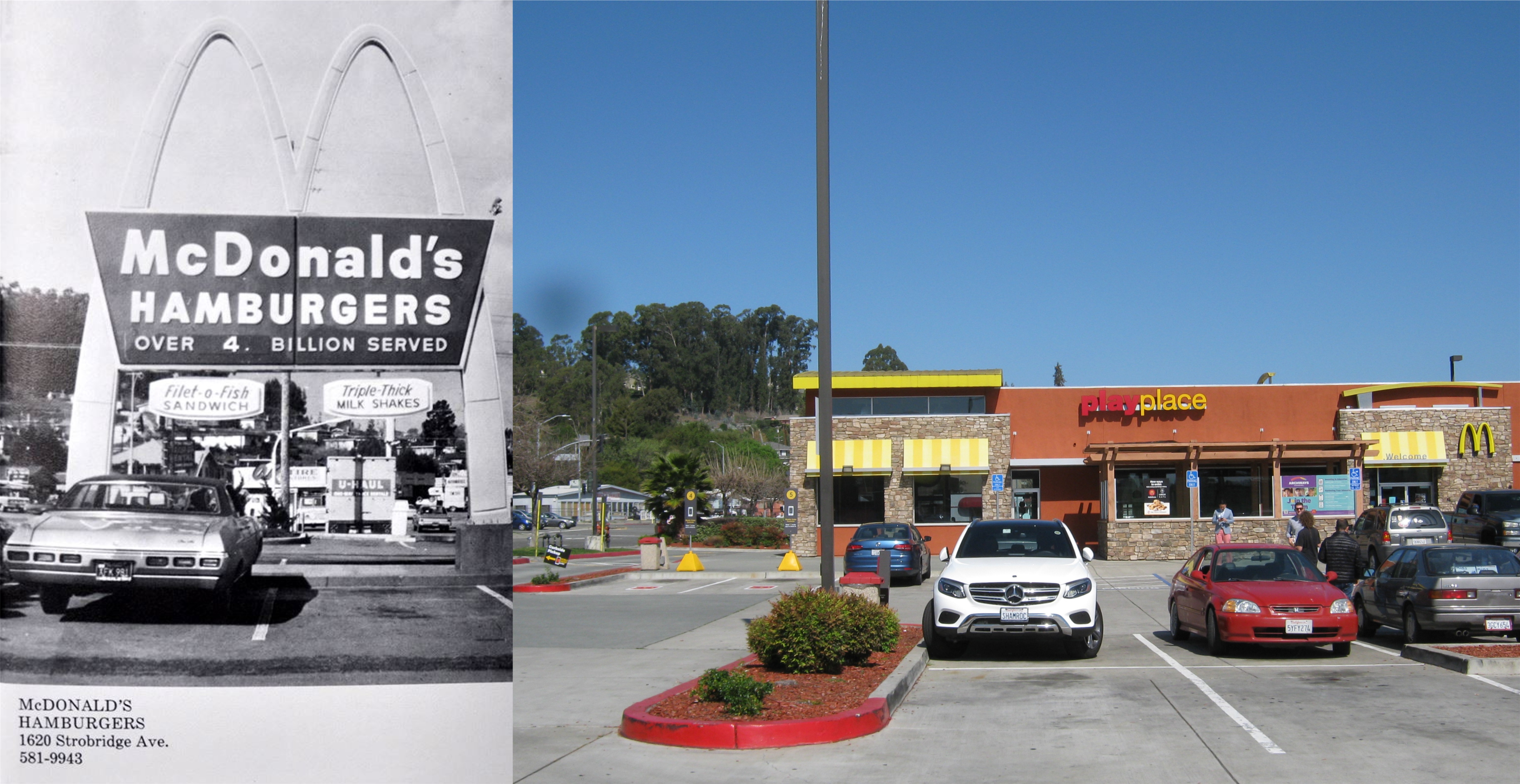 On the western side of Castro Valley Blvd. is the McDonald’s, opened in the 1960’s and still there today, although, the original “Golden Arches” are long gone.
 What you’re looking at here was about all there was to Castro Valley Blvd. in the 1930’s; the section between Lake Chabot Road and Stanton Avenue. Some of the buildings in the old photo are still there.
 Opened in 1949, the Chabot Theater is still drawing them in today. Watching a film here is like stepping back in time. I sat through a lot of double features here as a kid, when such a novelty existed.
 Across the street from Chabot Theater was one of our hangouts in the 70’s, Jenna’s Pizzeria. They had a room with pool tables and a small bar in back of the dining room, and a pretty girl named Sue who made sure your beer pitcher was never empty.
 The southeast corner of Castro Valley Blvd. and San Miguel: No, this isn’t a scene from ‘That 70’s Show’.
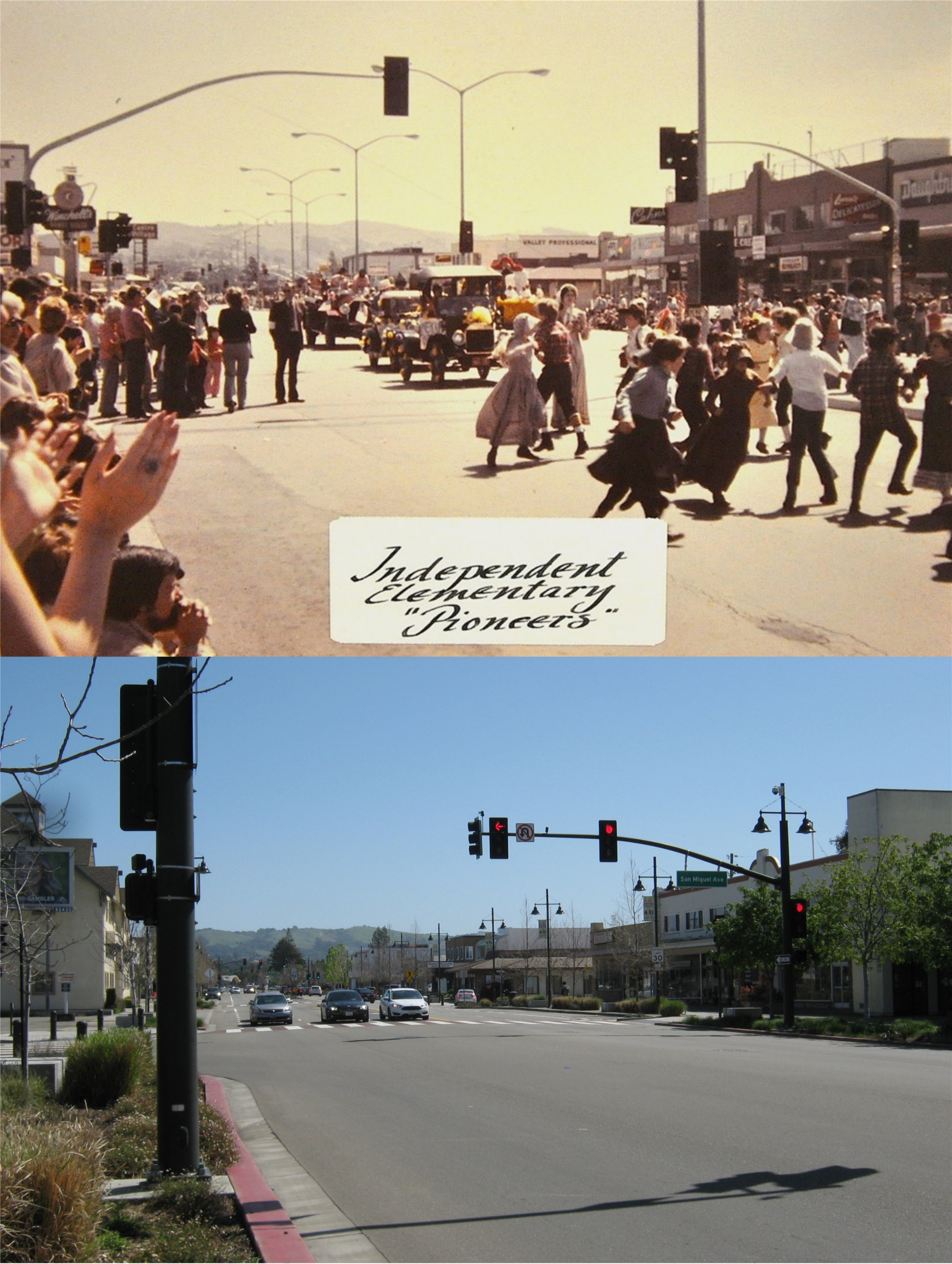 Directly kitty-corner from the previous picture on the northwest corner of the intersection is this view of a 1976 Bicentennial celebration. On the far left was Winchell’s Donuts, THE place for coffee and donuts in Castro Valley for many years.
 Another sad memory when walking along the Blvd. today is the old Daughtrey’s Department Store; closed in the early 1990’s. Across the street at center is the Castro Village, opened in 1948 and a world in itself.
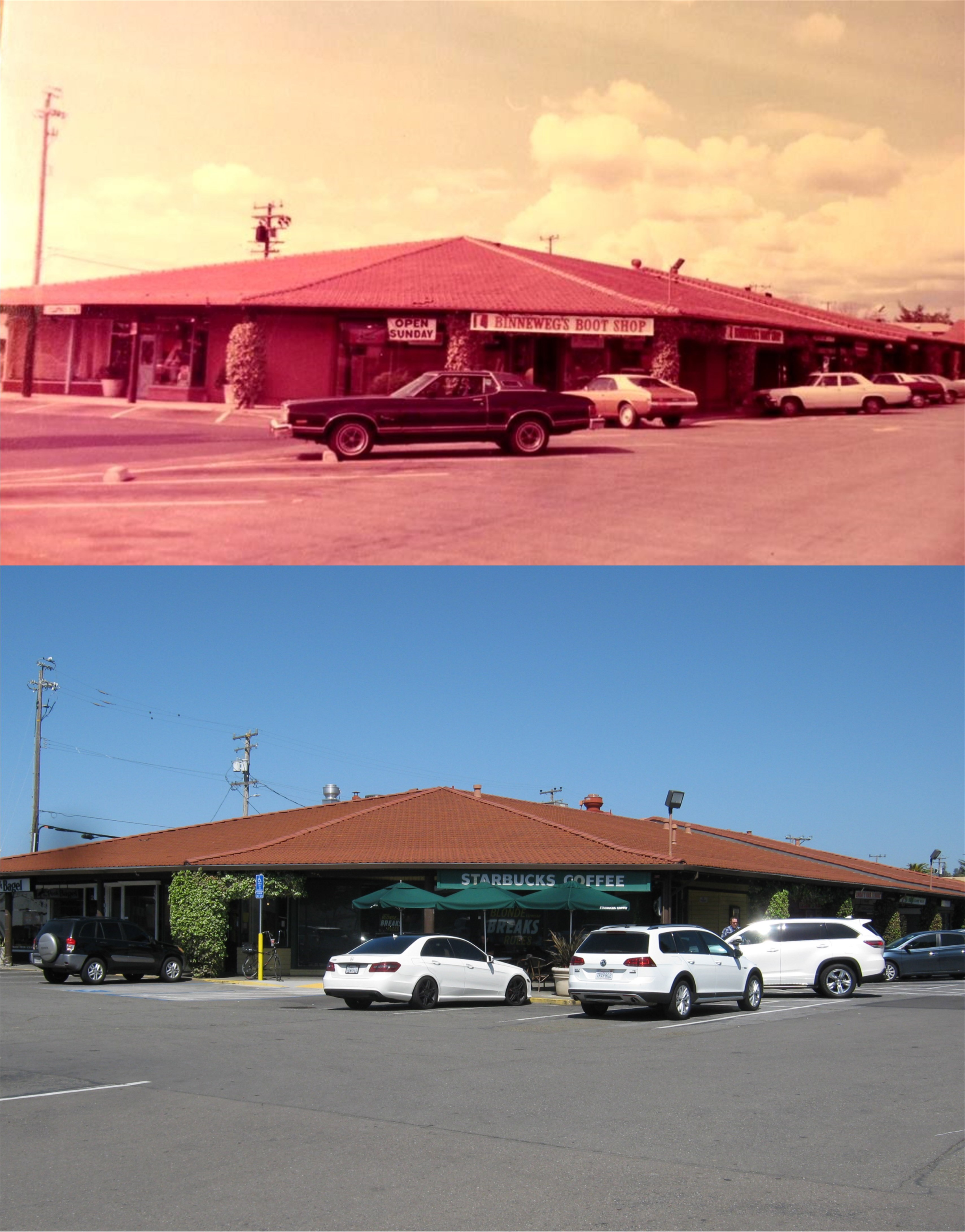 And, of course, Castro Village; designed with the look of an Alpine village, which new developers are sadly getting rid of as much as they can. The toy shop, variety store, and ice cream parlor were “the stuff that dreams are made of” when we were kids. This view is the corner of the Village at Santa Maria and Castro Valley Blvd in the 1970’s and today.
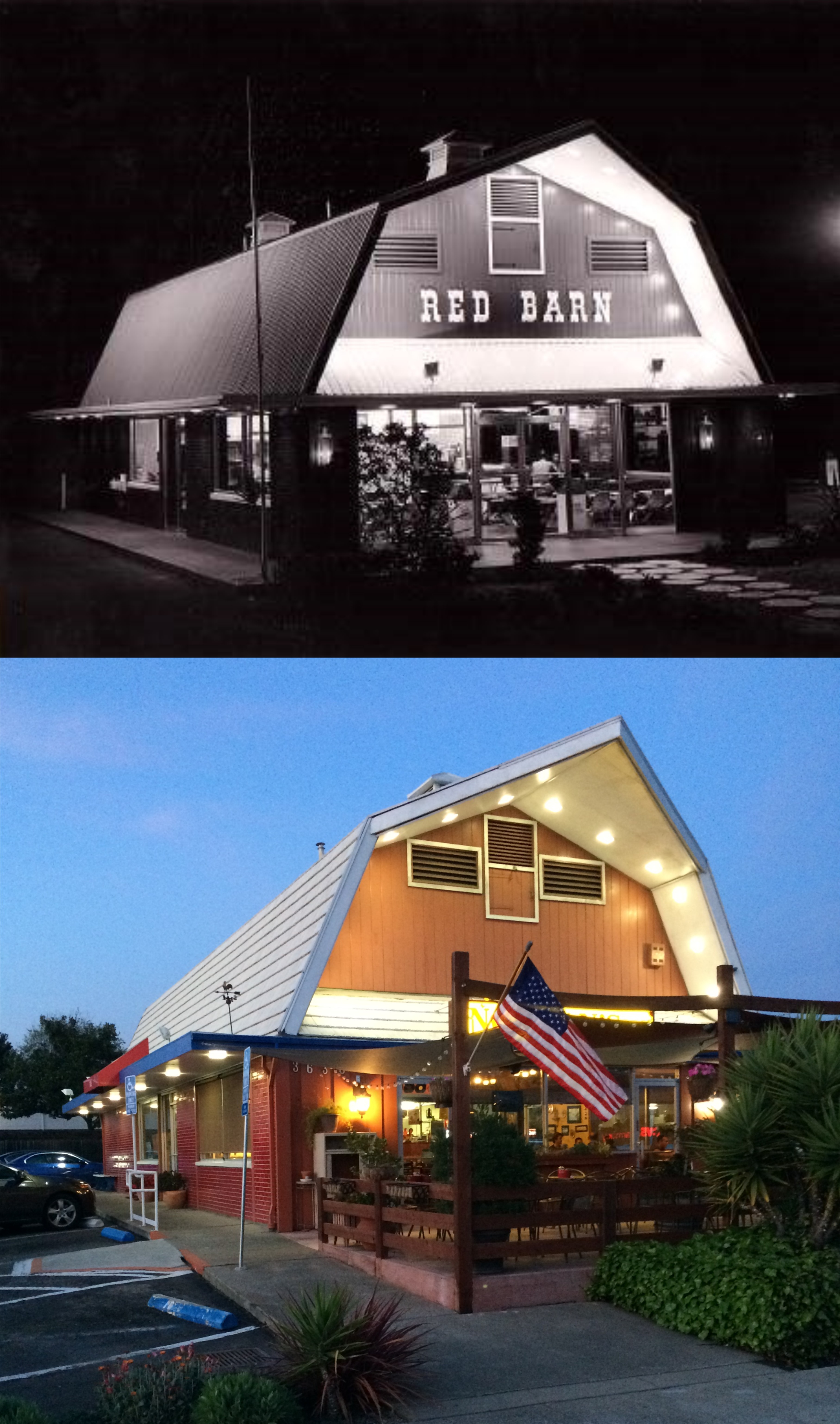 Ah, the old Red Barn Restaurant, our hangout when I was a junior in high school. We usually never had enough money for more than a a coke and a bag of French fries, but we’d sit there for hours and nobody working there minded. It’s now called Norman’s Restaurant.
 We’ll end up on the eastern side of the Boulevard and another wonderful memory for me. This building opened up as Value World. They had everything there; a sporting goods section, a snack bar, a grocery store, anything you could want! I remember spending nearly an entire day in the 8th grade walking around Value World with a girl that I had a crush on named Cindy. I’m sure I spent all of my money on her, but I probably didn’t have more than a dollar anyway! It’s now a Rite Aid, and I still think about that day and Cindy every time I go in there.
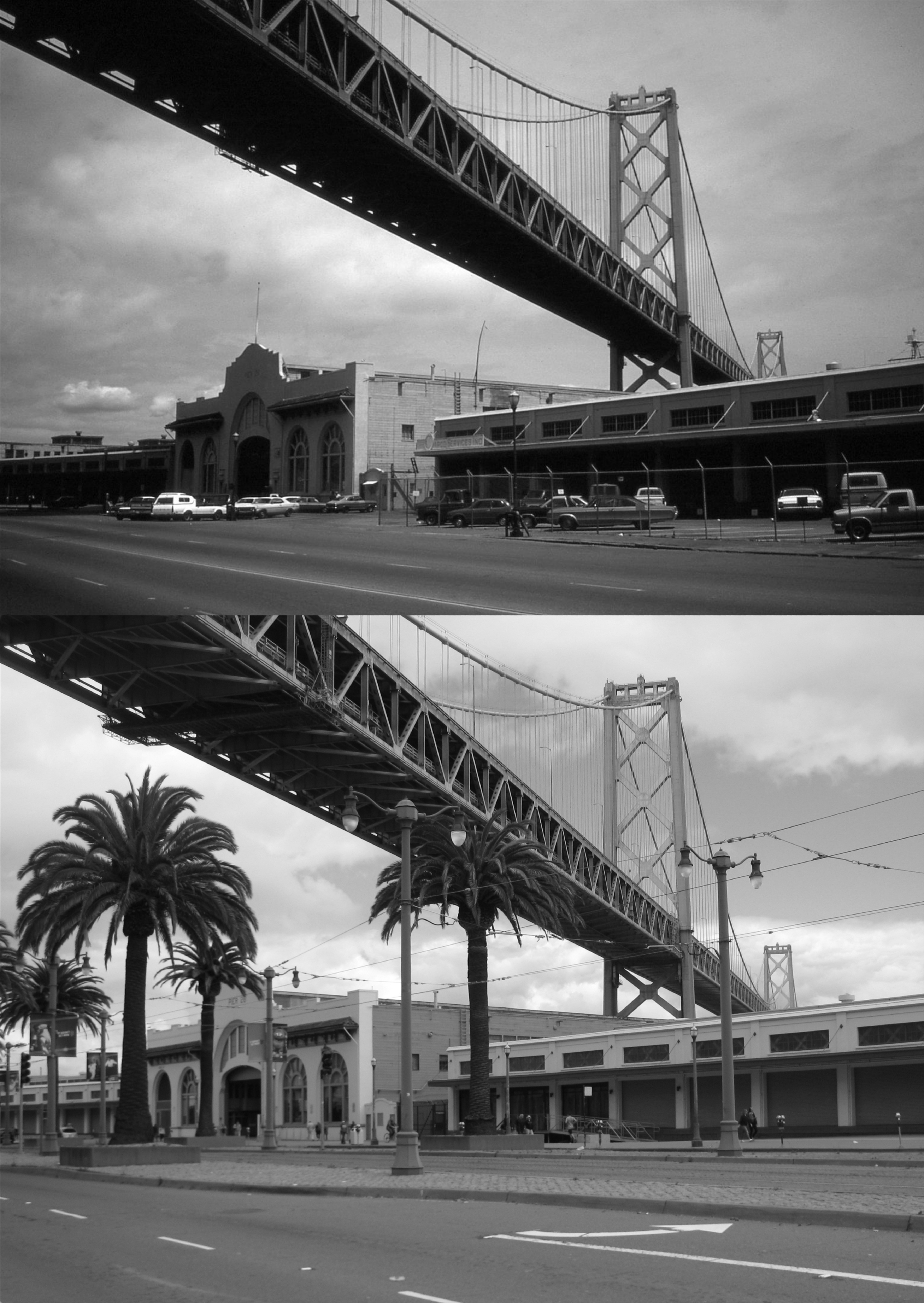 We’ll start at the Bay Bridge and end up on Twin Peaks. This slide is from 1983. AT&T Park and the San Francisco Giants turned this run down area into one of the most popular places in the City. In fact, people were already heading out to park this morning to watch the Giants play the Los Angeles Dodgers when I took the contemporary picture. The Giants won 4 to 2!
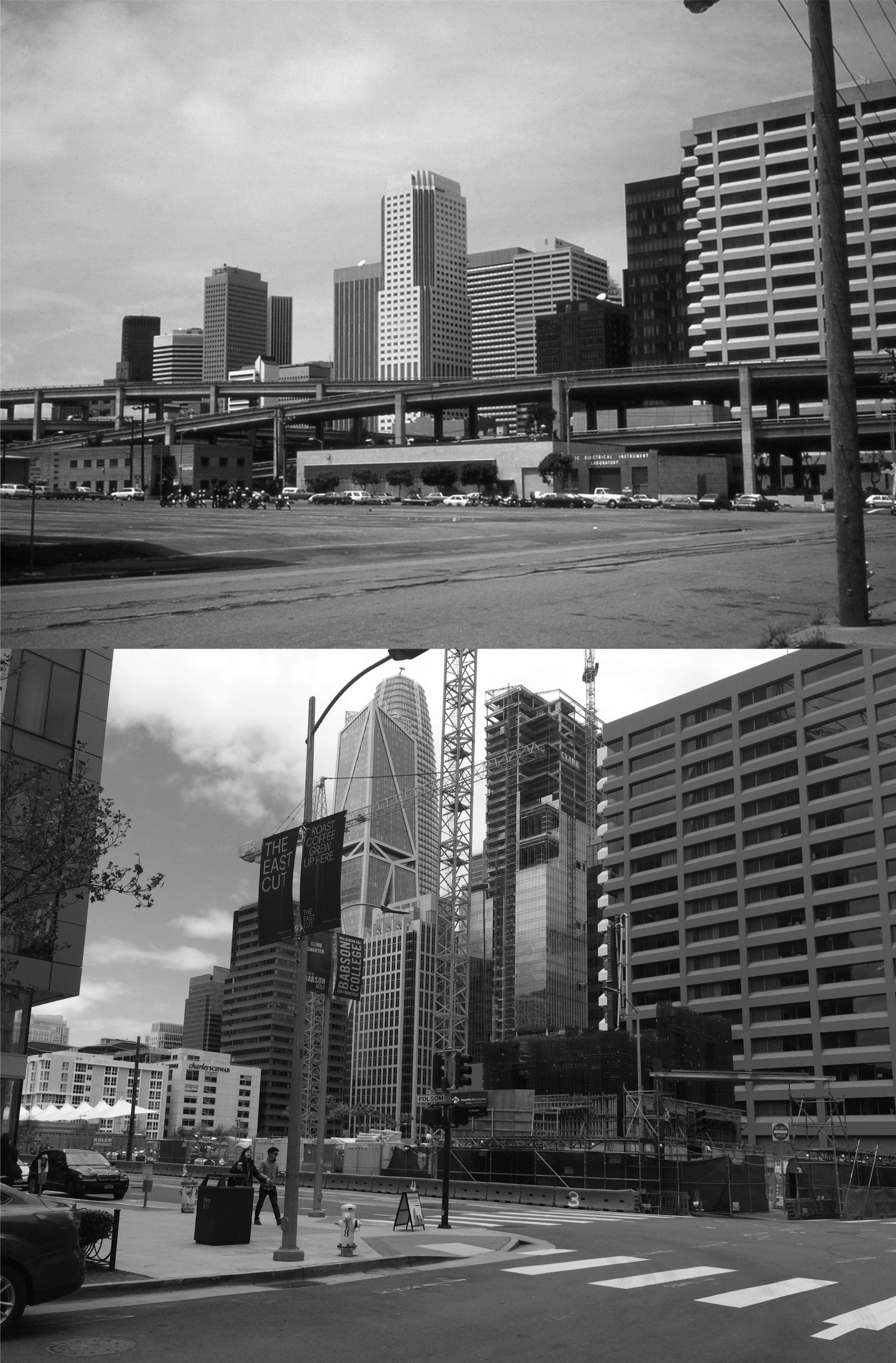 I’m not positive where I took this 1983 picture of the South of Market area, but it was probably on Spear Street between Harrison and Folsom. The pile drivers have long since conquered this area so I had to move down to Folsom to get a reasonable comparison. The white building in the center of the vintage picture is on the corner of Fremont and Mission Streets. This building is to the right of the enormous Sales Force Building in the center of today’s shot and blocked by other buildings now. That’s the Fmbarcadero Freeway stretching across my 1983 picture.
 Market Street at New Montgomery with the Palace Hotel on the right: I think I took this one in 1985. The tall Building in the background of both pictures is the old Pacific Bell Building, for many years the tallest building south of Market street.
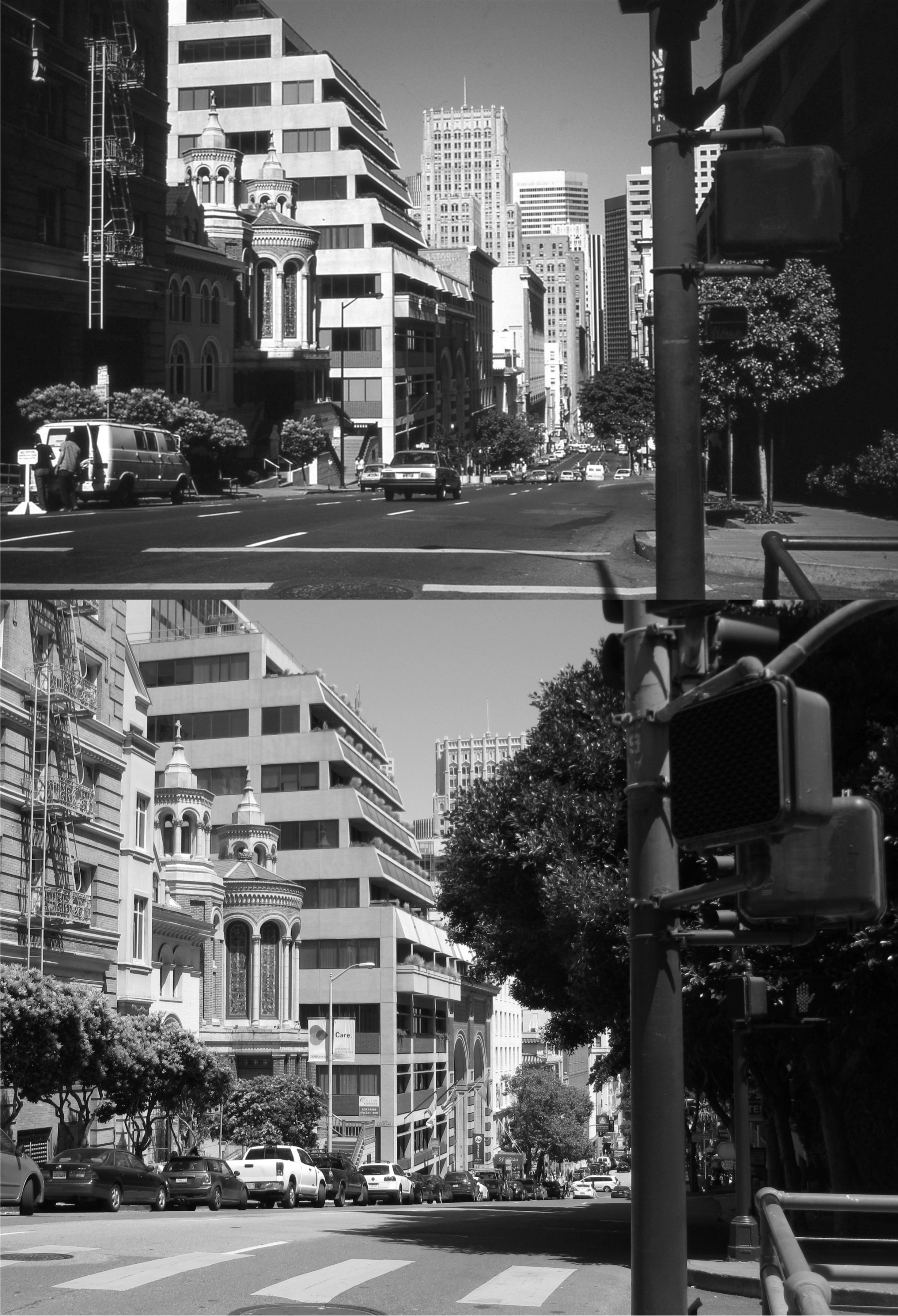 This is at Bush Street above the Stockton Tunnel looking down toward the Financial District in 1985. The tall building in the center is the Russ Building on Montgomery Street. Just a few yards behind where we’re looking is Burritt Alley where Brigid O’Shaughnessy shot Sam Spade’s partner Miles Archer in ‘The Maltese Falcon’.
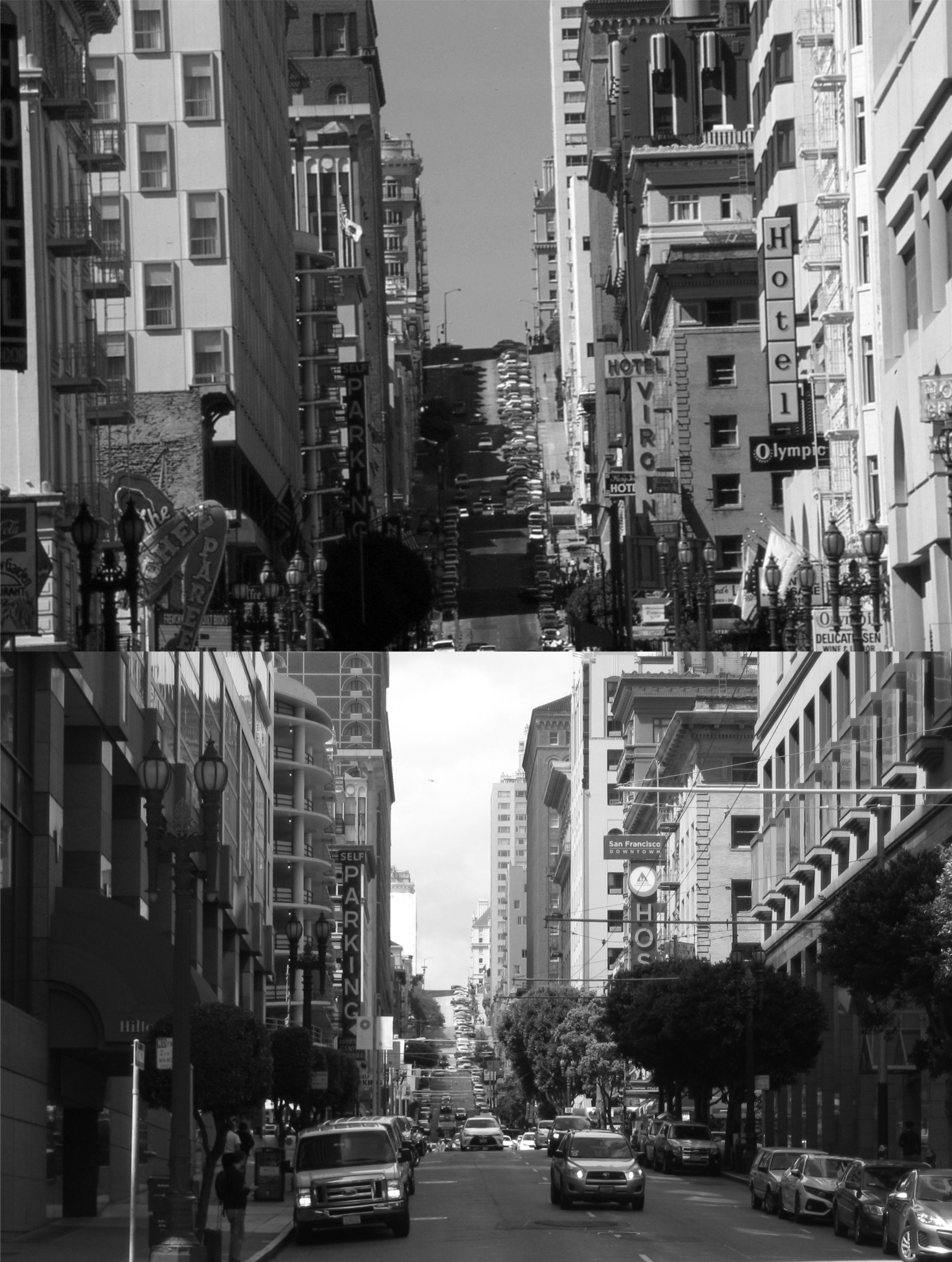 This is a zoom in shot up Mason Street and Nob Hill near Ellis in 1985. This used to be a pretty bawdy section of town; I’m surprised I didn’t take more pictures in this area back then! My digital camera doesn’t zoom is as well as my trusty 1980’s Canon Camera did, (I still have it) but I gave it a try. That’s the parking garage on the corner of Mason and O’Farrell on the left.
 Market Street west of 10th in 1985: The old Seals Stadium sign on the streetcar gives the vintage picture a nice touch. Gawd, I’m referring to the 80’s as vintage! This was around the time they started running old streetcars along Market Street.
 This 1985 slide that I took from Twin Peaks matched up pretty good with a 1960’s picture taken by Michael Bry.
 These scenes are from the epilog of the last episode of ‘The Streets of San Francisco’ that Michael Douglas costarred in. In the fifth and final season, Douglas was becoming very successful in Hollywood and decided to leave the series. In a two part episode that opened the season and featured many guest stars including Patty Duke, Inspector Steve Keller (Michael Douglas) decides to retired from the police force after being grievously wounded, (for about the 20th time) to become a teacher. Michael Stone, (Karl Maldin) pulls up at Broadway and Taylor Street to let Keller out where he lives. This is a different address than his Telegraph Hill address shown in all of the previous episodes. Also in the car is his replacement Inspector Dan Robbins played by Robert Hatch.
 This scene is looking down Broadway from Taylor Street toward the east entrance to the Broadway Tunnel.
 Stone and Keller say their goodbyes. I was getting kind of sad watching this part!
 And so Keller wanders off into the sunset, except that he’s heading east. The show was not popular after Douglas left and folded at the end of the season. That’s a Mason Street Line cable car passing by down the street in the three images.
 We’ll start on the southwest corner of Mission at 1st Streets. Across from where I’m standing a Walgreen’s Drug Store now occupies the spot in the building where a Foster’s Restaurant once was located.
 A short ride on the #1 Muni Line from the previous picture will take you up Sacramento Street to Joice Alley between Powell and Stockton streets in Chinatown. Cable cars don’t climb Nob Hill up Sacramento Street anymore like in the vintage picture from the early 1900’s, but Muni # 1 does, and is about the easiest way to get up Nob Hill.
 Half a block up Sacramento from Joice and two blocks left down Powell and you’re at the intersection of Powell and Pine Streets where this picture from the 1950’s was taken. It’s a lot easier walking DOWN Nob Hill! (Americathebeautiful.com)
 Powell Street heading south down Nob Hill flattens out at Sutter Street where this 1951 picture looking west along Sutter from Powell was taken. The Hotel Cartwright is still there. (SF Chronicle, SF Gate)
 If Bonnie and Clyde would have reached retirement age: (They were jaywalking) This picture is looking west along Mission Street toward 5th Street. The building with the clock in the background is the San Francisco Chronicle Building on the southwest corner of Mission and 5th Streets. (SF Chronicle, SF Gate)
 A block and a half back to Powell and you can catch a cable car for a late afternoon lunch at Fisherman’s Wharf, although I took this picture in March. The cable car line at Powell and Market Streets wasn’t long at all on this “helluva” nice spring day today!
 Well, the 2018 tax season ends today. I’m thinking of dying my hair to cover up the additional gray that developed since January. The computer system of the Internal Revenue Service Department crashed yesterday, so the tax season was extended to today, April 18th, the one hundred and twelfth anniversary of the 1906 Earthquake and Fire in San Francisco. There’s probably significance here, the IRS shakes up a lot of people too. Now I can get back to doing something that’s more fun than telling people, “I’m sorry, you’re not going to get a refund this year!” and that’s blogging. In honor of the occasion, I headed over to Market Street to do a couple of 1906 Earthquake pictures.
 This photo is at Market and Battery Streets looking west. The damaged Call Building and the destroyed Palace Hotel are at the left center. You can still see the rebuilt Palace Hotel and the remodeled Call Building, now called the Central Tower, from here today. (Vintage photo, SF Chronicle)
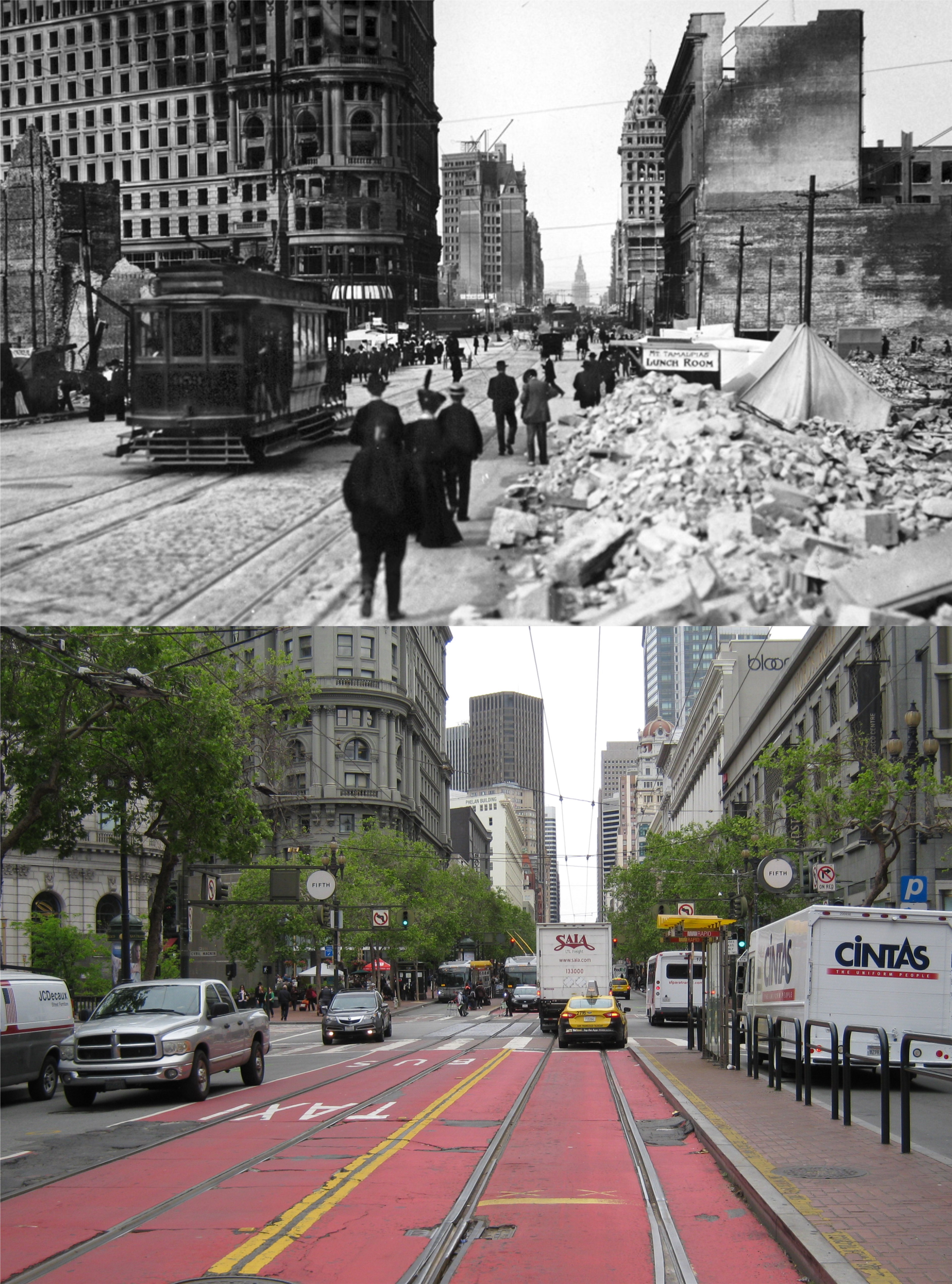 This is looking east on Market Street near 5th. The Flood Building at Powell and Market Streets is at left center. The Call Building on the right, prominent in the vintage photo, is behind the domed Humboldt Building built after the earthquake. The Ferry Building, seen in the old picture, is blocked out by the white freight truck in my photo. (SF Chronicle)