
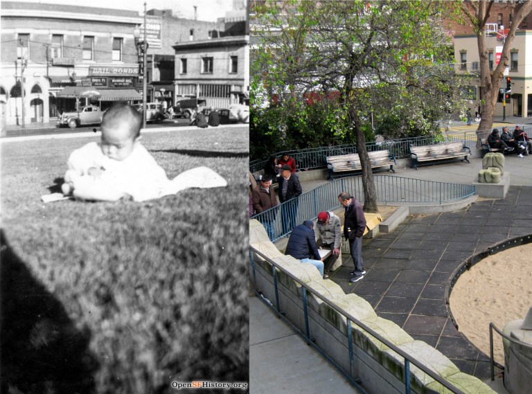
 In 2011, the University of California Press reprinted a 1940 guide to San Francisco written by the Federal Writers Project (WPA) of the Works Project Administration (WPA). The Works Progress Administration was the result of Executive Order 7034, Signed by Franklin D. Roosevelt in 1935 to create jobs for unemployed workers, artists, musicians, etc. during the Great Depression of the 1930s. A lot of the San Francisco we appreciate today, such as the murals inside Coit Tower and the Beach Chalet, and the exhibits at the San Francisco Zoo came about because of WPA. The ‘San Francisco in the 1930s’ WPA Guide has numerical descriptions that correspond with maps in the book. The points of interest listed take in just about all of San Francisco with occasional outdated descriptions that were new in 1940. These are a collection of some of the descriptions of places from the book, (in brackets) with vintage pictures I updated of each location taken close to the period when the book was written.
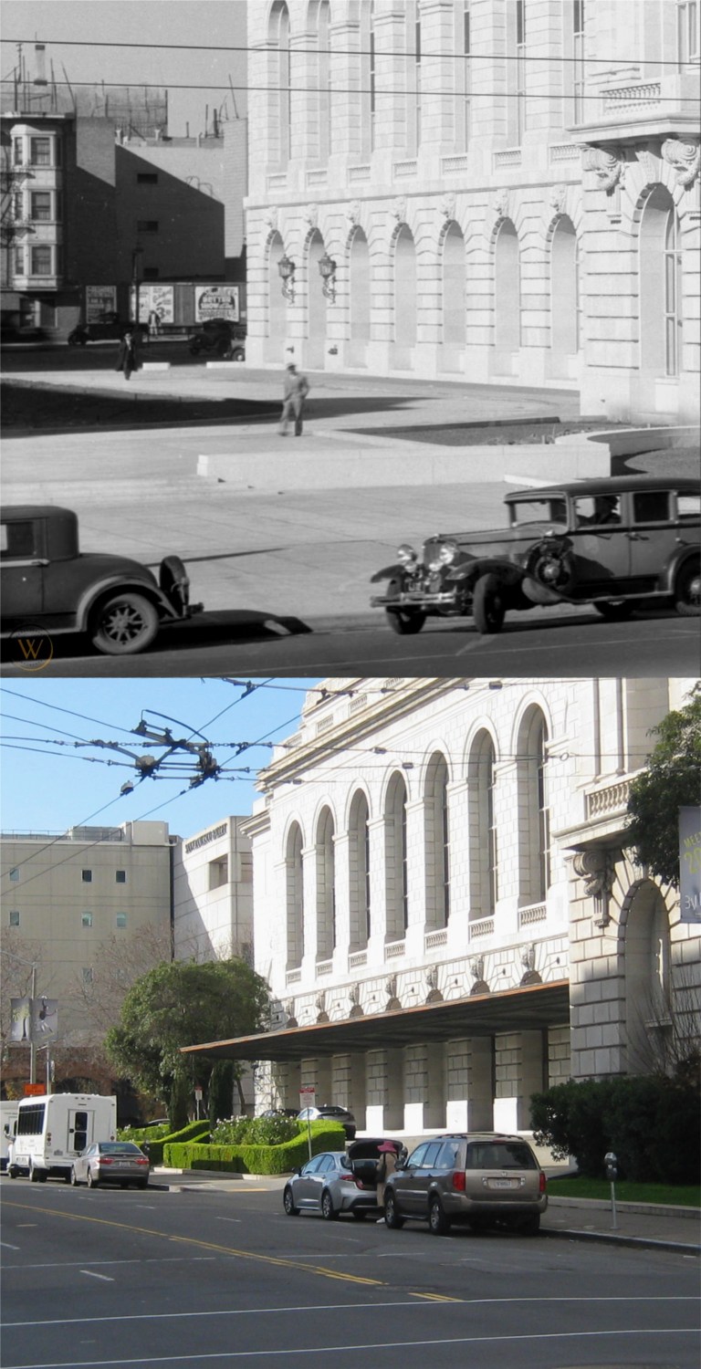 The south side of the Opera House on Van Ness with long gone buildings on Franklin Street in the background: (Vintage picture from worthpoint.com)
{The OPERA HOUSE (open weekdays 10 -4) NW corner Van Ness Ave. and Grove St., and the Veterans Building form the War Memorial of San Francisco, erected in 1932 as a tribute to the city’s war dead.}
{This, the Nations only municipally-owned opera house, represented the achievement of years of struggle by San Francisco music lovers for an opera house of their own. It was opened October 15, 1932 with Lily Pons singing Tosca. The auditorium, seating 3,285 persons, is richly decorated. The floor of the orchestra pit can be raised and lowered. The stage is 131 feet wide, 83 feet deep, and 120 feet from floor to roof.}
The dimensions of the stage area may have changed since 1940.
 The cable car turnaround at Powell and Market Streets:
{Traffic waits good naturedly at the CABLE CAR TURN-TABLE, Market, Powell, and Eddy Sts., where a careening southbound car comes to a halt every few minutes, while conductor and grip man dismount and push the car around until it faces north.}
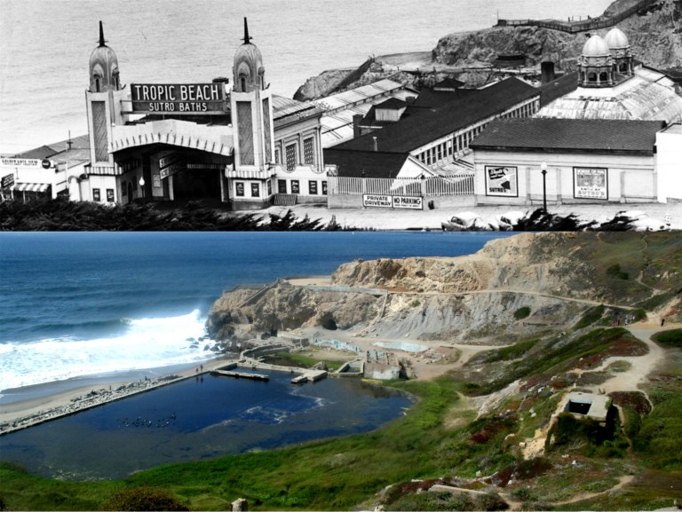 The old Sutro Bathhouse:
{The sprawling building of the SUTRO BATHS AND ICE RINK (open Mon.-Fri. 10 a.m. – 11 p.m.; Sat. , Sun., holidays 9 a. m. – 11 p. m.; skating 35 cents Sun. afternoon and every evening, 25 cents other times; skate rental 15 cents, swimming 50 cents) . Point Lobos Ave. near Great Highway, covering three acres of sloping beach in the lee of Point Lobos, were built in 1896 by Adolph Sutro. Long advertised as the world’s largest are the six indoor pools; of both fresh and salt water, these vary in size depth, and temperature. Also here, are a floodlighted ice rink and an indoor sand plot for sunbathing. It is said that 25,000 persons have visited “Sutro’s” in one day.}
Sutro Bathhouse burned down in 1966.
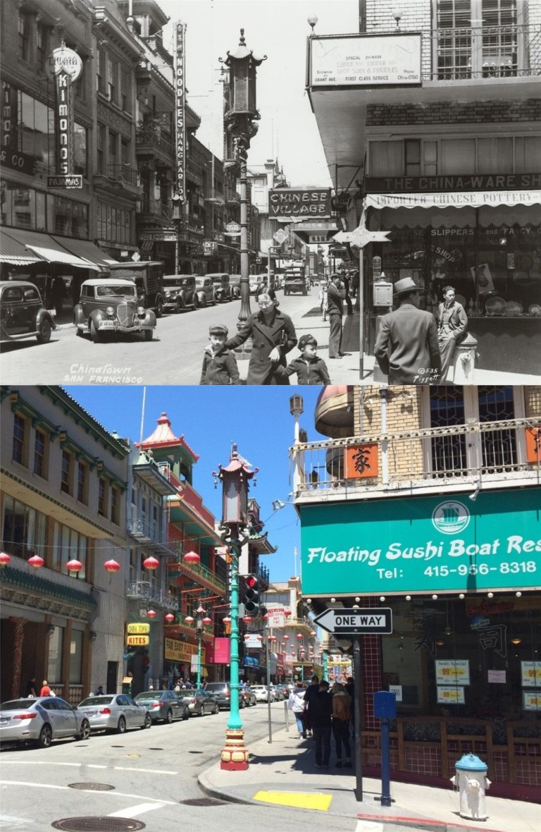 Grant Avenue looking north from Commercial Street:
{A quarter of old Canton, transplanted and transformed, neither quite oriental or wholly occidental, San Francisco’s Chinatown yields to the ways of the West while continuing to venerate a native civilization as ancient the Pyramids. Grant Avenue, its main thoroughfare, leads northward from Bush Street through a veritable city-within-a-city – alien in appearance to all the rest of San Francisco – hemmed within boundaries kept by tacit agreement with municipal authorities for almost a century.}
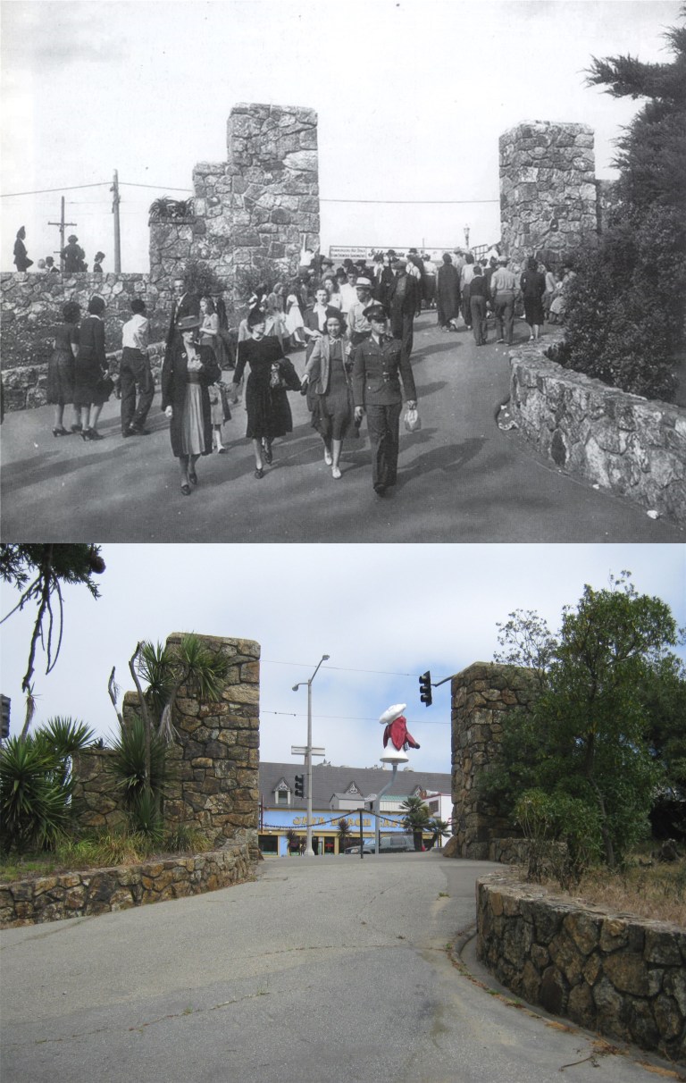 The old WPA built entrance to Fleishhacker Zoo on Sloat Ave.
{FLEISHHACKER PLAYFIELD AND ZOOLOGICAL GARDENS, foot of Great Highway at Sloat and Skyline Blvds. This recreation center dates from 1922, when the city acquired from the Spring Valley Water Company 60 acres on which to construct a playground and pool. Only 37 acres at first were developed; opened in 1924, the park was named for Herbert Fleishhacker , then president of the Park Commission, who donated the pool and the Mothers’ House. Adjoining the playground is the Zoo (open 10 – 4:30; free). Begun in 1929 with a few lion cubs and monkeys, gradually more animals were acquired (by purchase and donation) until the animal, bird and reptile population reached 1,000. Noted is the fine collection of “cats” which includes lions, tigers, leopards, lynxes, and panthers. In 1935 sixty-eight acres adjoining the zoo were purchased and here WPA labor constructed the fine ZOOLOGICAL GARDENS, modeled after Germany’s famous Hagenbeck Zoo. Here, among man-made streams, waterfalls, islands, cliffs and caves, are simulated natural habitats of many animals – separated (where practical) from spectators only by moats and designed to give the animals the illusion of freedom}
The vintage picture is the opening day of the WPA built entrance to the zoo in 1937. I was able to get some pictures there before they boarded it up. (Vintage picture from Images of America)
 One of the pictures I was able to get at the old stone entrance to the zoo on Sloat Blvd before they closed it off was the spot where my 17 year old mother on the left with her cousin Frances sat during a visit to San Francisco from North Dakota in 1939.
 The southeast corner of Portsmouth Square:
{Upon the green, sloping lawns of PORTSMOUTH PLAZA, Kearny, Clay and Washington Streets, Candelario Miramontes, who resided at the Presidio, raised potatoes in the early 1830’s. When the plot became a plaza is not known.}
{Most of the stirring events from the 1840’s to the 1860’s took place here – processions, flag raisings, lynchings, May Day fetes.}
{Here terrified Chinese ran about beating gongs to scare of the fire demons during the earthquake and conflagration of 1906; here came exhausted firefighter to rest among milling refugees; here shallow graves held the dead; and thousands camped during reconstruction. The Board of Supervisors, in December of 1927, restored the square’s Spanish designation of “plaza”.}
Well, maybe so, but I read real San Franciscans prefer Portsmouth Square to Portsmouth Plaza, so that’s what I refer to it as. The buildings behind the vintage picture of the square taken in 1937 are still there today. (opensfhistory.org)
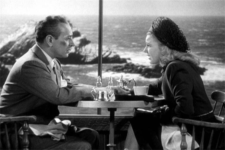
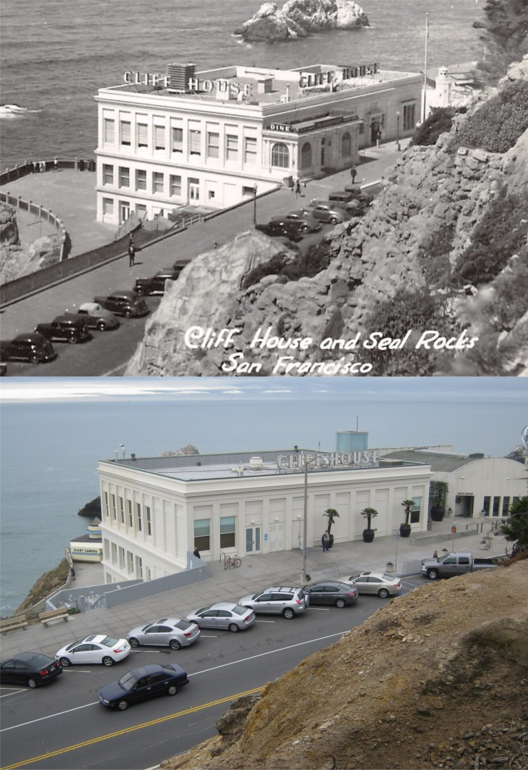 {The CLIFF HOUSE. Point Lobos Ave. at Great Highway, a white stuccoed building terraced along the edge of the cliff south of Sutro Baths, is a modern restaurant, bar, and gift shop. Both the barroom and the Sequoia Room – a cocktail lounge – are finished in redwood, from the smooth walls to rustic beamed ceilings, and both house huge fireplaces in which open fires glow on chilled days. From the lounge and the blue and white dining room in the rear of the building guests seated at the great plate glass windows on clear days look beyond Seal Rocks for miles across the Pacific.}
It’s a crowd pleaser still and you can’t stop progress, but I remember the Sequoia Room with its fireplace well, and I miss the Cliff House the way it was before the New Millennium restoration. (Vintage picture, hippostcard.com)
 The De Young Museum and the Pool of Enchantment:
{On the NW. side of the Music Concourse, flanked by trim lawns and stately Irish yews, is the M. H. DE YOUNG MEMORIAL MUSEUM (open daily 10 – 5). Of Sixteenth- Century Spanish Renaissance design, the buildings pale salmon-colored facades are burdened with rococo ornamentation. Its two wings extend from either side of the 134 foot tower facing a landscaped court. In the court, before the main entrance, lies the POOL OF ENCHANTMENT, in which a sculptured Indian boy pipes to two listening mountain lions on a rocky island.}
Before the De Young Museum was demolished and rebuilt in the New Millennium, I had a chance to take a comparison picture at the spot in front of the museum next to the Pool of Enchantment where my mother, on the right with her cousin Frances posed during her 1939 trip to San Francisco by train while she was in high school. The Pool of Enchantment is now on the eastern side of the De Young Museum.
 The Fisherman’s Wharf Lagoon:
{Twentieth-Century commercialism and Old World tradition go hand in hand at FISHERMAN’S WHARF, foot of Taylor St., where are moored in serried ranks the tiny, bright-painted gasoline boats of the crab fishermen and the tall-masted 70 foot Diesel-engined trawlers of the sardine fleet.}
{The boats of the crab fishing fleet, like their larger sisters of the sardine fleet, are brightly painted, with blue and white predominating hues. During the fishing season (November through August) the crab fleet usually leaves the wharf with the tide – between two or three o’clock in the morning – bound for fishing grounds between three and six miles outside the gate, where each boat anchors within hailing distance of its neighbor. In mid-afternoon they return laden from one to four dozen crabs apiece, accompanied by screaming hordes of gulls.}
Most of the boats in the lagoon in the 1940 picture from the Charles Cushman Collection do appear to be blue and white, and even a number of them today.
 The Embarcadero near Green Street, looking south:
{Even before the eight o’clock wail of the Ferry Building siren, the Embarcadero comes violently to life. From side streets great trucks roll through the yawning doors of the piers. The longshoremen, clustered in groups before the pier gates, swarm up ladders and across gangplanks.}
{Careening taxis, rumbling under slung vans and drays, and scurrying pedestrians suddenly transform the waterfront into a traffic thronged artery.}
{Stored in the Embarcadero’s huge warehouses are sacks of green coffee from Brazil; ripening bananas from Central America; copra and spices from the South Seas; tea, sugar, and chocolate; cotton and kapok; paint and oil; and all the thousand varieties of products offered by a world market.}
Maybe a long time ago, but not anymore. You can’t see the Ferry Building from this spot anymore through the palm trees either, but you can still see the pointed YMCA Building in the far background.
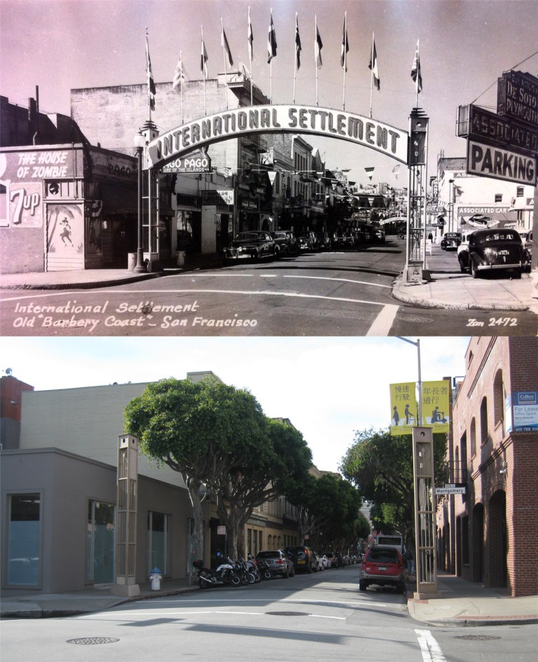 Pacific Avenue and Montgomery Street looking west and the old signposts of the eastern side of the International Settlement:
{The “Terrific Street” of the 1890’s – that block of Pacific Street, SITE OF THE BARBARY COAST, running east from the once-famous “Seven Points” where Pacific, Columbus Avenue, and Kearny Street intersect – is set off now at each end by concrete arches labeled “INTERNATIONAL SETTLEMENT”.}
{Where gambling halls, saloons, beer dens, dance halls, and brothels once crowded side by side, a Chinese restaurant, a night club and cocktail bar, a Latin American café, and an antique shop now appear,}
World War Two would change all that after this passage was written when soldiers and sailors on leave brought back the “gambling halls, saloons, beer dens, dance halls, and brothels”. It’s interesting how they referred to it as Pacific Street in the book rather than Pacific Avenue. The House of Zombie and Pago, Pago Buildings on the left are still there. (Vintage picture, Flickr)
 Mason and Sacramento Streets looking west in 1956: I think I’m far enough out in Sacramento Street with my picture; the traffic lanes were just different back in 1956. (San Francisco Pictures)
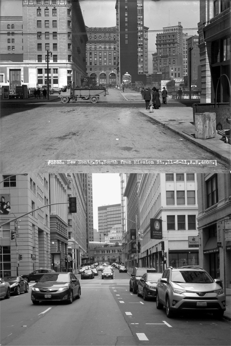 New Montgomery Street, looking north toward Mission Street in 1911: The Palace Hotel, which is the prominent building on the left in the vintage photo, can just barely be seen from here today. The Number One Montgomery Building, built in 1908 and seen in the far background in my picture, had its top portion removed in the 1970s. It angles differently and appears farther away than the old building on the corner of Market and Montgomery Streets in the vintage picture because they’re not on the same block. The old Crocker Building in the background of the old photo was demolished and Number One Montgomery is actually on the corner of Post and Montgomery Streets, which cuts in a different direction. (San Francisco Pictures / SFMTA Photo Archives)
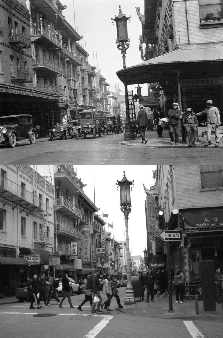 Grant Avenue at Washington Street: The blog lists the vintage picture as from 1920. I’m sure I’m standing in the same spot, but the old and same buildings on the west side of Grant Avenue on the left don’t line up. I’ll put it down to an optical illusion. (San Francisco Pictures)
 Mason and Sacramento Streets looking east in 1956: Sometimes I’ll do an update photo and think I got the picture at just the right spot, and then when I put it together with the vintage picture I’ll say to myself, “Darn, I should have been more to the left!” or “Darn, I should have been more to the right!” or “Darn, I should have been closer!” or “Darn, I should have been farther back!”. I don’t always say “darn” either. I missed this one, alright. I should have been farther out in the intersection, but it’s a busy crossing and I never get a good line up when I’m looking back over my shoulder while I take the picture. (San Francisco Pictures)
 Washington Street at Hyde looking east in 1957: I got a pretty good line up on this one, but that’s not the interesting thing about the picture. The Washington Street cable car line used to run west past Hyde Street all the way to Steiner Street. The line had been discontinued by 1957 but you can still see the cable car tracks at the bottom of the vintage picture. (San Francisco Pictures / SFMTA Photo Archives)
 Looking north along Hyde Street in 1957 from the same intersection at Washington Street as the previous picture: Trees block most of the view along Hyde Street today. The vintage picture was probably taken from the back of a cable car, and the tracks curve a little differently today due to the O’Farrell Line that used to continue south along Hyde as far as Pine Street once, and the cable car overhaul of 1982 and 1983. (San Francisco Pictures / SFMTA Photo Archives)
 A cable car plunging down Washington Street from Jones in 1947: I gave it a try; “Close but no cigar”, or cigarette, or even a vape! (San Francisco Pictures / SFMTA Photo Archives)
 Jones Street looking south toward Post Street in 1913: This one was a pleasant surprise; usually I’m not far enough out into traffic when I take my picture, on this one I was too far out in the street. The construction work on Post Street was probably for the laying of streetcar tracks that by then began to replace cable car lines. However, you can still see the Jones Street cable car lines heading up Nob Hill. Good 1913 advertising; I suddenly have a craving for a stick of Wrigley’s Spearmint Gum! (San Francisco Pictures / SFMTA Photo Archives)
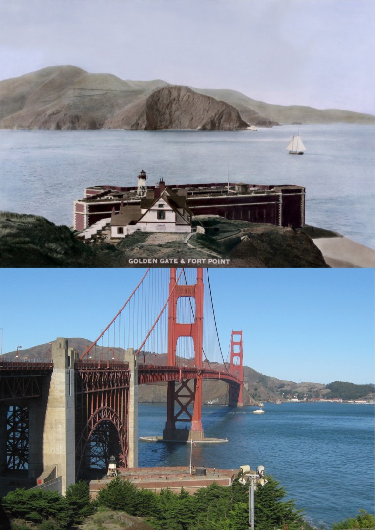 The Golden Gate and Fort Point in the 1880s:
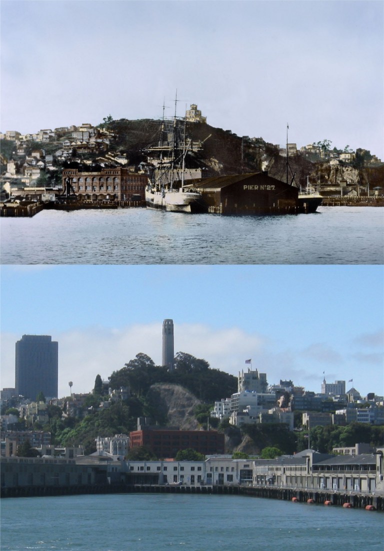 The San Francisco waterfront beneath Telegraph Hill in 1885 before the Embarcadero Piers were built: Dynamite blasting of Telegraph Hill in the late Nineteenth Century, particularly by the brothers George and Harry Gray for their stone quarry, removed the natural slope of the eastern side of the hill before it was stopped early in the Twentieth Century. You can see the damage the Gray Brothers caused in my picture.
 The area that used to be called Meiggs Wharf but is today’s northern waterfront and Fisherman’s Wharf in the 1870s: Alcatraz Island, the Tiburon Peninsula, Angel Island and Sausalito can be seen in both pictures.
 Montgomery Street at Sutter looking south toward the old Palace Hotel in the late 1870s:
 The waterfront looking down from Telegraph Hill in 1865:
 The Vallejo Street Wharf looking toward Telegraph Hill in 1866: Much of this area has been filled in now.
 Looking down from Telegraph Hill toward Vallejo Street and Broadway, where most of the ships docked back in 1865:
 The wharf near Broadway, the opposite view of the previous photos, looking back toward Telegraph Hill: The picture is dated 1850, which would make it one of the oldest pictures or daguerreotypes of San Francisco known.
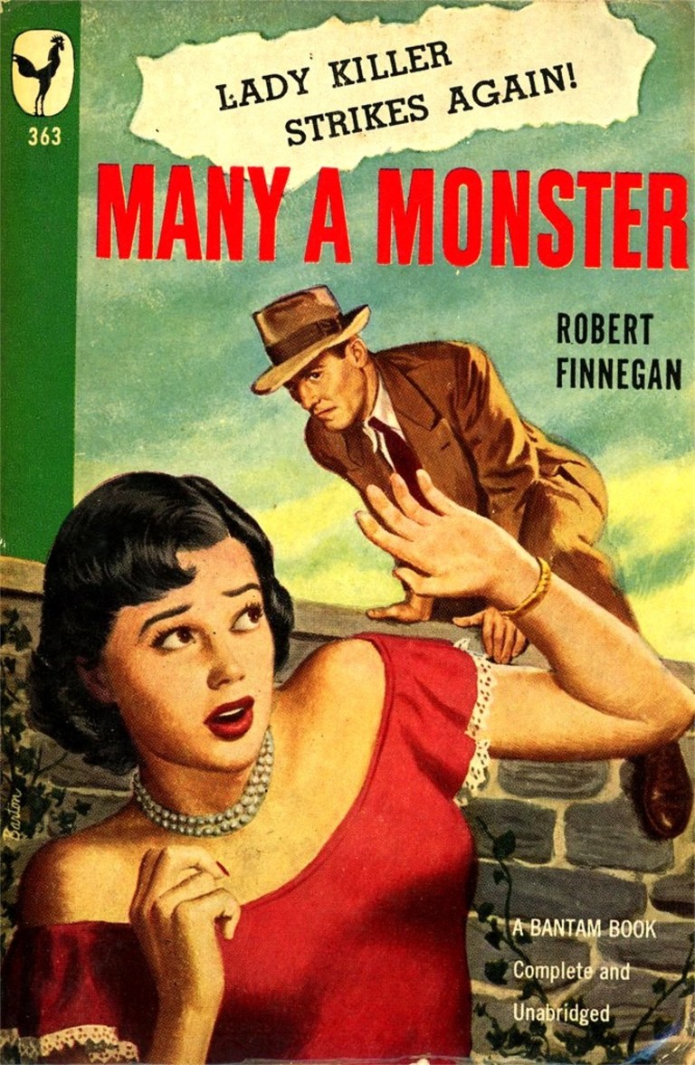 In ‘Many a Monster’ written in 1948 by Robert Finnegan, Dan Banion is a newspaper reporter trying to prove the innocence of a fugitive from the police, hiding in San Francisco and wanted for the gruesome serial killings of four women.
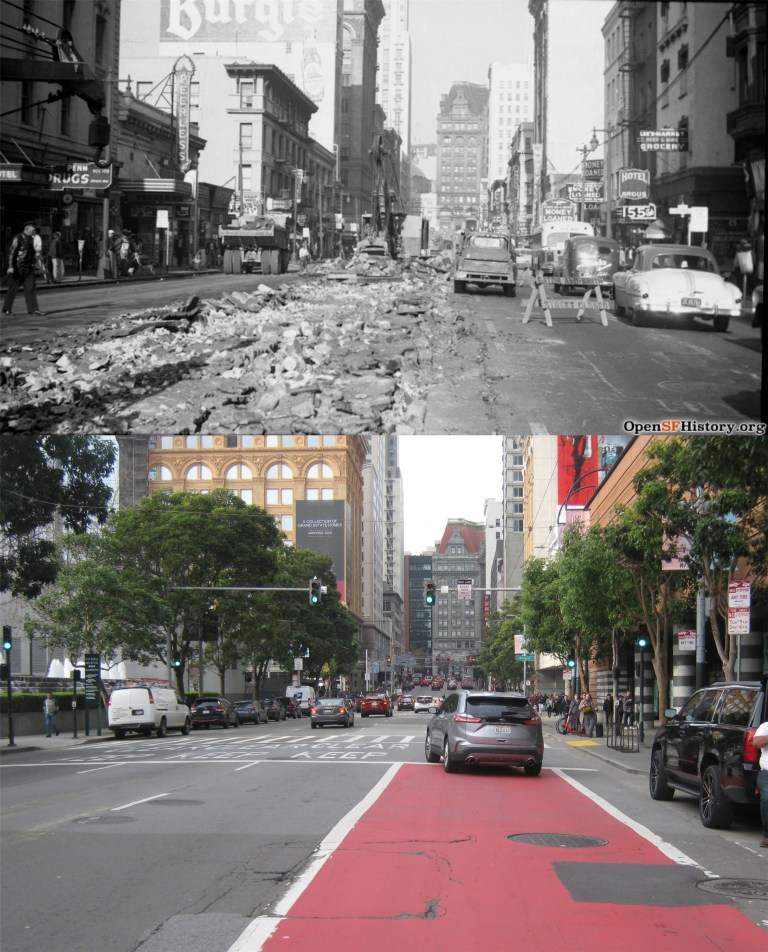 Read Banion’s dreary description of 3rd Street as he turns onto it from Market Street looking for clues.
 {Farther up the street, Dan could see the neon sign of the Regent Theater projecting over the sidewalk.}
 In ‘My Dead Wife’ (Is that a grabber title or what?) written in 1948 by William Worley, Frank Terrance who lives on the Telegraph Hill part of Kearny Street, (Curiously, the author spells it Kearney Street) is a depressed and lonely man in love with his unfaithful wife who has left him. His wife, Jessie, shows up at his apartment in the first chapter broke and obviously in some type of trouble. Torn between his feeling for her and aware that she doesn’t love him, he begins drawing back to her in spite of himself. Hey, we’ve all been there. The reunion doesn’t last long because while he’s in the kitchen mixing Jessie a drink she’s shot to death while sitting in his arm chair. Well, at least Frank had the sense enough to slam down the drink he made for Jessie when he saw her bleeding in the chair. After kneeling on the floor by her to make sure she’s dead, Frank panics fearing he may be blamed and quickly leaves his apartment.
 {I walked down to Columbus and turned into Grant Avenue. I walked at a steady, easy pace through Chinatown towards Market Street. I went past the wailing and whining of the Chinese theater, past the night clubs and their displays of Chinese fan dancers, past the bars and chop suey parlors, the joss houses, the entrances where tourists never go, past the glittering Chinese art stores and the stench of poultry and fish markets.}
 Terrance stops at his walk along Grant Avenue here at Grant and Geary Blvd. and goes into a cocktail lounge and begins to drink heavily until he notices the other customers staring at him with curious looks. He discovers that he has blood on his face and clothes from his murdered wife. The vintage picture is from 1957.
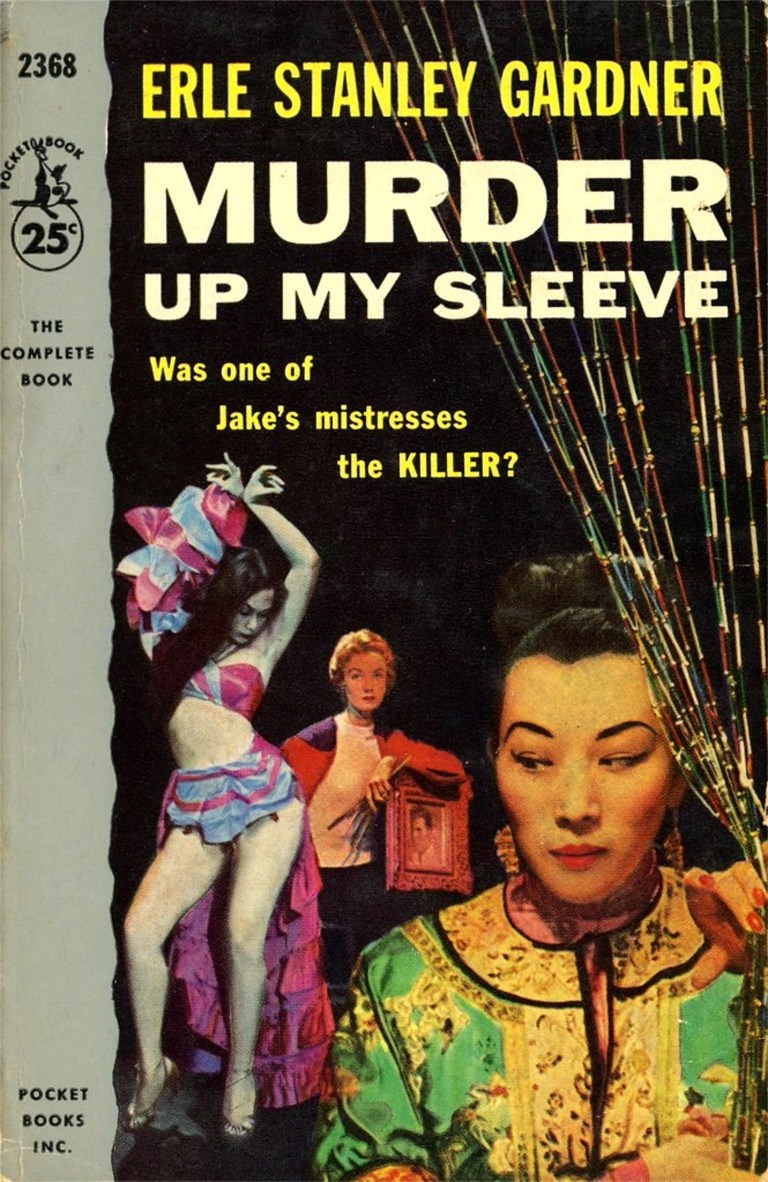 ‘Murder Up My Sleeve’ was written in 1937 by Erle Stanley Gardner, the creator of Perry Mason, although Perry Mason isn’t in this book. I liked this one the best; however, some readers might find it lacking in action. Much of the dialogue between the characters is surprisingly contemporary, and I developed a crush on Cynthia Renton right from the first page she appears in. Our hero is Terry Clane who is often referred in the book as an “adventurer”. Clane is summoned to the District Attorney’s office in the opening of the book because a blackmailer named Jacob Mandra has been murdered with a “sleeve gun”. A sleeve gun is a weapon that can be hidden in the sleeve and fires a deadly dart that can be launched by pressing your arm against a solid object, such as a desk. Terry Clane owns such a weapon.
 The District Attorney tries to intimidate Clane by reading to him from a dossier his office has collected on our “adventurer”, including this information.
 Clane travels through the Stockton Tunnel to Chinatown to visit Chu Kee who lives on Stockton Street. Chu Kee’s daughter, Sou Ha, knew Jacob Mandra and was one of the last people to see him alive. Clanes’s encounter with Chu Kee and Sou Ha has an atmosphere of danger that reminded me of when Bette Davis goes to meet mysterious Gale Sondergaard to purchase a letter that will incriminate her in the murder of her lover in the 1940 film ‘The Letter’. Clane describes coming out of the north end of the Stockton Tunnel and entering Chinatown.
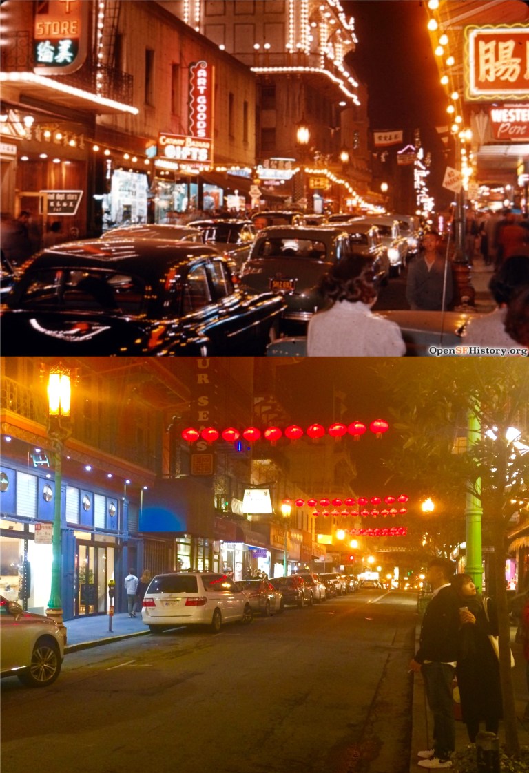 Later on Clane drives along Grant Avenue in Chinatown at night with Sou Ha.
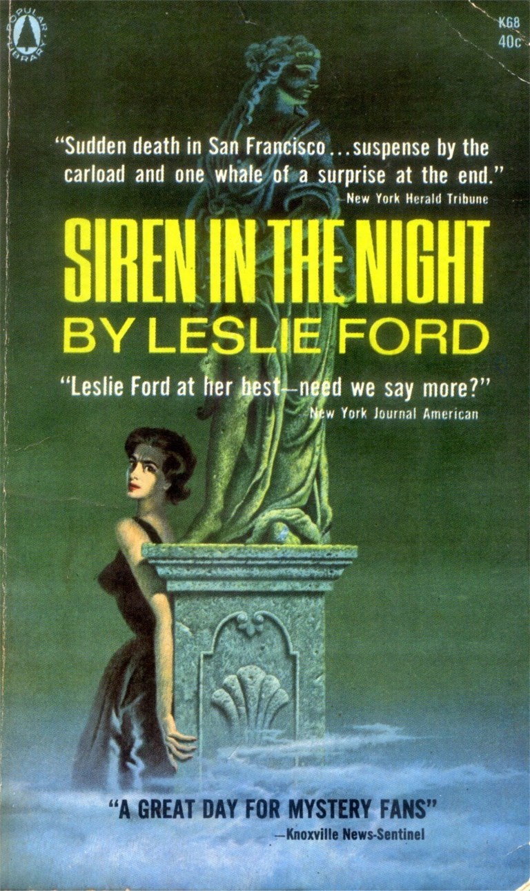 ‘Siren in the Night’ written in 1942 by Leslie Ford received the best reviews of the books I read, but I found it really slow in parts. It concerns a murder committed during a blackout and siren warning alerting San Franciscans of a possible air raid that was common in the city in 1942. In one chapter the heroine, lady detective Grace Latham, walks down Nob Hill with a Colonel John Primrose from the Mark Hopkins Hotel to Jack’s Restaurant on Sacramento near Montgomery Streets. Written in first person, Detective Latham describes the San Francisco sites as they walk along.
 {We walked down California Street. The cable cars clanging up the hill were jammed with people sticking on like caviar on a forty –five degree oblong of toast.}
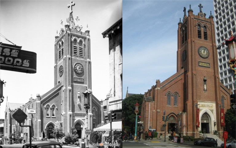 {The clock on the square dark tower of St. Mary’s was striking seven. The gold inscription above it – “Son Behold the Time and Fly From Evil” – was glistening in the low shafts of sunlight through the Square across the street.}
 {The sun shone too on the stainless steel robe of Sun Yat-sen , his rose marble face , benign and placid, gazing out over the green Square.}
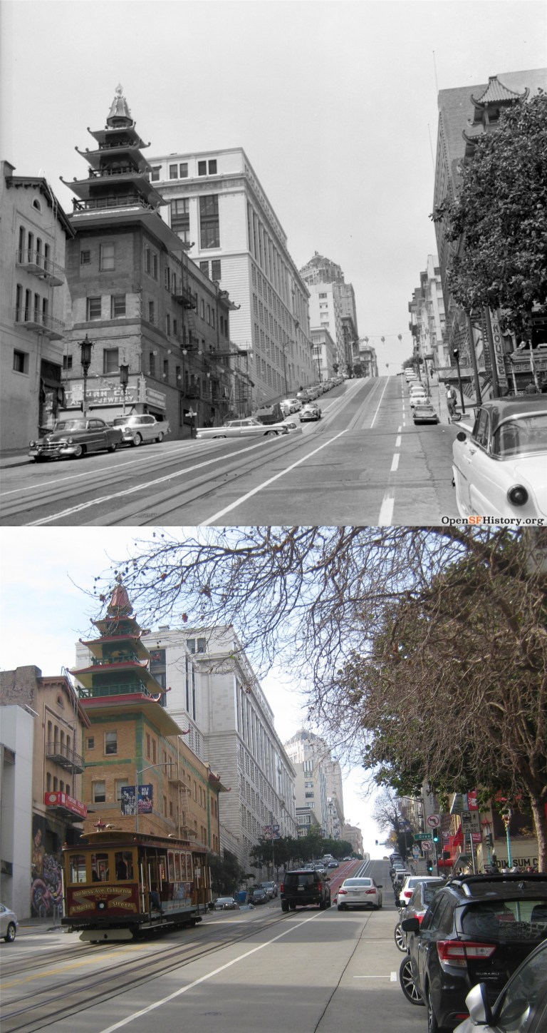 {We turned the corner where the five-tiered pagoda towers stand, green and yellow faded to chartreuse.}
 {We turned down Sacramento Street through the crowded section where Chinatown streams across it into the deserted stretch toward Montgomery Street. There was a parking lot on either side of the restaurant we were going to.}
 ‘Murder Loves Company’ is a long out of print book written in 1940 by John Mersereau. It takes place during the second year of the Golden Gate International Fair on Treasure Island. Although, corny at times, it’s page-packed with descriptions of many of the fair’s attractions and the best first-hand account of the world’s fair you’ll get in a book of fiction.
 The book opens up with a deadly accident just east of the Yerba Buena Tunnel that nearly involves Professor Biddle and a lady reporter named Kay Ritchie as they exit the tunnel while driving across the Bay Bridge to Berkeley.
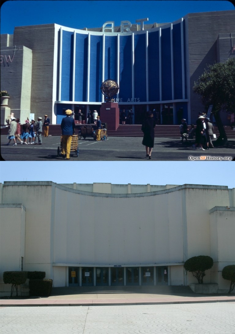 Later on in a visit to the fair, the book describes the Treasure Island attraction this way as Professor Biddle takes a ferryboat to the fair
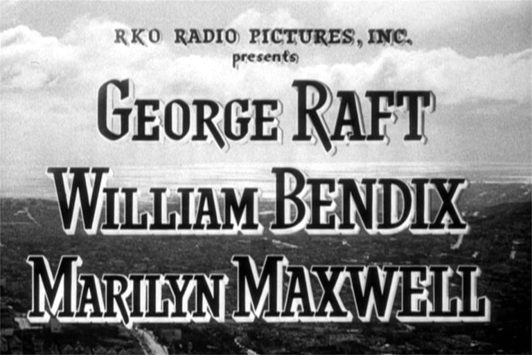
 The film stars George Raft. Raft originally made it on the map with his coin flipping gangster scenes in the 1932 movie ‘Scarface’ with Paul Muni. Check out Bugs Bunny’s George Raft impersonation on the link below.
 Raft’s girlfriend is Marilyn Maxwell, who helped introduce the song ‘Silver Bells’ with Bob Hope in ‘The Lemon Drop Kid’ from 1951.
 The film also co-stars Harry Morgan, probably most famous as Colonel Potter in the television show ‘M*A*S*H’.
 But to me the star of the movie is the character actor William Bendix. I like him in everything he was in. His best role was probably Gus in Alfred Hitchcock’s 1944 film ‘Lifeboat’. “Give us a kiss, toots.” Gus says to Tallulah Bankhead as she’s about to assist in amputating his leg. (She does) Bendix plays a nice guy cop trying to keep Raft out of trouble.
 The movie shows a panoramic sweep of San Francisco from Twin Peaks behind the opening credits.
 The view from Twin Peaks now:
 The movie opens up with a 1948 view from the Top of the Mark.
 The story starts out showing a number of San Francisco locations. This is the cable car turnaround at Powell and Market Streets looking toward Eddy Street. The building with the Gray’s Suits advertisement was demolished and Eddy no longer cuts through to Market Street. This is where Hallidie Plaza is now. You can see the old JC Penny’s Store building on the corner of 5th and Market Streets in both pictures.
 This is Montgomery Street at Market Street looking north.
 The action starts with a customer going into the clothes store front for Raft’s bookie business on Post Street across from Union Square. The building the clothes store was in may have been the fashionable men’s store, Bullock & Jones, which is now Williams-Sonora. The building is still there.
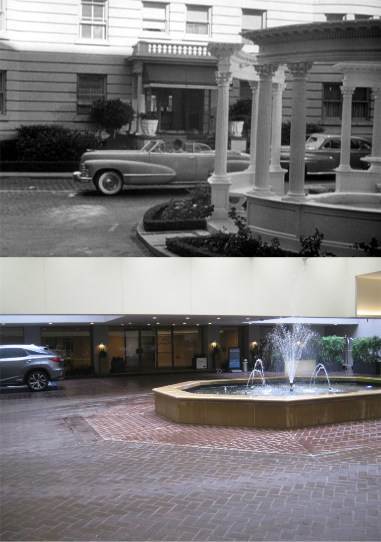
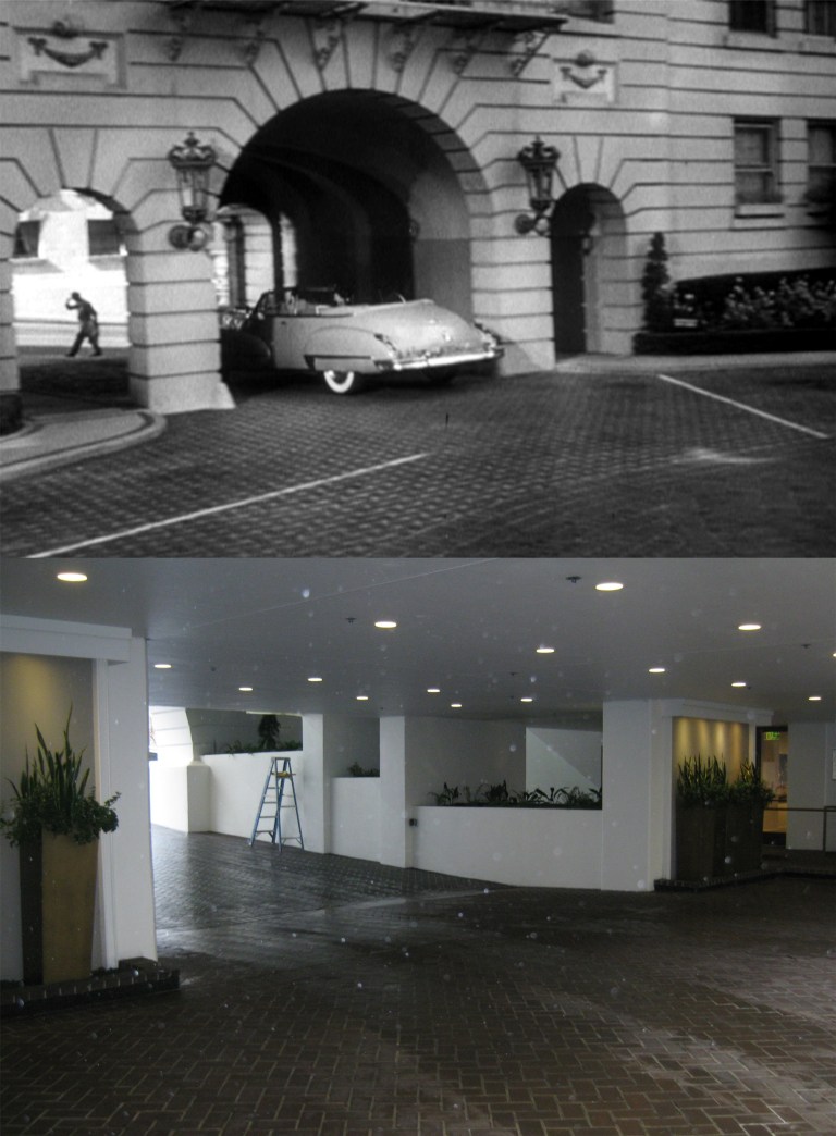 Raft’s squeeze, Marilyn Maxwell, lives in the Stanford Court Building on Nob Hill on California Street. Here, they’re leaving the courtyard, still there but not as fancy.
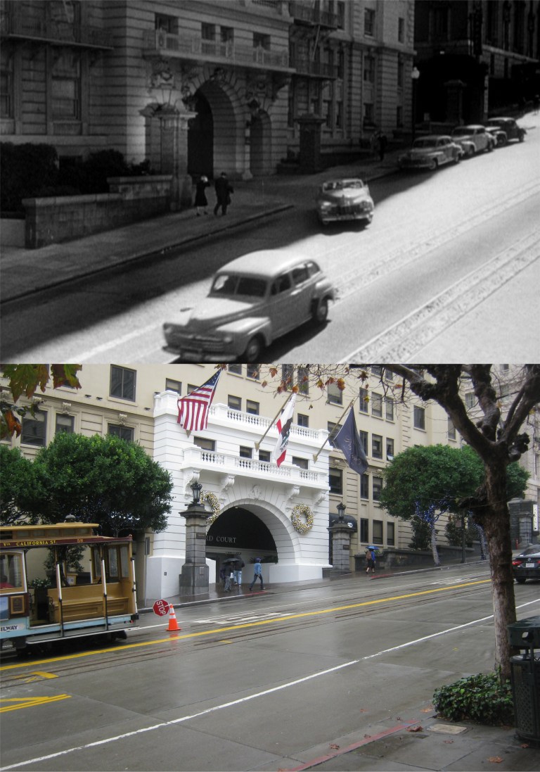 They merge onto California Street across from the Fairmont Hotel.
 They cross Powell Street at California Street, the only place where the three remaining cable car lines cross each other.
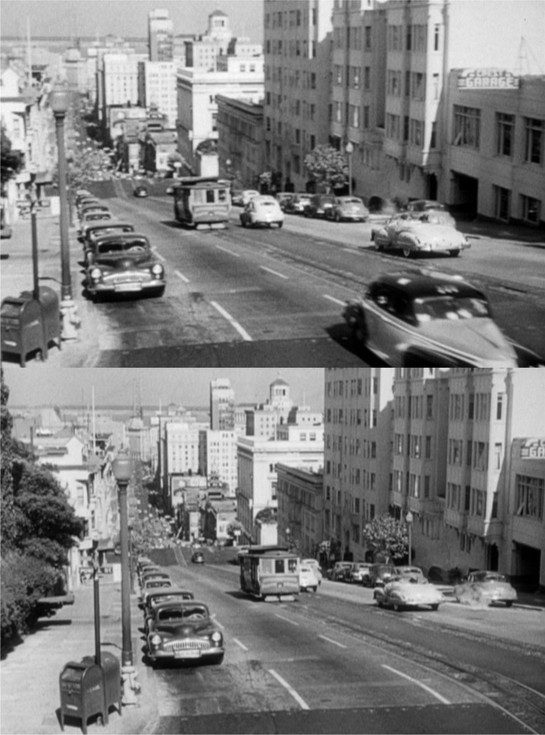 The two head down California Street past the old Crest Garage, demolished in 2018.
 The view down California Street from here now:
 Raft lives on Nob Hill as well at an apartment building on the southwest corner of Jones and California Streets. The tall building in the far background is the old Empire Hotel Building in the Civic Center area. You can just barely see it through the rainy mist in my picture.
 He drives down the west side of Nob Hill and turns into his parking garage.
 I’ll have to ask my arborist friend, Tony, if that could possibly be the same hedge that was growing there in 1948. He’ll probably think that’s a ridiculous question, but I have vines growing in the back yard of my house that go back to the 1960s.
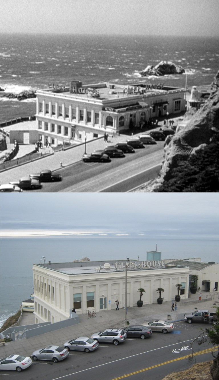
 The movie even takes a trip out to the Cliff House where Raft has lunch with his sister who is worried about his prospects for bucking the mob. Seal Rocks are in the background of the lunch scene.
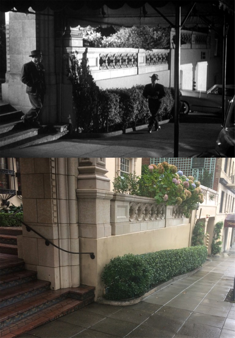
 I’ll close with a few of the scenes filmed at night. Refusing to be intimidated by the mob, Raft is intercepted by one of “the boys” going into his apartment. I’ll bet he has a gun in his pocket! I’m bright about things like that.
 Raft gets taken for the proverbial “ride”. It’s never a good sign when one of the hoods gets in the back seat with you and not in the empty front seat.
 Mr. Big, played by Frank Faylen, tells Raft he had better get in line. This would certainly persuade me! Raft plays along with him to bide time, although they rough him up pretty good.
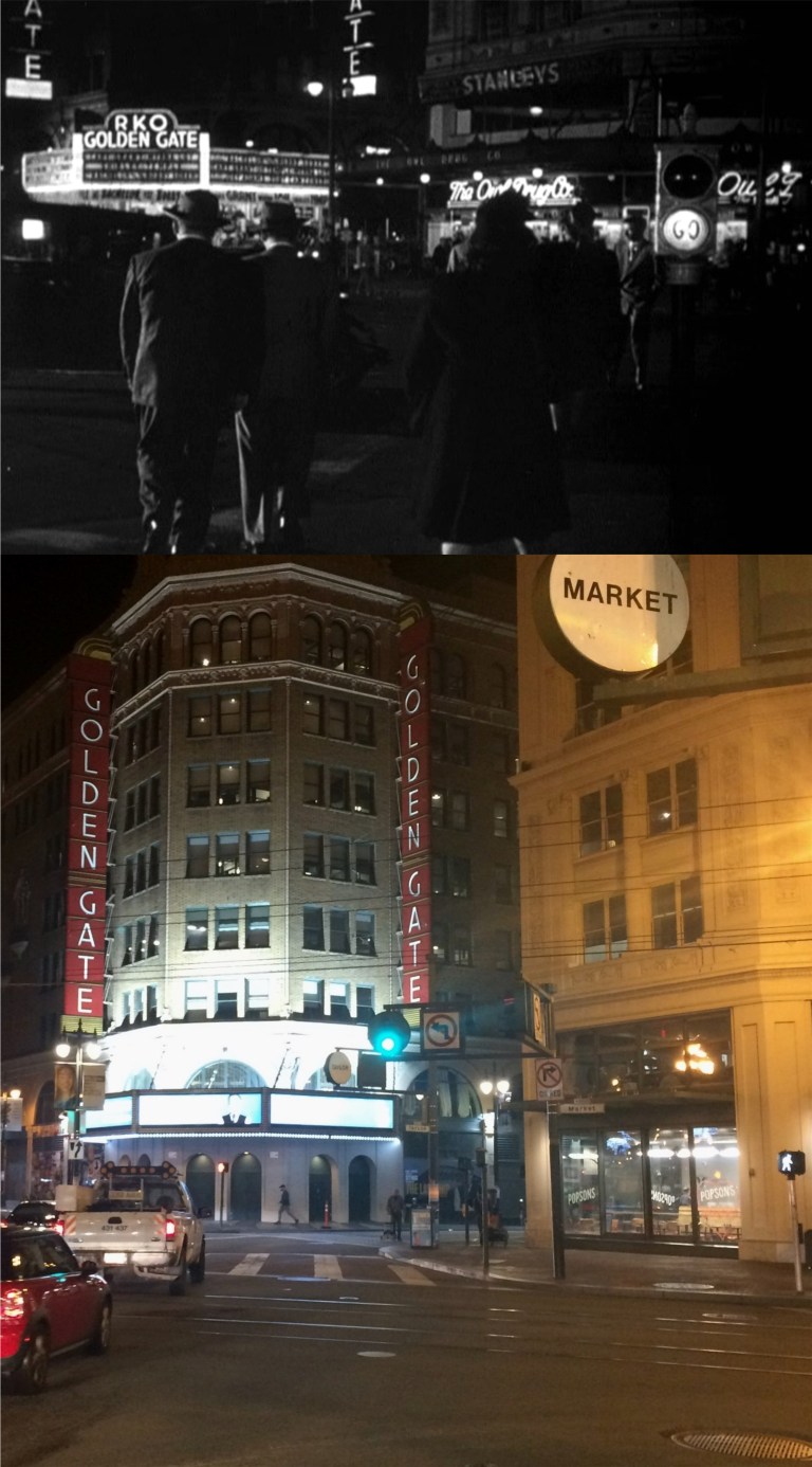 In one scene, Bendix tries to talk Raft out of taking the mob on without involving the police as they cross Market Street from 6th Street toward the Golden Gate Theater, at that time owned by Howard Hughes’ RKO Movie Studio.
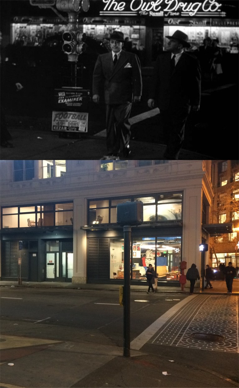
 The movie ends back where it began at the Top of the Mark for a nighttime view of the City, and closes out overlooking the Embarcadero and the Bay Bridge. The closing music even plays a little of ‘San Francisco’ from the 1936 movie.
 Nick and Nora Charles getting pulled over on the Bay Bridge while they were heading east to the Golden Gate Fields in Albany in the 1941 film ‘The Shadow of the Thin Man’. A lot of new buildings have sprung up in SOMA since I took this picture about 7 years ago.
 I should redo this one I did in 2013 in honor of the closing at the end of this year after running for over 45 years of the San Francisco musical ‘Beach Blanket Babylon’.
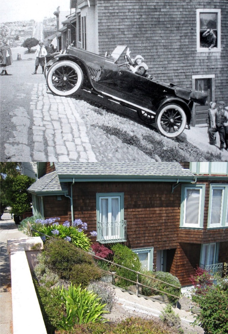 I’d like to redo this 1920’s photo from the Image of America Series taken at the top of Duncan Street in Noe Valley just to go there again.
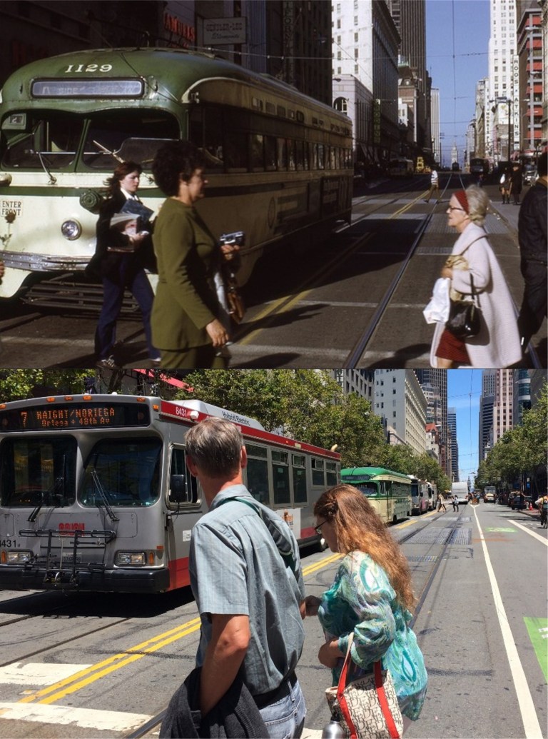 Market Street at Powell Street in the 70s: Ah, if only the vintage F Line streetcar behind the number 7 Muni bus would have been the one in the lead!
 I was leaving Treasure Island with friends in October of 2014 when this view of the eastern span of the Bay Bridge being dismantled reminded me of a fuzzy picture had in my computer of the bridge being built from this angle. I snapped a quick picture as we passed. I’d like to redo it, but never will.
 Looking south toward the old Southern Pacific Train Depot and the Lefty O’Doul Bridge from Brannan Street in the 1940’s: I’ll have to borrow someone’s crane if I’m going to get this one accurate in a redo.
 The opening of the Bay Bridge in November of 1936: As I mentioned in the opening picture to this post, a lot of new buildings have sprung up in the background since I took this picture in January of 2015.
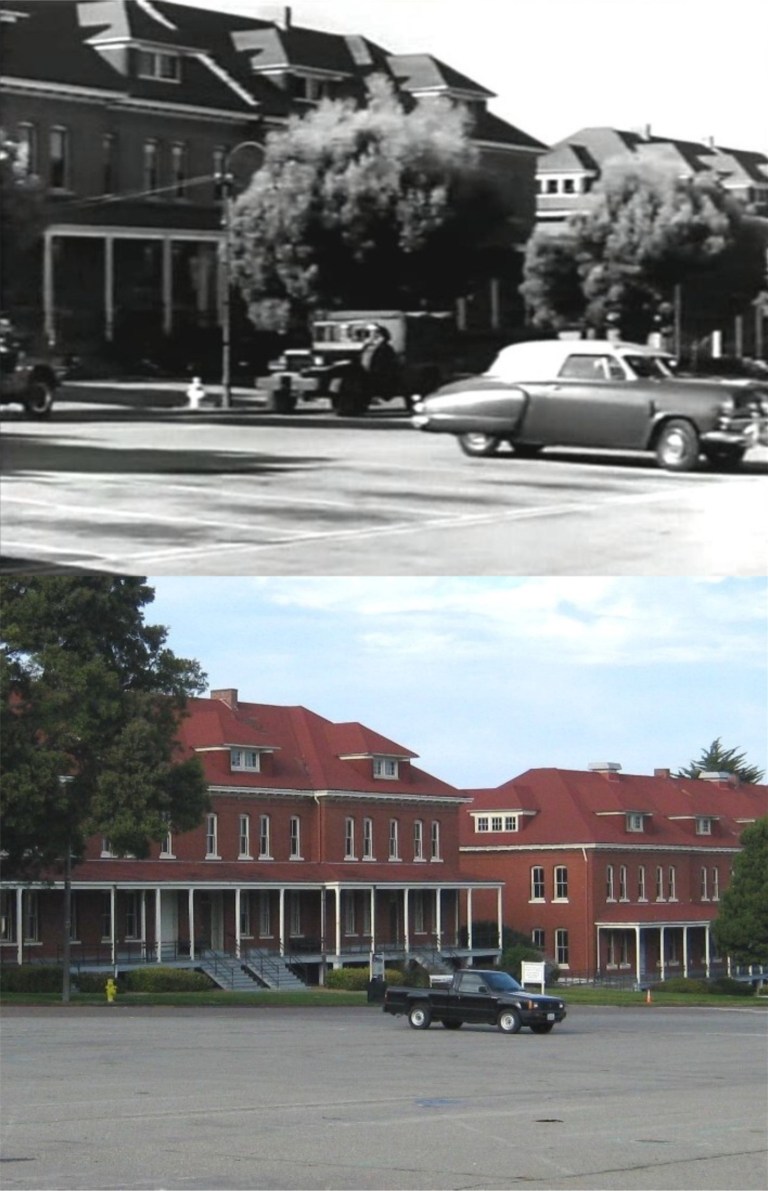 The old Montgomery Barracks in a scene from an odd 1950 film called ‘Experiment Alcatraz: Here, prisoners from Alcatraz Prison are being transported by the army to a location in the Presidio to participate in a medical experiment that may earn them their freedom. To me, the star of these pictures is my old truck that still runs. This area is all grass now, and more visitor friendly than when I took the original picture.
 I should probably redo this one on a regular basis to see if this building on the corner of Hayes and Laguna Street continues to survive. This was where the dental office of John McTeague was located in the 1924 film ‘Greed’, a movie that is considered one of the greatest films of all time.
 Almost a perfect matchup, except that I’m 210 feet higher than from where the vintage postcard was taken: I’ll redo it from the Coit Tower parking lot instead of at the top of the tower after they cut back all of those trees blocking most of the view from the parking lot nowadays.
 Buffalo Bill at the Cliff House: I’d give anything to redo this one if my best friend could be in it again.
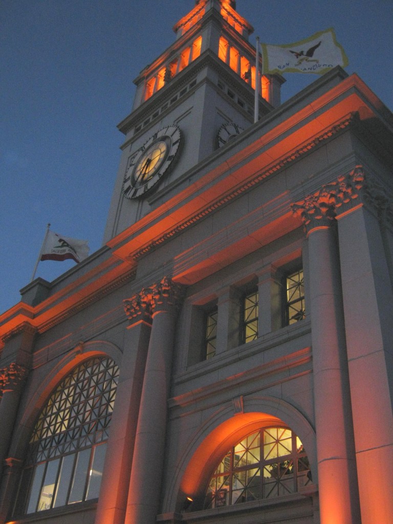 The Ferry Building on Halloween, 2010: No, that orange wasn’t for Halloween, the Giants were just about to win their first World Series in San Francisco. I’ll redo it again the next time they win the World Series.
 Last February I mentioned that someday I’d like to redo the top then and now picture I posted of the east entrance to the Union Square Garage taken during the 1940s. The source of the vintage picture was the Facebook page San Francisco Remembered. The Stockton Street construction on the Muni Metro extension to Chinatown made for a poor comparison picture back then. They’ve finished this portion of the new rail line and I was able to get a better then and now picture in between rain showers today. Back in the 40s Union Square had four entrances and exits; north, south, east and west. Today, there’s only the north and south drive-through on Post Street and Geary Street.
 With lower Stockton Street open again after so many years they’re not about to close it again, so they moved the street mall to Grant Avenue between Geary Blvd. and Post Street, and Maiden Lane. The vintage picture here on Grant Avenue is from 1960. (Source, opensfhistory.org)
 The pedestrian mall used to run along Stockton Street from Market Street to Geary Blvd for years. This picture of mine was taken in 2016 between O’Farrell Street and Geary looking toward the old Macy’s clock. The vintage picture is from the 1940’s.
 There were a lot of Maidens in Maiden Lane in this picture from 1949. (opensfhistory.org)
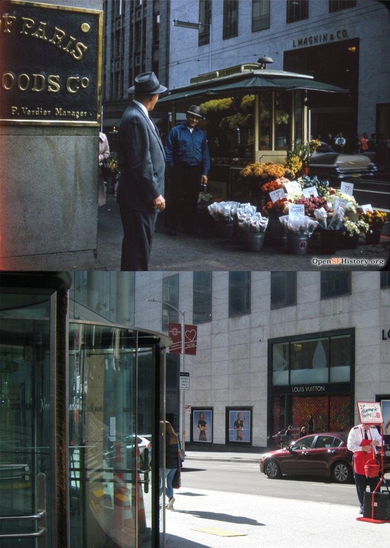 The southeast corner of Stockton Street and Geary St. in 1958, looking toward the old I Magnin Department Store: The vintage picture was taken near the entrance of the much loved City of Paris Department Store. (opensfhistory.org)
 The City of Paris seen from Union Square in the 1940s: Forsaking a rally to save the old landmark building, it was demolished in 1979. The Neiman Marcus Department Store is there today. (SF Chronicle)
 Neiman Marcus had the class to save the painted glass ceiling from the rotunda of the City of Paris, and you can step back in time for a minute when you go up to look at it. (SF Chronicle)
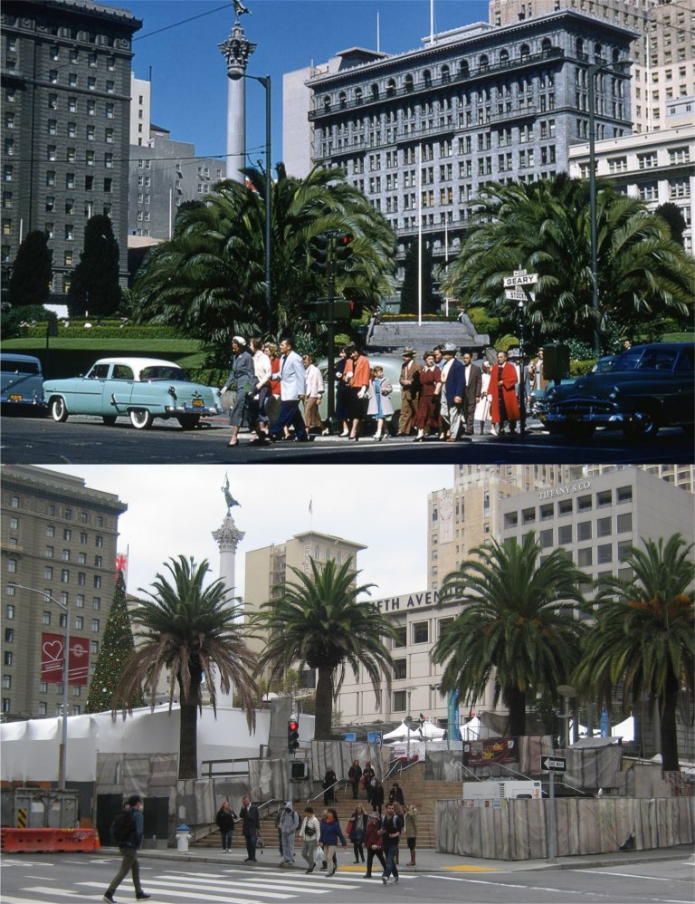 The northwest corner of Geary St. and Stockton Street looking toward Union Square during the 1950s: (San Francisco Pictures Blog)
 I’ve been waiting for awhile for them to clear the construction off Stockton Street from the MUNI expansion to Chinatown so I could get a comparison picture of this Charles Cushman Collection, looking past Maiden Lane toward Post Street in the 1950s.
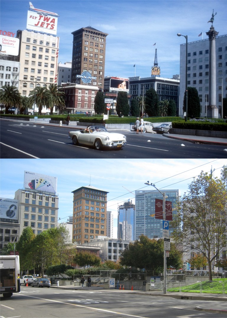 The north entrance to the Union Square Parking Garage on Post Street in 1967: The vintage picture is a nice time capsule. (San Francisco Pictures Blog)
 A gloomy 1987 picture along Post Street from Powell Street in 1987: San Francisco has had days like the older picture a lot recently, but yesterday was a little nicer. (San Francisco Pictures Blog, Rob Weststrate)
 The Ferry Building and the Ferry Building: The bottom picture is a gingerbread Ferry Building on display this season in the lobby of the Ferry Building
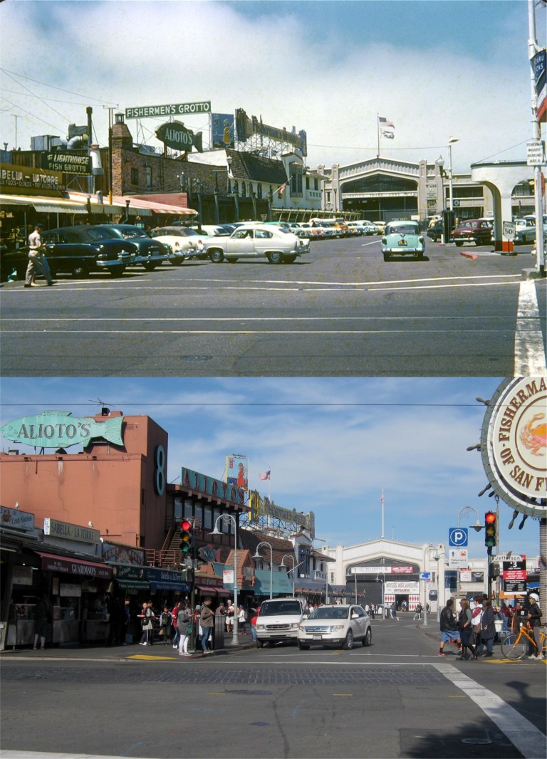 Jefferson and Taylor Streets looking north, probably the most recognizable view of Fisherman’s Wharf and one of the most photographed intersections in the city: The vintage picture is from 1953. (San Francisco Pictures blog)
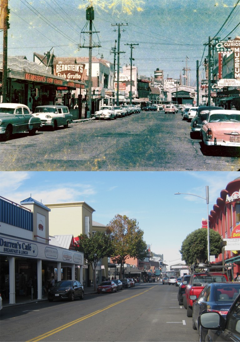 One block south of the previous picture on Taylor Street in 1956: Somebody didn’t take very good care of this old picture.
 Looking southwest along Taylor Street from Jefferson in 1963: The Z backwards K Gallery is where the old Sea Captain’s Gift Shop used to be. Personally, I think Fisherman’s Wharf lost a little of its atmosphere when that gift shop went out of business. (San Francisco Pictures blog)
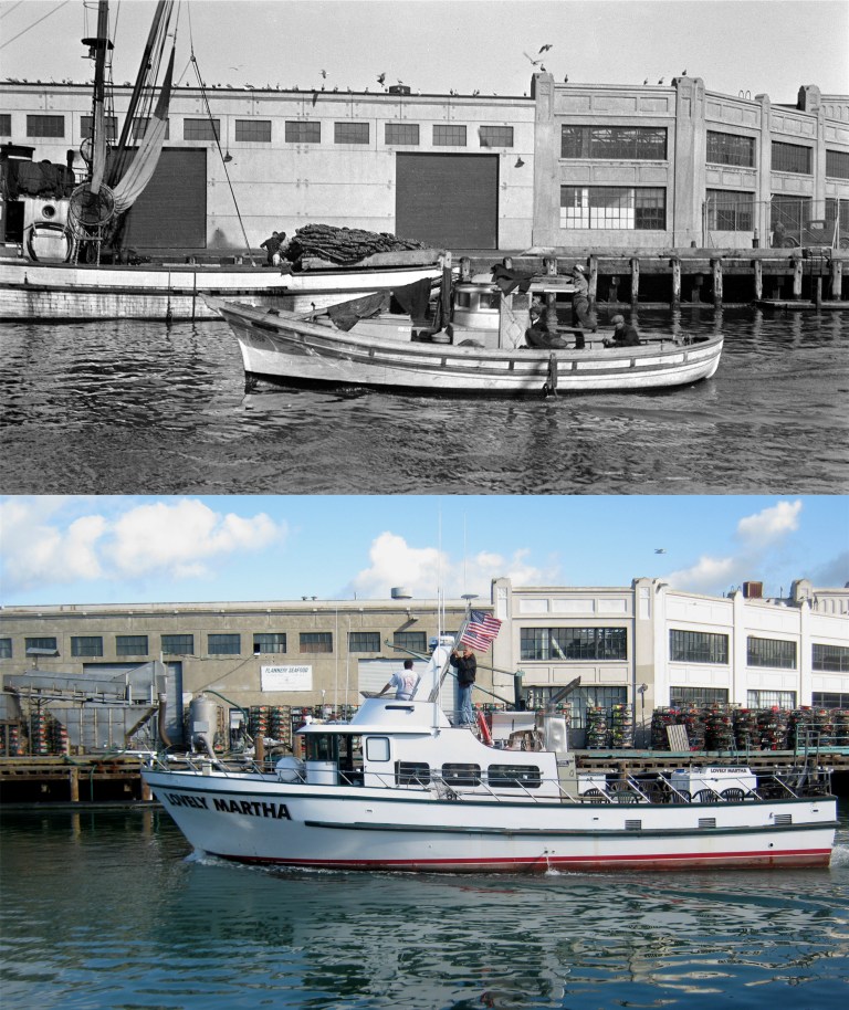 Pier 45, Shed B at Fisherman’s Wharf in 1932: Those baskets on the pier in my picture are crab nets being stored on Pier 45 until crab season opens.
 The Fisherman’s Wharf Boat Lagoon in 1955: Now, you see, here’s the way my mind works; the vintage picture doesn’t say anything about who the three gentlemen on the left were, but I see three plain clothes cops investigating a crime scene. It could have been. Somewhere underneath all those crab nets in my picture are a fleet of fishing boats. (Opensfhistory.org)
 The end of Taylor Street north of Jefferson in the 1930s: I had a better line up with the old picture here on Taylor Street, but then a line of vintage cars past by and I took this picture. I like the two sea gulls on either side of the procession watching the vintage autos pass; a couple of car buffs. (Opensfhistory.org)
 The best views from land in San Francisco of Alcatraz Island are from Fisherman’s Wharf, seen in both these pictures from the very end of Pier 45. The vintage picture was taken in 1935. Al Capone and “Machine Gun” Kelly were on the island when the old picture was taken. The ferryboat was leaving from the Hyde Street Pier for Berkeley. . (Opensfhistory.org)
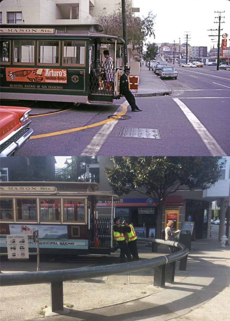 Three blocks south of Fisherman’s Wharf is the cable car turnaround at Bay and Taylor Streets, seen in 1964. It used to take only one person to push the car off the turntable back then. (San Francisco Pictures blog)
 Although there’s no geographical boundary I know of, the general rule is that the western side of Fisherman’s Wharf ends at the Hyde Street Pier. I wasn’t really going any further in this direction anyway. Still, I figured that I’d just shoot through the fence and tell people who worry about me that I ignored the sign.
 {The building at 706 Montgomery Street in San Francisco was a perfect setting for a murder. I had, in fact, thought so for a long time before anybody got killed in it.}
 Most of the story takes place at the 706 Montgomery Street building mentioned that houses artists and writers as tenants. The inside cover of the paperback has a drawing of the building and the floor where the tenants live and work. This Flickr image of the drawing is in better shape than the one in the old paperback I bought. Janet Keith, a socialite who lives in Pacific Heights and rents a room in the Montgomery Building to become a writer, narrates the book and identifies the year the story takes place on page 180.
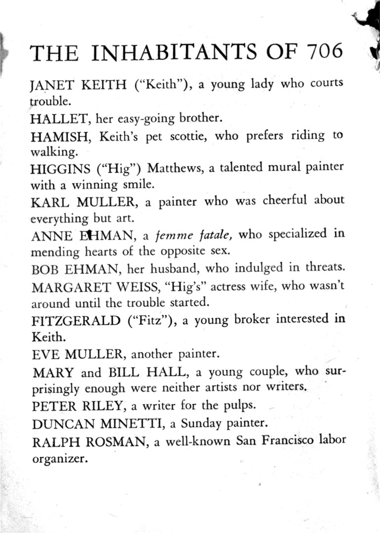 A prelude to the story is a list of the people staying at 706 Montgomery Street when the first brutal murder is committed. One of them is guilty.
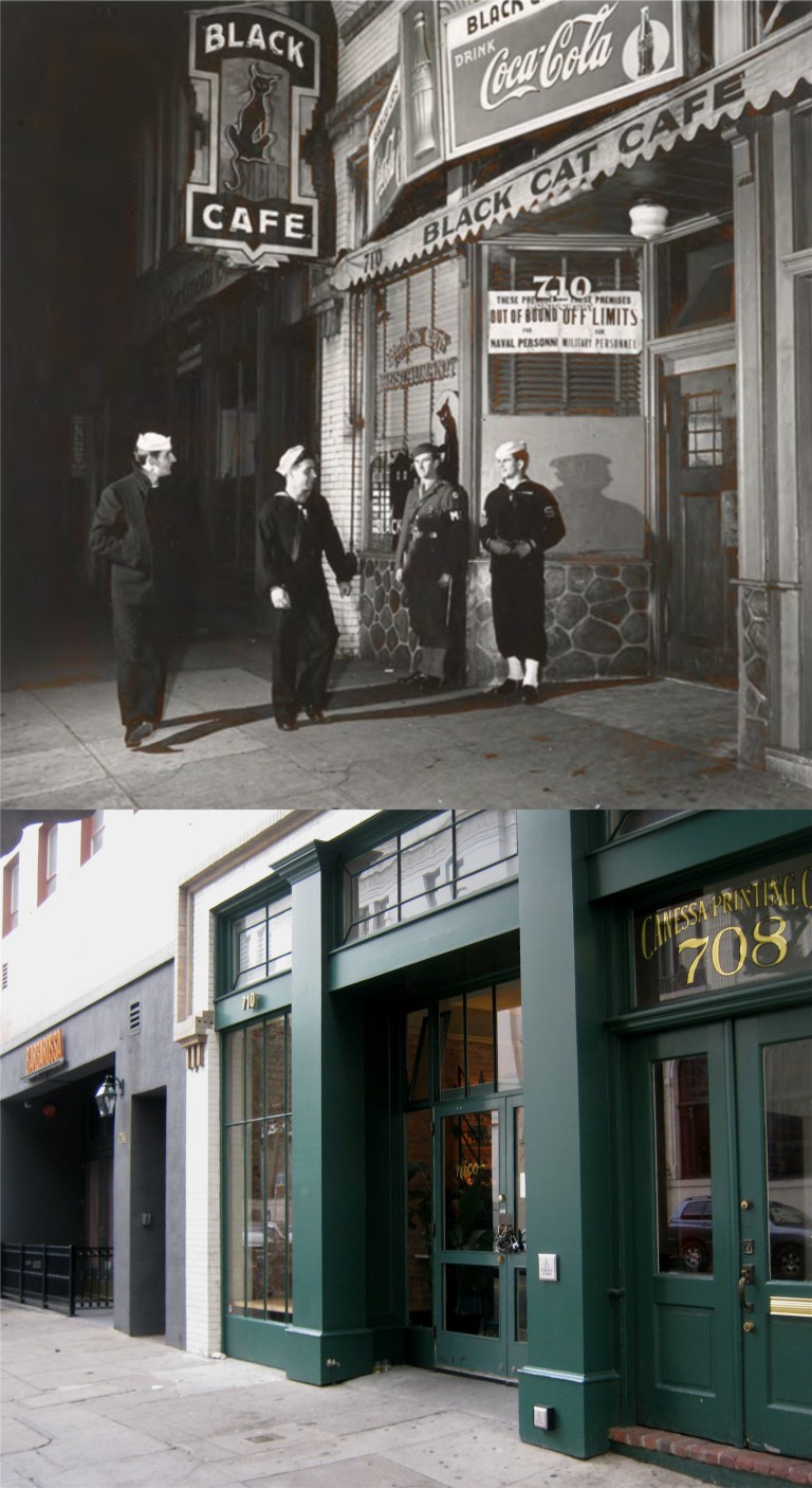 706 Montgomery is a fictitious address that sounds like another historic building you’ll see in the next photo. Today 706 Montgomery Street would have been in the building on the northeast corner of Montgomery and Washington Streets next to where the old Black Cat Café used to be. (Vintage photo from the Thomas Reynolds Gallery)
 When you think of an old building on Montgomery Street that was a haven for artists and writers and you know your San Francisco history, you’ll think of the Montgomery Block, the “Monkey Block”. This is probably where Mary Collins got the idea for her 706 Montgomery Street setting. Janet Keith makes a reference to the old building.
 After inadvertently leading the police to a second murder, Janet is arrested by the police as a suspect and taken down to the old Hall of Justice Building on Kearny Street across from Portsmouth Square. She’s kept there throughout the night and released in the morning.
 Fearing for Janet’s life with the murderer at large, Janet’s father hires a bodyguard named Spike to follow and protect her. They become friends and Janet is always able to talk Spike into going along with her schemes, like breaking and entry, as she tries to solve the murders without the help of the police. One evening Janet and her bodyguard park at the top of Telegraph Hill and go down to Montgomery Street in an attempt to break into the house where the related murder victims lived to look for clues.
 Janet and Spike decide to go back to the house and break in through the back way avoiding the policeman in the front. Janet can be as clumsy as she is cunning and she drops a drawer making a racket and alerting the cop guarding the house. Janet bolts out the back door hoping to lead the policeman away from Spike and they become separated. Tired and scared she looks for a place on Telegraph Hill to meet up with Spike.
 Here’s a picture during the 1950s of the old Shadows Restaurant, now closed and empty. (Flickr)
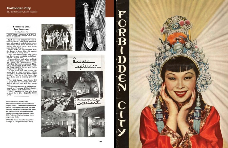
 The Forbidden City was up in the second floor of this building on Sutter Street.
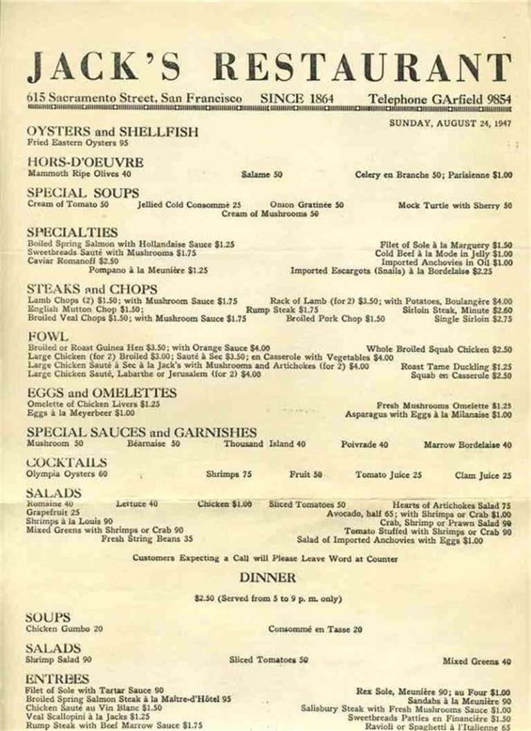 Janet, Fitzgerald, and Spike have lunch at Jack’s Restaurant on Sacramento Street near Montgomery.
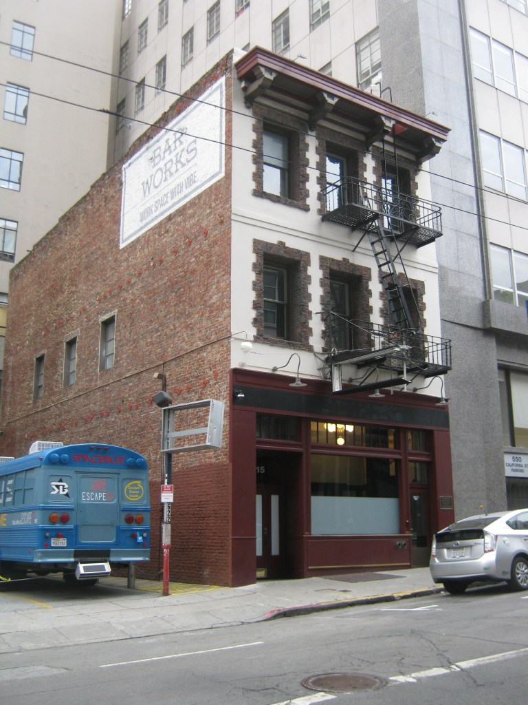 For many years, Jack’s Restaurant, the second oldest and one of the finest restaurants in San Francisco was in this building. The restaurant closed in 2009.
 I never paid much attention to the crime drama television show ‘Ironside’ that premiered in 1967 until I started watching them again on DVD. As I mentioned from a few posts I’ve done in the past, they’re actually for the most part entertaining little mystery shows with occasional views of interesting San Francisco locations, although most of each of the episodes were filmed in a studio. Raymond Burr plays Robert T. Ironside, a police lieutenant crippled by a sniper’s bullet in the pilot episode. He’s assisted by Barbara Anderson as Officer Eve Whitfield. Eve often gets double takes as a female police officer, which apparently was novel back then. Eve was a good cop and she could be tough when she had to, even though she often dressed like a tour guide from Disneyland. Don Mitchell plays Mark Sanger, an ex-con that Ironside sees promise in and employs him. Mark is basically Ironside’s man servant in early seasons pushing Ironside around in his wheelchair or driving him around in his armored truck. This may be racially offensive to some today, but Mark eventually joins the force as a police officer in later seasons. Don Galloway is Sergeant Ed Brown, the handsome detective who you sometimes hope was fooling around with Eve behind Ironside’s back. He even misquotes Herb Caen in one episode referring to San Francisco as “Baghdad on the Bay” rather than ‘Baghdad by the Bay’. Most of the San Francisco locations were filmed as Ironside’s truck is heading toward a crime site or an investigation. (IMDb)
 Ironside’s truck is often seen entering onto or exiting from the Washington Street side of the old Hall of Justice Building on Kearny Street across from Portsmouth Square.
 Although the old Hall of Justice Building was closed and demolition had begun on it when the show premiered, it was used as Ironside’s base of operations. Washington Street is on the left side of the building, Kearny at the bottom, and Merchant Street on the right. A Hilton Hotel occupies the spot today.
 In an episode from 1968 two criminals break out from one of the jails cells in the Hall of Justice and have taken Ironside and Eve hostage. This is a picture from the actual jail cell block in the Hall of Justice from a link about the Hall of Justice Building sent to me in a comment from a viewer to my blog, Irunnningynn. I’ll include the link to the interesting article she sent me at the end of this post.
 The bad guys who have taken Ironside and Eve hostage allow Ironside to take a telephone call from Mark to avoid suspicion. Realizing that Mark is returning to the office, Ironside sends Mark on a lengthy research project at the San Francisco Main Library on Larkin Street to protect him, much to Mark’s confusion.
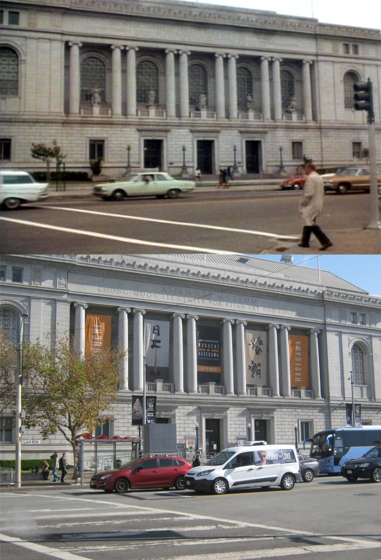
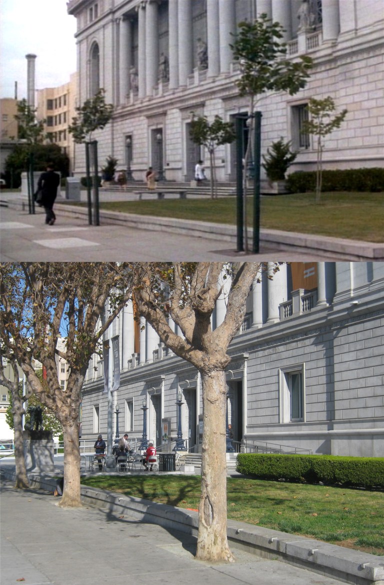 These are two views from the scene of the old location of the San Francisco Main Library back then. The building is now the Asian Art Museum.
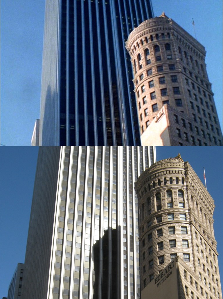 In a camera scene starting at the top and working its way down, the old Hobart Building on Market Street, with the new back then Wells Fargo Building behind it, is shown in one of the episodes from the first season.
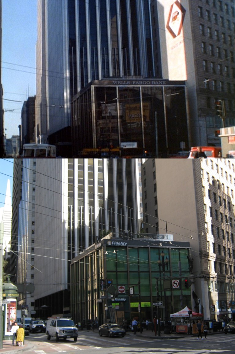 The Hobart Building operators let Wells Fargo paint their stagecoach on the side of the building back then.
 An episode that aired December 7th 1967 shows the view down Vallejo Street on Telegraph Hill. I was up on Telegraph Hill at this spot last June and got a reasonable comparison to the TV shot when I was working on another post, although a tree blocks a lot of the old view now. That looks like a Coca Cola sign on the doorway of the building on the corner of Vallejo and Montgomery Streets in the TV shot. There may have been a grocery store there back then.
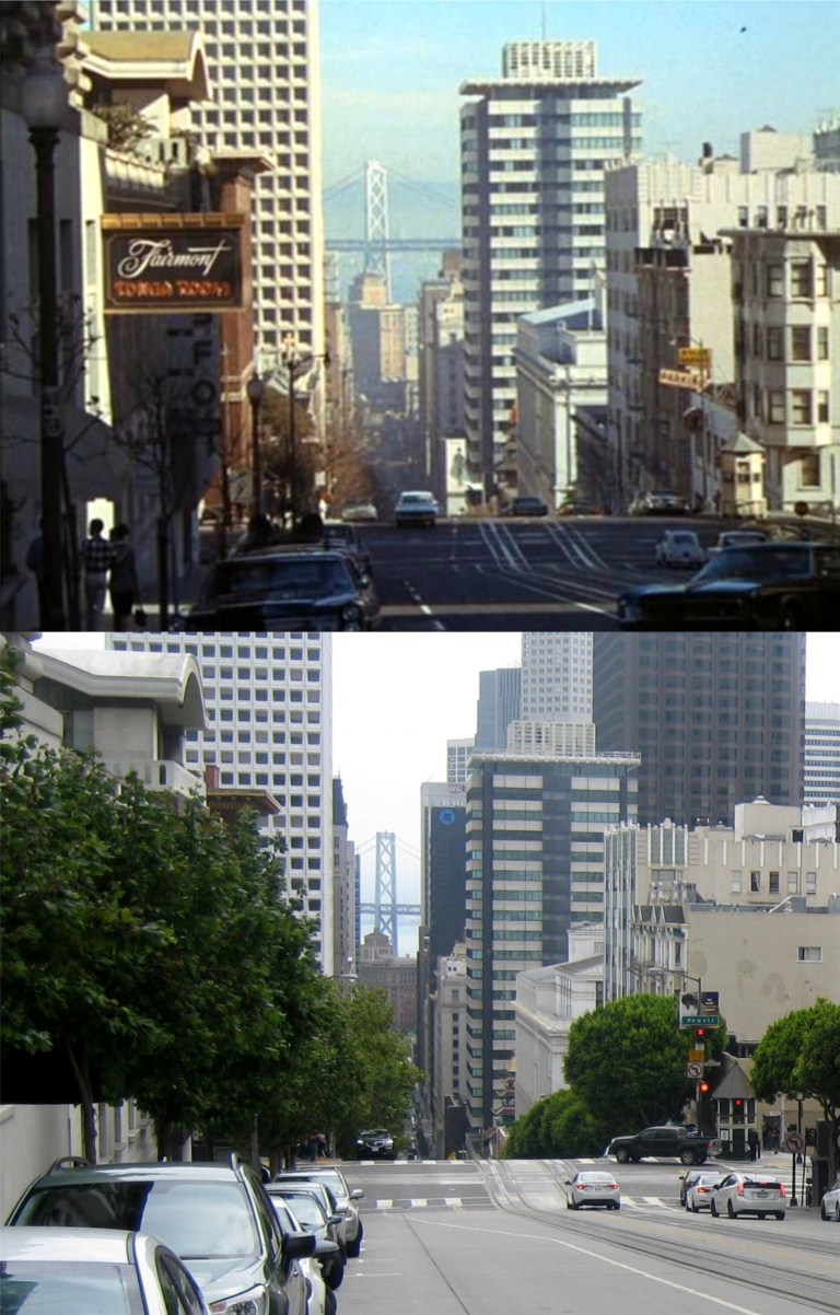 A view from an early episode looking down Nob Hill along California Street in 1967: There’s no Bank of America Building yet, and you can see the Fairmont Hotel’s Tonga Room on the left and the old Crest Garage building on the corner of Powell and California Streets on the right. The Crest Garage building was still around when I took this picture in 2017.
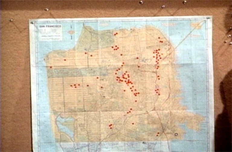 In an episode that aired November 30th 1967, Ironside’s team is trying to break up a stolen car ring operating out of San Francisco. Here, he reviews a map of San Francisco with Eve and refers to the red dots on the map as to where cars were stolen in San Francisco in the past six months. That may be less than the amount of cars stolen in San Francisco in one week nowadays.
 Whenever there’s a crime scene or a crime in commission, Mark always seems to drive Ironside north on Hyde Street coming down from Russian Hill to get there. In this scene they’re heading to an auto wrecking yard to break up a stolen car ring. They’re two blocks away from the Bay, and I doubt if there was an auto wrecking yard within fifty miles from here!
 Another often used San Francisco location in the show was the old Spreckels Mansion on Washington Street. Whenever the crime involved a well-to-do family, they always seem to live here. Ironside’s truck is turning into the courtyard entrance from Washington Street, seen in the early morning shadows from Lafayette Park across the street in my picture.
 The last I heard, the current resident of the Spreckels Mansion is authoress Danielle Steel.